
Park Green
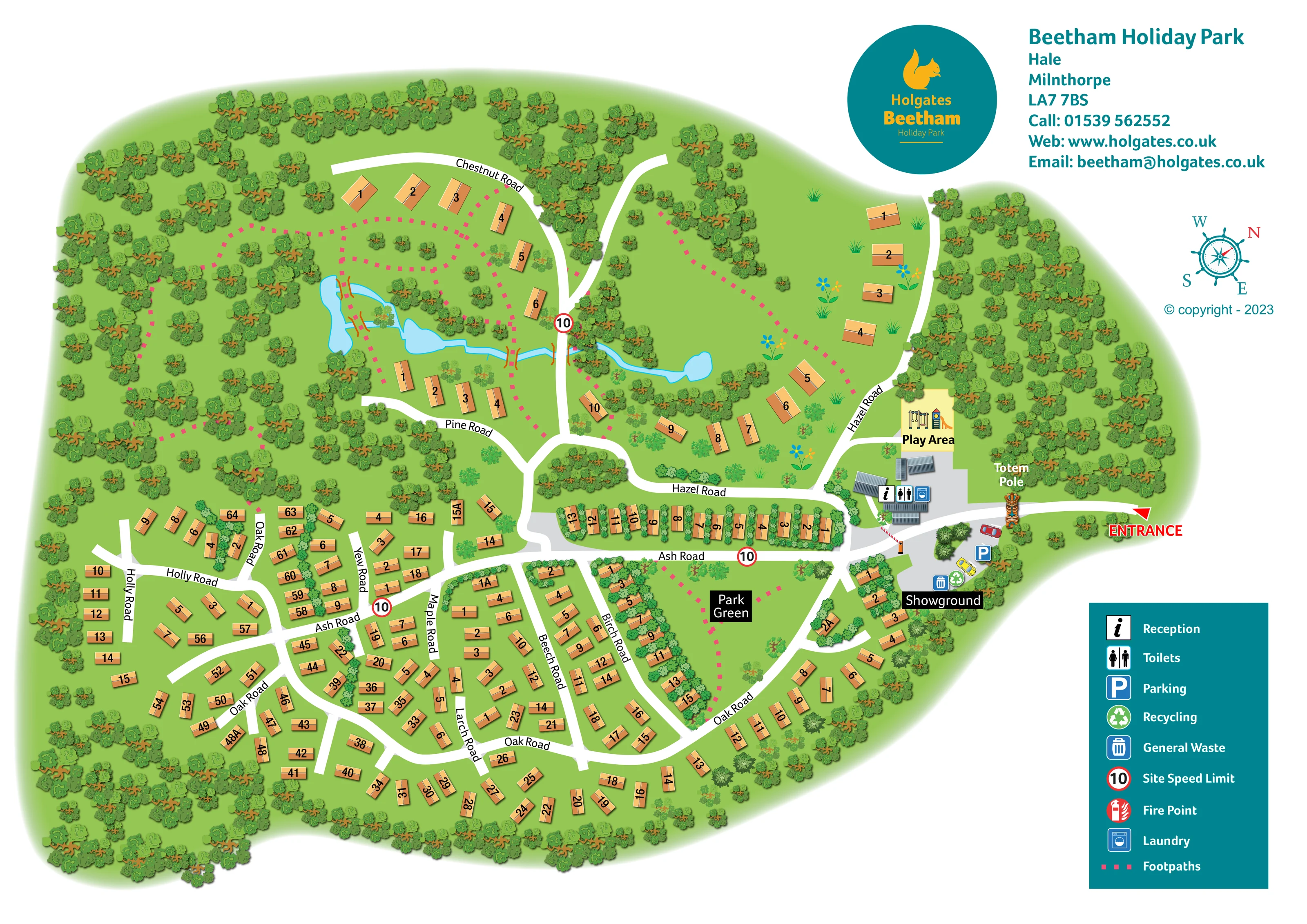
A substantial triangular green lies between Ash Road, Birch Road and Oak Road, crossed by pink dotted footpaths.
ILLUSTRATED PARK MAP · P021
Hale, Milnthorpe · United Kingdom
 Enlarge the map ↗
A SENSE OF THE PLACE
Beetham Holiday Park is based at Hale, Milnthorpe. The site is situated in the Arnside and Silverdale National Landscape near Hale and Milnthorpe. Holiday caravan and lodge ownership is offered; the park is described as owner exclusive.
Onsite facilities include a children's playground and field, park-wide Wi-Fi and laundry. The pool complex described on the page is at Silverdale, approximately 15 minutes' drive away.
LOOK CLOSER
A substantial triangular green lies between Ash Road, Birch Road and Oak Road, crossed by pink dotted footpaths.
Dense illustrated trees surround much of the park and fill the north-western walking area; smaller trees and hedges separate some accommodation rows.
An irregular light-blue chain of pond-like pools and narrow connecting water runs through the northern interior between the Chestnut, Pine and Hazel Road areas.
A prominently illustrated and labelled totem pole stands beside the entrance road and parking, providing a distinctive arrival landmark.
An information symbol identifies reception within the grey-roofed building cluster beside the entrance.
Toilet symbols are grouped with reception and laundry at the arrival buildings.
A blue washing-machine symbol marks laundry at the entrance-side service buildings.
A pale-yellow labelled area with illustrated swings and a slide sits immediately north of the reception buildings, beside Hazel Road.
An information symbol identifies reception within the grey-roofed building cluster beside the entrance.
Toilet symbols are grouped with reception and laundry at the arrival buildings.
A blue washing-machine symbol marks laundry at the entrance-side service buildings.
A pale-yellow labelled area with illustrated swings and a slide sits immediately north of the reception buildings, beside Hazel Road.
A blue parking symbol and illustrated cars identify the grey arrival area beside the Showground.
Recycling and general-waste symbols are placed together near the entrance parking and Showground.
A black-backed Showground label marks the arrival-side area adjacent to parking and nearby numbered accommodation symbols.
A substantial triangular green lies between Ash Road, Birch Road and Oak Road, crossed by pink dotted footpaths.
Dense illustrated trees surround much of the park and fill the north-western walking area; smaller trees and hedges separate some accommodation rows.
An irregular light-blue chain of pond-like pools and narrow connecting water runs through the northern interior between the Chestnut, Pine and Hazel Road areas.
Pink square-dotted paths loop through the western woodland, connect the northern accommodation areas and cross Park Green. Small orange bridge-like marks indicate crossings over the water.
A red ENTRANCE label and triangular marker identify arrival from the right-hand edge. A striped barrier is illustrated at the junction beside reception.
The white road network is labelled Ash, Oak, Holly, Yew, Maple, Larch, Beech, Birch, Hazel, Pine and Chestnut Road.
A prominently illustrated and labelled totem pole stands beside the entrance road and parking, providing a distinctive arrival landmark.
Red-ringed 10 symbols appear at several internal road locations and are explained in the legend as the site speed limit.
A red fire-point symbol is included in the legend; a corresponding position is not clearly identifiable on the plan.
Park-wide Wi-Fi is mentioned in the operator information, but is not mapped as a facility or coverage area.
READING THE MAP
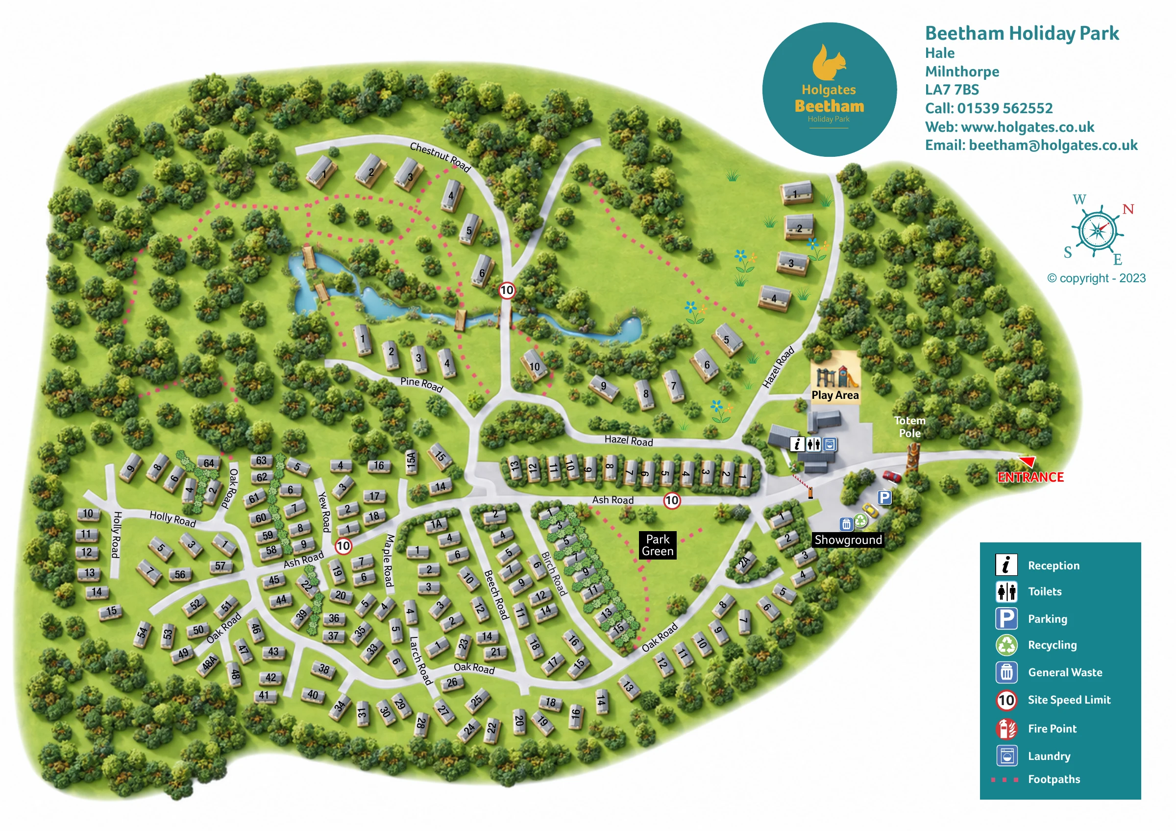
This illustrated map of Beetham Holiday Park at Hale, near Milnthorpe, brings a woodland holiday-home setting into a clear, self-contained visitor plan. Numbered accommodation sits beside a network of tree-named roads, while dense green planting, linked blue pools and pink dotted footpaths give the landscape a strong presence. The map balances the busier southern neighbourhoods with smaller, more spacious groups around Chestnut, Pine and Hazel Road.
Arrival is easy to recognise on the right-hand side, where a red entrance marker leads towards a distinctive totem pole, parking and the reception buildings. Toilets and laundry are identified at the same service cluster, with an illustrated Play Area just beyond it. Park Green supplies another useful landmark within the accommodation layout.
Teal Holgates branding and a matching symbol key complete the page without crowding the plan. For a park with many individual holiday homes and a branching road system, this sample shows how numbered units, memorable landmarks and separate walking routes can work together in one illustrated overview.
The single-page plan presents Beetham as an irregular green site enclosed by substantial belts of illustrated woodland. Its busiest accommodation area occupies the lower half, where Ash Road crosses the park and Oak Road curves around a network of shorter lanes. Holly, Yew, Maple, Larch, Beech and Birch Road organise the smaller neighbourhoods. Warm orange roof symbols carry black unit numbers, with hedges and trees separating selected rows.
The northern area has a different rhythm. Small groups beside Chestnut and Pine Road sit close to a pale-blue water feature, while Hazel Road curves through a more open area decorated with grass tufts and flowers. Pink square-dotted footpaths form loops through the western trees, pass between the northern groups and cross the water at small illustrated bridges. The same path treatment continues across the triangular Park Green in the south-east.
At the right-hand entrance, a labelled totem pole provides a memorable landmark before the grey parking and building area. Reception, toilets and laundry are marked together with service symbols. The adjacent Play Area uses a yellow background and an illustration of swings and a slide. Parking, recycling and general waste are shown near the black-backed Showground label, and a striped barrier marks the internal arrival junction.
White roads, black labels and red-ringed speed markers sit clearly against the green ground. The lower-right teal legend explains the principal symbols and footpath style, including a fire-point entry. Above it, a decorative compass supports orientation. The upper-right title, contact block and circular squirrel logo establish the park identity while leaving the illustrated layout as the page's main focus.
 Enlarge this map ↗
KEEP EXPLORING
Chosen for shared landscapes, accommodation or facilities.
 Explore the map ↗
United Kingdom
Illustrated lakeside park plan with numbered holiday units, leisure buildings and a looping Woodland Walk.
 Explore the map ↗
United Kingdom
A woodland estate park map combining caravan loops, touring pitches, riverside paths and Bruce’s Cave landmarks.
 Explore the map ↗
United Kingdom
Woodland camping, lodges, lakes and colour-coded bike trails at Avon Tyrrell Outdoor Centre.
Features may come from the sample artwork, its key or published park information. Approximate numbers describe the drawing and may cover only part of a park. They are intended to help you compare map examples. Current facilities and booking information should be checked with the park.
LET’S MAP YOUR PARK
For a map quotation, find your park and draw a rough boundary around it. The area you select helps us work out the design time and price.
Draw your park for a quote ↗Or talk to our map designers
01751 473136