
Dog-friendly area
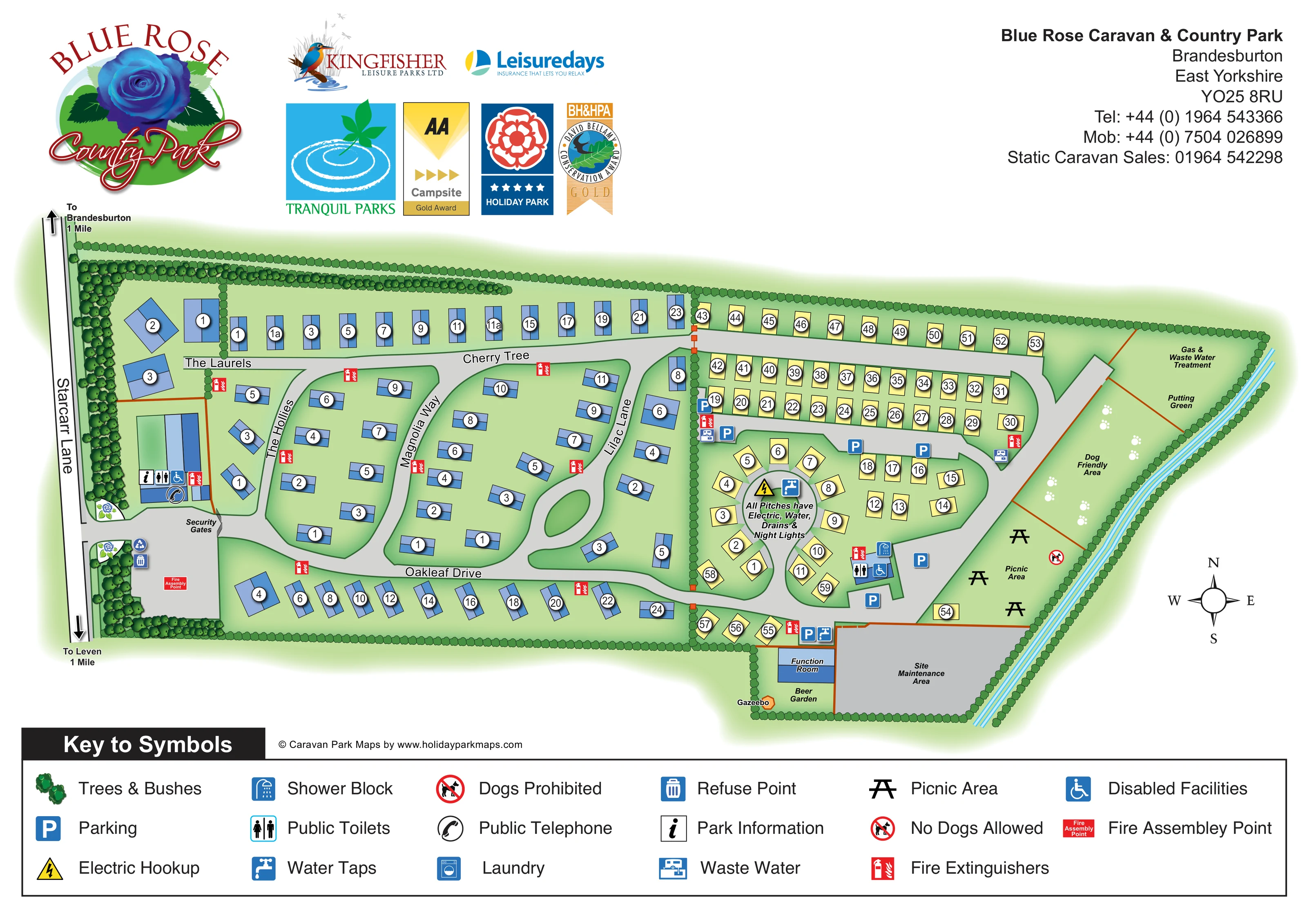
A labelled grassy area on the eastern boundary is decorated with white paw prints.
ILLUSTRATED PARK MAP · P413
Blue Rose Caravan & Country Park, Brandesburton, East Yorkshire · United Kingdom
 Enlarge the map ↗
A SENSE OF THE PLACE
Blue Rose Caravan and Country Park is an adults-only park between Brandesburton and Leven in East Yorkshire. Its rural location places it close to the Yorkshire Wolds and the facilities of the neighbouring villages.
Heated toilets and showers, an accessible wet room and a launderette support touring stays. The family-run park offers a quieter countryside setting, with local pubs and places to eat adding to the options nearby.
LOOK CLOSER
A labelled grassy area on the eastern boundary is decorated with white paw prints.
Continuous perimeter hedging, denser western tree planting and planted internal divisions frame the accommodation and recreation areas.
Parallel blue lines follow the sloping eastern boundary, suggesting a watercourse or drainage feature; no name or explicit identification is provided.
An information symbol marks the entrance-side building beside Starcarr Lane.
Toilet symbols appear at the entrance building and at the eastern amenity block; a shower symbol identifies the eastern block.
Wheelchair symbols mark facilities at both the entrance-side building and the eastern amenity block. They identify mapped provision, not the accessibility of all routes.
A laundry symbol is placed beside the eastern toilet and shower facilities.
A telephone symbol appears at the entrance-side building.
An information symbol marks the entrance-side building beside Starcarr Lane.
Toilet symbols appear at the entrance building and at the eastern amenity block; a shower symbol identifies the eastern block.
Wheelchair symbols mark facilities at both the entrance-side building and the eastern amenity block. They identify mapped provision, not the accessibility of all routes.
A laundry symbol is placed beside the eastern toilet and shower facilities.
A telephone symbol appears at the entrance-side building.
The touring-area annotation reads 'All Pitches have Electric, Water, Drains & Night Lights', accompanied by electric hookup and water symbols.
Water and waste-water service symbols are distributed around the eastern pitches and southern facilities. Refuse and recycling-style symbols appear near the entrance.
Blue parking symbols mark several locations around the eastern accommodation and amenity areas.
Red extinguisher symbols are distributed through both accommodation sections. A labelled fire assembly point is shown in the entrance forecourt.
A blue building labelled Function Room sits along the southern edge of the eastern section.
A beer garden is labelled immediately south of the function room, with a small gazebo illustrated at its western corner.
A putting green occupies the upper part of the narrow eastern recreation strip.
A labelled grassy area on the eastern boundary is decorated with white paw prints.
Three picnic-table symbols mark the lower eastern recreation strip. A no-dogs symbol is placed within this picnic area.
A large grey site maintenance area occupies the south-eastern corner; Gas & Waste Water Treatment is labelled at the north-eastern tip.
The entrance from Starcarr Lane is labelled Security Gates.
The Laurels, Cherry Tree, The Hollies, Magnolia Way, Lilac Lane and Oakleaf Drive name the internal routes through the blue-unit section.
Starcarr Lane runs along the western edge, with opposite arrows towards Brandesburton and Leven, each labelled one mile on the artwork.
Continuous perimeter hedging, denser western tree planting and planted internal divisions frame the accommodation and recreation areas.
Parallel blue lines follow the sloping eastern boundary, suggesting a watercourse or drainage feature; no name or explicit identification is provided.
READING THE MAP
This illustrated map of Blue Rose Caravan & Country Park presents a landscaped caravan park at Brandesburton in East Yorkshire. The plan stretches from the entrance on Starcarr Lane to a distinctive recreation strip along the eastern boundary, with trees and hedges enclosing the accommodation areas. Blue caravan-style units and pale yellow pitches create an immediate visual distinction between the two main sections, while named roads and numbered positions help visitors find their way through the site.
The artwork brings practical facilities and leisure spaces into the same view. Information, toilets and accessible-facility symbols appear near the entrance, with showers, laundry and further facilities in the eastern section. A putting green, dog-friendly lawn and picnic area occupy the edge of the park, while a function room, beer garden and gazebo sit towards the south.
The large rose logo, botanical road names and green landscape treatment give the page a recognisable country-park character. A broad symbol key beneath the plan supports everyday wayfinding without crowding the accommodation layout with long explanations.
The map is arranged as a single landscape-format site plan, framed by branding above and a comprehensive symbol key below. Starcarr Lane runs down the western side, with directional arrows towards Brandesburton and Leven. The entrance passes through labelled security gates into a forecourt beside the park information building, where toilet, accessible-facility and telephone symbols are grouped. Refuse symbols and a fire assembly point are also shown near arrival.
Across the western and central sections, blue caravan-style units sit around planted road loops and long perimeter rows. The Laurels and Cherry Tree label the upper route, while The Hollies, Magnolia Way and Lilac Lane run through the interior. Oakleaf Drive follows the lower edge. Circular white number badges keep the accommodation positions readable against the blue graphics.
A hedge-lined division separates this area from the pale yellow pitches to the east. Here, straight rows give way to a smaller circular arrangement around a prominent message about electric, water, drains and night lights. Parking, water, waste-water and fire symbols are placed around the roads. An eastern amenity block carries shower, toilet, laundry and accessible-facility symbols.
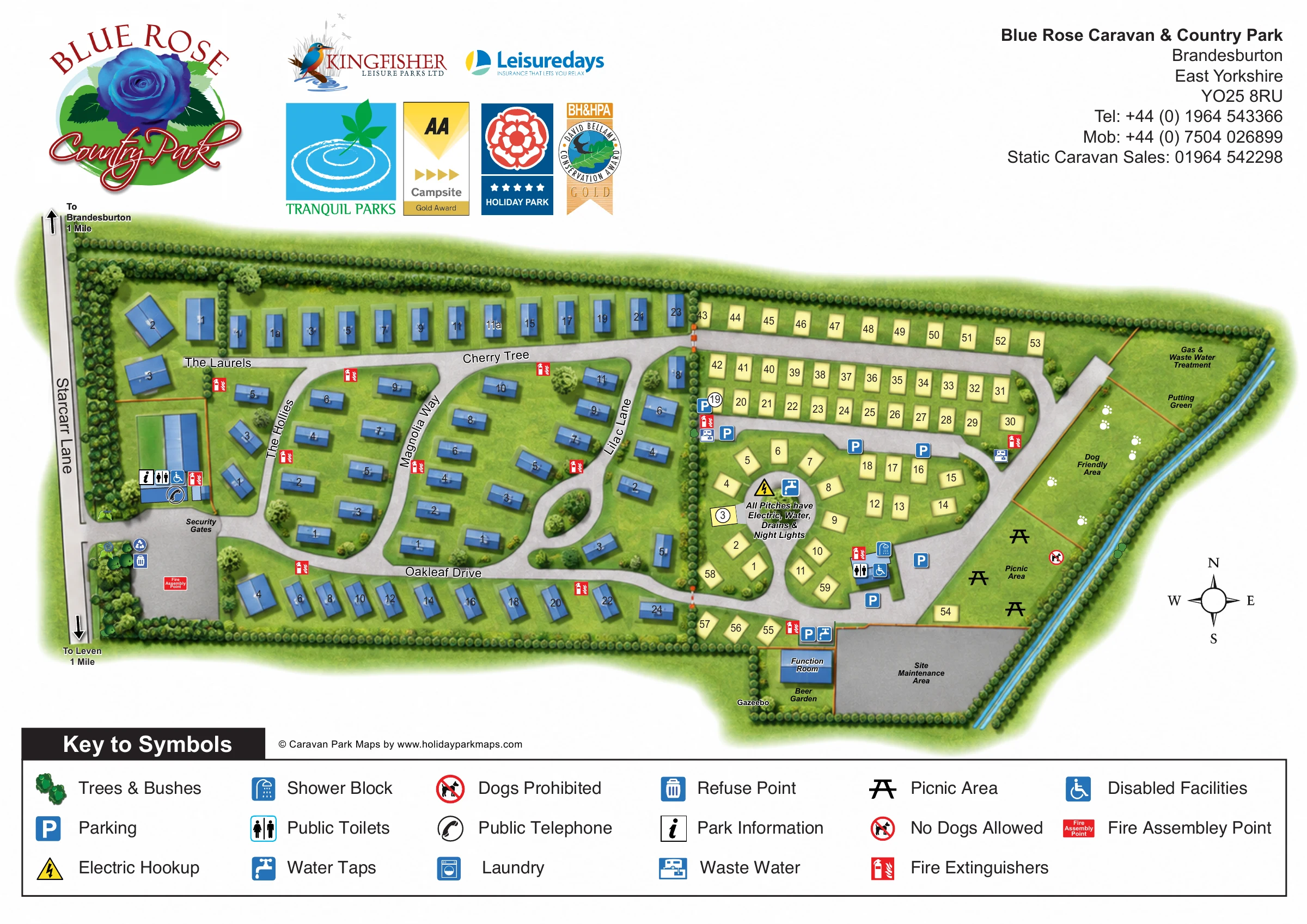
Along the sloping eastern boundary, the plan labels a putting green, a dog-friendly area marked with paw prints, and a picnic area with table symbols and a dog-restriction symbol. The function room, beer garden and gazebo occupy the southern edge beside a grey maintenance yard. Gas and waste-water treatment is labelled at the opposite tip. Parallel blue boundary lines add a water-like landscape detail without a specific label. The accompanying detail views enlarge the footer legend of this same artwork; they do not show additional sections or accommodation.
 Enlarge this map ↗
KEEP EXPLORING
Chosen for shared landscapes, accommodation or facilities.
 Explore the map ↗
United Kingdom
Ashby Park map with seven fishing lakes, colour-coded accommodation and illustrated wooded shorelines.
 Explore the map ↗
United Kingdom
Woodland-framed Barnsoul map with mixed accommodation, shared facilities and paw-marked walking routes.
 Explore the map ↗
United Kingdom
Colour-coded park map with numbered holiday-home areas, touring pitches, camping and an illustrated leisure hub.
Features may come from the sample artwork, its key or published park information. Approximate numbers describe the drawing and may cover only part of a park. They are intended to help you compare map examples. Current facilities and booking information should be checked with the park.
TAKE A CLOSER LOOK
View the illustrated map in detail or choose a file to download. These are sample maps; contact the park for current visitor information.


LET’S MAP YOUR PARK
For a map quotation, find your park and draw a rough boundary around it. The area you select helps us work out the design time and price.
Draw your park for a quote ↗Or talk to our map designers
01751 473136