
Dog walking area
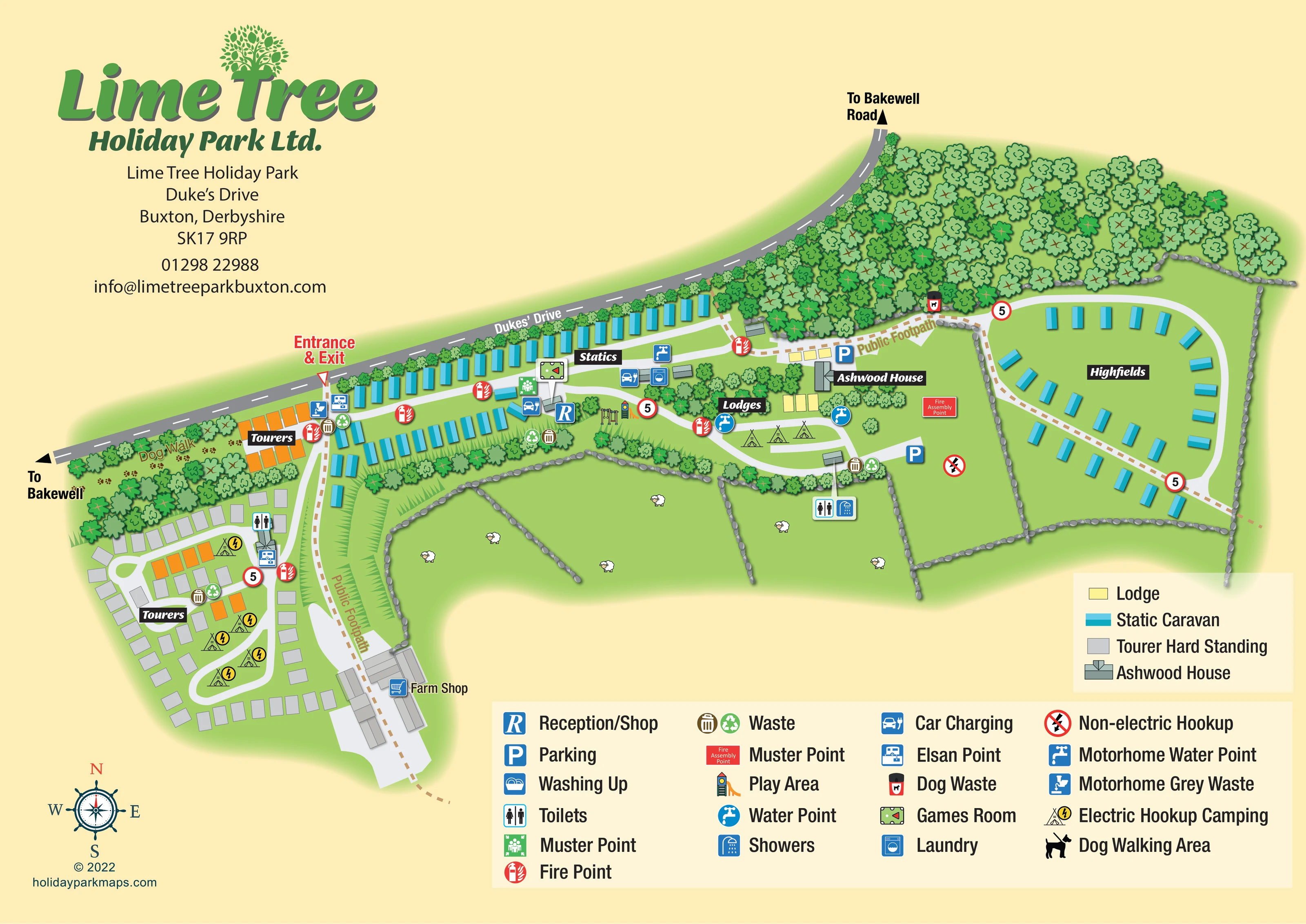
A tree-edged strip west of the entrance is labelled Dog Walk and illustrated with paw prints.
ILLUSTRATED PARK MAP · P521
Lime Tree Holiday Park, Duke’s Drive, Buxton, Derbyshire · United Kingdom
 Enlarge the map ↗
A SENSE OF THE PLACE
Lime Tree Holiday Park is located near Buxton, with a wooded limestone gorge and former railway viaduct forming a distinctive backdrop. Camping, touring, glamping and self-catering accommodation offer several ways to stay.
Options include pods, lodges, caravan hire and a holiday house. The setting combines access to Buxton with the countryside and walking landscapes of the Peak District, while the map helps guests navigate the different accommodation areas.
LOOK CLOSER
A tree-edged strip west of the entrance is labelled Dog Walk and illustrated with paw prints.
Dense illustrated woodland dominates the upper-right edge, with tree and shrub belts separating other accommodation areas.
Grey stone-wall lines divide green fields along the lower edge. Small sheep illustrations establish the surrounding pastoral setting.
A blue R marker identifies reception/shop at the central junction between the static-caravan rows and the eastern accommodation areas.
A labelled group of buildings stands at the southern end of the western public footpath.
A pool-table pictogram marks the games room near reception.
Illustrated swings and a slide identify a play area immediately east of reception.
Toilets are marked in the western touring area; a combined toilets-and-showers marker serves the central eastern camping area.
A blue R marker identifies reception/shop at the central junction between the static-caravan rows and the eastern accommodation areas.
A labelled group of buildings stands at the southern end of the western public footpath.
A pool-table pictogram marks the games room near reception.
Illustrated swings and a slide identify a play area immediately east of reception.
Toilets are marked in the western touring area; a combined toilets-and-showers marker serves the central eastern camping area.
A washing-machine symbol appears among the service buildings east of reception.
A washing-up symbol is included in the legend, but its position is not clearly identifiable on the plan.
Tap symbols mark water provision along the static-caravan area and near the lodges and camping loop.
Dedicated motorhome water and grey-waste symbols distinguish these services from ordinary water taps, including provision near the entrance.
Elsan symbols appear near the entrance and within the western touring area.
Car-and-plug symbols mark charging locations around the central service and reception area.
Blue P markers identify parking near Ashwood House and beside the eastern camping area.
Paired brown bin and green recycling symbols are distributed around the touring, reception and camping areas.
Red fire-point markers recur along the internal routes. A green muster symbol near reception and a red Fire Assembly Point label in the eastern field identify assembly locations.
A tree-edged strip west of the entrance is labelled Dog Walk and illustrated with paw prints.
A dog-waste bin symbol is positioned beside the public footpath at the woodland edge near Highfields.
Dense illustrated woodland dominates the upper-right edge, with tree and shrub belts separating other accommodation areas.
Grey stone-wall lines divide green fields along the lower edge. Small sheep illustrations establish the surrounding pastoral setting.
A red Entrance & Exit label marks the access from Duke’s Drive. Directional arrows point towards Bakewell and Bakewell Road.
Brown dashed routes run south beside the touring area and farm shop, and east along the woodland boundary before crossing Highfields.
White internal lanes connect the accommodation zones, with several red-ringed 5 markers placed along the roads.
Park information identifies a wooded limestone gorge and former railway viaduct as distinctive surroundings; neither is explicitly drawn or labelled in this artwork.
READING THE MAP
This illustrated map of Lime Tree Holiday Park in Buxton brings together a varied accommodation layout and a distinctly green Derbyshire setting. The park stretches beside Duke’s Drive, with touring areas to the west, static-caravan rows through the centre, and lodges, camping and the separate Highfields area towards the east. Woodland, stone-wall boundaries and surrounding pasture give the plan a recognisable countryside character without obscuring the visitor information.
The design uses turquoise caravans, pale-yellow lodges and grey hard standings to separate the main accommodation types. White internal lanes stand apart from the grey approach road, while brown dashed public footpaths show walking routes through and beyond the site. Reception, the play area, games room, farm shop and practical service points are presented through a combination of pictograms and short labels.
A large tree-themed logo anchors the upper-left corner, balanced by a compass and clear legend panels below. This sample is particularly relevant to mixed holiday parks needing one coherent map for arrival, accommodation areas, everyday facilities and pedestrian routes.
The single landscape plan follows the park’s elongated shape beneath Duke’s Drive. A red entrance-and-exit label establishes the arrival point, with internal lanes branching towards the western touring loops and the central reception area. Long turquoise static-caravan rows follow the roadside and the lane below it. Further east, Highfields has a separate rounded road layout, with caravans arranged around and within the loop.
Reception sits at a useful visual junction near the games room and an illustrated play area. Nearby symbols identify car charging and laundry. Small pale-yellow lodge groups surround the labelled Ashwood House, while tent drawings occupy the adjoining camping loop. Electric-hook-up camping is marked within the western touring section; a separate non-electric symbol identifies the eastern camping field. The tent drawings indicate accommodation use rather than a fixed pitch count.
The map includes toilets, showers, water points, Elsan disposal and dedicated motorhome water and grey-waste services. Repeated bin, recycling and fire-point symbols make practical facilities visible across the site. Parking is marked near Ashwood House and the camping area, and both muster and fire-assembly locations are shown. Washing-up facilities appear in the legend, without a clearly distinguishable mapped position.
Brown dashed public footpaths provide a second route network: one passes the western touring area and labelled farm shop, while another follows the woodland edge and crosses Highfields. The dog walk is a planted strip with paw-print decoration. Dense tree canopies above and sheep-dotted fields divided by stone walls below frame the accommodation. A compact accommodation key and a larger facilities legend complete the page, alongside the branding, contact block and compass rose.
KEEP EXPLORING
Chosen for shared landscapes, accommodation or facilities.
 Explore the map ↗
United Kingdom
Woodland-framed Barnsoul map with mixed accommodation, shared facilities and paw-marked walking routes.
 Explore the map ↗
United Kingdom
Woodland holiday-park map with named accommodation areas, touring loops and illustrated recreation facilities.
 Explore the map ↗
United Kingdom
A woodland estate park map combining caravan loops, touring pitches, riverside paths and Bruce’s Cave landmarks.
Features may come from the sample artwork, its key or published park information. Approximate numbers describe the drawing and may cover only part of a park. They are intended to help you compare map examples. Current facilities and booking information should be checked with the park.
LET’S MAP YOUR PARK
For a map quotation, find your park and draw a rough boundary around it. The area you select helps us work out the design time and price.
Draw your park for a quote ↗Or talk to our map designers
01751 473136