
Lakes and elongated water feature
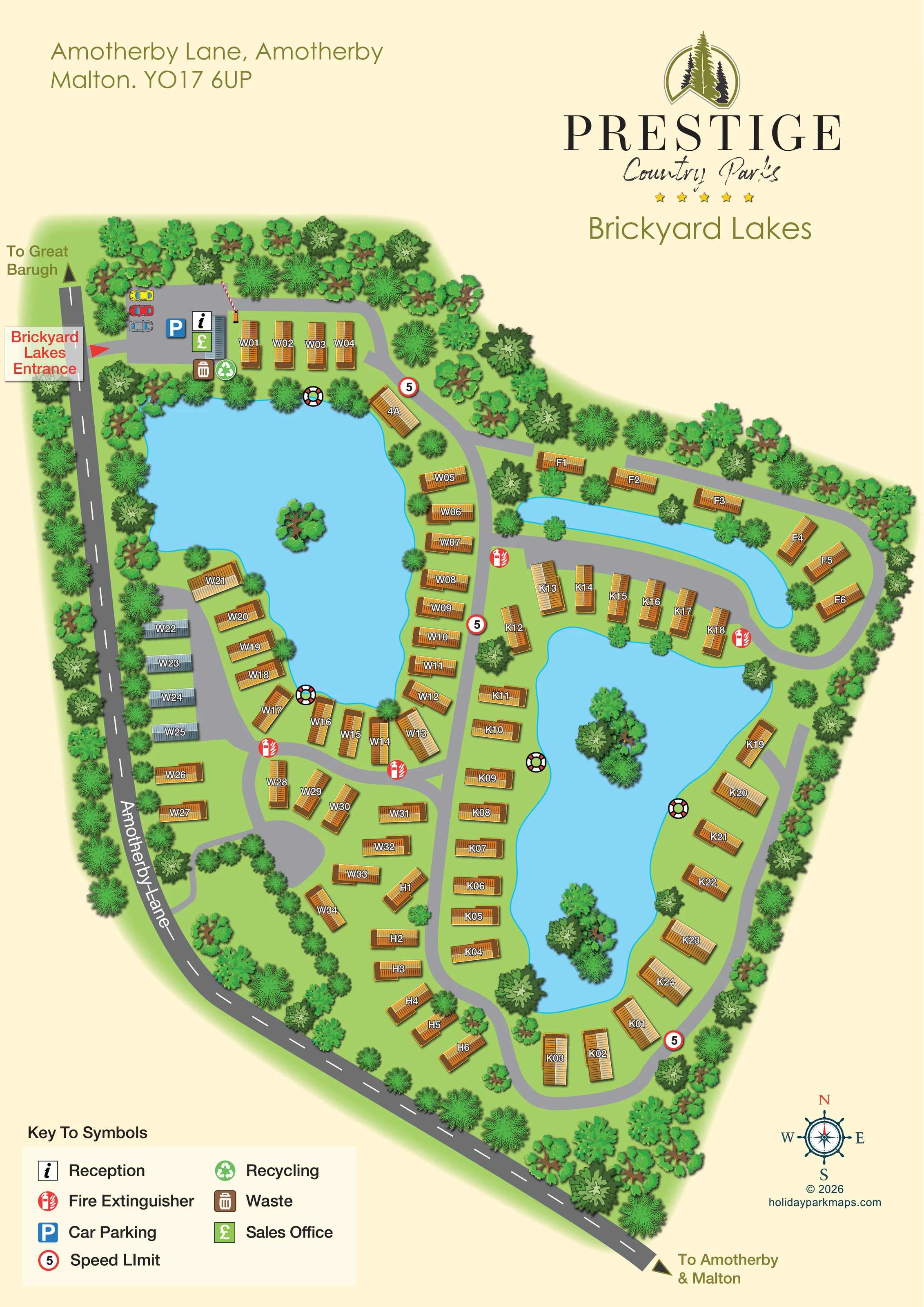
Two large irregular blue lakes dominate the plan, with a narrower curved water feature above the eastern lake.
ILLUSTRATED PARK MAP · P035
Brickyard Lakes, Amotherby Lane, Amotherby, Malton · United Kingdom
 Enlarge the map ↗
A SENSE OF THE PLACE
Brickyard Lakes offers holidays in the North Yorkshire countryside at Amotherby near Malton. Touring and tent camping take place in a separate, tree-lined area of the park.
Its setting suits a stay centred on the countryside and nearby market towns. The map provides an overview of the park's layout, helping visitors understand the relationship between the camping areas, holiday accommodation and access routes.
LOOK CLOSER
Two large irregular blue lakes dominate the plan, with a narrower curved water feature above the eastern lake.
Small wooded islands appear within both large lakes and provide distinctive visual landmarks.
Dense illustrated trees frame the park boundary, with smaller trees and shrubs between accommodation, roads and water.
The reception information symbol is placed at the entrance-side building beside the parking area.
A green pound-sign symbol identifies the sales office in the same entrance service cluster.
A blue parking symbol and illustrated cars mark parking immediately inside the entrance.
Waste and recycling symbols are grouped beside the entrance-side reception and sales facilities.
Repeated red fire-extinguisher symbols are distributed along the internal roads and accommodation groups.
Two large irregular blue lakes dominate the plan, with a narrower curved water feature above the eastern lake.
Small wooded islands appear within both large lakes and provide distinctive visual landmarks.
Dense illustrated trees frame the park boundary, with smaller trees and shrubs between accommodation, roads and water.
The reception information symbol is placed at the entrance-side building beside the parking area.
A green pound-sign symbol identifies the sales office in the same entrance service cluster.
A blue parking symbol and illustrated cars mark parking immediately inside the entrance.
Waste and recycling symbols are grouped beside the entrance-side reception and sales facilities.
Repeated red fire-extinguisher symbols are distributed along the internal roads and accommodation groups.
Life-ring illustrations appear at several points beside the two main lakes; these are not explained in the printed key.
A red entrance arrow leads from Amotherby Lane into the parking and reception area, with a red-and-white barrier drawn across the onward internal route.
Grey roads loop around the accommodation and water, with a central connecting route and a short rounded turning area in the western section.
Red-ringed signs displaying 5 are repeated on the internal roads and identified as speed-limit symbols in the key.
The named public road follows the western and southern edges, with directions towards Great Barugh at one end and Amotherby and Malton at the other.
A decorative compass rose at the lower right provides north, east, south and west orientation.
READING THE MAP
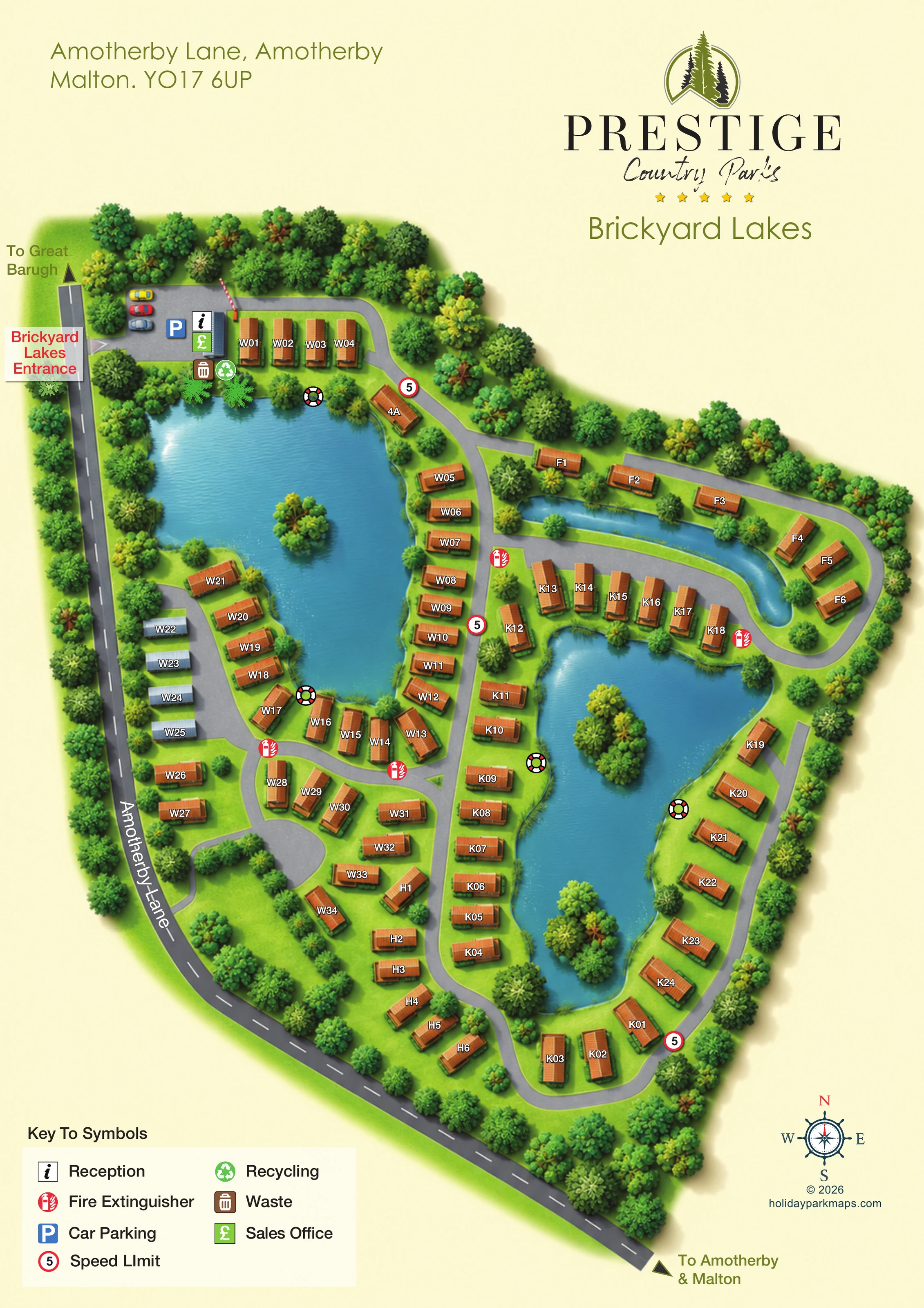
This illustrated map of Brickyard Lakes presents a lakeside holiday-home layout at Amotherby, near Malton in North Yorkshire. Two large blue lakes, small wooded islands and a narrower curved water feature give the plan its distinctive shape. Holiday homes follow the shorelines and sweeping internal roads, while a dense border of trees separates much of the accommodation from Amotherby Lane.
The visitor journey starts with a clearly marked entrance on the left. Parking, reception, the sales office and waste and recycling symbols are grouped together before the road continues into the park. Individual accommodation identifiers then help visitors follow the different lakeside groups, supported by a compact symbol key and compass rose.
The portrait page combines a practical site overview with prominent Prestige Country Parks branding. Warm timber-coloured buildings, bright water and varied green planting make the principal areas easy to distinguish. It is a useful sample for parks where water, landscaping and curved roads are more important to navigation than a conventional grid of pitches.
The plan places Amotherby Lane along the western and southern edges of the park, with arrows indicating Great Barugh in one direction and Amotherby and Malton in the other. A red entrance marker points into the upper-left arrival area. Illustrated cars and a parking symbol sit beside the reception and sales-office symbols, with waste and recycling nearby. A red-and-white barrier marks the continuation into the accommodation area.
The western lake has an irregular outline and a small tree-covered island. Holiday homes line its northern, eastern and southern edges, with further units between the lake and the boundary road. Across the central connecting road, a longer eastern lake forms the focus of another curving accommodation circuit. Several wooded islands break up its blue surface. Above it, a slender curved water feature separates an outer row of homes from an inner group. A smaller accommodation group occupies the lower-central space between the principal circuits.
Buildings are individually identified with white alphanumeric labels, and their varied angles follow the roads and shorelines. Red fire-extinguisher symbols and signs displaying 5 recur beside the routes. Life-ring illustrations mark several lakeside positions. Trees and shrubs are used both as a perimeter screen and as separators between buildings, water and roads.
The single portrait artwork includes a seven-entry key at lower left and a decorative compass at lower right. Its enlarged detail views show these same footer elements rather than additional areas of the park. The address and large branded heading occupy the open upper part of the page, leaving the central landscape as the main visual focus.
 Enlarge this map ↗
KEEP EXPLORING
Chosen for shared landscapes, accommodation or facilities.
 Explore the map ↗
United Kingdom
Ashby Park map with seven fishing lakes, colour-coded accommodation and illustrated wooded shorelines.
 Explore the map ↗
United Kingdom
Colour-coded accommodation, lakeside facilities and woodland routes at Burton Constable Holiday Park & Arboretum.
 Explore the map ↗
United Kingdom
Woodland holiday homes, named camping fields and farm buildings on a colour-coded Nether Wasdale park map.
Features may come from the sample artwork, its key or published park information. Approximate numbers describe the drawing and may cover only part of a park. They are intended to help you compare map examples. Current facilities and booking information should be checked with the park.
TAKE A CLOSER LOOK
View the illustrated map in detail or choose a file to download. These are sample maps; contact the park for current visitor information.

LET’S MAP YOUR PARK
For a map quotation, find your park and draw a rough boundary around it. The area you select helps us work out the design time and price.
Draw your park for a quote ↗Or talk to our map designers
01751 473136