
Central lake
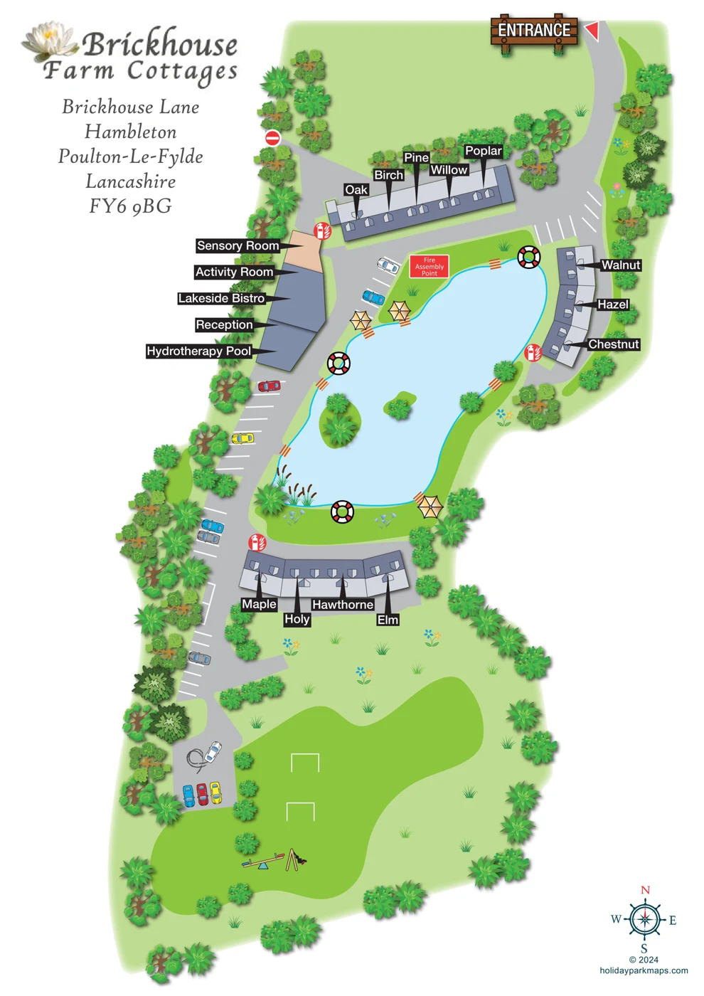
A large irregular pale-blue lake forms the plan's central focus, with a bright cyan outline and green banks. Fishing use is supplied by the catalogue rather than printed on the map.
ILLUSTRATED PARK MAP · P034
Brickhouse Lane, Hambleton, Poulton-le-Fylde, Lancashire · United Kingdom
 Enlarge the map ↗
A SENSE OF THE PLACE
Brickhouse Farm Cottages is based at Brickhouse Lane, Hambleton, Poulton-le-Fylde, Lancashire. The family-run retreat has twelve accessible cottages with two to five bedrooms; the largest sleep up to twelve.
Cottages provide level ground-floor and patio access, wet rooms and ceiling-track hoists. On-site facilities include a hydrotherapy pool, sensory room, restaurant, salon and shop. The grounds include an accessible fishing lake, children’s recreation area and woodland walk.
LOOK CLOSER
A large irregular pale-blue lake forms the plan's central focus, with a bright cyan outline and green banks. Fishing use is supplied by the catalogue rather than printed on the map.
Small green islands with stylised shrubs or trees are illustrated within the lake. Their real size, vegetation and accessibility cannot be inferred.
Stylised tree canopies and shrubs define much of the site edge and divide parking, buildings and lawns. Flower motifs, grass tufts and reeds add detail. These are illustrative landscape symbols, not a vegetation survey.
A named reception location within the amenity building group west of the lake. The pointer identifies a building section rather than an explicitly drawn doorway.
A labelled sensory room occupying the peach-coloured northern section of the amenity group.
A named activity room; the map does not specify its equipment or programme.
A named food and drink facility in the western amenity group. No menu, opening hours or visitor-access arrangements are supplied by the map.
A hydrotherapy pool is explicitly located within a roofed building section. The artwork does not show the pool interior, changing facilities or access equipment.
A named reception location within the amenity building group west of the lake. The pointer identifies a building section rather than an explicitly drawn doorway.
A labelled sensory room occupying the peach-coloured northern section of the amenity group.
A named activity room; the map does not specify its equipment or programme.
A named food and drink facility in the western amenity group. No menu, opening hours or visitor-access arrangements are supplied by the map.
A hydrotherapy pool is explicitly located within a roofed building section. The artwork does not show the pool interior, changing facilities or access equipment.
An unlabelled play area is represented by a seesaw and an A-frame swing illustration. These are facility illustrations, not accommodation symbols.
An open green recreation area contains goal-like white outlines. The map does not identify a regulation sports pitch or provide dimensions.
Parking is indicated by white bay markings and illustrative cars at several points. Neither total capacity nor designated accessible or charging bays is stated.
A red rectangular fire assembly marker is explicitly labelled. Its presence records the artwork's wayfinding information, not independently verified current emergency arrangements.
Red circular extinguisher-and-flame pictograms identify apparent fire equipment points. There is no key specifying the equipment provided.
Lifebuoy-style pictograms are distributed around the lake. The equipment specification and current availability are not stated.
Orange-and-cream striped rectangles cross the lake edge at several positions. They resemble small decks or waterside platforms, but the unkeyed artwork does not establish their exact use.
Top-view parasol illustrations suggest sheltered outdoor spots beside the lake. Seating arrangements are not drawn clearly enough to specify tables or benches.
Fishing and the lake's accessibility are supplied catalogue facts. The artwork depicts a lake but does not label it as a fishing facility or explain accessible fishing provision.
Level ground-floor and patio access, wet rooms and ceiling-track hoists are described in the supplied operator research. They are not individually mapped or assigned to named cottages.
An on-site salon is mentioned in the supplied research, without a location on this artwork.
An on-site shop is mentioned in the supplied research, without a location on this artwork.
A large irregular pale-blue lake forms the plan's central focus, with a bright cyan outline and green banks. Fishing use is supplied by the catalogue rather than printed on the map.
Small green islands with stylised shrubs or trees are illustrated within the lake. Their real size, vegetation and accessibility cannot be inferred.
Stylised tree canopies and shrubs define much of the site edge and divide parking, buildings and lawns. Flower motifs, grass tufts and reeds add detail. These are illustrative landscape symbols, not a vegetation survey.
A woodland walk is stated in the supplied operator research, but there is no named or keyed route on the map. Decorative perimeter trees are not sufficient to locate it.
READING THE MAP
Brickhouse Farm Cottages provides a distinctive example of mapping a compact cottage retreat rather than a conventional caravan park. The Hambleton site in Lancashire is arranged around a central lake, with named cottages grouped into three connected building ranges. Individual cottage names make the plan personal and help visitors distinguish accommodation within shared structures.
Reception and guest facilities are gathered on one side of the lake. The artwork identifies a sensory room, activity room, Lakeside Bistro and hydrotherapy pool, with parking along the internal drive and recreation space nearby. The lake gives the plan a strong central feature and helps tie the different building groups together.
This sample is particularly useful for cottage complexes, accessible-holiday businesses and small retreats with several shared facilities. It shows how an illustrated plan can explain the relationship between accommodation, parking and guest amenities without needing a large or complicated site. Named buildings, a clear arrival route and recognisable landscape features do much of the wayfinding work.
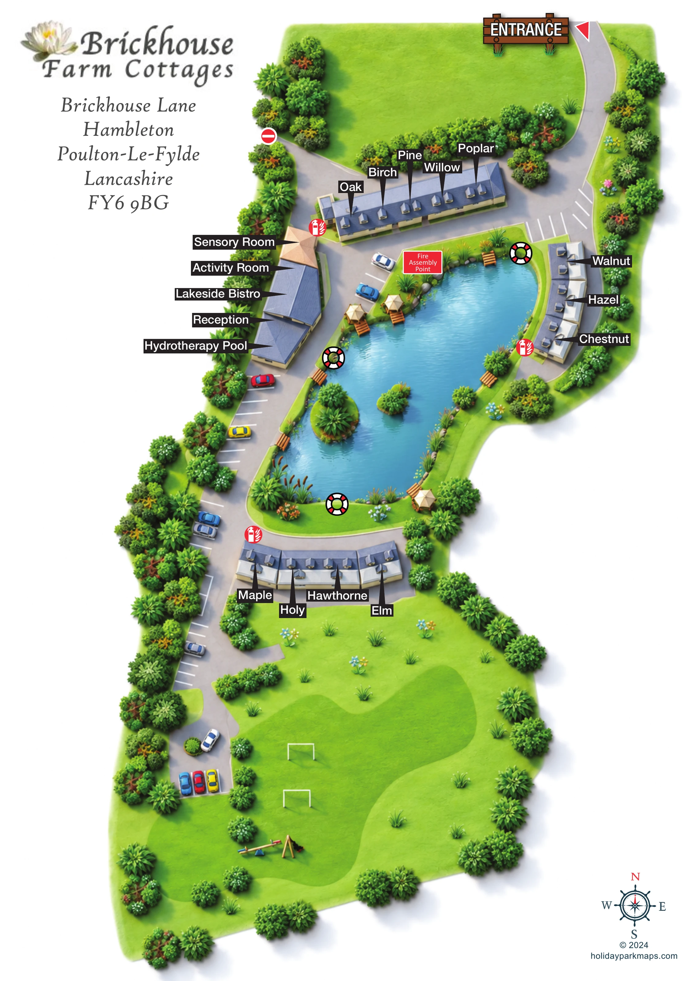
This single-page portrait map presents Brickhouse Farm Cottages as an elongated, lake-centred site. A lily logo and large italic address block occupy the upper-left white space, while the illustrated grounds extend from the entrance at the upper right to a broad recreation lawn near the bottom. A nautical-style compass rose and the designer's © 2024 credit sit outside the grounds at lower right; no scale bar is provided.
The plan is predominantly overhead. Accommodation appears as connected slate-grey roof groups with pale roof slopes, dormer details, black outlines and soft shadows. Individual cottages are identified by white names in black rectangular callouts with long triangular pointers. The northern terrace includes Oak, Birch, Pine, Willow and Poplar; further named accommodation follows the eastern shore and the southern end of the lake. These labels identify cottages rather than numbered pitches.
The amenity group stands west of the lake. Closely stacked pointers locate the Sensory Room, Activity Room, Lakeside Bistro, Reception and Hydrotherapy Pool. Grey drives connect the entrance and building groups, with white parking-bay markings and small coloured cars providing visual cues. A no-entry symbol marks a north-western spur, although the artwork does not explain a wider traffic system.
The pale-blue lake, edged in bright cyan, is the main visual anchor. Planted islands, reeds, striped waterside features and parasols give its banks detail. Lifebuoy-style symbols, red fire equipment pictograms and a labelled fire assembly point introduce safety information without a separate legend. Below the southern cottages, a bright-green lawn contains goal outlines, a seesaw and a swing illustration.
Layered green tree canopies, shrubs, flowers and grass tufts frame the site, with a softly feathered boundary against the white page. The overall effect is friendly and pictorial while preserving a clear accommodation-and-facility hierarchy. The planting is illustrative rather than a survey, and the unkeyed icons and absence of a scale limit precise operational interpretation.
 Enlarge this map ↗
KEEP EXPLORING
Chosen for shared landscapes, accommodation or facilities.
 Explore the map ↗
United Kingdom
Woodland park map with mixed pitches, bell tents, lodges and a fishing lake.
 Explore the map ↗
United Kingdom
Illustrated lakeside park plan with numbered holiday units, leisure buildings and a looping Woodland Walk.
 Explore the map ↗
United Kingdom
Illustrated caravan park plan with woodland and riverside walks, fishing pools and wildlife panels.
Features may come from the sample artwork, its key or published park information. Approximate numbers describe the drawing and may cover only part of a park. They are intended to help you compare map examples. Current facilities and booking information should be checked with the park.
LET’S MAP YOUR PARK
For a map quotation, find your park and draw a rough boundary around it. The area you select helps us work out the design time and price.
Draw your park for a quote ↗Or talk to our map designers
01751 473136