
Linked lakes and waterside landscape
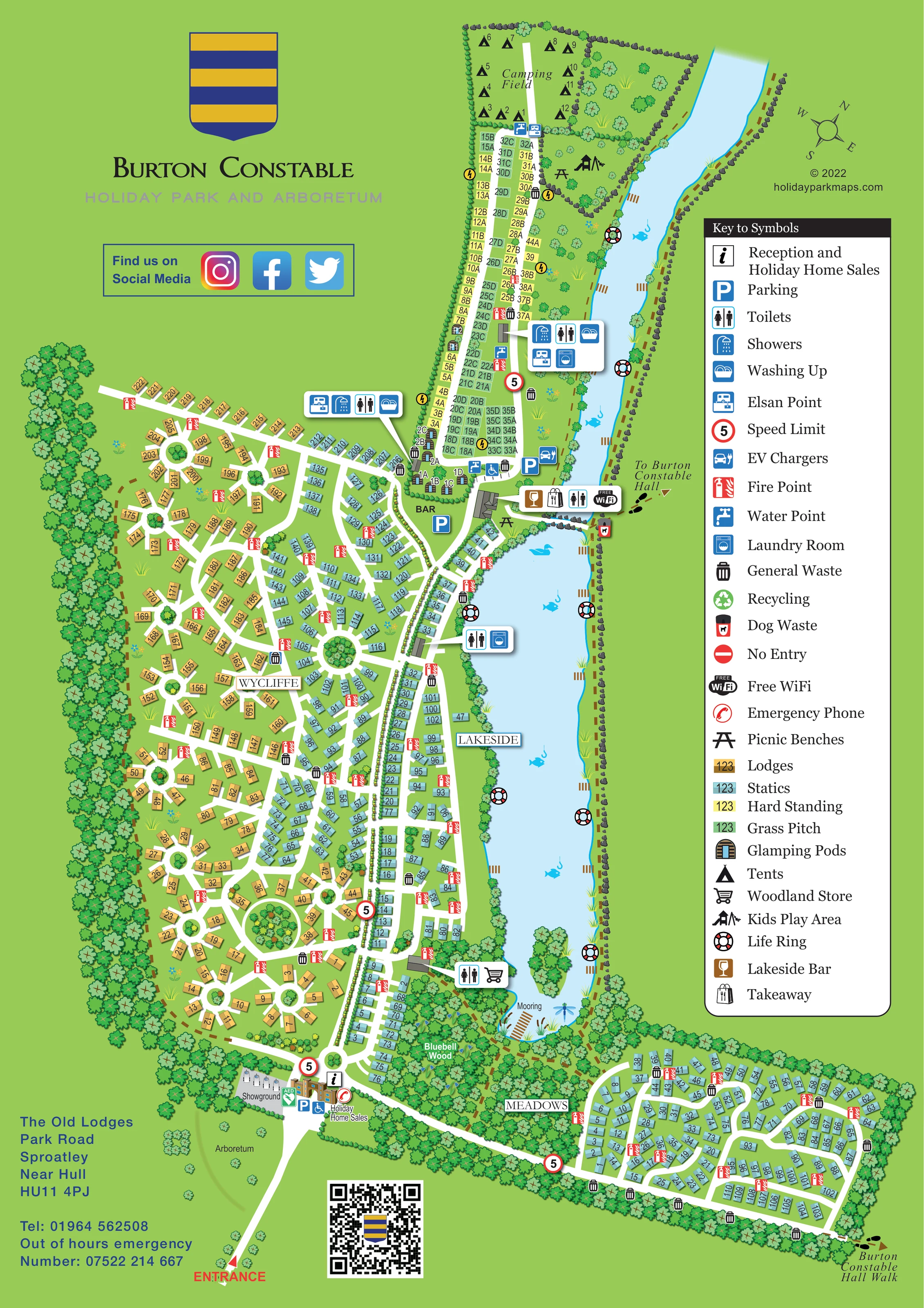
Two elongated blue water bodies dominate the eastern side of the main plan, with reed beds, trees, rock-edged banks and decorative fish and waterfowl.
ILLUSTRATED PARK MAP · P426
The Old Lodges, Park Road, Sproatley, Near Hull · United Kingdom
 Enlarge the map ↗
A SENSE OF THE PLACE
Burton Constable Holiday Park & Arboretum is based at The Old Lodges, Park Road, Sproatley, Hull. The holiday park occupies one hundred acres of countryside and woodland beside the Burton Constable estate. The park offers caravans and lodges, cottages, glamping, touring and camping, as well as holiday-home ownership.
On-site food and drink facilities include the Lakeside Bar, Parkland Kitchen and Woodland Store café and grocery shop. The thirty-acre arboretum contains over two hundred rare tree species and is free to explore.
LOOK CLOSER
Two elongated blue water bodies dominate the eastern side of the main plan, with reed beds, trees, rock-edged banks and decorative fish and waterfowl.
A dense woodland belt separates the main park from Meadows and surrounds the southern end of the lake.
A lightly planted area labelled Arboretum lies west of the entrance approach.
Continuous tree belts enclose much of the park, while circular tree-planted islands punctuate the western road network.
An information symbol and labelled holiday-home sales buildings form an arrival hub near the southern entrance.
Blue parking symbols identify spaces at the entrance, near the bar and beside the northern lakeside facilities.
An EV-charging symbol appears beside parking near the southern end of the touring strip.
Grouped amenity callouts identify toilets, showers and washing-up facilities around the touring area, with further toilet symbols by the bar, lakeside accommodation and store.
An information symbol and labelled holiday-home sales buildings form an arrival hub near the southern entrance.
Blue parking symbols identify spaces at the entrance, near the bar and beside the northern lakeside facilities.
An EV-charging symbol appears beside parking near the southern end of the touring strip.
Grouped amenity callouts identify toilets, showers and washing-up facilities around the touring area, with further toilet symbols by the bar, lakeside accommodation and store.
Touring service blocks include Elsan and laundry symbols; water-point symbols also appear within the touring strip.
The bar occupies the central lakeside hub between the touring area and the main accommodation sections.
A takeaway symbol is grouped with the bar, toilets and WiFi callout.
The shopping-trolley symbol identifies the store beside a building near the southern end of Lakeside, adjoining Bluebell Wood.
A Free WiFi symbol is shown in the bar-area facility callout; the artwork does not establish coverage across the entire park.
A playground pictogram appears in the wooded green space between the camping field and the northern lake.
Picnic-table symbols appear near the northern play area and beside the bar.
General-waste bins are distributed through accommodation areas; a dog-waste symbol is visible near the eastward route to Burton Constable Hall.
Recycling is included in the key, but a corresponding location is not clearly identifiable in the artwork.
Red fire-point symbols recur throughout the accommodation sections, life rings mark the lake edges, and an emergency-phone symbol appears at the entrance hub.
A green AED marker is shown beside the entrance buildings.
A small labelled showground lies beside the entrance and holiday-home sales area.
Two elongated blue water bodies dominate the eastern side of the main plan, with reed beds, trees, rock-edged banks and decorative fish and waterfowl.
A mooring is labelled at the southern tip of the larger lake, beside Bluebell Wood.
A dense woodland belt separates the main park from Meadows and surrounds the southern end of the lake.
A lightly planted area labelled Arboretum lies west of the entrance approach.
Continuous tree belts enclose much of the park, while circular tree-planted islands punctuate the western road network.
A clearly labelled southern entrance leads to reception and divides into the main park and the road towards Meadows.
Footprint symbols and dashed brown paths indicate a route east of the bar and the Burton Constable Hall Walk beyond Meadows.
Red-ringed 5 markers are placed at the entrance and selected internal road junctions.
A no-entry sign is defined in the legend, without a clearly identifiable mapped position.
Operator information names Parkland Kitchen among the park's food facilities; that name is not used on this artwork.
READING THE MAP
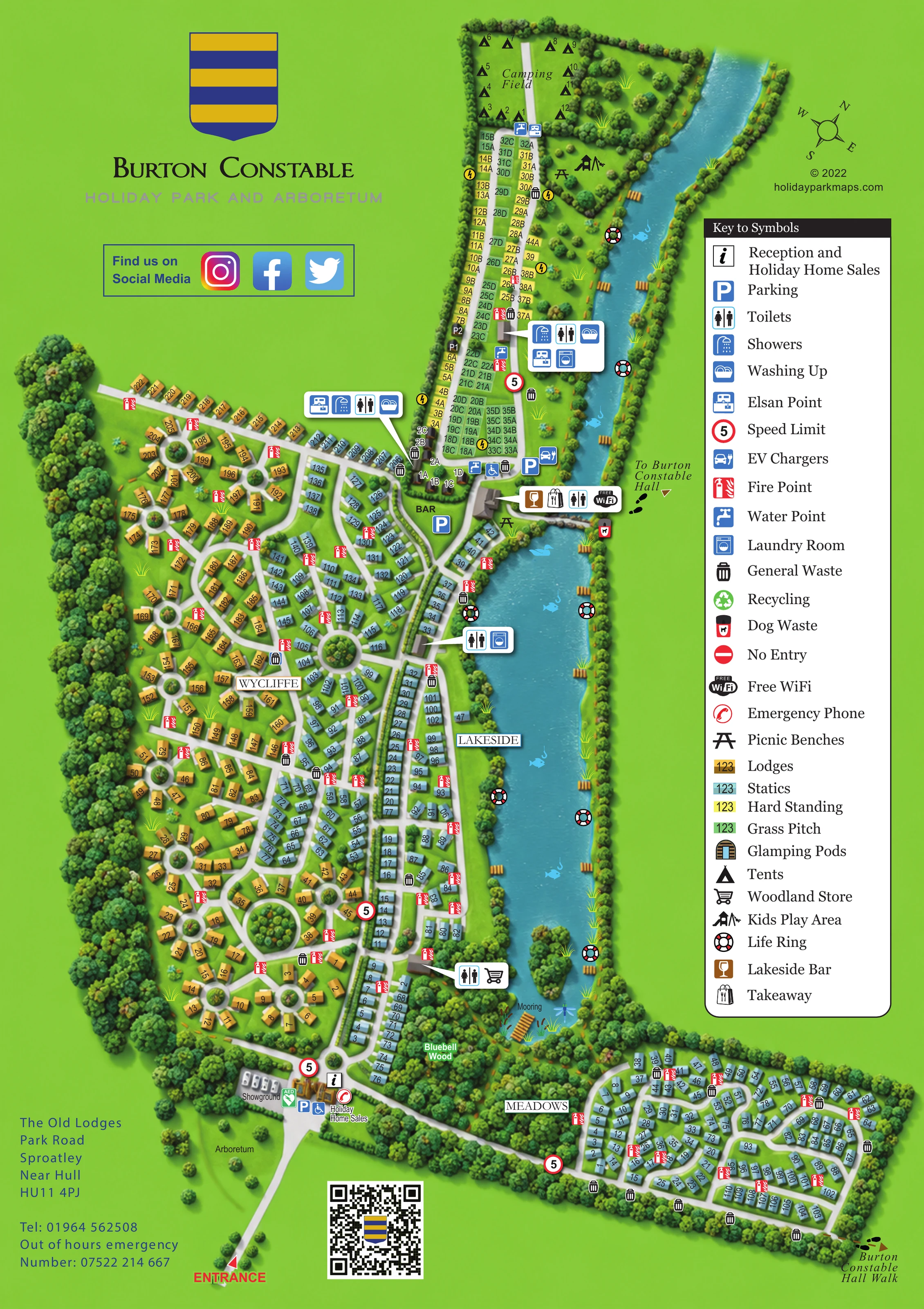
This illustrated map of Burton Constable Holiday Park & Arboretum brings a large, mixed-accommodation site into one coherent portrait plan. Set at Sproatley near Hull, the park is presented around two elongated lakes, woodland boundaries and a distinctive network of white internal roads. The water provides an immediate orientation point, while the named Wycliffe, Lakeside and Meadows areas help visitors understand how the different parts of the park connect.
Colour-coded accommodation is central to the design. Ochre lodges and pale-blue static caravans occupy the main residential areas, with yellow hard standings and green grass pitches forming a touring strip towards the top of the page. A camping field, glamping pods and children's play area add further variety without losing the overall structure.
The map also gives practical facilities a clear place in the landscape. Reception and holiday-home sales anchor the entrance, while the Lakeside Bar, Woodland Store and shared touring amenities appear in recognisable symbol groups. Bluebell Wood, the arboretum and routes towards Burton Constable Hall make this a useful example of mapping that combines pitch finding with a strong sense of setting.
The single-page plan is organised around a southern entrance and two lakes running along the eastern side of the main park. Reception, holiday-home sales, parking and a small showground form the arrival area. From here, white roads lead into the main accommodation network or turn east through a wooded corridor towards Meadows, a separate cluster of static caravans arranged around curved roads.
Wycliffe fills much of the western side. Its ochre lodge plots sit along branching lanes and around circular planted islands, with pale-blue statics extending through the central roads. Lakeside occupies the narrower strip beside the larger lake, giving the water a clear role as a wayfinding landmark. Bluebell Wood encloses the lake's southern tip, where a mooring is labelled and the Woodland Store is marked nearby.
At the northern end, tightly arranged grass and hard-standing pitches form a touring area. Glamping-pod symbols line part of its western edge, and a labelled camping field lies beyond. The adjacent green space contains a play-area pictogram and picnic bench. Enlarged amenity panels identify showers, toilets, washing-up facilities, Elsan disposal and laundry services, while smaller symbols mark water points, parking and EV chargers.
The bar sits at the junction between the touring area and the main park. Its callout combines the Lakeside Bar, takeaway, toilets and WiFi symbols. Fire points, waste bins and lakeside life rings provide further practical detail. Brown dashed paths and footprint markers indicate onward walks towards Burton Constable Hall.
A tall right-hand legend explains the accommodation colours and facility symbols. The accompanying detail view enlarges this same legend and adjacent lakeside artwork; it is not a separate park section or additional map variant.
 Enlarge this map ↗
KEEP EXPLORING
Chosen for shared landscapes, accommodation or facilities.
 Explore the map ↗
United Kingdom
Woodland park map with mixed pitches, bell tents, lodges and a fishing lake.
 Explore the map ↗
United Kingdom
Woodland holiday homes, named camping fields and farm buildings on a colour-coded Nether Wasdale park map.
 Explore the map ↗
United Kingdom
Illustrated caravan park plan with woodland and riverside walks, fishing pools and wildlife panels.
Features may come from the sample artwork, its key or published park information. Approximate numbers describe the drawing and may cover only part of a park. They are intended to help you compare map examples. Current facilities and booking information should be checked with the park.
TAKE A CLOSER LOOK
View the illustrated map in detail or choose a file to download. These are sample maps; contact the park for current visitor information.



LET’S MAP YOUR PARK
For a map quotation, find your park and draw a rough boundary around it. The area you select helps us work out the design time and price.
Draw your park for a quote ↗Or talk to our map designers
01751 473136
 burtonconstable_large.png