
Tree and shrub boundaries
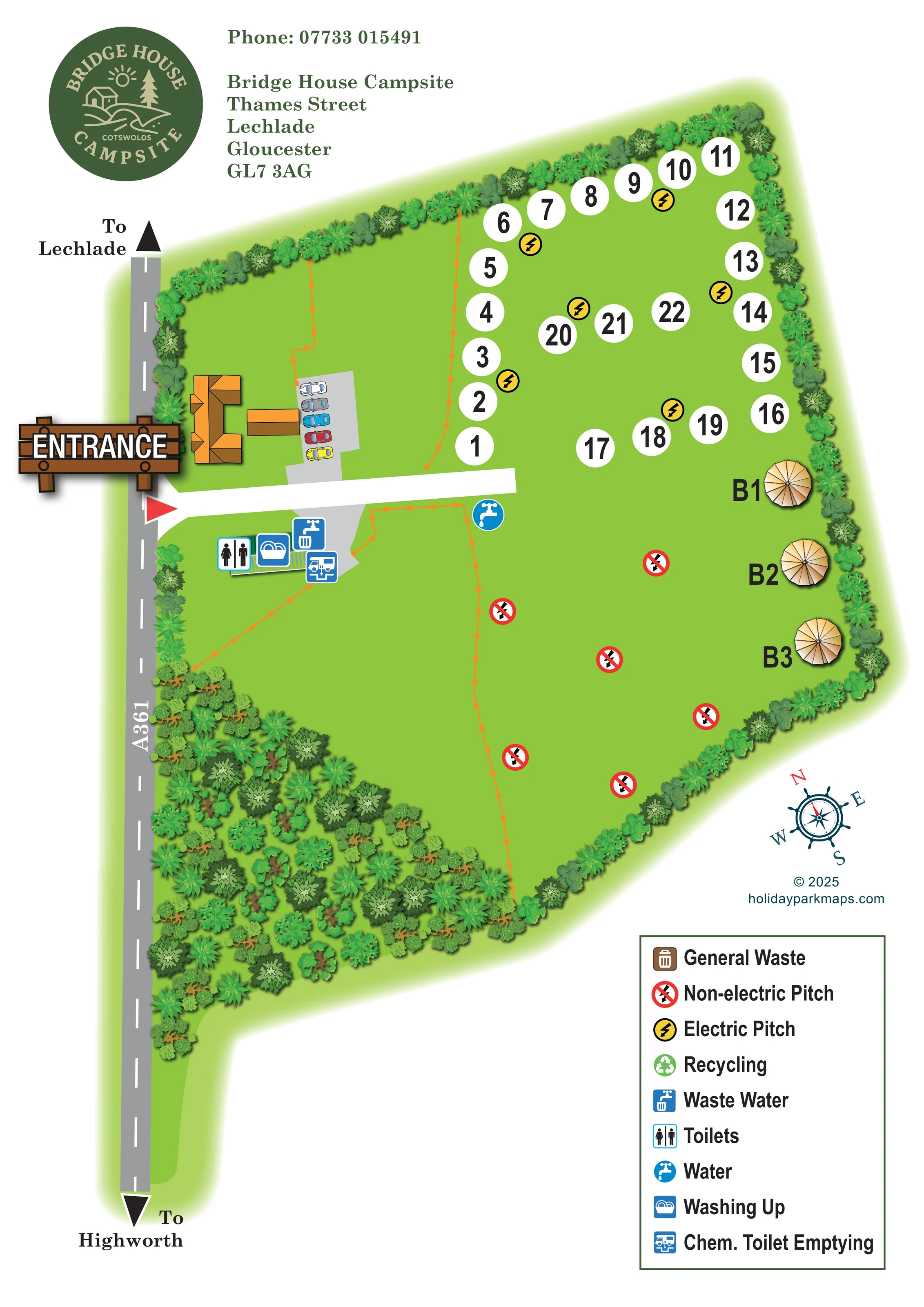
Layered trees and shrubs enclose the grass fields, with a particularly broad planted wedge along the lower-left roadside edge.
ILLUSTRATED PARK MAP · P036
Bridge House Campsite, Thames Street, Lechlade, Gloucester · United Kingdom
 Enlarge the map ↗
A SENSE OF THE PLACE
Bridge House Campsite is a small family-run touring site at Lechlade, close to the River Thames and the edge of the Cotswolds. It welcomes tents, caravans and motorhomes.
Electric connections, drinking water, hot showers, toilets and washing-up facilities support stays on site. Lechlade and riverside walks are close by, giving visitors opportunities to combine a camping break with time in the town and surrounding countryside.
LOOK CLOSER
Layered trees and shrubs enclose the grass fields, with a particularly broad planted wedge along the lower-left roadside edge.
Thin orange lines with regularly spaced square marks suggest fences or field divisions; their precise meaning is not defined by the legend.
A large illustrated timber ENTRANCE sign and red triangular marker identify the access from the A361 on the left side.
The roadside strip is labelled A361, with arrows towards Lechlade at the top and Highworth at the bottom.
A short white lane leads into the campsite between the upper numbered-pitch area and the lower camping field.
A grey hardstanding with a row of car illustrations sits beside the entrance buildings, above the internal access lane; it is not separately labelled.
A male-and-female toilet symbol identifies the service building just below the entrance lane.
A blue washing-up symbol is grouped with the toilets at the entrance-side service building.
A large illustrated timber ENTRANCE sign and red triangular marker identify the access from the A361 on the left side.
The roadside strip is labelled A361, with arrows towards Lechlade at the top and Highworth at the bottom.
A short white lane leads into the campsite between the upper numbered-pitch area and the lower camping field.
A grey hardstanding with a row of car illustrations sits beside the entrance buildings, above the internal access lane; it is not separately labelled.
A male-and-female toilet symbol identifies the service building just below the entrance lane.
A blue washing-up symbol is grouped with the toilets at the entrance-side service building.
A blue waste-water symbol appears in the service cluster beside the grey access apron.
The chemical toilet emptying symbol is positioned alongside the other entrance-side service facilities.
A blue circular tap symbol marks a water point just below the inner end of the access lane.
Yellow circles containing black lightning bolts identify the electric-pitch provision in the upper numbered field.
Red crossed-lightning symbols are dispersed across the lower grass field and explained as non-electric pitches in the legend.
A brown bin symbol is included in the legend, but no corresponding location is clearly identifiable on the plan.
A green recycling symbol is explained in the legend without a clearly identifiable position on the plan.
Layered trees and shrubs enclose the grass fields, with a particularly broad planted wedge along the lower-left roadside edge.
Thin orange lines with regularly spaced square marks suggest fences or field divisions; their precise meaning is not defined by the legend.
Hot showers are described in the park information but are not separately identified by a map symbol.
The park information places the campsite close to the River Thames and riverside walks. The river and walking routes are not drawn on this site plan.
READING THE MAP
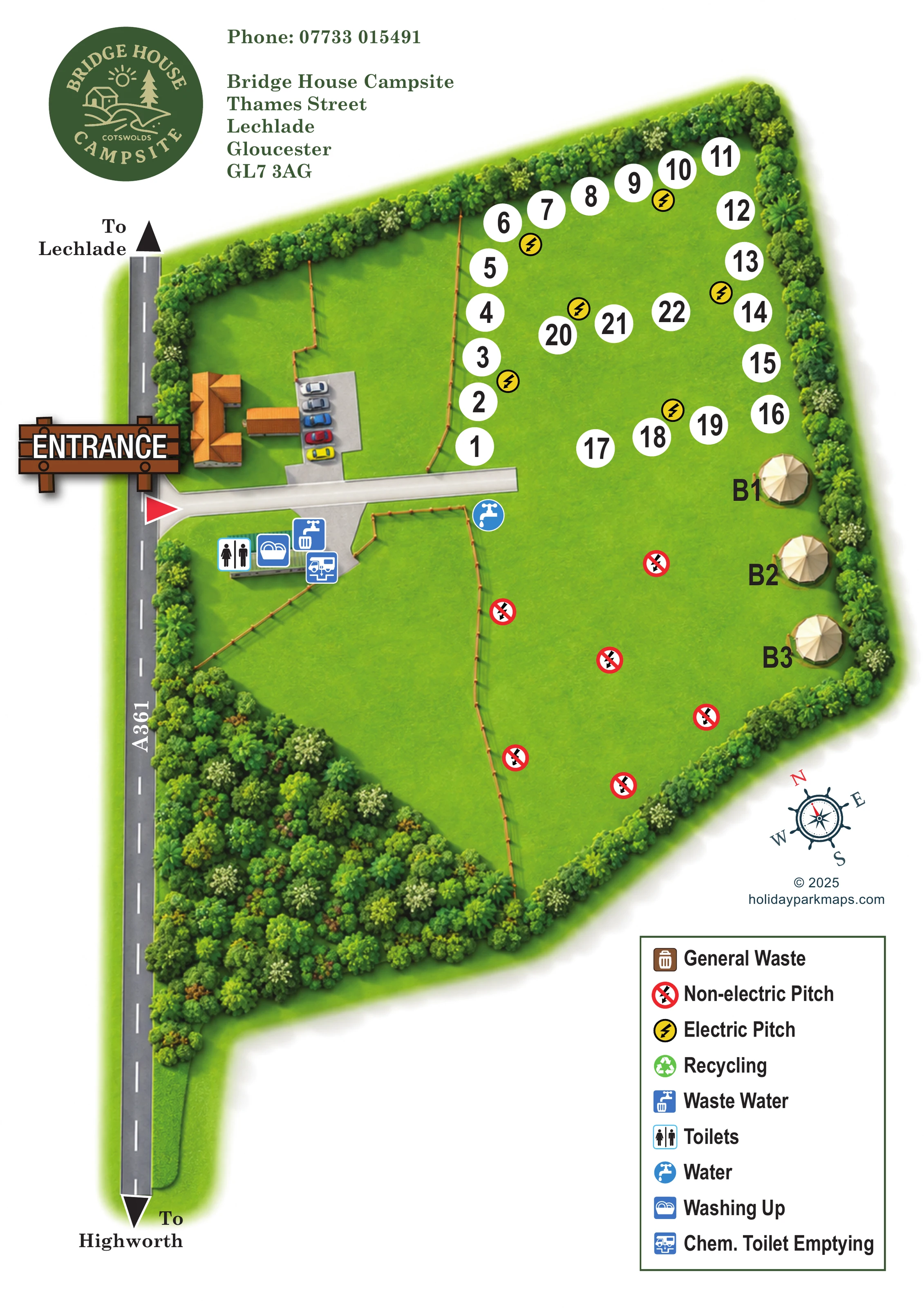
This illustrated map of Bridge House Campsite presents a small grass camping and touring site at Lechlade, close to the River Thames and the edge of the Cotswolds. Its layout centres on two contrasting accommodation areas: an upper field of numbered pitches with electric symbols, and a lower open field marked for non-electric camping. Three cream bell-tent-style illustrations add a distinctive accommodation group along the right-hand boundary.
The arrival point is deliberately prominent. A timber-style entrance sign sits beside the A361, where a short lane leads past illustrated buildings and parking to the campsite's service area. Toilets, washing-up facilities, water and disposal points are picked out in blue, keeping practical information easy to distinguish from the green landscape.
Dense tree and shrub illustrations give the plan a sheltered, leafy character, while large white pitch numbers remain visually clear against the grass. The circular campsite logo, contact block, compass and boxed legend complete a portrait design that combines a welcoming campsite identity with straightforward guest orientation.
The map is arranged around an irregular grass site bordered by illustrated trees and shrubs. Along the left edge, the A361 appears as a grey road with a dashed centre line, an arrow towards Lechlade at the top and another towards Highworth at the bottom. A large wooden entrance sign and red triangular marker draw attention to the access point. From here, a short white lane runs into the site, with orange-roofed buildings and an illustrated parking area above it.
Below the lane, a compact service building and grey apron carry symbols for toilets, washing up, waste water and chemical toilet emptying. A separate blue tap symbol marks water near the lane's inner end. These services are concentrated close to arrival rather than scattered through the accommodation fields.
The upper field contains roughly 20 numbered pitches, shown as bold black numbers in white discs. They follow the perimeter and short inner arcs, with yellow electric symbols between groups. In the lower field, dispersed red non-electric symbols indicate a broader camping area without defining individual pitch boundaries. Three labelled cream bell-tent-style units stand along the right-hand tree line. Thin orange, post-marked lines suggest internal divisions, while a substantial wedge of vegetation fills the lower-left boundary.
The single portrait artwork places its logo and contact details above the plan and a large boxed symbol key at the lower right. General waste and recycling are included in that key without clearly identifiable map positions. A nautical-style compass and designer credit sit between the plan and legend. Shaded foliage, radial tent roofs and the timber entrance sign supply illustrative character without competing with the main wayfinding labels.
 Enlarge this map ↗
KEEP EXPLORING
Chosen for shared landscapes, accommodation or facilities.
 Explore the map ↗
United Kingdom
Colour-coded campsite map with riverside pitches, bell tents, a swimming pool and fishing lake.
 Explore the map ↗
United Kingdom
Woodland park map with mixed pitches, bell tents, lodges and a fishing lake.
 Explore the map ↗
United Kingdom
Riverside park map with colour-coded pitches, static caravan groups and a comprehensive facilities key.
Features may come from the sample artwork, its key or published park information. Approximate numbers describe the drawing and may cover only part of a park. They are intended to help you compare map examples. Current facilities and booking information should be checked with the park.
LET’S MAP YOUR PARK
For a map quotation, find your park and draw a rough boundary around it. The area you select helps us work out the design time and price.
Draw your park for a quote ↗Or talk to our map designers
01751 473136