
Holding Field
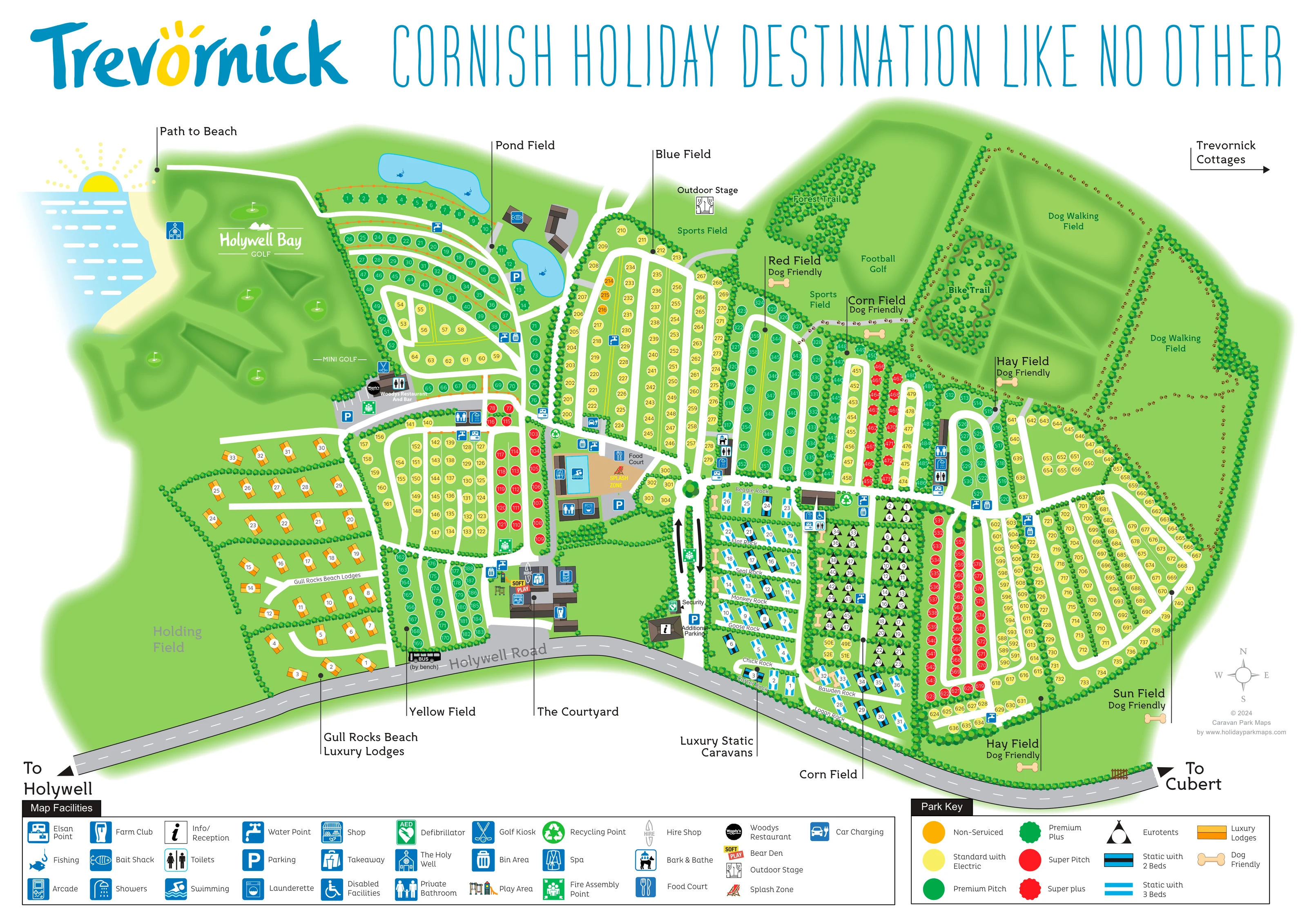
A large open area west of the lodge neighbourhood is labelled Holding Field.
ILLUSTRATED PARK MAP · P348
Holywell Bay, Cornwall · United Kingdom
 Enlarge the map ↗
A SENSE OF THE PLACE
Trevornick is a holiday park at Holywell Bay in Cornwall, offering touring, camping, prepared tents and self-catering accommodation. Caravans, lodges and cottages provide alternatives to bringing a camping setup.
Shared facilities include a swimming pool and spa, with entertainment and surfing activities also advertised. The park map helps visitors navigate the different accommodation areas and activity spaces within its coastal setting.
LOOK CLOSER
A large open area west of the lodge neighbourhood is labelled Holding Field.
Two expansive dog-walking fields occupy the upper-right landscape, with perimeter routes and tree-lined boundaries.
The Holy Well symbol appears on the western side near the illustrated coast and golf area.
A stylised sea, sandy edge and rising sun establish the coastal setting at the upper left without providing a detailed beach plan.
Reception is positioned beside the entrance from Holywell Road, with security labelled along the internal arrival spine.
Blue parking symbols mark several locations, including the central facilities, pond area, restaurant and additional parking beside reception.
The central leisure cluster includes a blue swimming pool and a labelled Splash Zone.
A spa symbol appears beside the central swimming and leisure buildings.
Reception is positioned beside the entrance from Holywell Road, with security labelled along the internal arrival spine.
Blue parking symbols mark several locations, including the central facilities, pond area, restaurant and additional parking beside reception.
A large open area west of the lodge neighbourhood is labelled Holding Field.
The central leisure cluster includes a blue swimming pool and a labelled Splash Zone.
A spa symbol appears beside the central swimming and leisure buildings.
The Food Court is labelled beside the pool complex, close to the main internal route.
Woodys occupies a separate western amenity node between the pitch fields and golf landscape.
The Farm Club symbol is positioned within the lower central Courtyard building group.
The Courtyard complex carries a colourful soft-play label corresponding to Bear Den in the facilities key.
An arcade symbol appears within the Courtyard facilities.
Shop and takeaway symbols identify services in the Courtyard building group.
A hire marker is shown by the Courtyard, using the surfboard-shaped symbol explained in the legend.
The Outdoor Stage is placed beside the northern sports field, away from the main building clusters.
Small illustrated playground symbols identify play spaces near the central leisure area and eastern accommodation.
Two labelled sports spaces sit along the northern edge of the main pitch fields.
A broad western golf landscape is illustrated with shaped greens and flag symbols under the Holywell Bay Golf name.
Mini golf is labelled near the western restaurant area, with a golf kiosk symbol nearby.
Football Golf occupies a large northern green area beside the sports fields and wooded trails.
Two blue ponds beside Pond Field contain fishing symbols, with the Bait Shack marked close to the lower pond.
Repeated sanitary symbols identify shared service points around the accommodation fields and amenity clusters.
The facilities key includes a wheelchair symbol labelled Disabled Facilities; no specific location is confidently resolved in this view.
Launderette symbols appear among the shared amenity points serving the pitch fields.
Water taps and Elsan symbols are distributed around the touring and camping fields.
Blue bin icons and green recycling symbols mark grouped waste facilities throughout the plan.
Car-charging symbols appear among the central service points and are explained in the facilities legend.
A dog-washing symbol is shown among the service icons near the eastern accommodation blocks.
Green safety symbols identify a defibrillator near the arrival area and several fire assembly points.
Two expansive dog-walking fields occupy the upper-right landscape, with perimeter routes and tree-lined boundaries.
Red, Corn, Hay and Sun fields carry dog-friendly labels or bone markers. These identify mapped areas rather than a park-wide policy.
A winding route through a compact northern woodland is labelled Forest Trail.
A looping trail is illustrated within a separate wooded area beside Football Golf.
A labelled departure point at the upper left directs visitors towards the beach.
The Holy Well symbol appears on the western side near the illustrated coast and golf area.
A stylised sea, sandy edge and rising sun establish the coastal setting at the upper left without providing a detailed beach plan.
Holywell Road curves across the lower edge, with arrows towards Holywell and Cubert.
A bus marker is labelled beside Holywell Road, with a note locating it by a bench.
A right-pointing arrow in the upper-right margin directs visitors to cottages outside the illustrated plan.
READING THE MAP
This illustrated map of Trevornick at Holywell Bay brings a large Cornish holiday park into one coherent visitor guide. Named camping and touring fields fill the centre and east of the plan, while Gull Rocks Beach lodges form a separate neighbourhood to the west. Blue static caravan symbols and black Eurotent markers distinguish other accommodation areas without competing with the numbered pitch system.
The surrounding landscape is an important part of the composition. Golf greens, fishing ponds, wooded trails and extensive dog-walking fields give the plan recognisable landmarks, while a small coastal illustration and a labelled beach path establish its seaside setting. Holywell Road provides a clear southern edge, with reception and the main internal route positioned close to it.
Facilities are spread across several hubs, including the Courtyard, the swimming and Food Court area, and Woodys Restaurant and Bar. Separate keys for facilities and accommodation help visitors interpret this busy plan, while Trevornick’s large blue-and-yellow branding gives the page a strong identity.
The plan is arranged around a curving stretch of Holywell Road, with directions to Holywell and Cubert at opposite ends. Reception, security and additional parking mark the main arrival area. From here, a white internal spine leads north towards the swimming pool, spa, Splash Zone and Food Court, while smaller lanes branch into the accommodation fields.
Pond, Yellow and Blue fields occupy much of the western and central pitch layout. Red, Corn, Hay and Sun fields extend across the eastern side, several carrying dog-friendly labels and bone symbols. Coloured numbered circles distinguish six pitch grades, including standard electric, premium and super categories. Orange lodge rectangles occupy Gull Rocks Beach to the west; blue static caravans sit in rock-named rows near the road, beside a distinct block of triangular Eurotent markers.
The Courtyard groups the Farm Club, Bear Den soft play, arcade, shop, takeaway and hire facilities near the entrance. Woodys Restaurant and Bar forms another destination farther west. Repeated pictograms locate toilets, showers, water, Elsan points, laundry, bins and recycling across the fields, with parking and safety markers providing additional orientation.
Beyond the accommodation, the artwork gives generous space to Holywell Bay Golf, mini golf, two fishing ponds, sports fields and Football Golf. Separate wooded areas contain the Forest Trail and Bike Trail, and two large dog-walking fields occupy the upper-right landscape. A beach-path label and Holy Well symbol appear on the coastal side; a marginal arrow points towards Trevornick Cottages. The bottom of the page holds two complementary keys, leaving the illustrated site itself available for routes, numbered symbols and destination labels.
KEEP EXPLORING
Chosen for shared landscapes, accommodation or facilities.
 Explore the map ↗
United Kingdom
A colour-zoned coastal park map with touring areas, woodland trails, ponds and a leisure club.
 Explore the map ↗
United Kingdom
A woodland estate park map combining caravan loops, touring pitches, riverside paths and Bruce’s Cave landmarks.
 Explore the map ↗
United Kingdom
Woodland-framed Barnsoul map with mixed accommodation, shared facilities and paw-marked walking routes.
Features may come from the sample artwork, its key or published park information. Approximate numbers describe the drawing and may cover only part of a park. They are intended to help you compare map examples. Current facilities and booking information should be checked with the park.
TAKE A CLOSER LOOK
View the illustrated map in detail or choose a file to download. These are sample maps; contact the park for current visitor information.



LET’S MAP YOUR PARK
For a map quotation, find your park and draw a rough boundary around it. The area you select helps us work out the design time and price.
Draw your park for a quote ↗Or talk to our map designers
01751 473136
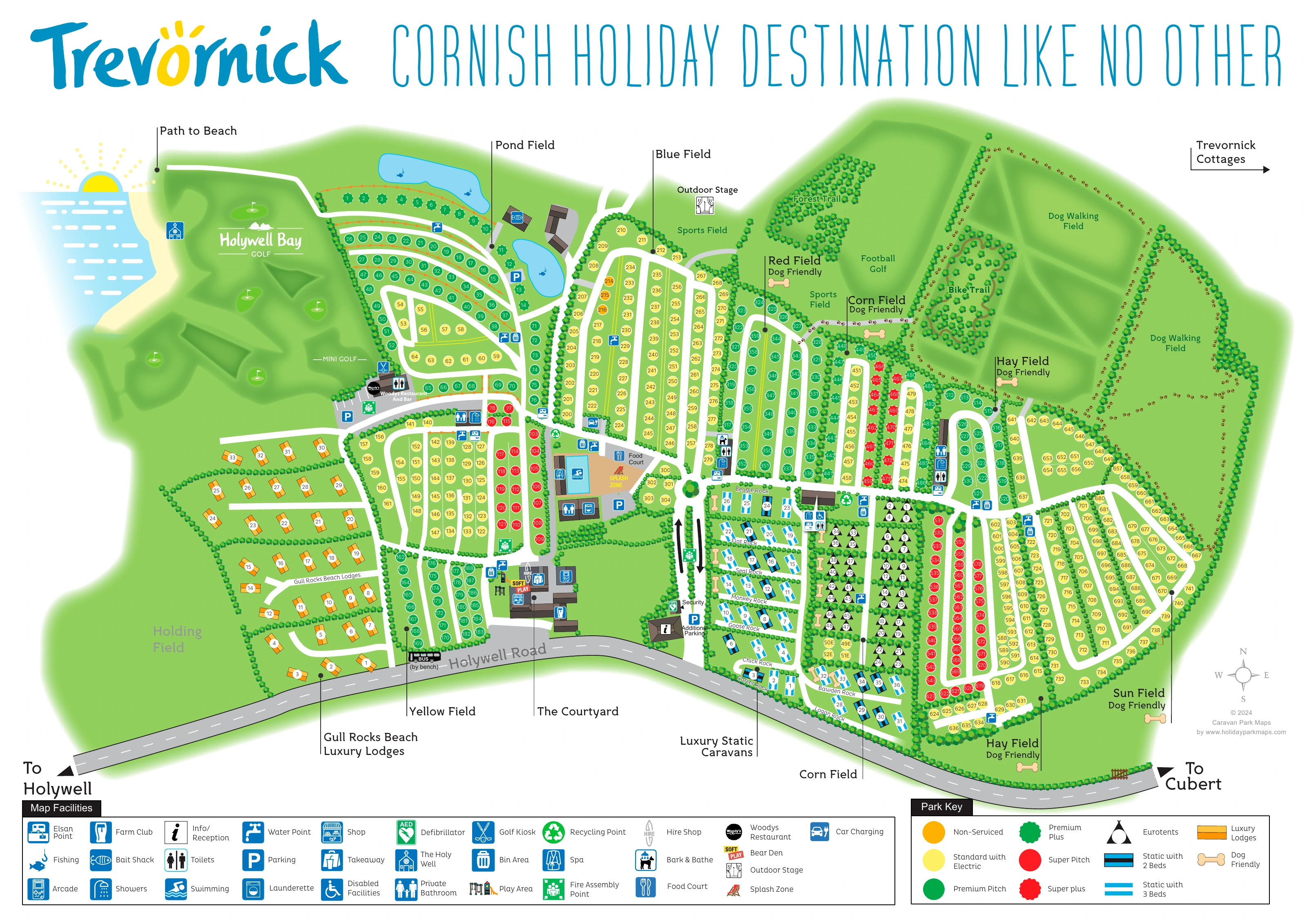
 trevornickmap_large.png