
Central lake and wooded island
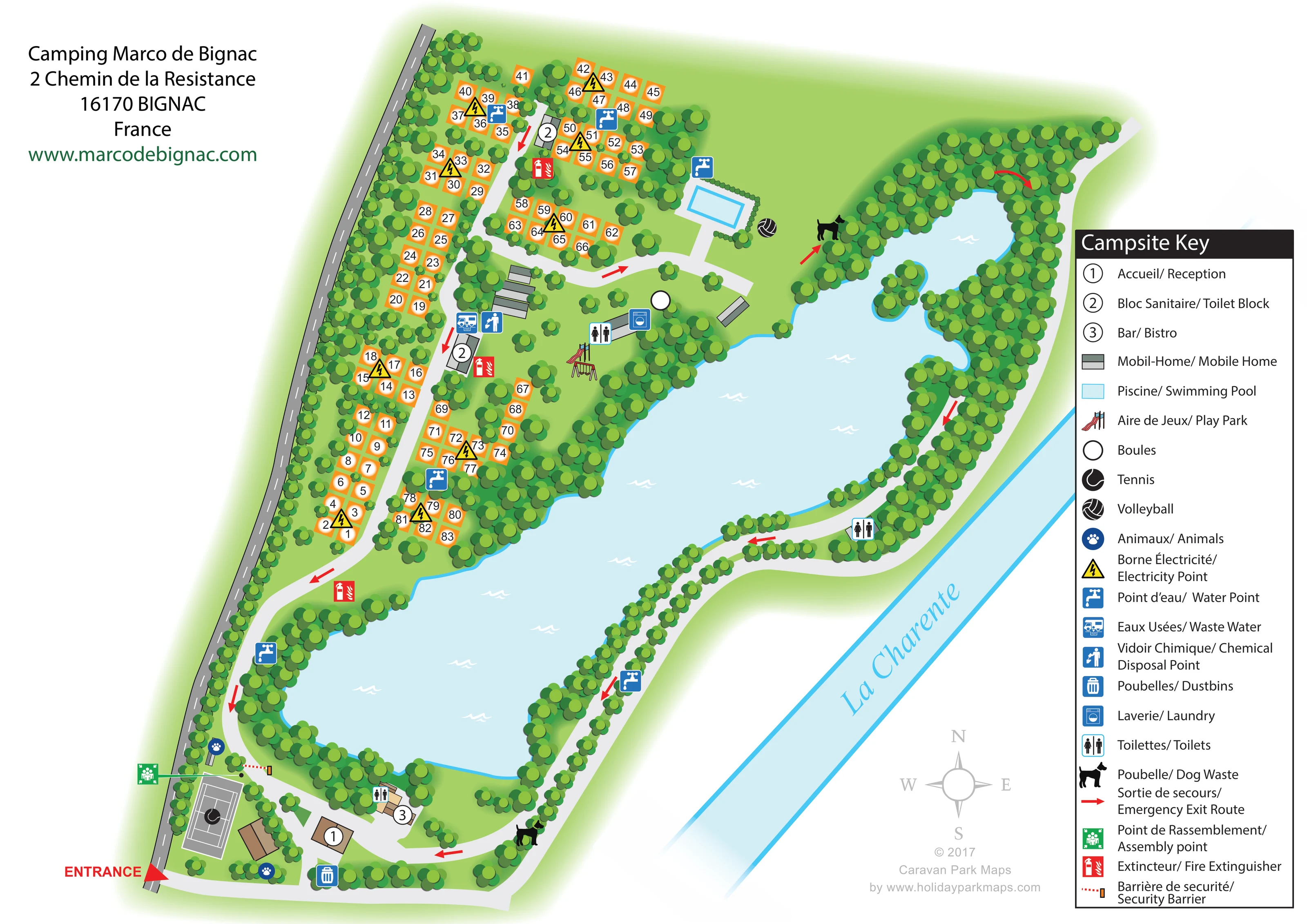
An elongated, irregular lake dominates the plan, with a small tree-covered island towards its northern end and densely planted banks.
ILLUSTRATED PARK MAP · P435
2 Chemin de la Résistance, Bignac · France
 Enlarge the map ↗
A SENSE OF THE PLACE
Camping Marco de Bignac is a lakeside campsite in the Charente region of France. Trees, shrubs and park-like grounds surround a lake where fishing is described as part of the visitor experience.
The setting offers space for camping, sports and outdoor recreation. Its map provides an overview of the camping areas and their relationship to the lake, helping visitors get their bearings around this waterside site.
LOOK CLOSER
An elongated, irregular lake dominates the plan, with a small tree-covered island towards its northern end and densely planted banks.
The river is labelled along the south-eastern side, outside the campsite's lakeside route.
Dense tree belts frame the road, lake and outer boundaries, with scattered trees separating pitch groups and recreation areas.
A large red entrance arrow marks access from the road at the south-western corner.
Pale grey routes connect the entrance facilities, western pitch areas and central recreation space, continuing around the lake's eastern bank.
Building marker 1 identifies reception close to the entrance.
Building marker 3 identifies the bar/bistro beside the southern shore, a short way inside the entrance.
Two numbered sanitary blocks serve the main pitch areas; additional toilet symbols appear by the central facilities, bar/bistro and eastern lakeside route.
An elongated, irregular lake dominates the plan, with a small tree-covered island towards its northern end and densely planted banks.
The river is labelled along the south-eastern side, outside the campsite's lakeside route.
Dense tree belts frame the road, lake and outer boundaries, with scattered trees separating pitch groups and recreation areas.
A large red entrance arrow marks access from the road at the south-western corner.
Pale grey routes connect the entrance facilities, western pitch areas and central recreation space, continuing around the lake's eastern bank.
Building marker 1 identifies reception close to the entrance.
Building marker 3 identifies the bar/bistro beside the southern shore, a short way inside the entrance.
Two numbered sanitary blocks serve the main pitch areas; additional toilet symbols appear by the central facilities, bar/bistro and eastern lakeside route.
A blue washing-machine symbol marks laundry beside the central toilet facilities.
A rectangular blue pool with a pale surround and hedge edging sits north of the central recreation area.
An illustrated slide and swing structure marks the play area between the central facilities and the lake.
A white circular marker identifies boules near the central laundry and recreation area.
A drawn court with white line markings and a tennis-ball symbol sits beside the entrance.
A volleyball symbol marks an activity location beside the pool and northern lake bank.
Blue tap symbols are distributed among the pitch groups, by the pool and along the lakeside routes.
Yellow lightning triangles identify shared electricity points within the numbered pitch clusters.
Separate blue symbols for waste water and chemical disposal sit beside the central-western sanitary block.
A blue dustbin marker is shown near reception and the southern access lane.
Black dog silhouettes, defined in the key as dog-waste points, appear at northern and southern lakeside locations.
Blue paw symbols labelled 'Animaux / Animals' mark locations near the entrance and tennis court; their precise function is not specified.
Red arrows, identified by the key as emergency exit routes, follow internal lanes and lakeside routes.
A green assembly-point symbol with a leader line marks a location beside the tennis court.
Red extinguisher symbols are grouped along the western pitch-access route and beside the sanitary blocks.
A dotted red barrier symbol crosses the internal lane just beyond the entrance recreation area.
The park context describes fishing as part of the lake's visitor experience; no fishing positions are marked on the artwork.
READING THE MAP
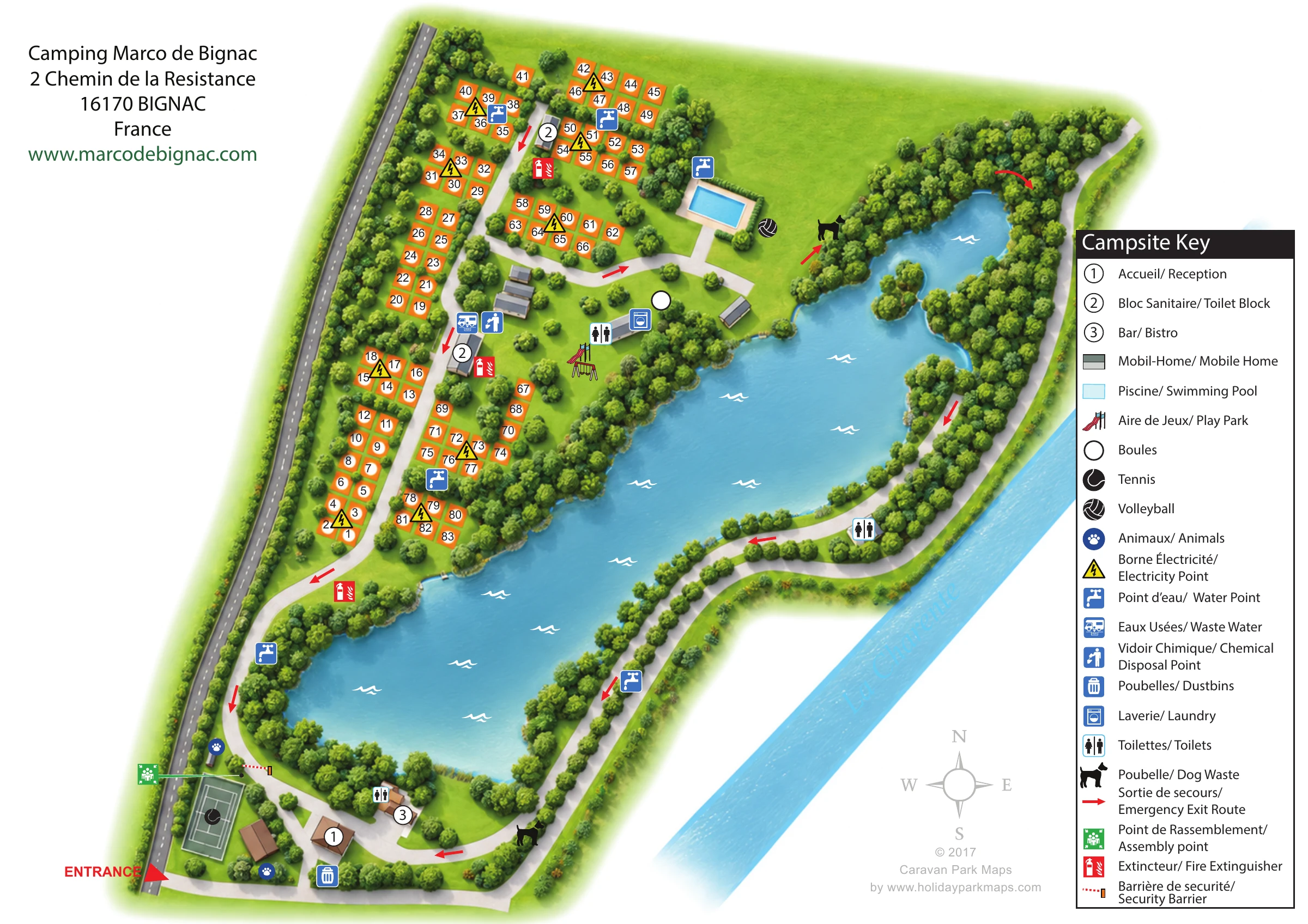
This illustrated map of Camping Marco de Bignac presents a tree-lined campsite in Bignac, in France's Charente region. A long, irregular lake forms the centre of the composition, with the River Charente shown separately along the south-eastern edge. Orange numbered pitches sit mainly between the lake and the western boundary road, making the relationship between accommodation, water and access easy to understand.
The map brings together campsite orientation and practical visitor information. Reception, the bar/bistro and tennis court are grouped near the entrance, while the swimming pool, play park, boules and volleyball occupy the central and northern grounds. A small number of mobile homes are distinguished from the numbered pitches using grey building symbols.
A substantial French/English key explains the facilities, utility points and safety markings. Blue service icons, yellow electricity symbols and red emergency-route arrows remain visually distinct from the green landscape. This sample is useful for campsites that need to show both the character of a waterside setting and the everyday details visitors need to find their way around.
The single landscape-format plan places the campsite diagonally across the page, with the entrance at the lower-left corner and the northern end of the lake towards the upper right. A dark grey external road defines the western edge. Inside the site, broad pale-grey lanes link the arrival area to the pitch groups, central facilities and lakeside routes.
The accommodation is shown as roughly 80 numbered campsite pitches, with a handful of separate mobile homes. Orange pitch rectangles form paired rows along the western lane and smaller blocks nearer the water. Large black numbers sit within white centres, while trees divide the clusters and soften their edges. Grey mobile-home symbols are concentrated around the central access branch.
Reception and the bar/bistro use numbered markers near the entrance and southern shore. Two sanitary blocks serve the main accommodation area, with further toilet symbols around the grounds. The central facilities include laundry, a play structure and boules; the rectangular swimming pool and volleyball marker sit farther north. A fully drawn tennis court makes the entrance recreation area particularly recognisable. Water points, electricity points, dustbins, waste-water disposal and chemical disposal are also marked.
The lake is illustrated with a cyan shoreline, white wave marks and a small wooded island. Dense green tree canopies follow its banks, especially along the eastern route. Beyond this, a separate blue band carries the name La Charente. Red emergency-exit arrows, extinguisher symbols, a green assembly point and a security barrier add operational information without replacing the main visitor layout.
The right-hand bilingual key explains the symbols, while the upper-left address block and lower-right compass complete the composition.
 Enlarge this map ↗
KEEP EXPLORING
Chosen for shared landscapes, accommodation or facilities.
 Explore the map ↗
United Kingdom
Illustrated caravan park plan with woodland and riverside walks, fishing pools and wildlife panels.
 Explore the map ↗
United Kingdom
A lakeside holiday-park and fishery map with numbered accommodation, fishing positions and clearly grouped visitor services.
 Explore the map ↗
United Kingdom
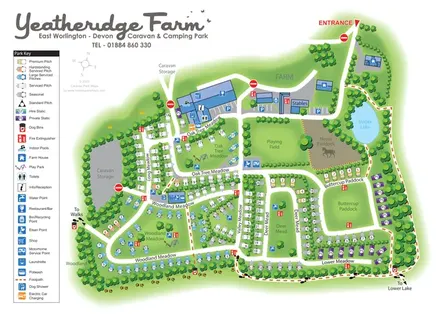
Colour-coded pitches, farm facilities and lakeside walking connections at Yeatheridge Farm, Devon.
Features may come from the sample artwork, its key or published park information. Approximate numbers describe the drawing and may cover only part of a park. They are intended to help you compare map examples. Current facilities and booking information should be checked with the park.
TAKE A CLOSER LOOK
View the illustrated map in detail or choose a file to download. These are sample maps; contact the park for current visitor information.


LET’S MAP YOUR PARK
For a map quotation, find your park and draw a rough boundary around it. The area you select helps us work out the design time and price.
Draw your park for a quote ↗Or talk to our map designers
01751 473136