
Burn of Fochabers
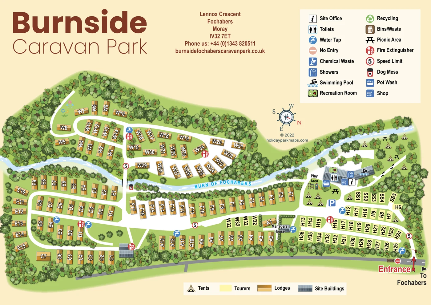
A pale-blue watercourse with white water-texture strokes runs through the plan, separating the W group from the lower lodge rows and continuing beside the camping area.
ILLUSTRATED PARK MAP · P051
Keith Road, Fochabers, Moray · United Kingdom
 Enlarge the map ↗
A SENSE OF THE PLACE
Burnside Caravan Park is based at Keith Road, Fochabers, Moray. The park is a family-run site in woodland on the outskirts of Fochabers. The Alan Rogers listing describes fully serviced touring pitches with TV connections. Tents are described as using a separate area, with electricity available.
The tourism-board listing describes a communal hall used for bingo, social nights and events. The listing describes a heated sanitary block with showers and a separate accessible wet room with washbasin and WC.
LOOK CLOSER
A pale-blue watercourse with white water-texture strokes runs through the plan, separating the W group from the lower lodge rows and continuing beside the camping area.
A mapped crossing connects the accommodation on opposite sides of the burn. Its construction, loading and accessibility are not stated.
Repeated illustrated tree crowns and shrubs frame the site, watercourse and accommodation rows. They communicate a leafy setting but do not establish precise tree positions, species or canopy cover.
Green open spaces surround the camping symbols, picnic tables and play area. No measured recreational area is stated.
Small colourful flower illustrations embellish the W-group lawn. These are decorative motifs rather than evidence of a named garden facility.
An information symbol keyed as Site Office is placed at the main amenities building. Its precise doorway is not identified.
Toilets are marked at the main amenities building. Heating and a separate accessible wet room are described only in the supplied catalogue research.
A shower facility is located by symbol at the amenities building. The artwork does not state opening arrangements or accessibility.
An information symbol keyed as Site Office is placed at the main amenities building. Its precise doorway is not identified.
Toilets are marked at the main amenities building. Heating and a separate accessible wet room are described only in the supplied catalogue research.
A shower facility is located by symbol at the amenities building. The artwork does not state opening arrangements or accessibility.
The supplied research describes a separate accessible wet room with washbasin and WC. No distinct accessible-facility symbol or room location is shown on the map.
The shop is identified by a shopping-trolley symbol at the amenities hub.
A swimming-pool symbol is explicitly placed on a wing of the amenities building. This establishes a depicted facility, not its current availability.
A recreation room is located using a billiard-table pictogram. The pictogram should not be treated as a full inventory of available games.
Supplied tourism-board research describes a communal hall used for bingo, social nights and events. It may correspond to a mapped building or recreation room, but that relationship is not established.
A labelled play area is illustrated with swings and a slide/climbing structure.
Dishwashing is marked by the Pot Wash symbol beside the amenities building.
Picnic-table symbols identify outdoor picnic locations among the camping areas and beside the amenities hub.
Water-tap points are distributed through the lodge and touring areas. The map does not state that every pitch has an individual connection.
Chemical-waste disposal is included in the facilities key, but no matching marker was confidently located in the primary plan.
Recycling is included in the key without a confidently located matching marker in the main plan.
General bins/waste are listed in the facilities key. This is separate from the dog-waste bin that is located on the plan.
A dog-waste bin is shown near the bridge. It does not establish the park's current pet policy or a designated dog-walking area.
Fire-extinguisher points are indicated by red symbols in several accommodation areas. The artwork is not current emergency guidance.
Circular speed-limit signs display 5. No unit of speed is printed in the key.
A no-entry symbol and a gate are drawn on the grey boundary road just left of the main entrance junction.
A parking area is identified by a blue P, although parking is not included in the upper facilities key.
A grey-roofed building is explicitly labelled Managers House. It is separate from the gold A1 lodge symbol and is excluded from accommodation counts.
An additional grey-roofed site building is drawn without a stated function. It should not be assumed to be accommodation or a washroom.
Fully serviced touring pitches with TV connections are described by the supplied catalogue research. The map does not identify individual service connections.
Electricity for tents is described in supplied research but is not shown by hook-up symbols on the artwork.
A pale-blue watercourse with white water-texture strokes runs through the plan, separating the W group from the lower lodge rows and continuing beside the camping area.
A mapped crossing connects the accommodation on opposite sides of the burn. Its construction, loading and accessibility are not stated.
Repeated illustrated tree crowns and shrubs frame the site, watercourse and accommodation rows. They communicate a leafy setting but do not establish precise tree positions, species or canopy cover.
Green open spaces surround the camping symbols, picnic tables and play area. No measured recreational area is stated.
Small colourful flower illustrations embellish the W-group lawn. These are decorative motifs rather than evidence of a named garden facility.
READING THE MAP
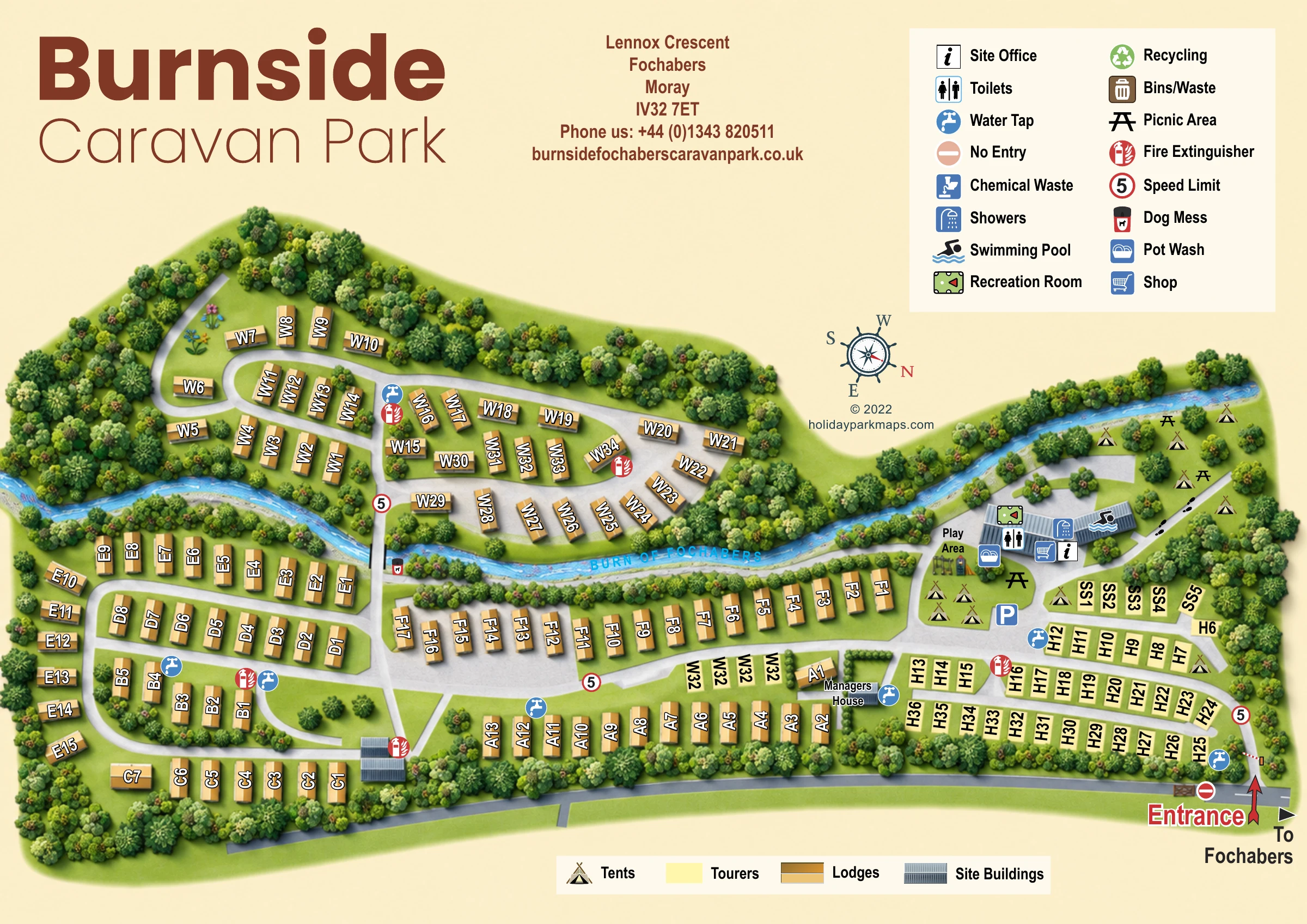
Burnside Caravan Park’s illustrated map uses the Burn of Fochabers as a strong feature running through the site. The Moray park is shown with lodge groups, touring pitches and camping spaces connected by internal roads and a bridge. Lettered accommodation rows help visitors distinguish different parts of the layout.
Trees, the stream and the arrangement of the roads give the sample a recognisable setting, while the pitch labels provide detailed wayfinding. The artwork marks a site office, shop, recreation room, play area, picnic spaces and parking, together with everyday facilities such as water taps and pot washing. The different accommodation symbols make it easy to see how the lodge, touring and tent areas relate to one another.
This is a useful example for established mixed parks with several accommodation zones and a landscape feature running through the site. It demonstrates how a detailed plan can combine a natural setting with practical visitor information, without making every part of the map look the same.
This landscape-format map presents Burnside Caravan Park as an elongated, tree-framed site arranged around the Burn of Fochabers. A large brown title dominates the upper left, with a centrally placed address, telephone number and printed website. The upper-right corner contains a two-column facilities key, while a separate strip along the bottom explains tents, tourers, lodges and site buildings.
The plan is drawn primarily from overhead. Gold roof symbols identify the accommodation called lodges in the key; pale-yellow rectangles distinguish touring positions, and small illustrated tents mark camping spaces. Lodge labels use white lettering with black outlines, rotated to follow each building. Touring labels are black on yellow. Grey, ridged roofs set the main amenities building, manager's house and another site building apart from accommodation.
The pale-blue burn winds through the centre with white water-texture strokes and a prominent blue name. A bridge links the upper W-labelled lodge group to the lower park. White internal routes form loops and branching lanes through the accommodation, contrasting with the grey boundary road. At the lower right, a large red entrance arrow, a striped barrier and a direction towards Fochabers establish the arrival point. A decorative compass shows that the artwork is not north-up; no scale is given.
The right-hand amenities hub brings together symbols for the site office, shop, toilets, showers, pot wash, recreation room and swimming pool. Nearby are illustrated play equipment, picnic tables, parking and a footprint-marked path towards the riverside camping spaces. Water taps, fire-extinguisher points and a dog-waste bin are distributed elsewhere on the plan.
Layered tree crowns, shrubs, soft shadows and occasional flower motifs give the map a leafy, welcoming character. The artwork carries a © 2022 designer credit. Before operational reuse, the repeated W32 labels on a short touring row and foliage overlapping some pitch codes merit checking. The facility symbols document what the artwork depicts, not confirmed current provision.
 Enlarge this map ↗
KEEP EXPLORING
Chosen for shared landscapes, accommodation or facilities.
 Explore the map ↗
United Kingdom
Colour-coded pitches, named log cabins and a woodland trail at Alpine Grove, Somerset.
 Explore the map ↗
United Kingdom
A colour-zoned coastal park map with touring areas, woodland trails, ponds and a leisure club.
 Explore the map ↗
United Kingdom
Illustrated Anglesey park map with static caravans, touring loops, camping, sports courts and a perimeter dog walk.
Features may come from the sample artwork, its key or published park information. Approximate numbers describe the drawing and may cover only part of a park. They are intended to help you compare map examples. Current facilities and booking information should be checked with the park.
LET’S MAP YOUR PARK
For a map quotation, find your park and draw a rough boundary around it. The area you select helps us work out the design time and price.
Draw your park for a quote ↗Or talk to our map designers
01751 473136