
Woodland and planted boundaries
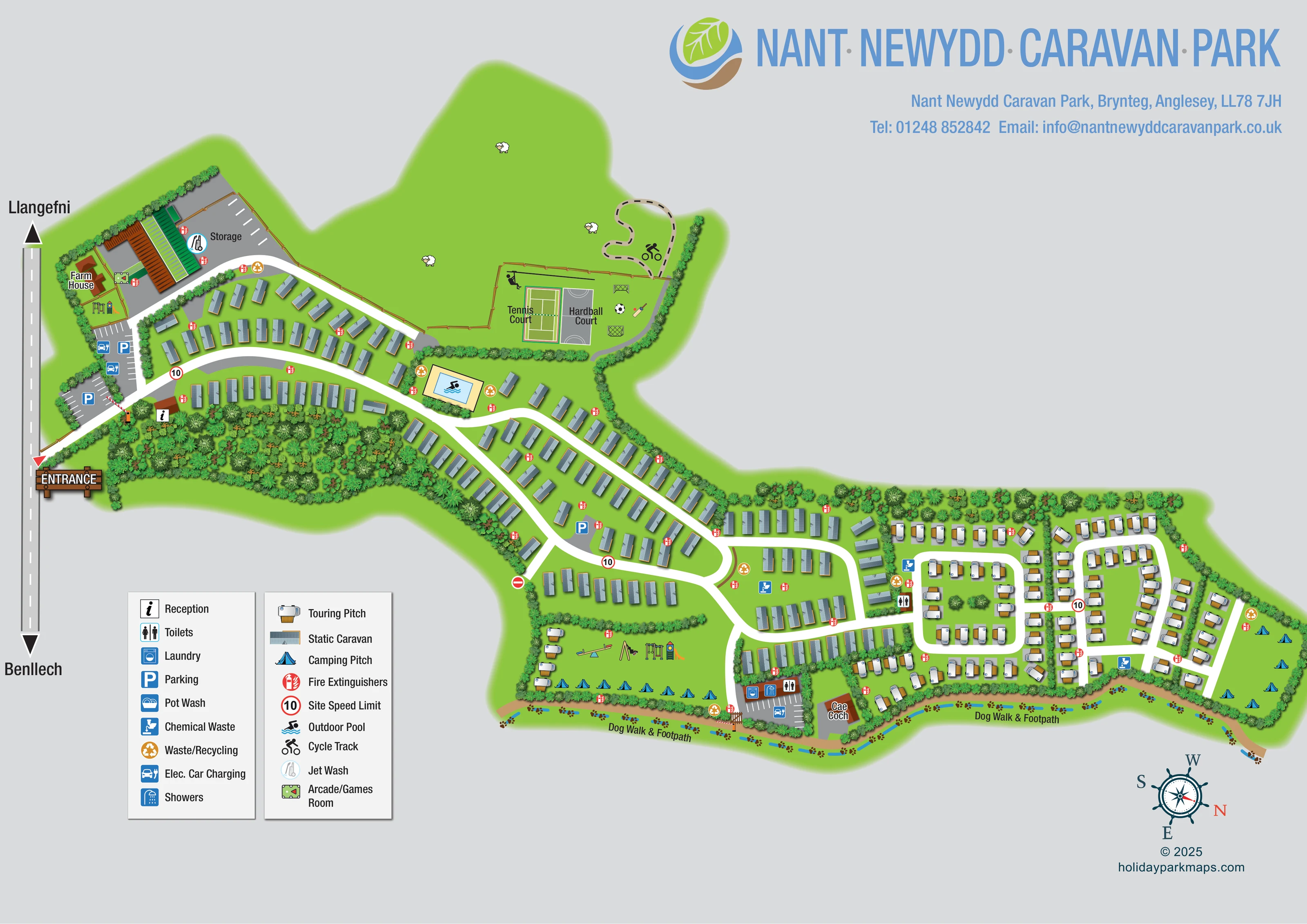
A dense wooded belt borders the entrance-side caravans, while repeated trees and hedges enclose the park and divide its accommodation areas.
ILLUSTRATED PARK MAP · P223
Nant Newydd Caravan Park, Brynteg, Anglesey · United Kingdom
 Enlarge the map ↗
A SENSE OF THE PLACE
Nant Newydd is a family-owned caravan park at Brynteg near Benllech on Anglesey. Holiday home and lodge accommodation sits alongside touring and camping provision.
An outdoor heated pool, tennis court, play areas and sports spaces provide activities on site. The touring and camping field is sheltered by hedgerows, with countryside views and the beaches of Anglesey nearby.
LOOK CLOSER
A dense wooded belt borders the entrance-side caravans, while repeated trees and hedges enclose the park and divide its accommodation areas.
An expansive green area above the accommodation contains decorative sheep, establishing a rural setting without implying an additional visitor facility.
An information symbol identifies the small reception building just inside the entrance, beside the wooded area.
Marked parking bays lie near the entrance and the lower amenity block, with electric car charging symbols in both areas. A further parking symbol appears among the central caravans.
The lower amenity building is marked with laundry, showers and toilets; another toilet point appears beside the touring loops.
Blue disposal symbols identify points in the central accommodation area and around the touring section.
Orange recycling symbols are distributed near the storage yard, pool, accommodation areas and camping fields.
Repeated red extinguisher symbols provide a consistent safety-point layer across the park.
An information symbol identifies the small reception building just inside the entrance, beside the wooded area.
Marked parking bays lie near the entrance and the lower amenity block, with electric car charging symbols in both areas. A further parking symbol appears among the central caravans.
The lower amenity building is marked with laundry, showers and toilets; another toilet point appears beside the touring loops.
Pot wash is included in the key, but its position is not clearly identifiable in the artwork.
Blue disposal symbols identify points in the central accommodation area and around the touring section.
Orange recycling symbols are distributed near the storage yard, pool, accommodation areas and camping fields.
Repeated red extinguisher symbols provide a consistent safety-point layer across the park.
A blue rectangular pool with a pale surround forms a prominent landmark between the entrance-side caravans and the recreation grounds.
A labelled green tennis court with white line markings sits in the fenced upper recreation area.
A labelled grey hardball court adjoins the tennis court.
Goal symbols, a football and cricket equipment identify a grass sports area beside the courts; an additional play-equipment silhouette appears along its upper edge.
A small sinuous circuit, outlined with a black dashed line and a cyclist symbol, sits beyond the sports grounds.
Play equipment is illustrated beside the farmhouse and in the lower grass field, where swings, a seesaw and a slide create a recognisable recreation landmark.
The key's games-room symbol is placed beside the farmhouse and storage buildings.
A jet-wash symbol is positioned in the storage-yard area.
A labelled grey yard with bay markings and long roofed buildings occupies the upper-left end of the park.
The Farm House is labelled beside the storage yard. Cae Coch identifies a separate brown-roofed building near the lower amenity block; no specific visitor function is stated.
A tan perimeter route runs along the lower edge of the park, labelled Dog Walk & Footpath and decorated with paw prints and blue route marks.
The entrance joins the external road at the left. Directional arrows name Llangefni and Benllech; white internal roads branch into curved caravan rows and touring loops.
Barrier illustrations, circular 10 speed-limit symbols and a no-entry symbol add traffic information to the road network.
A dense wooded belt borders the entrance-side caravans, while repeated trees and hedges enclose the park and divide its accommodation areas.
An expansive green area above the accommodation contains decorative sheep, establishing a rural setting without implying an additional visitor facility.
READING THE MAP
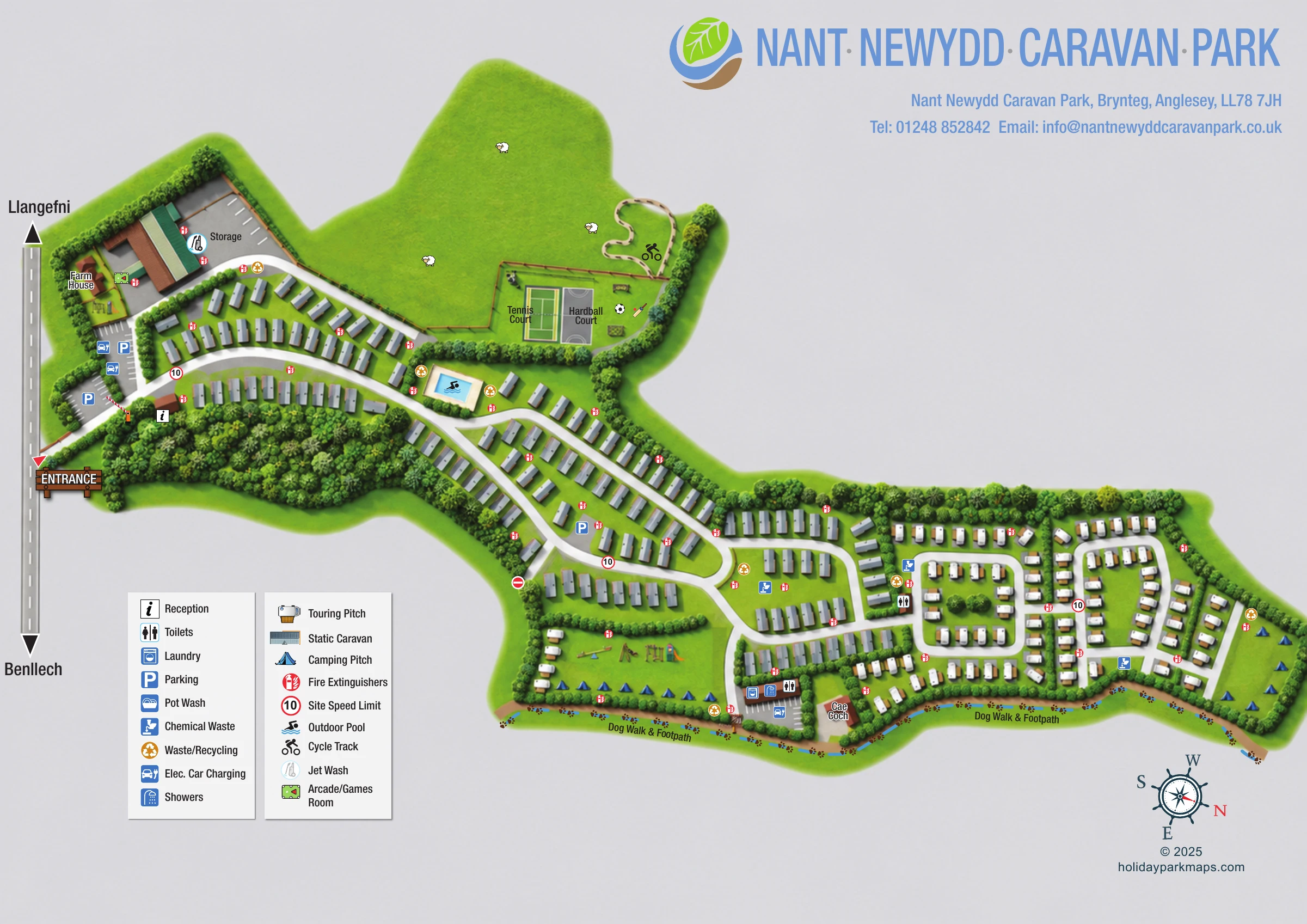
This illustrated map of Nant Newydd Caravan Park at Brynteg, Anglesey, brings a long, tree-lined holiday park into a single landscape-format view. Static caravans follow sweeping internal roads from the entrance, while touring pitches form a more compact group of loops towards the opposite end. Blue tent symbols distinguish the camping areas, and a labelled dog walk and footpath traces the lower boundary.
The map gives particular attention to the park's recreation spaces. An outdoor pool sits beside the main caravan route, with tennis and hardball courts, a grass sports area and a winding cycle track grouped above it. Illustrated playground equipment adds useful landmarks near the farmhouse and lower camping field.
Bright green grounds, layered tree canopies and shaded caravan roofs give the plan a welcoming rural character without obscuring the routes. A large blue title and leaf logo balance the irregular site shape, while the two-panel key explains accommodation, visitor facilities and safety symbols. It is a useful sample for mixed caravan parks needing one map to connect arrival, accommodation, recreation and everyday services.
The plan begins at the clearly marked entrance on the left, beside an external road with arrows towards Llangefni and Benllech. Parking bays, electric car charging and a small reception building establish the arrival area. Above them, the labelled Farm House and storage yard form a separate cluster, with games-room and jet-wash symbols nearby.
White internal roads curve through rows of grey-roofed static caravans, then branch into further accommodation groups along the park's elongated middle section. A densely illustrated wooded belt borders the entrance-side rows, while hedges and smaller tree groups separate later sections. The outdoor pool provides a strong visual landmark beside the main route. Beyond it, a fenced recreation area contains labelled tennis and hardball courts, grass sports symbols and a compact, winding cycle track.
At the right-hand end, touring caravans are arranged on grey pads around closely connected road loops. Camping is represented by blue tents in the far-right grass area and along the lower field, where illustrated play equipment occupies the open centre. Toilets, showers and laundry are marked at the lower amenity building, with another toilet point beside the touring section. Chemical waste, recycling and fire-extinguisher symbols recur across the plan. The separate building labelled Cae Coch sits near the lower facilities.
A tan Dog Walk & Footpath follows the lower perimeter, reinforced by paw prints and blue route marks. The page finishes with a two-panel legend at lower left and a rotated compass rose at lower right. The artwork is a single overall park map; the enlarged views show overlapping details of the same composition.
 Enlarge this map ↗
KEEP EXPLORING
Chosen for shared landscapes, accommodation or facilities.
 Explore the map ↗
United Kingdom
Woodland-framed Barnsoul map with mixed accommodation, shared facilities and paw-marked walking routes.
 Explore the map ↗
United Kingdom
A colour-zoned coastal park map with touring areas, woodland trails, ponds and a leisure club.
 Explore the map ↗
United Kingdom
A woodland estate park map combining caravan loops, touring pitches, riverside paths and Bruce’s Cave landmarks.
Features may come from the sample artwork, its key or published park information. Approximate numbers describe the drawing and may cover only part of a park. They are intended to help you compare map examples. Current facilities and booking information should be checked with the park.
LET’S MAP YOUR PARK
For a map quotation, find your park and draw a rough boundary around it. The area you select helps us work out the design time and price.
Draw your park for a quote ↗Or talk to our map designers
01751 473136