
Fields, hedges, trees and boundary divisions
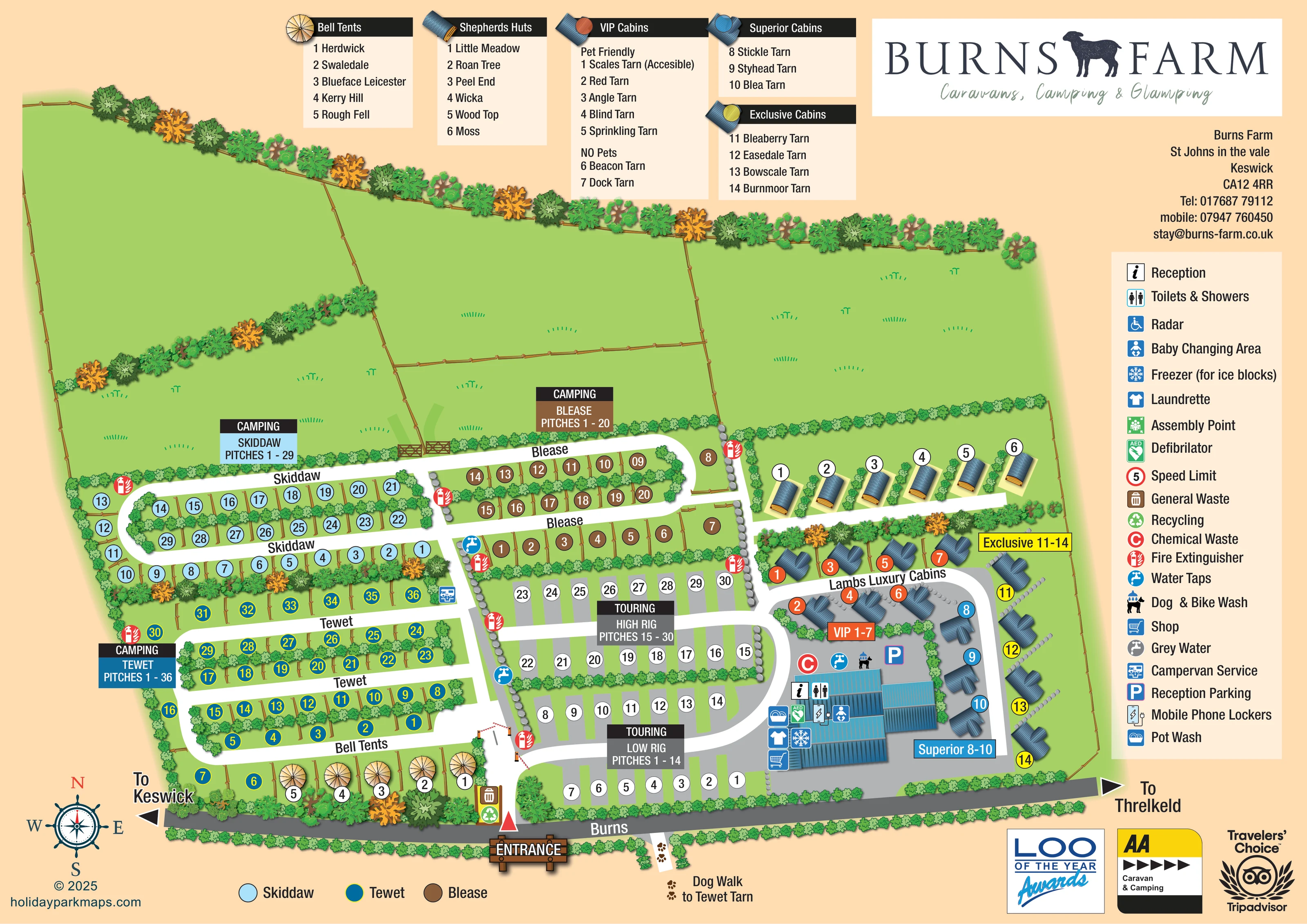
Large open green fields occupy the upper half. Timber fences, gates, mixed tree belts, low hedges and stone-like boundary markers divide the fields and accommodation areas.
ILLUSTRATED PARK MAP · P050
Burns Farm, St Johns in the vale, Keswick · United Kingdom
 Enlarge the map ↗
A SENSE OF THE PLACE
Burns Farm is a family-run caravan, camping and glamping site in St John's in the Vale near Keswick. The working-farm setting lies among Lake District hills, with Derwentwater and the surrounding fells offering places to explore.
Fully serviced hardstandings cater for touring vehicles, while separate grass fields provide tent camping. Glamping and cabin options add alternatives, and modern wet-room-style washrooms support stays across the site.
LOOK CLOSER
Large open green fields occupy the upper half. Timber fences, gates, mixed tree belts, low hedges and stone-like boundary markers divide the fields and accommodation areas.
Reception is marked on the large blue-roofed amenities building towards the lower right, with a parking symbol on the adjacent forecourt.
Toilets and showers and a separate baby-changing symbol are placed on the main amenities building.
A shopping-trolley symbol identifies the shop at the main amenities building.
Shirt and snowflake symbols locate the laundrette and freezer for ice blocks at the amenities building.
A washing-up symbol is mapped on the main amenities building.
A phone-and-plug symbol marks mobile phone lockers within the main facilities cluster.
The combined wash symbol sits on the forecourt beside the water tap and chemical-waste point.
Reception is marked on the large blue-roofed amenities building towards the lower right, with a parking symbol on the adjacent forecourt.
Toilets and showers and a separate baby-changing symbol are placed on the main amenities building.
The legend includes a wheelchair symbol labelled Radar; a separate location for this symbol is not evident on the plan.
A shopping-trolley symbol identifies the shop at the main amenities building.
Shirt and snowflake symbols locate the laundrette and freezer for ice blocks at the amenities building.
A washing-up symbol is mapped on the main amenities building.
A phone-and-plug symbol marks mobile phone lockers within the main facilities cluster.
The combined wash symbol sits on the forecourt beside the water tap and chemical-waste point.
Blue tap symbols are distributed along the central accommodation routes and beside the amenities building.
A campervan-service symbol is positioned beside the central route at the eastern end of the Tewet camping rows.
A red C symbol identifies chemical-waste disposal on the amenities forecourt.
A grey-water symbol appears in the legend, but a distinct matching location is not clear on the plan.
Paired waste and recycling symbols are placed beside the entrance route.
Red fire-extinguisher symbols recur around the camping and touring sections; a green AED symbol marks the defibrillator at the amenities building.
An assembly-point symbol is explained in the legend without a clearly identifiable placement on the plan.
The legend includes a red-ringed 5 speed-limit symbol; no separate position is apparent in the illustrated site.
The entrance is labelled on the lower boundary road, Burns, with arrows towards Keswick to the left and Threlkeld to the right. Barrier arms are illustrated just inside the entrance.
A short path with paw prints leaves the lower boundary east of the entrance and is labelled Dog Walk to Tewet Tarn. The onward route and tarn are not drawn.
Large open green fields occupy the upper half. Timber fences, gates, mixed tree belts, low hedges and stone-like boundary markers divide the fields and accommodation areas.
READING THE MAP
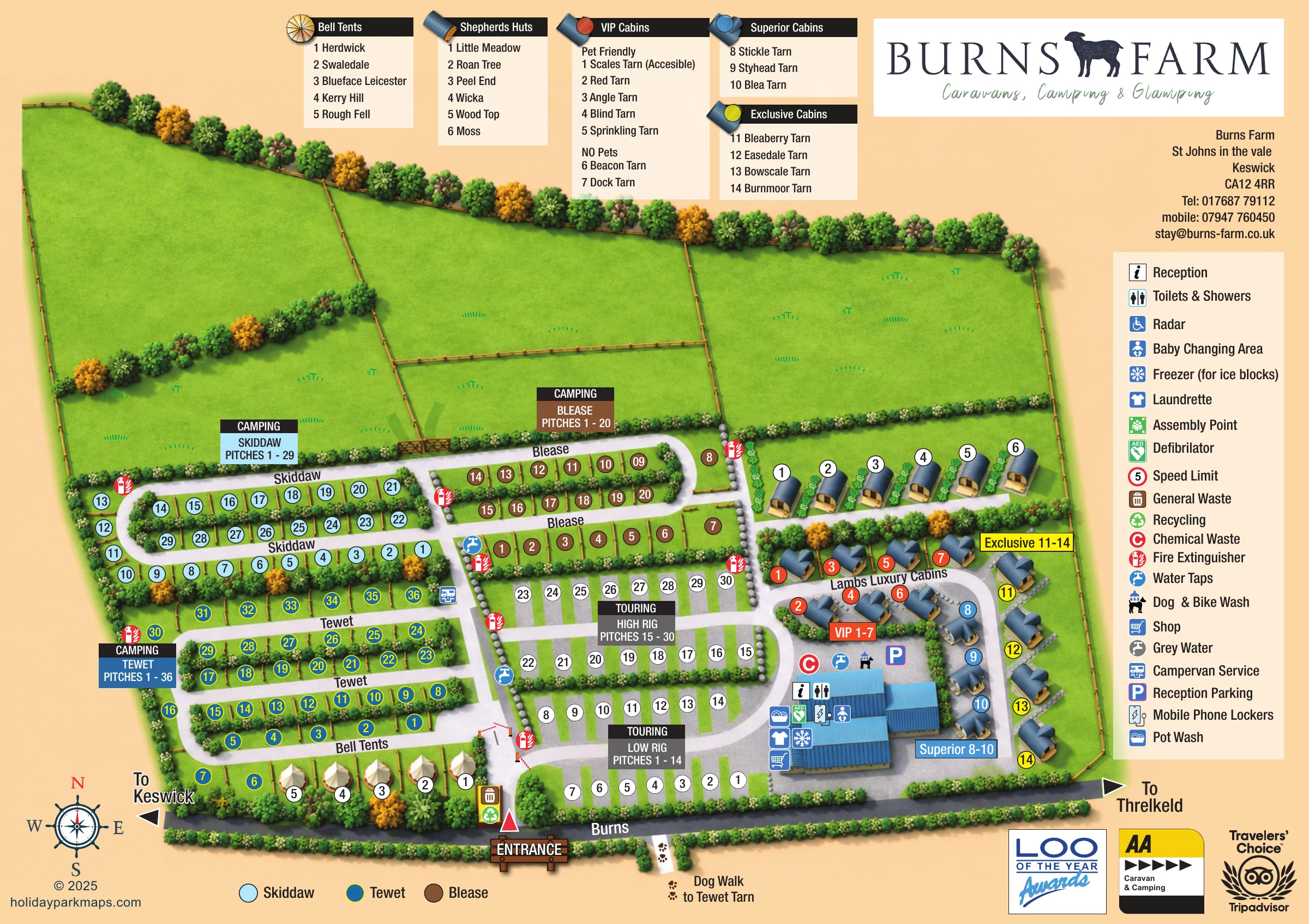
This illustrated map of Burns Farm brings together camping, touring and glamping in a rural Lake District setting near Keswick. Broad green fields, fenced boundaries and mixed tree belts occupy the upper part of the artwork, while the accommodation is organised into clearly named sections below. The result is a site plan that retains the farm’s open character without losing the detail visitors need to find their pitch or unit.
Skiddaw, Tewet and Blease camping areas use different coloured number markers, while the central Low Rig and High Rig touring sections are shown with grey hardstandings. Bell tents, shepherds’ huts and Lambs Luxury Cabins each have their own illustrated appearance and directory. On the right, a blue-roofed amenities building anchors the reception, washroom and service symbols.
The entrance, directions towards Keswick and Threlkeld, and a dog-walk reference to Tewet Tarn connect the internal plan to its surroundings. Warm peach margins, cream information panels and the distinctive Burns Farm sheep logo give this practical visitor map a recognisable farm identity.
The plan is arranged around an entrance from Burns, the road running along the lower edge. A white access lane leads past illustrated barriers into the accommodation, with waste and recycling symbols close to the entrance. External arrows point towards Keswick and Threlkeld, and a paw-print path marks the departure for the dog walk to Tewet Tarn.
To the left, Skiddaw and Tewet camping pitches sit in long rows around looping white lanes. Blease occupies the upper-middle camping block. Light blue, deep teal and brown number discs distinguish these three sections, reinforced by matching area labels and a small colour key beneath the plan. Hedges and timber dividers give the pitch rows structure, while larger fields beyond them are enclosed by fences, gates and tree belts.
Low Rig and High Rig touring pitches form a regular central block of grey hardstandings. Five illustrated bell tents sit along the lower-left boundary, and a separate row of six shepherds’ huts lies above the cabin area on the right. Lambs Luxury Cabins follow a curved lane, with orange, blue and yellow markers identifying the VIP, Superior and Exclusive groups. Their names appear in directories across the top of the page.
The blue-roofed amenities complex carries symbols for reception, toilets and showers, baby changing, pot wash, laundry, an ice-block freezer, shop, mobile phone lockers and a defibrillator. Reception parking, water, chemical waste and the dog and bike wash are shown on the surrounding forecourt. Further taps, fire extinguishers and a campervan-service point appear among the accommodation routes. A tall right-hand legend explains the pictograms. The artwork is a single landscape composition, with no separate inset or walking-map variant.
 Enlarge this map ↗
KEEP EXPLORING
Chosen for shared landscapes, accommodation or facilities.
 Explore the map ↗
United Kingdom
Illustrated farm campsite map with touring pitches, pods, camping fields and a riverside dog-walk route.
 Explore the map ↗
United Kingdom
Woodland park map with mixed pitches, bell tents, lodges and a fishing lake.
 Explore the map ↗
United Kingdom
Colour-coded accommodation, lakeside facilities and woodland routes at Burton Constable Holiday Park & Arboretum.
Features may come from the sample artwork, its key or published park information. Approximate numbers describe the drawing and may cover only part of a park. They are intended to help you compare map examples. Current facilities and booking information should be checked with the park.
LET’S MAP YOUR PARK
For a map quotation, find your park and draw a rough boundary around it. The area you select helps us work out the design time and price.
Draw your park for a quote ↗Or talk to our map designers
01751 473136