
Dog Walking Fields
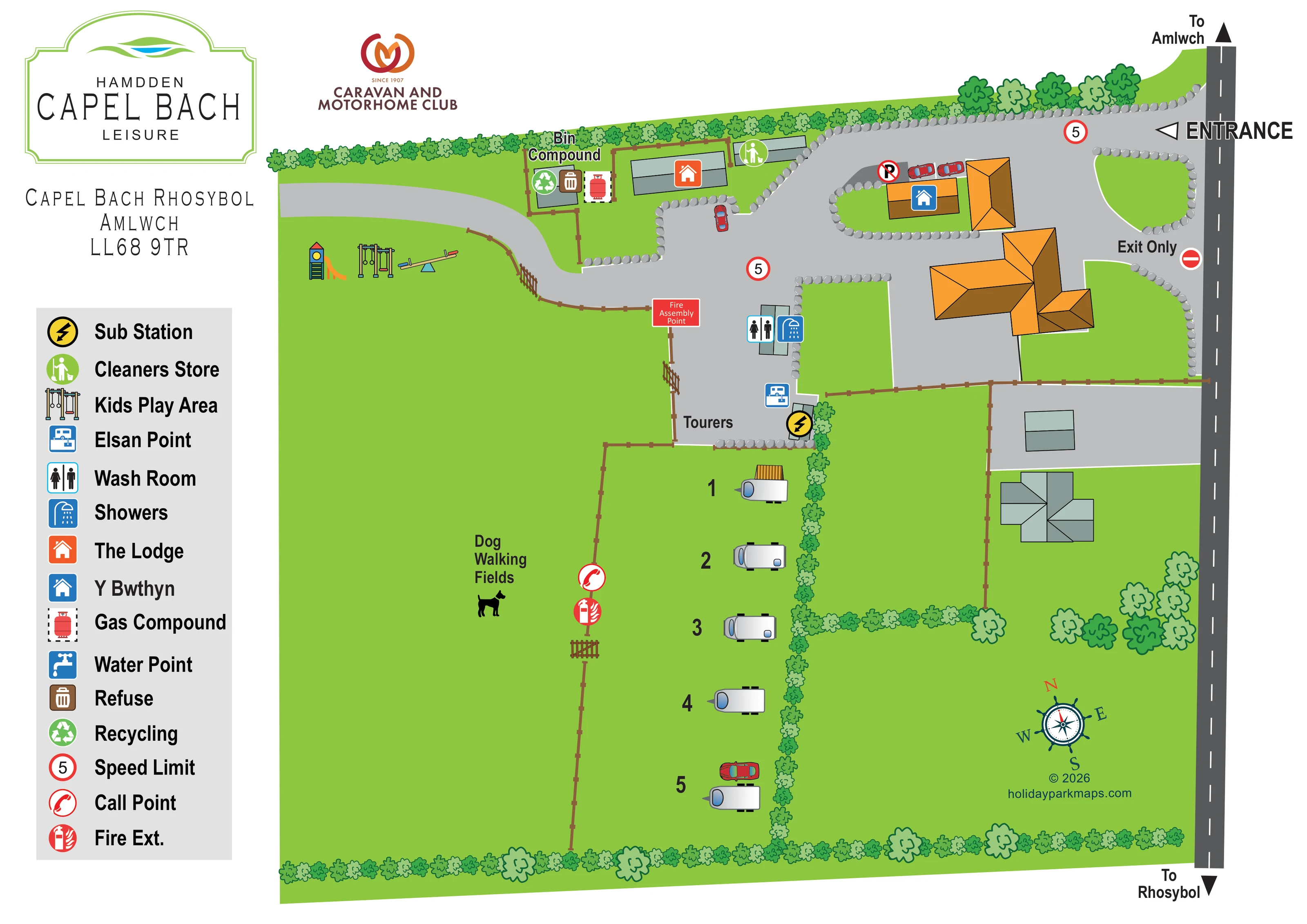
A large open field area to the left of the touring row, labelled with a dog silhouette and separated from the pitches by fencing and a gate.
ILLUSTRATED PARK MAP · P066
Capel Bach, Rhosybol, Amlwch · United Kingdom
 Enlarge the map ↗
A SENSE OF THE PLACE
Capel Bach Leisure is based at Capel Bach, Rhosybol, Amlwch. The listing describes countryside views towards Llyn Alaw and additional fields available for dog walks. The club lists a five-pitch certificated location for members.
The club description lists serviced pitches, electric hook-ups, Wi-Fi, showers and toilets.
LOOK CLOSER
A large open field area to the left of the touring row, labelled with a dog silhouette and separated from the pitches by fencing and a gate.
Continuous illustrated hedges define the outer boundaries and internal divisions, with larger trees around the roadside grounds.
A slide, swings and seesaw are drawn on grass beside the western branch of the internal drive.
Paired wash-room and shower symbols mark a small building beside the approach to the touring pitches.
A chemical-toilet disposal symbol is positioned at the lower end of the paved touring approach.
A fenced compound near the upper boundary carries refuse and recycling symbols.
A red cylinder symbol within a dashed outline marks the gas compound beside the bin compound.
A yellow electrical symbol marks a small structure beside the touring approach and hedge.
A large open field area to the left of the touring row, labelled with a dog silhouette and separated from the pitches by fencing and a gate.
Continuous illustrated hedges define the outer boundaries and internal divisions, with larger trees around the roadside grounds.
A slide, swings and seesaw are drawn on grass beside the western branch of the internal drive.
Paired wash-room and shower symbols mark a small building beside the approach to the touring pitches.
A chemical-toilet disposal symbol is positioned at the lower end of the paved touring approach.
A fenced compound near the upper boundary carries refuse and recycling symbols.
A red cylinder symbol within a dashed outline marks the gas compound beside the bin compound.
A yellow electrical symbol marks a small structure beside the touring approach and hedge.
A green cleaning symbol identifies a small rectangular building along the upper drive.
An orange house symbol identifies a long, grey-green roofed building near the upper boundary. Its precise visitor or accommodation function is not stated.
A blue house symbol identifies an orange-roofed building on an island within the arrival drive. The map does not specify its letting use.
A red labelled box marks the assembly point at the fence beside the touring approach.
Red call-point and extinguisher symbols are grouped beside the fence between the touring row and dog-walking fields.
A blue tap symbol is included in the legend; a corresponding position is not clearly shown on the plan.
The roadside arrival is labelled ENTRANCE, with a separate Exit Only opening below it and a no-entry symbol at that opening.
The public road runs down the right edge, with arrows towards Amlwch at the top and Rhosybol at the bottom.
Broad grey drives circulate around the arrival buildings and branch towards the play area and touring pitches. Brown fences and illustrated gates distinguish field and yard boundaries.
Red-ringed signs displaying 5 appear on the internal drive, and a no-parking symbol appears beside Y Bwthyn.
READING THE MAP
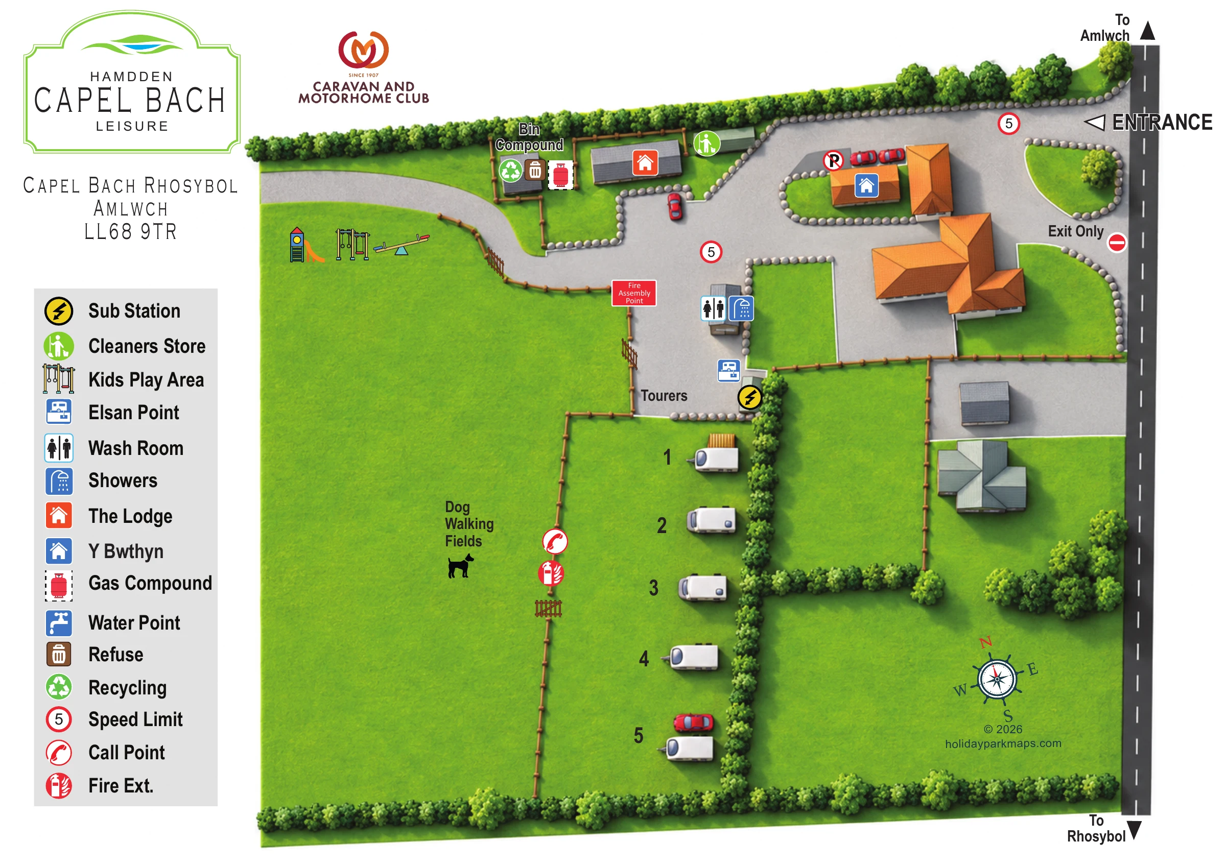
This illustrated map of Capel Bach Leisure presents a small countryside touring site at Rhosybol, near Amlwch on Anglesey. Rather than filling the page with accommodation blocks, the design gives generous space to the open fields, hedged boundaries and compact arrival area that define the site. A short row of touring pitches runs down the centre of the plan, with dog-walking fields clearly identified alongside it.
The entrance and separate exit connect directly to the road shown on the right, where arrows point towards Amlwch and Rhosybol. Within the grounds, pale-grey drives lead past named buildings and practical visitor facilities, including wash rooms, showers and an Elsan point. A small illustrated play area adds a recognisable landmark beside the western drive.
The page combines bilingual park branding, the Caravan and Motorhome Club logo and a large vertical symbol key. Bright green fields, orange roofs and colour-coded amenity icons make this a useful sample for small touring parks that need to explain arrival, pitch locations and everyday facilities without losing the character of their rural setting.
The single landscape-format plan is arranged around a roadside building cluster and a narrow touring area extending below it. The public road forms a strong dark-grey line down the right-hand side, with directional arrows to Amlwch and Rhosybol. An oversized entrance label marks the upper access, while a separate opening below is labelled Exit Only. Inside, a broad grey drive curves around orange-roofed buildings and grass islands edged with individual illustrated stones.
The Lodge is identified by an orange house icon near the upper boundary, and Y Bwthyn by a blue house icon within the arrival cluster. Nearby are the cleaners store, a fenced bin compound with refuse and recycling symbols, and the gas compound. These named landmarks give visitors reference points without requiring every building to carry a long text label.
The touring pitches appear as a short numbered row of white caravan drawings on grass. A continuous hedge runs along their right side, while a brown fence and gate separate them from the large area labelled Dog Walking Fields on the left. At the head of the row, symbols identify the wash room, showers, Elsan point and substation. The fire assembly point is labelled beside the approach, with a call point and extinguisher marked farther along the field boundary.
A slide, swings and seesaw illustrate the play area beside the western drive. Across the page, repeated hedge shapes and larger tree crowns distinguish planted boundaries from open ground. The left-hand column contains the park identity, address and large amenity legend; a compass rose sits in the lower-right grass area. The water-point symbol appears in the key, rather than at a clearly identifiable map location.
 Enlarge this map ↗
KEEP EXPLORING
Chosen for shared landscapes, accommodation or facilities.
 Explore the map ↗
United Kingdom
Woodland-framed Barnsoul map with mixed accommodation, shared facilities and paw-marked walking routes.
 Explore the map ↗
United Kingdom
Illustrated touring and camping map with hedge-divided fields, age-labelled play areas and a detailed service key.
 Explore the map ↗
United Kingdom
A wooded, streamside park map with a linked farm, café, touring and cottage area.
Features may come from the sample artwork, its key or published park information. Approximate numbers describe the drawing and may cover only part of a park. They are intended to help you compare map examples. Current facilities and booking information should be checked with the park.
LET’S MAP YOUR PARK
For a map quotation, find your park and draw a rough boundary around it. The area you select helps us work out the design time and price.
Draw your park for a quote ↗Or talk to our map designers
01751 473136