
Pond
A pale-blue, irregularly rounded water feature sits in the open western green space, edged by a narrow pale outline.
ILLUSTRATED PARK MAP · P440
Castle View & The Glade, Sunnybank, Capernwray, United Kingdom · United Kingdom
 Enlarge the map ↗
A SENSE OF THE PLACE
Castle View Holiday Park is part of McCarthy Parks at Capernwray near Carnforth. It forms part of the family's holiday home offering in the countryside at the north-eastern end of Morecambe Bay.
The wider location gives holiday homeowners access to North Lancashire and excursions towards the Lake District and Yorkshire Dales. The map provides a site-specific view of the plots and access routes at Castle View.
LOOK CLOSER
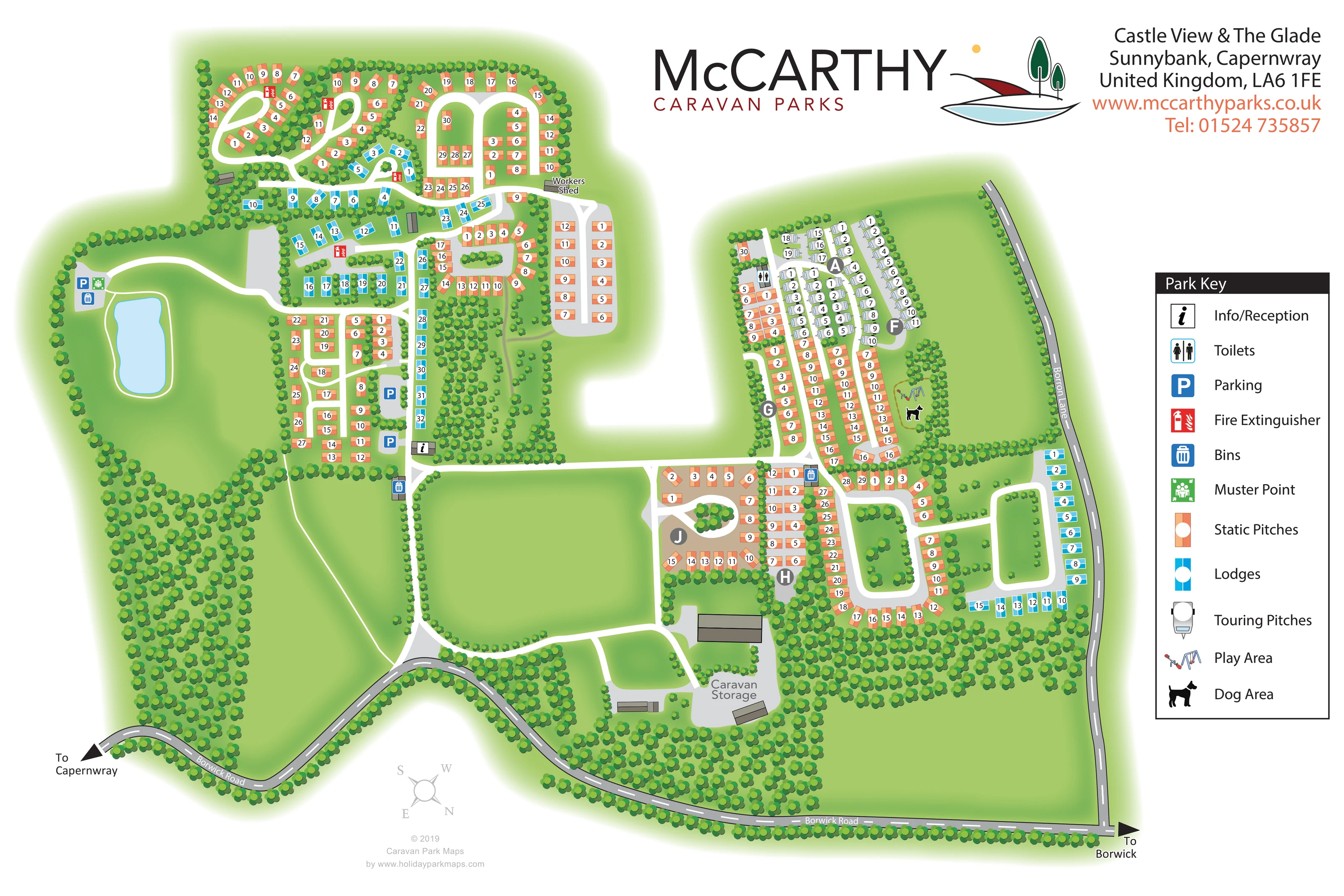
A pale-blue, irregularly rounded water feature sits in the open western green space, edged by a narrow pale outline.
Dense tree symbols frame the boundary, fill the southern margins and divide accommodation into smaller landscaped groups.
Large unnumbered green areas surround the pond, occupy the central southern part of the plan and separate eastern accommodation from Borron Lane.
An information/reception symbol marks a small building beside the main internal route at the southern end of the western accommodation groups.
A toilet symbol appears beside the northern eastern accommodation area, close to the touring pitches.
Blue parking symbols identify bays within the western accommodation area and a separate parking point near the pond.
Bin symbols are distributed at selected route junctions and beside the pond-side parking area.
Red fire-extinguisher symbols mark several locations among the western pitch groups.
An information/reception symbol marks a small building beside the main internal route at the southern end of the western accommodation groups.
A toilet symbol appears beside the northern eastern accommodation area, close to the touring pitches.
Blue parking symbols identify bays within the western accommodation area and a separate parking point near the pond.
Bin symbols are distributed at selected route junctions and beside the pond-side parking area.
Red fire-extinguisher symbols mark several locations among the western pitch groups.
A green muster-point symbol is positioned beside the parking and bin symbols near the pond.
An illustrated swing and seesaw mark a small recreation area immediately east of the long eastern accommodation rows.
A black dog silhouette identifies a dog area in the same tree-edged green space as the play-area illustration.
A labelled grey storage compound with simple building footprints lies near the southern entrance routes.
A small rectangular building at the upper-right edge of the western accommodation area is labelled Workers Shed.
A pale-blue, irregularly rounded water feature sits in the open western green space, edged by a narrow pale outline.
Dense tree symbols frame the boundary, fill the southern margins and divide accommodation into smaller landscaped groups.
Large unnumbered green areas surround the pond, occupy the central southern part of the plan and separate eastern accommodation from Borron Lane.
Borwick Road follows the southern boundary, with arrows towards Capernwray and Borwick; Borron Lane runs along the eastern edge.
Pale internal routes connect the southern approaches with accommodation loops, parking, storage and the pond-side area; a thinner path crosses western open ground.
READING THE MAP
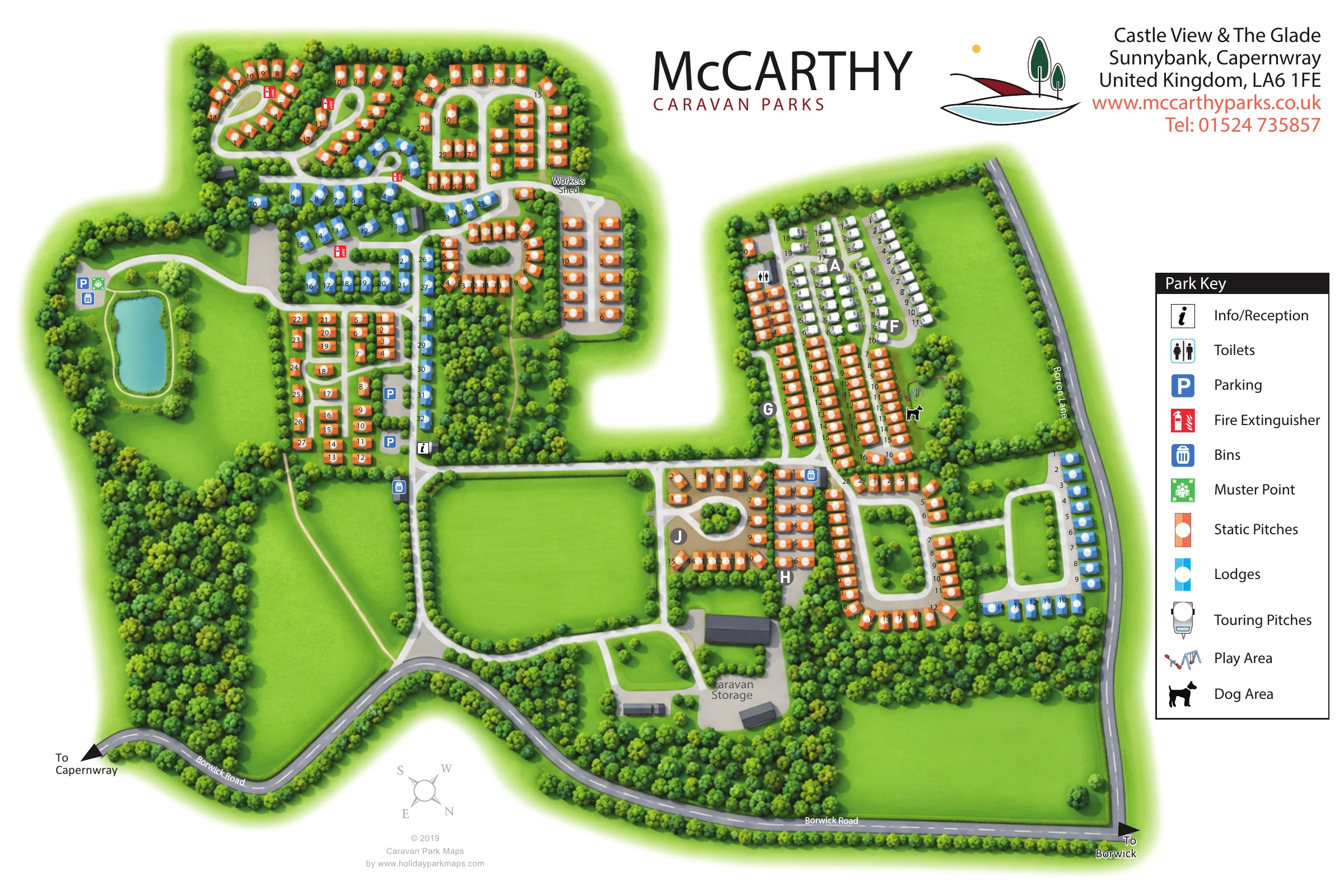
This illustrated map of Castle View & The Glade at Capernwray presents a sizeable countryside holiday park as a series of manageable, tree-framed neighbourhoods. Rather than treating the site as one continuous grid, the artwork separates its accommodation into curved courts, short rows and longer avenues, linked by a clear network of pale internal lanes. Orange static pitches, blue lodges and grey touring caravans give visitors an immediate way to recognise the different accommodation areas.
The setting is an important part of the composition. Dense woodland borders, planted divisions, broad green spaces and a small western pond give the plan a distinctly leafy character. Borwick Road curves around the southern edge, while Borron Lane defines the eastern side; arrows towards Capernwray and Borwick place the site within its local road network.
Practical details include reception, parking, toilets, bins, fire-extinguisher points and a muster point, alongside a play area, dog area and caravan storage compound. A prominent McCarthy Caravan Parks masthead and a separate, generously sized key make this a useful example of branded visitor mapping for a mixed-accommodation park.
The single landscape artwork shows two main accommodation concentrations connected by an internal lane across the centre of the site. In the western half, compact static-pitch loops occupy the upper edge, with blue lodge groups woven between tree belts below them. Further static courts and lodge rows extend south towards the information/reception marker and parking areas. A broad green space opens to the west, containing a pale-blue pond and a nearby cluster of parking, bin and muster-point symbols.
The eastern half has a different rhythm. Grey touring-caravan symbols occupy its northern rows, with orange static pitches continuing south in long, closely arranged avenues. Large grey circles carry section letters, adding another level of identification alongside the individual pitch numbers. A small tree-edged recreation space contains the play-equipment illustration and dog-area symbol. Lower down, more static pitches wrap around planted courts, while blue lodges form an L-shaped group beside Borron Lane and the southern woodland margin.
Borwick Road is drawn as a grey, dashed-centre-line road along the bottom of the plan, with directional arrows towards Capernwray and Borwick. Pale access lanes branch into the park, passing the labelled caravan storage compound and connecting with the accommodation network. A workers shed is labelled at the eastern edge of the western groups, and toilets are marked near the touring area.
The right-hand Park Key explains the accommodation colours and service symbols in large, separated entries. Above it, the McCarthy branding, landscape logo and location details occupy open white space. A small rotated compass completes the orientation information without competing with the plan. The enlarged detail view repeats part of this same artwork, making the eastern layout and key easier to read.
 Enlarge this map ↗
KEEP EXPLORING
Chosen for shared landscapes, accommodation or facilities.
 Explore the map ↗
United Kingdom
Woodland-framed Barnsoul map with mixed accommodation, shared facilities and paw-marked walking routes.
 Explore the map ↗
United Kingdom
A colour-zoned coastal park map with touring areas, woodland trails, ponds and a leisure club.
 Explore the map ↗
United Kingdom
Woodland holiday-park map with named accommodation areas, touring loops and illustrated recreation facilities.
Features may come from the sample artwork, its key or published park information. Approximate numbers describe the drawing and may cover only part of a park. They are intended to help you compare map examples. Current facilities and booking information should be checked with the park.
TAKE A CLOSER LOOK
View the illustrated map in detail or choose a file to download. These are sample maps; contact the park for current visitor information.


LET’S MAP YOUR PARK
For a map quotation, find your park and draw a rough boundary around it. The area you select helps us work out the design time and price.
Draw your park for a quote ↗Or talk to our map designers
01751 473136