
Landscaped pond
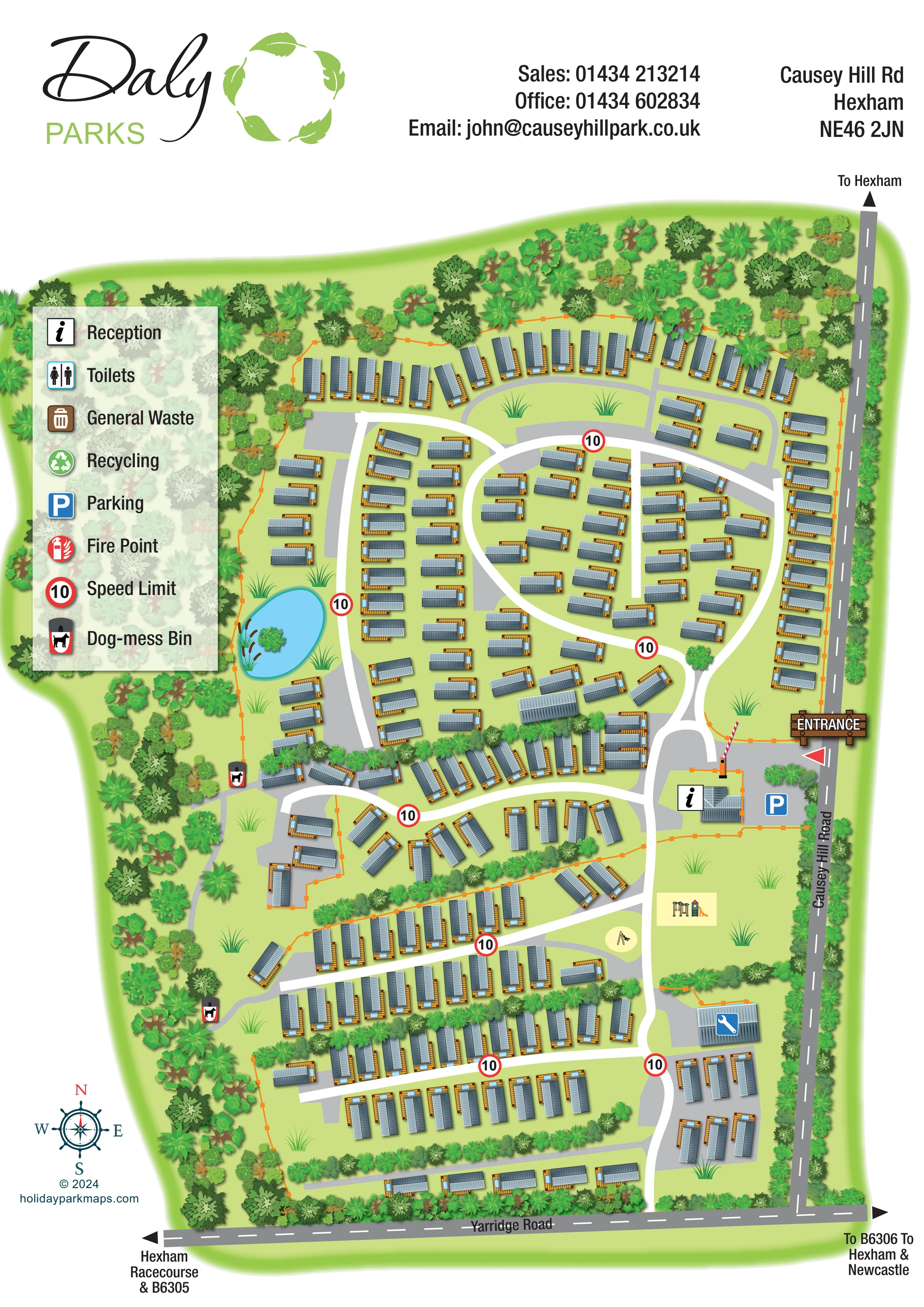
A small blue pond with reeds and a planted feature sits west of the northern accommodation groups.
ILLUSTRATED PARK MAP · P073
Causey Hill Rd, Hexham · United Kingdom
 Enlarge the map ↗
A SENSE OF THE PLACE
Causey Hill is an owners-only holiday park near Hexham in Northumberland. Its elevated position offers views across the Tyne Valley, with the town and Hadrian's Wall country providing places to explore.
Static holiday homes form the focus of the park. The setting suits repeated countryside breaks, and the map helps owners and visitors understand the arrangement of homes and internal roads. Accommodation is for holiday use rather than permanent residence.
LOOK CLOSER
A small blue pond with reeds and a planted feature sits west of the northern accommodation groups.
Dense illustrated trees frame the northern and western boundaries, while hedges and shrub belts divide several accommodation rows.
An information symbol identifies the reception building immediately inside the eastern entrance.
A blue parking symbol marks the grey forecourt beside reception and Causey Hill Road.
A timber-style entrance sign, red directional marker and raised striped barrier emphasise the arrival point from Causey Hill Road.
A swing-and-slide illustration occupies a pale rectangular area on the open lawn south of reception, with a separate swing illustration nearby.
A larger roofed building beside the southern access spine carries a blue spanner symbol, suggesting a maintenance or workshop function; it is not named in the legend.
Repeated dog-mess bin symbols appear beside the western perimeter route.
An information symbol identifies the reception building immediately inside the eastern entrance.
A blue parking symbol marks the grey forecourt beside reception and Causey Hill Road.
A timber-style entrance sign, red directional marker and raised striped barrier emphasise the arrival point from Causey Hill Road.
A swing-and-slide illustration occupies a pale rectangular area on the open lawn south of reception, with a separate swing illustration nearby.
A larger roofed building beside the southern access spine carries a blue spanner symbol, suggesting a maintenance or workshop function; it is not named in the legend.
Repeated dog-mess bin symbols appear beside the western perimeter route.
Red-ringed signs displaying 10 recur at internal road junctions and along the circulation routes.
A small blue pond with reeds and a planted feature sits west of the northern accommodation groups.
Dense illustrated trees frame the northern and western boundaries, while hedges and shrub belts divide several accommodation rows.
Named public roads border the east and south of the plan. Arrows indicate Hexham, Hexham Racecourse and the B6305, and the B6306 towards Hexham and Newcastle.
Included in the symbol key, without a clearly identifiable matching location on the main plan.
Separate general-waste and recycling symbols are explained in the legend; their positions are not clearly marked on the plan.
A fire-point symbol appears in the legend, without a clearly identifiable corresponding marker within the park.
READING THE MAP
This illustrated map of Causey Hill Holiday Park brings a sizeable static holiday-home layout into a single portrait view. Set near Hexham in Northumberland, the park is shown within a leafy enclosure, with Causey Hill Road along its eastern edge and Yarridge Road across the bottom. The entrance, reception and parking form an immediate point of reference before the internal routes lead into the accommodation areas.
The artwork combines a curved northern layout with more regular rows further south. Grey-blue roofs and orange decking give the homes a consistent appearance, while varied trees and planted dividers keep the different groups visually distinct. A small pond on the western side and a play lawn near reception add useful landmarks beyond the accommodation itself.
Daly Parks branding, a large symbol key, a compass and road-direction arrows complete the page. It is a useful example for an ownership-led holiday park needing to explain its overall arrangement without relying on dense plot numbering.
The plan places the main entrance on Causey Hill Road, approximately halfway down the right-hand edge. A timber-style entrance sign and striped barrier draw attention to the turn into the park. Reception is marked with an information icon beside a blue parking symbol, establishing a compact arrival area before the internal road divides towards the northern and southern accommodation sections.
In the north, homes follow the rounded wooded boundary and sit in staggered groups within a broad looping route. Further west, a bright blue pond is illustrated with reeds and a planted feature. The southern half changes character: straighter cross-lanes serve repeated rows of homes, with shrub and tree belts separating several groups. An open lawn east of the main internal spine contains swing-and-slide equipment and a separate swing illustration. Further south, a larger building carries a blue spanner symbol.
The home illustrations use ribbed grey-blue roofs, orange decking surrounds and small blue entrance details. Their changing orientation helps explain how each group relates to its lane. Dense trees frame the park, while orange fence-like lines articulate boundaries within the plan. Red-ringed 10 signs recur along internal routes, and dog-mess bin symbols mark points beside the western route.
A translucent legend overlays the upper-left woodland and explains the principal facility symbols, including some entries whose locations are not marked on the main plan. Named public roads, outward destination arrows and a decorative compass provide wider orientation. The single-page composition is topped by Daly Parks branding, contact information and the Hexham address, with the designer credit placed in the lower-left margin.
KEEP EXPLORING
Chosen for shared landscapes, accommodation or facilities.
 Explore the map ↗
United Kingdom
Woodland-framed Barnsoul map with mixed accommodation, shared facilities and paw-marked walking routes.
 Explore the map ↗
United Kingdom
A colour-zoned coastal park map with touring areas, woodland trails, ponds and a leisure club.
 Explore the map ↗
United Kingdom
Illustrated lakeside park plan with numbered holiday units, leisure buildings and a looping Woodland Walk.
Features may come from the sample artwork, its key or published park information. Approximate numbers describe the drawing and may cover only part of a park. They are intended to help you compare map examples. Current facilities and booking information should be checked with the park.
LET’S MAP YOUR PARK
For a map quotation, find your park and draw a rough boundary around it. The area you select helps us work out the design time and price.
Draw your park for a quote ↗Or talk to our map designers
01751 473136