
Central lake
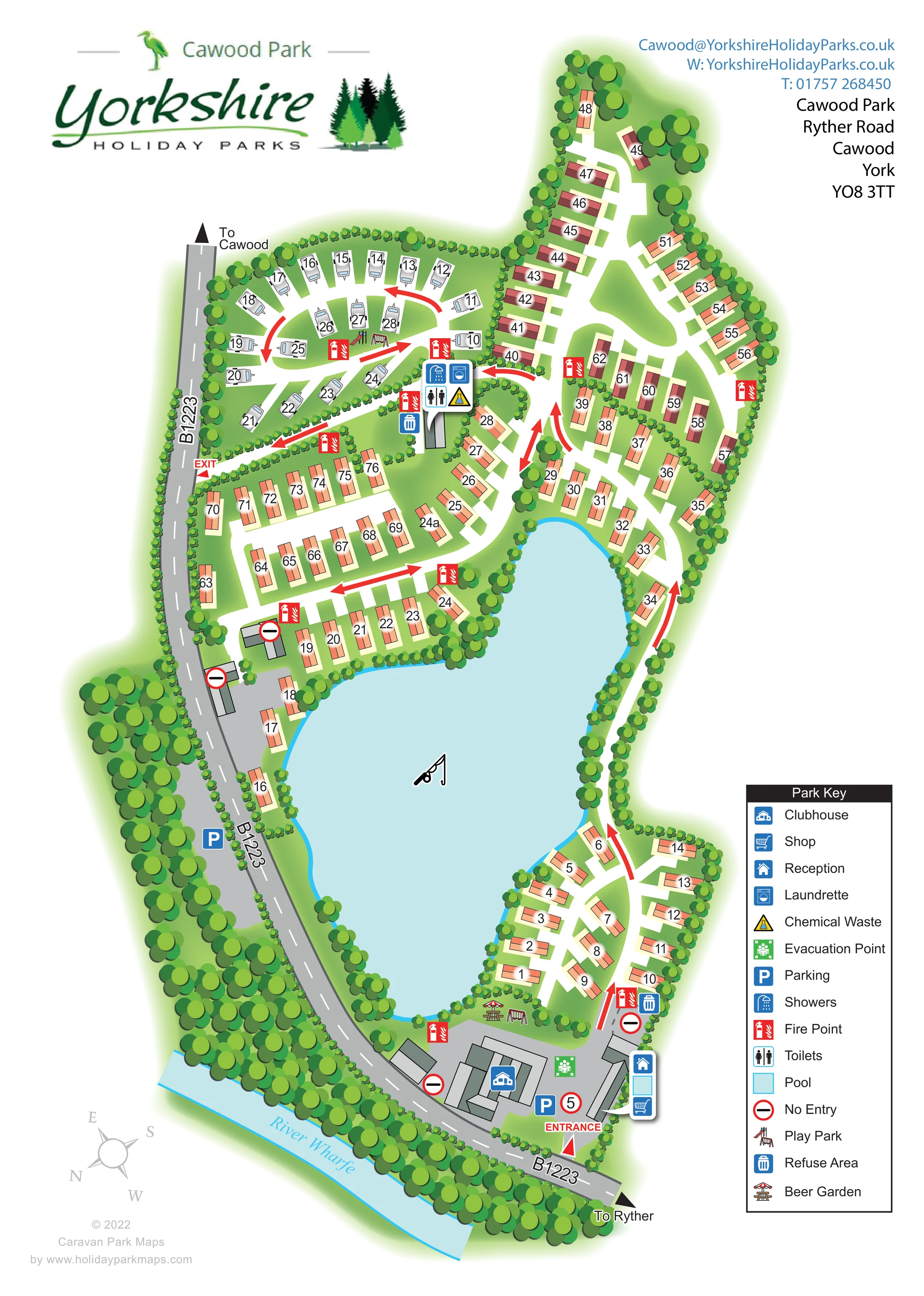
A large, irregular pale-blue lake dominates the middle and lower part of the plan, with tree-lined banks and accommodation around several sides.
ILLUSTRATED PARK MAP · P441
Cawood Park, Ryther Road, Cawood, York · United Kingdom
 Enlarge the map ↗
A SENSE OF THE PLACE
Cawood Park is a holiday park near Cawood and York, with a lake and landscaped grounds forming the setting for lodges and holiday homes. Properties are offered for ownership and holiday stays, alongside touring pitches.
The park's own information describes a bar, swimming pool and entertainment. Its position in North Yorkshire provides a base for exploring York and the surrounding countryside, while the map explains the layout within the grounds.
LOOK CLOSER
A large, irregular pale-blue lake dominates the middle and lower part of the plan, with tree-lined banks and accommodation around several sides.
A labelled blue strip runs diagonally along the southern edge, separated from the park by the road and a substantial belt of trees.
Dense stylised trees frame the site, line the lake and divide accommodation groups; smaller repeated planting symbols mark internal boundaries.
A rod-and-line illustration marks the central lake as a fishing-related feature; no fishing conditions are stated.
The clubhouse symbol identifies the substantial building complex near the southern entrance.
A reception icon is grouped beside the eastern entrance-side building with the pool and shop icons.
The shop is marked in the entrance-side facility cluster.
A pale-blue square in the entrance-side icon stack marks the pool; it is distinct from the large central lake.
A large, irregular pale-blue lake dominates the middle and lower part of the plan, with tree-lined banks and accommodation around several sides.
A rod-and-line illustration marks the central lake as a fishing-related feature; no fishing conditions are stated.
A labelled blue strip runs diagonally along the southern edge, separated from the park by the road and a substantial belt of trees.
Dense stylised trees frame the site, line the lake and divide accommodation groups; smaller repeated planting symbols mark internal boundaries.
The clubhouse symbol identifies the substantial building complex near the southern entrance.
A reception icon is grouped beside the eastern entrance-side building with the pool and shop icons.
The shop is marked in the entrance-side facility cluster.
A pale-blue square in the entrance-side icon stack marks the pool; it is distinct from the large central lake.
A washing-machine icon marks the laundrette at the service building beside the touring area.
Shower and toilet symbols are grouped at the touring-area service building.
A yellow warning-style chemical waste symbol appears in the touring service cluster.
Play-equipment illustrations appear within the touring loop and beside the southern lakeshore near the clubhouse.
A parasol-and-table illustration marks the beer garden between the clubhouse area and the lake.
Blue parking symbols appear beside the entrance facilities and along the western road edge.
Bin symbols identify refuse points near the touring services and the southern accommodation group.
Repeated red extinguisher symbols are distributed through the accommodation areas and around the entrance facilities.
A green assembly-style symbol marks an evacuation point in the entrance and clubhouse area.
The entrance is labelled at the southern facility hub; a separate exit is labelled farther north on the western boundary.
White internal roads branch and loop between accommodation groups. Red arrows show circulation directions, with no-entry symbols at selected access points and a circular 5 sign near the entrance.
The grey B1223 follows the western and southern edges, with arrows labelled towards Cawood and Ryther.
READING THE MAP
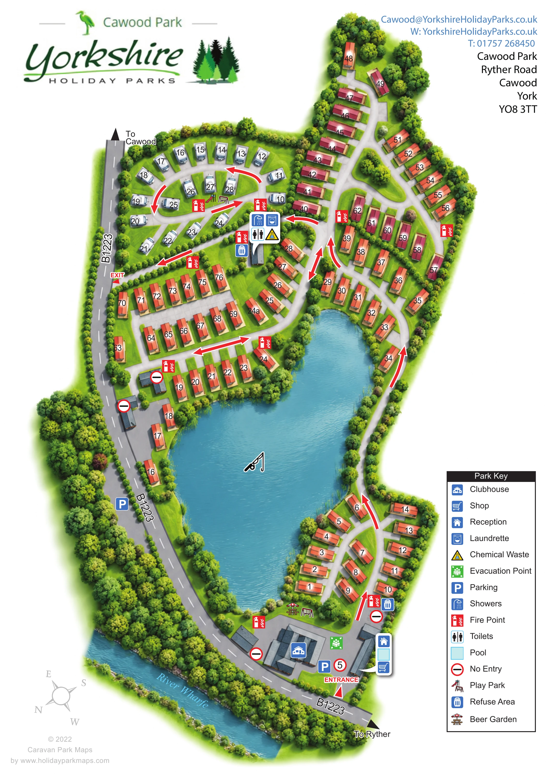
This illustrated map of Cawood Park places a large central lake at the heart of a tree-lined holiday park near Cawood and York. Fixed holiday accommodation follows the shoreline and extends into branching lanes to the north, while a separate touring area occupies a loop in the north-western corner. The B1223 curves along the western and southern boundaries, with the River Wharfe illustrated beyond the southern tree belt.
The portrait layout brings accommodation, arrival information and visitor facilities together on one page. Reception, the shop, pool and clubhouse form a clear southern arrival hub, while the touring service building is identified with shower, toilet, laundry and chemical waste symbols. Play areas and a beer garden add useful landmarks around the accommodation and lake.
Peach-coloured roofs, white roads, layered green trees and pale-blue water give the plan a recognisable visual structure. Strong red route arrows and a dedicated Park Key help visitors interpret the internal road network without losing the character of the landscaped setting.
The plan follows Cawood Park’s elongated shape, from the entrance beside the southern buildings to the narrow accommodation extension at the top of the page. A broad, irregular lake fills much of the centre, with a fishing-rod illustration placed over the water. Trees closely follow its banks, and fixed holiday units are arranged in short rows and curved clusters on both sides.
At the southern end, the clubhouse occupies a substantial grey building footprint beside parking and an evacuation point. A neighbouring building is identified by stacked reception, pool and shop symbols. The beer-garden illustration and a small play area sit between this facility hub and the lakeshore. The entrance label, red arrows and no-entry signs make this relatively compact arrival area distinct from the accommodation roads.
Farther north, white roads branch through peach-roofed units and a group of darker red-roofed units. Large black plot numbers sit on pale highlights. On the opposite side, the touring loop is immediately recognisable from its white caravan drawings. Its service building carries shower, toilet, laundrette and chemical waste symbols, with a refuse point nearby and play equipment within the loop. Fire-point icons recur across the plan.
The grey B1223 provides an external reference along the western and southern edges, with directions towards Cawood and Ryther. The River Wharfe is labelled beyond a dense southern tree belt. A rotated compass, prominent park branding, contact block and tall right-hand legend complete the page. The accompanying enlargement shows the same entrance area and Park Key in greater detail, rather than a separate map or additional accommodation.
 Enlarge this map ↗
KEEP EXPLORING
Chosen for shared landscapes, accommodation or facilities.
 Explore the map ↗
United Kingdom
Wooded estate map with named lodge areas, lakeside touring, a hall-side arrival hub and Offa's Dyke Path.
 Explore the map ↗
United Kingdom
Woodland park map with mixed pitches, bell tents, lodges and a fishing lake.
 Explore the map ↗
United Kingdom
Illustrated lakeside park plan with numbered holiday units, leisure buildings and a looping Woodland Walk.
Features may come from the sample artwork, its key or published park information. Approximate numbers describe the drawing and may cover only part of a park. They are intended to help you compare map examples. Current facilities and booking information should be checked with the park.
TAKE A CLOSER LOOK
View the illustrated map in detail or choose a file to download. These are sample maps; contact the park for current visitor information.


LET’S MAP YOUR PARK
For a map quotation, find your park and draw a rough boundary around it. The area you select helps us work out the design time and price.
Draw your park for a quote ↗Or talk to our map designers
01751 473136