
Named pitch fields and meadows
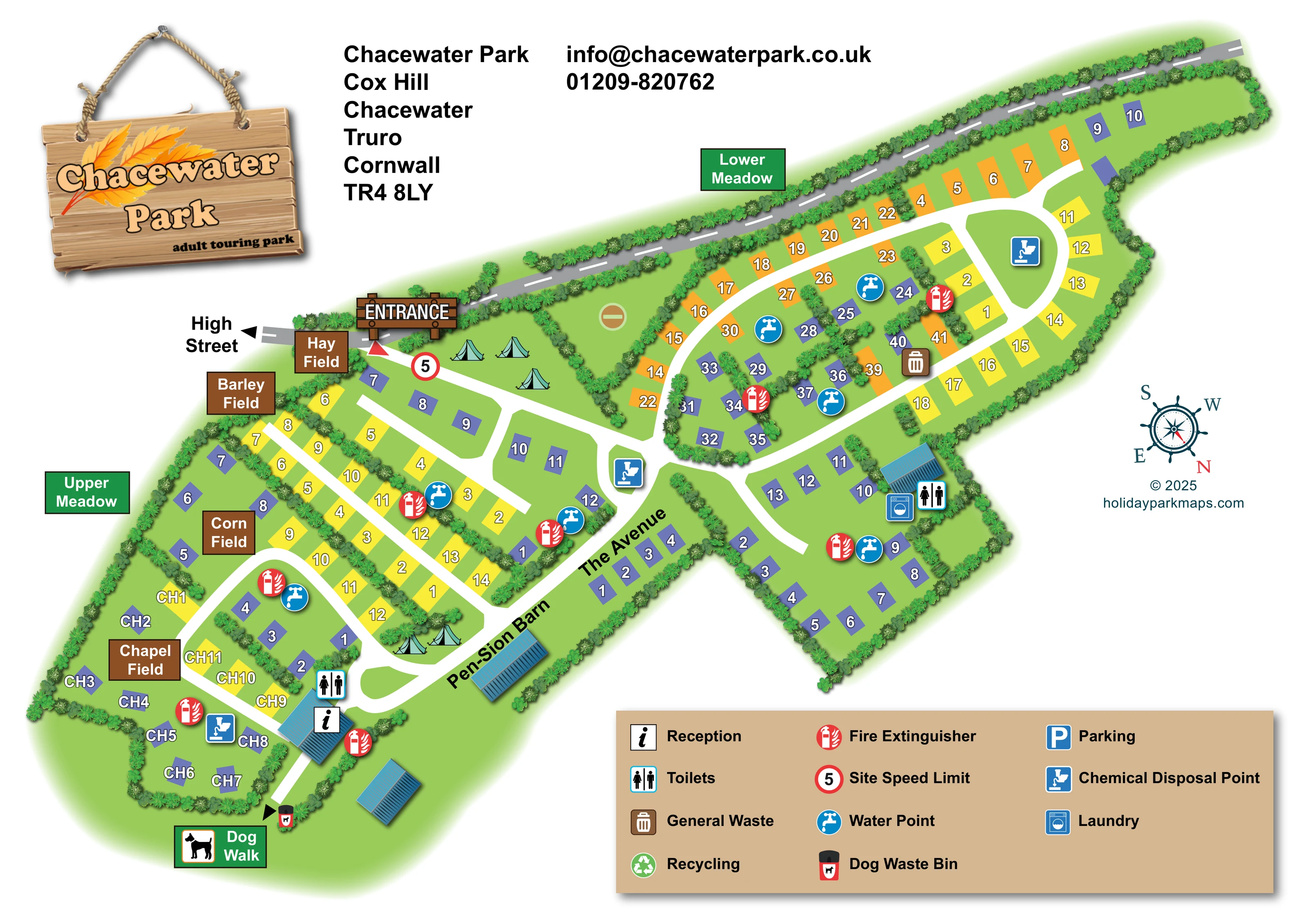
Hay Field, Barley Field, Corn Field and Chapel Field are labelled on brown panels; Upper Meadow and Lower Meadow use green panels.
ILLUSTRATED PARK MAP · P076
Chacewater Park, Cox Hill, Chacewater, Truro, Cornwall · United Kingdom
 Enlarge the map ↗
A SENSE OF THE PLACE
Chacewater Park is a touring base at Cox Hill in west Cornwall, close to the A30. Its location provides access to the county's north-coast beaches and the Mineral Tramways trail network.
All-weather hardstanding pitches have electricity, with fully serviced options adding water and drainage. Basic provisions and camping accessories are available on site, supporting visitors who plan to explore Cornwall from their touring accommodation.
LOOK CLOSER
Hay Field, Barley Field, Corn Field and Chapel Field are labelled on brown panels; Upper Meadow and Lower Meadow use green panels.
Dense illustrated shrubs enclose the park, line the roadside and divide pitch rows into smaller compartments across a light-green grass base.
An information symbol identifies reception at the blue-roofed building beside Chapel Field and the lower turning loop.
Toilet symbols mark buildings near reception and in the lower-right pitch area.
A washing-machine symbol accompanies the toilet building in the lower-right area.
Blue disposal symbols appear in Chapel Field, at the central junction and within the upper-right loop.
Blue tap symbols are distributed through the pitch fields, including the left-hand rows, upper-right blocks and lower-right area.
Repeated red extinguisher symbols provide conspicuous service landmarks across the plan.
An information symbol identifies reception at the blue-roofed building beside Chapel Field and the lower turning loop.
Toilet symbols mark buildings near reception and in the lower-right pitch area.
A washing-machine symbol accompanies the toilet building in the lower-right area.
Blue disposal symbols appear in Chapel Field, at the central junction and within the upper-right loop.
Blue tap symbols are distributed through the pitch fields, including the left-hand rows, upper-right blocks and lower-right area.
Repeated red extinguisher symbols provide conspicuous service landmarks across the plan.
A brown waste-bin symbol is positioned beside pitches in the upper-right section.
A red-and-black dog waste bin is shown beside the lower route towards the dog walk.
Parking appears in the key, but no corresponding position is clearly marked on the plan.
A green recycling symbol is included in the key without a clearly identifiable mapped location.
A timber entrance sign and red triangular marker identify the access from the grey road along the upper edge.
A left-pointing arrow beside the approach road directs visitors towards High Street.
Broad white routes form a branching network of straight pitch lanes, connecting junctions and rounded loops.
A named diagonal lane links the central junction with the lower reception area and passes a short row of pitches.
A green sign with a dog pictogram and a directional arrow identifies the dog walk beyond the lower end of the internal lane; a full walking circuit is not drawn.
A red-ringed marker displaying 5 is drawn just inside the entrance and explained in the key as the site speed limit.
Hay Field, Barley Field, Corn Field and Chapel Field are labelled on brown panels; Upper Meadow and Lower Meadow use green panels.
Dense illustrated shrubs enclose the park, line the roadside and divide pitch rows into smaller compartments across a light-green grass base.
A blue-roofed building beside The Avenue is labelled Pen-Sion Barn. Its function is not specified.
READING THE MAP
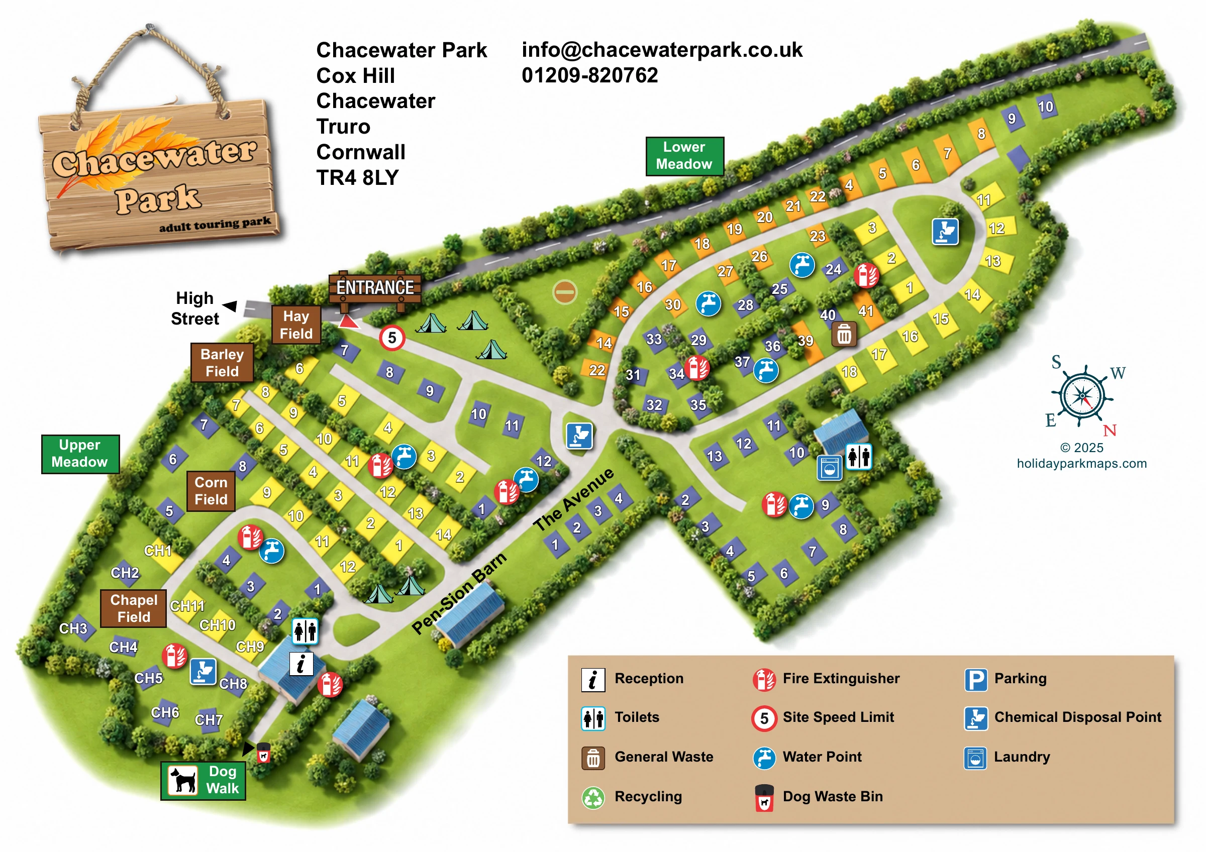
This illustrated map of Chacewater Park presents a touring site at Cox Hill, Chacewater, near Truro in Cornwall. Its long, irregular footprint is arranged diagonally across the page, with numbered pitches grouped into hedge-lined fields and linked by a clear network of white lanes. Hay Field, Barley Field, Corn Field and Chapel Field give visitors memorable area names, alongside Upper Meadow, Lower Meadow and The Avenue.
The map combines practical pitch-finding information with a distinctive rural identity. A rope-hung timber logo with autumn leaves occupies the upper left, while a matching entrance sign marks arrival from the roadside. Blue-roofed buildings, repeated water and fire-point symbols, and a large tan key help visitors locate everyday facilities without losing sight of the overall layout.
Reception is shown near the lower turning loop, with toilets, laundry and chemical disposal points identified elsewhere on the plan. A labelled dog-walk direction adds another useful destination. This sample is particularly relevant to touring parks that need to explain several adjoining pitch fields within one coherent visitor map.
The single landscape-format map follows Chacewater Park's elongated shape from Chapel Field at the lower left to the long upper-right pitch area. A grey road with dashed white markings runs along the upper boundary, and a High Street arrow provides an external reference. The main entrance is emphasised with a timber sign and red triangular marker, followed by a red-ringed speed-limit symbol.
Inside the park, broad white lanes branch into parallel rows, smaller hedge-enclosed groups and rounded loops. The left-hand fields are identified by brown name panels for Hay, Barley, Corn and Chapel, with Upper Meadow labelled in green. Lower Meadow is named beside the upper roadside boundary. The Avenue forms a diagonal connection towards reception and passes the blue-roofed Pen-Sion Barn. A smaller pitch area extends towards the lower right around another curved lane.
Accommodation is shown as numbered purple, yellow and orange rectangles. The colours make neighbouring groups visually distinct, although their meaning is not explained in the key. Small tent illustrations occupy grassy spaces near the entrance and lower central junction, rather than forming a separately numbered camping layout. Detailed shrub clusters trace boundaries and divide the rows, making the site's compartmental structure easy to see.
Facility symbols identify reception, two toilet locations, laundry, water points, chemical disposal points, fire extinguishers and general waste. At the lower edge, a dog-walk sign and arrow sit beside a dog waste bin. The large tan key also includes parking and recycling symbols. A nautical-style compass at the right explains the rotated orientation, while the timber logo, address and contact block balance the plan across the top of the page.
 Enlarge this map ↗
KEEP EXPLORING
Chosen for shared landscapes, accommodation or facilities.
 Explore the map ↗
United Kingdom
Ashby Park map with seven fishing lakes, colour-coded accommodation and illustrated wooded shorelines.
 Explore the map ↗
United Kingdom
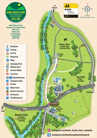
Riverside campsite map with named camping fields, touring-caravan rows and illustrated stone-wall boundaries.
 Explore the map ↗
United Kingdom
Woodland-framed Barnsoul map with mixed accommodation, shared facilities and paw-marked walking routes.
Features may come from the sample artwork, its key or published park information. Approximate numbers describe the drawing and may cover only part of a park. They are intended to help you compare map examples. Current facilities and booking information should be checked with the park.
LET’S MAP YOUR PARK
For a map quotation, find your park and draw a rough boundary around it. The area you select helps us work out the design time and price.
Draw your park for a quote ↗Or talk to our map designers
01751 473136