
Loch Sunart
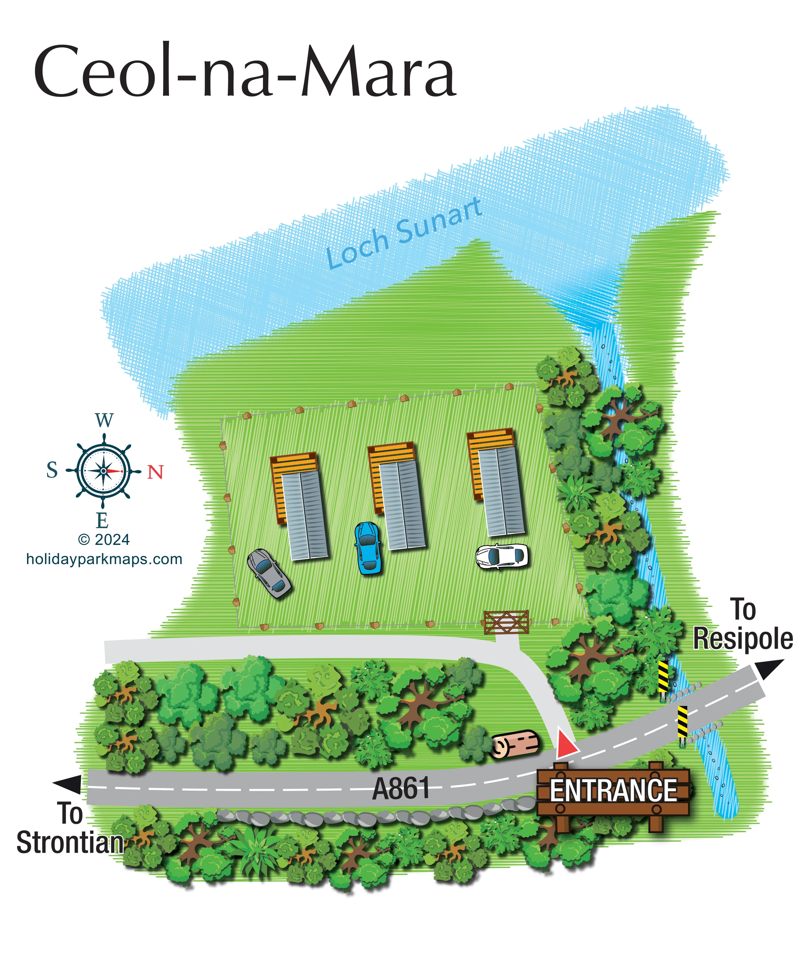
The named loch occupies the upper part of the artwork, immediately beyond the grassy waterside edge.
ILLUSTRATED PARK MAP · P075
Ceol Na Mara, A861, Strontian, Acharacle · United Kingdom
 Enlarge the map ↗
A SENSE OF THE PLACE
This Ceol-na-Mara map depicts a small lochside site beside the A861 near Strontian. Loch Sunart forms the backdrop, with the entrance marked between the directions to Strontian and Resipole.
The artwork shows three units with adjacent parking, a waterside edge and a stream along one boundary. It is presented as a site-map example; the similarly named guesthouse on Harris is a different property.
LOOK CLOSER
The named loch occupies the upper part of the artwork, immediately beyond the grassy waterside edge.
A narrow blue stream runs along the right-hand boundary, beneath the A861 crossing and towards the loch.
Dense illustrated trees flank the stream and line the roadside, separating the accommodation enclosure from the main road.
An open green strip lies between the fenced accommodation area and Loch Sunart.
A line of grey stones follows part of the lower road edge, adding a recognisable boundary detail.
A car is illustrated beside each of the three units, communicating parking close to accommodation rather than a separate communal car park.
A large timber-style ENTRANCE sign and red triangular marker identify the turn from the A861.
The A861 curves across the lower page, with arrows towards Strontian on the left and Resipole on the right.
The named loch occupies the upper part of the artwork, immediately beyond the grassy waterside edge.
A narrow blue stream runs along the right-hand boundary, beneath the A861 crossing and towards the loch.
Dense illustrated trees flank the stream and line the roadside, separating the accommodation enclosure from the main road.
An open green strip lies between the fenced accommodation area and Loch Sunart.
A car is illustrated beside each of the three units, communicating parking close to accommodation rather than a separate communal car park.
A large timber-style ENTRANCE sign and red triangular marker identify the turn from the A861.
The A861 curves across the lower page, with arrows towards Strontian on the left and Resipole on the right.
A pale-grey drive curves inward from the road, reaching the enclosure gate and continuing left along its frontage.
A post-and-wire-style fence outlines the accommodation lawn, with a timber gate near its lower-right corner.
The road crosses the stream beside stone edging and black-and-yellow striped markers.
A line of grey stones follows part of the lower road edge, adding a recognisable boundary detail.
READING THE MAP
This illustrated map of Ceol-na-Mara presents a small lochside site beside the A861 near Strontian. Rather than organising a large park into numbered areas, it concentrates on three accommodation units, their adjacent parking and the short approach from the main road. Loch Sunart stretches across the upper part of the page, while a narrow stream and a dense belt of trees define the right-hand edge.
The entrance is the strongest wayfinding feature: a large timber-style sign and red marker draw attention to the turn from the A861. Arrows towards Strontian and Resipole give the approach a useful local context. Within the site, a pale-grey drive meets a timber gate into the fenced accommodation lawn.
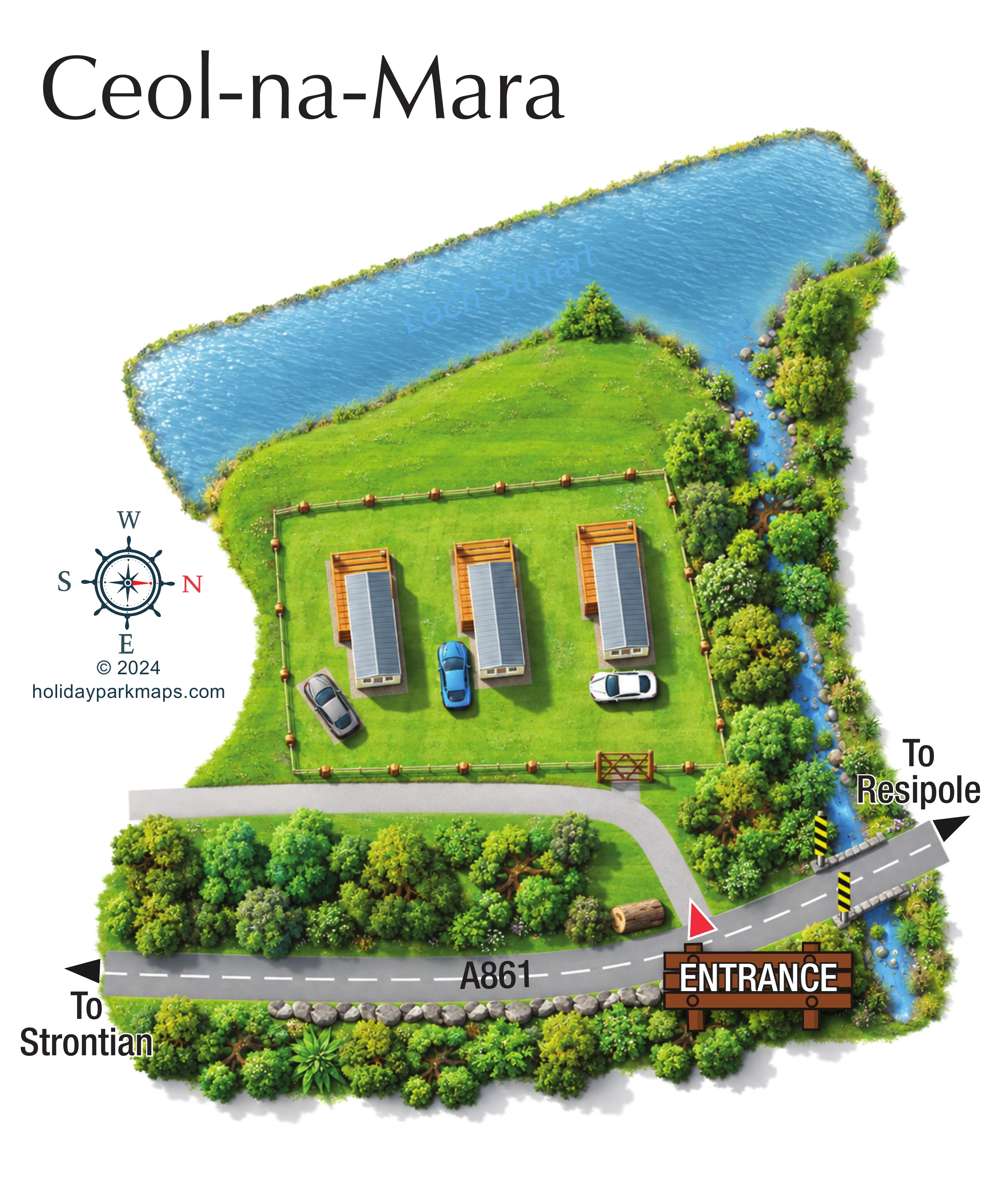
Bright greens, blue water textures and shaded tree illustrations give the plan a distinctly pictorial character. The large title and nautical compass complete a simple portrait composition. This sample is particularly relevant to small accommodation businesses that need to explain arrival, parking and their relationship to a distinctive waterside setting without the complexity of a conventional holiday-park pitch plan.
The map arranges Ceol-na-Mara around a single fenced lawn containing three parallel accommodation units. Each is drawn with an elongated grey pitched roof and an orange-brown, slatted deck-like area towards the loch. Cars in grey, blue and white sit close to the units, making the relationship between accommodation and parking immediately apparent. The enclosure has a timber gate near its lower-right corner, reached by a pale-grey drive that curves up from the A861 and continues left across the frontage.
The main road sweeps across the bottom of the illustration, labelled A861 and marked with a dashed white centre line. Large arrows show the directions to Strontian and Resipole. At the entrance, an oversized illustrated wooden sign carries bold white lettering, supported by a red triangular marker at the junction. To the right, the road crosses a narrow stream, with stones and black-and-yellow markers making the crossing visually distinctive.
Landscape provides much of the map's structure. Loch Sunart occupies the broad upper edge in pale-blue crosshatching, beyond an open grassy margin. The stream runs down the right-hand side through dense trees, while another substantial tree belt separates the site drive from the main road. Grey stones line part of the opposite roadside edge.
The portrait page has a large serif title above the plan and a nautical compass in the left margin, with north pointing right. Parallel green strokes texture the lawns, while dimensional roofs, shaded vehicles and layered tree canopies add depth. There is no numbered key or legend: the design communicates through a small set of recognisable features and prominent labels.
 Enlarge this map ↗
KEEP EXPLORING
Chosen for shared landscapes, accommodation or facilities.
 Explore the map ↗
United Kingdom
A stream-side farm campsite plan with car-free camping, caravan pitches and separate bell-tent areas.
 Explore the map ↗
United Kingdom
Woodland park map with mixed pitches, bell tents, lodges and a fishing lake.
 Explore the map ↗
United Kingdom
Illustrated lakeside park plan with numbered holiday units, leisure buildings and a looping Woodland Walk.
Features may come from the sample artwork, its key or published park information. Approximate numbers describe the drawing and may cover only part of a park. They are intended to help you compare map examples. Current facilities and booking information should be checked with the park.
LET’S MAP YOUR PARK
For a map quotation, find your park and draw a rough boundary around it. The area you select helps us work out the design time and price.
Draw your park for a quote ↗Or talk to our map designers
01751 473136