
Wooded beck corridor
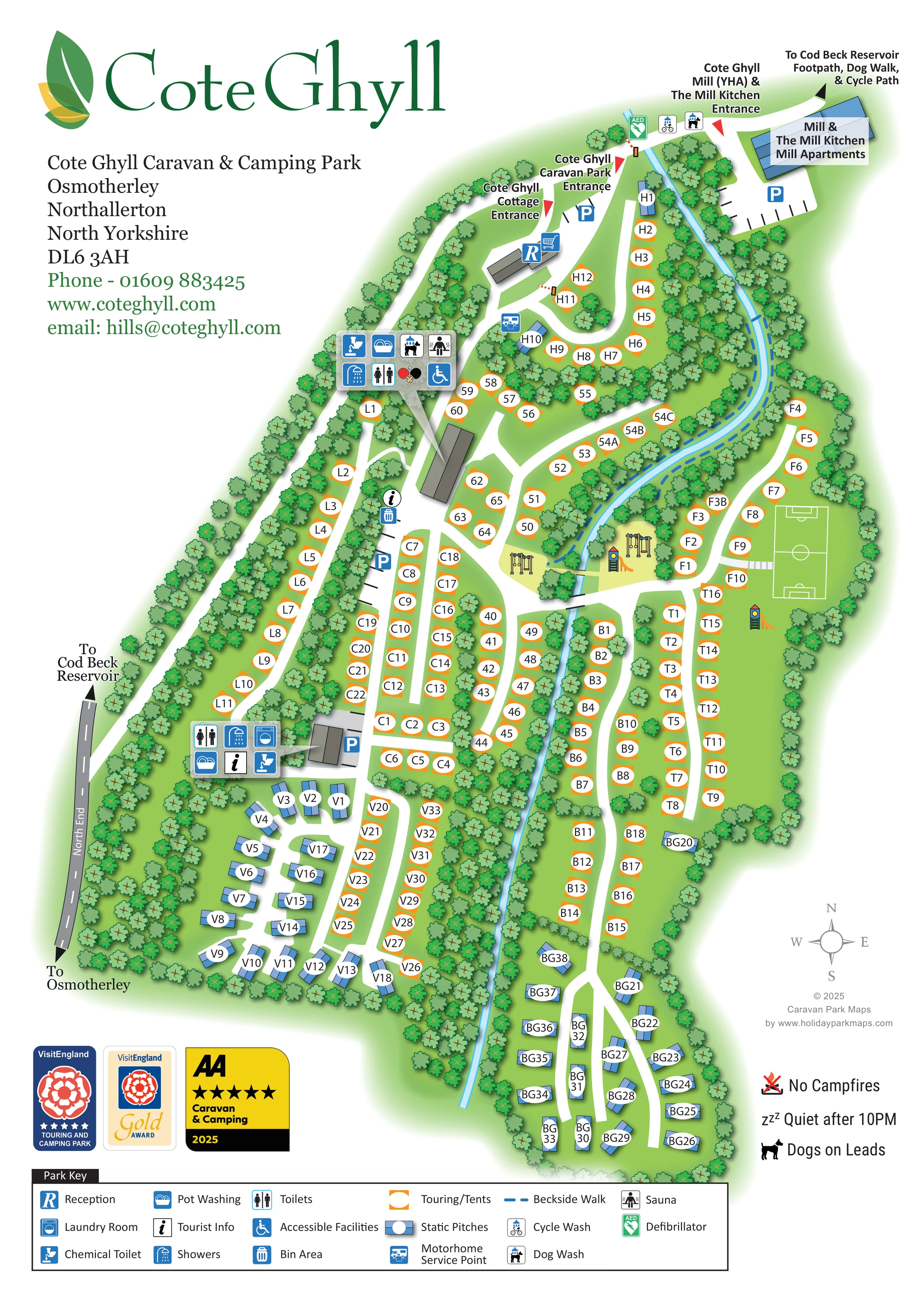
A narrow blue watercourse winds from the upper mill area through the centre of the park, separating several pitch groups.
ILLUSTRATED PARK MAP · P086
Cote Ghyll Caravan & Camping Park, Osmotherley, Northallerton, North Yorkshire · United Kingdom
 Enlarge the map ↗
A SENSE OF THE PLACE
Cote Ghyll Caravan & Camping Park is based at Osmotherley, Northallerton, North Yorkshire. Cote Ghyll identifies its location as the North York Moors National Park. The operator markets touring caravan and camping holidays.
The facilities page describes shower blocks, family shower facilities, accessible washrooms and a reception shop. The Larch Block includes a sauna and a dog washing/grooming station.
LOOK CLOSER
A narrow blue watercourse winds from the upper mill area through the centre of the park, separating several pitch groups.
Dense illustrated trees line the perimeter, follow the beck and subdivide accommodation rows into smaller groups.
Reception and shopping-trolley symbols mark a grey building beside the caravan park entrance.
Two main amenity clusters show toilets and showers; the upper cluster also carries the accessible-facilities symbol.
Pot-washing symbols appear in both main amenity clusters.
A laundry symbol appears beside the lower-left amenity building.
Chemical-toilet symbols are grouped with the upper and lower amenity facilities.
A motorhome service-point symbol is positioned just below reception, near the upper pitch loop.
Reception and shopping-trolley symbols mark a grey building beside the caravan park entrance.
Two main amenity clusters show toilets and showers; the upper cluster also carries the accessible-facilities symbol.
Pot-washing symbols appear in both main amenity clusters.
A laundry symbol appears beside the lower-left amenity building.
Chemical-toilet symbols are grouped with the upper and lower amenity facilities.
A motorhome service-point symbol is positioned just below reception, near the upper pitch loop.
Information symbols appear by the central road and at the lower amenity block.
A bin-area symbol is shown beside the central tourist-information point.
Dog-wash symbols are shown in the upper amenity cluster and near the mill-side entrance.
A cycle-wash symbol appears near the mill entrance and the reservoir route.
The sauna symbol is included in the upper amenity cluster.
A green AED symbol marks a location near the top of the park beside the mill-side approach.
Illustrated swings and slide equipment occupy grassy spaces near the central beck crossing and beside the sports pitch.
A rectangular green playing area with white football-style markings is illustrated on the eastern side.
The Mill Kitchen is named within the upper-right mill complex and its entrance label.
Blue parking symbols and black bay strokes identify parking by reception, the mill and internal amenity areas.
A narrow blue watercourse winds from the upper mill area through the centre of the park, separating several pitch groups.
A dashed blue route follows the upper stretch of the beck and is identified in the key as Beckside Walk.
Short grey crossing structures connect routes across the beck near the central play area.
Dense illustrated trees line the perimeter, follow the beck and subdivide accommodation rows into smaller groups.
Directional labels point towards Cod Beck Reservoir from North End and from the upper-right footpath, dog walk and cycle path.
Red triangular pointers identify the caravan park entrance, cottage entrance and Mill (YHA)/Mill Kitchen entrance.
The grey road along the western side is labelled North End, with arrows towards Osmotherley and Cod Beck Reservoir.
Published park information describes family shower facilities; the map does not distinguish these from its general shower symbols.
READING THE MAP
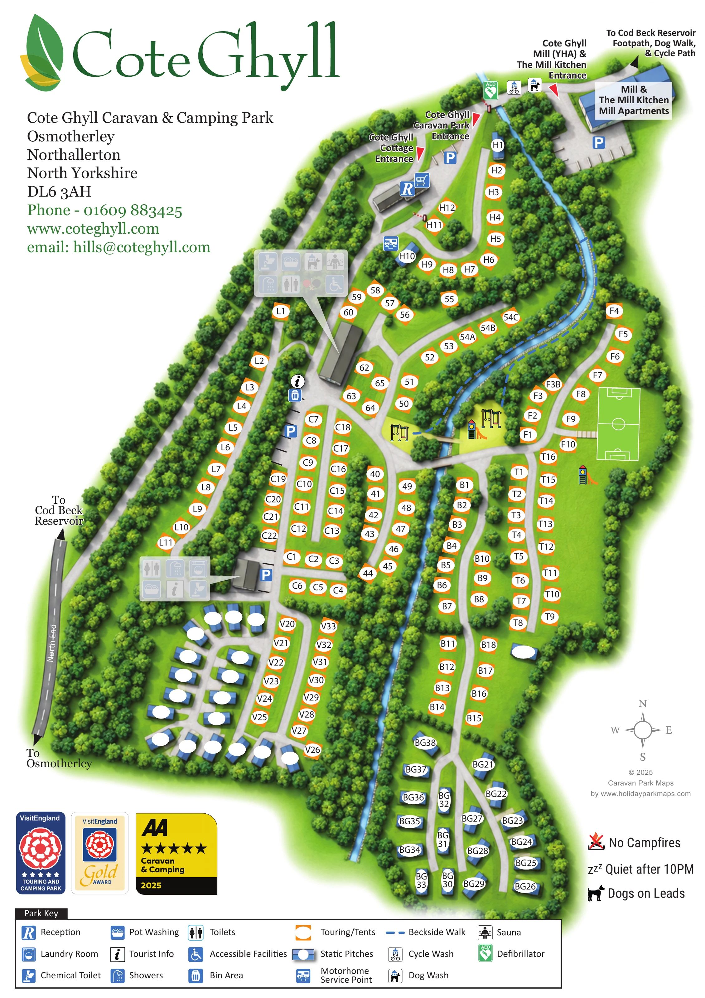
This illustrated map of Cote Ghyll Caravan & Camping Park presents a wooded holiday setting at Osmotherley in North Yorkshire. A winding beck runs through the plan, with touring and tent pitches arranged in small groups along branching internal roads. Blue static-pitch symbols contrast with orange touring markers, making the accommodation mix easy to recognise without losing the individual pitch references needed for arrival.
The portrait composition brings together the caravan park, a separately labelled cottage entrance and the neighbouring mill complex, including The Mill Kitchen and Mill Apartments. Reception, parking and two main amenity clusters are clearly marked, while illustrated play equipment and a sports pitch give visitors useful landmarks within the site. Routes towards Cod Beck Reservoir extend the map's usefulness beyond the accommodation areas.
A large green wordmark, leafy boundaries and a comprehensive symbol key give the artwork a recognisable identity. The result is a practical example of mapping a varied camping and caravan site where woodland, water and several distinct arrival points need to be explained on one page.
The plan follows Cote Ghyll's elongated shape, with North End shown along the western boundary and the main caravan park entrance near the top. Separate red pointers identify the cottage entrance and the entrance serving the mill, YHA and The Mill Kitchen. Reception and a shop symbol sit beside the upper approach, with nearby parking and a motorhome service point.
White internal roads form an upper loop before branching into long accommodation rows. Orange touring/tent markers carry short pitch identifiers inside white panels; blue rectangular symbols identify static pitches, especially in the lower-left and lower-right groups. Trees line the perimeter, screen neighbouring rows and frame the beck as it winds through the centre. Grey crossing structures link the two sides near the recreation spaces.
Two amenity clusters provide useful orientation points. Their symbols identify toilets, showers, pot washing and chemical-toilet facilities, with laundry shown at the lower block and accessible facilities at the upper cluster. The upper facilities also include dog-wash and sauna symbols. Tourist-information points, a bin area and parking locations are marked elsewhere along the internal routes. Near the mill-side approach, the map shows cycle washing, dog washing and a green defibrillator symbol.
Swings and slides are drawn near the central beck crossing, and a marked sports pitch occupies an open eastern area. A dashed blue Beckside Walk follows the upper watercourse, while destination arrows point towards Cod Beck Reservoir, including a labelled footpath, dog walk and cycle path. The full-width key anchors the page below the plan, supported by a compass, rating badges and illustrated conduct reminders. The accompanying detail images enlarge this same key rather than showing additional park sections.
 Enlarge this map ↗
KEEP EXPLORING
Chosen for shared landscapes, accommodation or facilities.
 Explore the map ↗
United Kingdom
A wooded Allerton park plan with colour-coded neighbourhoods, touring pitches and a central facilities hub.
 Explore the map ↗
United Kingdom
A wooded, mixed-accommodation park plan with winding lanes, a pool, camping areas and a clear facility key.
 Explore the map ↗
United Kingdom
Woodland-framed Barnsoul map with mixed accommodation, shared facilities and paw-marked walking routes.
Features may come from the sample artwork, its key or published park information. Approximate numbers describe the drawing and may cover only part of a park. They are intended to help you compare map examples. Current facilities and booking information should be checked with the park.
TAKE A CLOSER LOOK
View the illustrated map in detail or choose a file to download. These are sample maps; contact the park for current visitor information.

LET’S MAP YOUR PARK
For a map quotation, find your park and draw a rough boundary around it. The area you select helps us work out the design time and price.
Draw your park for a quote ↗Or talk to our map designers
01751 473136
 coteghylladoublesided_Page_2.png