
Wild flower viewpoint
Named on the western side of the park, beside illustrated flowers, play equipment, picnic seating and outdoor exercise facilities.
ILLUSTRATED PARK MAP · P084
Llanrwst Road, Conwy, North Wales · United Kingdom
 Enlarge the map ↗
A SENSE OF THE PLACE
Conwy Holiday Park offers touring caravan stays overlooking the Conwy estuary and valley. Secluded pitch areas sit within extensive grounds, with views towards the mountains of Eryri.
Public footpaths lead towards Conwy, and a bus stop at the park provides another way to explore the area. The location combines a countryside setting with access to the historic town and the North Wales coast.
LOOK CLOSER
Named on the western side of the park, beside illustrated flowers, play equipment, picnic seating and outdoor exercise facilities.
Dense repeated tree symbols surround the pitch areas, follow roads and define the park perimeter. Hedge-like planting separates several lodge roads.
Marked beside the lower-right arrival road, near parking, the lodge ownership suite and a defibrillator.
Prominently labelled and illustrated in the upper-left part of the park, with its own branded sign and nearby outdoor play equipment.
Playground illustrations appear beside the clubhouse, near the western viewpoint and beside Purple B.
A football symbol identifies a recreation area beside the play and picnic facilities near Purple B.
Picnic-table symbols appear near the western viewpoint and beside the Purple B recreation area.
Exercise symbols are shown beside the western viewpoint facilities and in the recreation cluster near Purple B.
Marked beside the lower-right arrival road, near parking, the lodge ownership suite and a defibrillator.
Prominently labelled and illustrated in the upper-left part of the park, with its own branded sign and nearby outdoor play equipment.
Playground illustrations appear beside the clubhouse, near the western viewpoint and beside Purple B.
A football symbol identifies a recreation area beside the play and picnic facilities near Purple B.
Picnic-table symbols appear near the western viewpoint and beside the Purple B recreation area.
Exercise symbols are shown beside the western viewpoint facilities and in the recreation cluster near Purple B.
A dog symbol marks this combined facility beside the curved road north of the Purple pitch groups.
Repeated blue amenity symbols serve the Blue, White, Purple and Green pitch areas.
Wheelchair symbols accompany amenity points near the White pitches and the northern Green area; the map does not specify their individual provisions.
Located at the illustrated service-building group north of the Purple pitches.
A dedicated disposal symbol is positioned beside the amenity point within the Purple area.
Green recycling symbols are distributed around the principal pitch sections.
Red circular fire-point symbols recur throughout the numbered pitch groups.
Blue parking signs identify spaces near reception and the clubhouse.
Marked on the main internal approach beside the southern end of the Purple pitches.
A green AED symbol appears beside reception.
A spanner symbol identifies a building within the service compound north of the Purple area.
A blue key symbol marks the suite on the arrival-side road near reception.
Named on the western side of the park, beside illustrated flowers, play equipment, picnic seating and outdoor exercise facilities.
Dense repeated tree symbols surround the pitch areas, follow roads and define the park perimeter. Hedge-like planting separates several lodge roads.
A brown dotted loop runs through the western woodland beside the viewpoint.
Grey dashed paths connect western woodland, lodge areas and recreation spaces, with further routes across the southern and eastern grounds.
A red arrow identifies the entrance on the right-hand road; black arrows indicate directions towards Llanrwst and Conwy.
A bus-stop symbol is shown on the external road close to the entrance.
Pale grey main roads form the circulation network, while turquoise, pink and dark green area roads distinguish pitch sections.
READING THE MAP
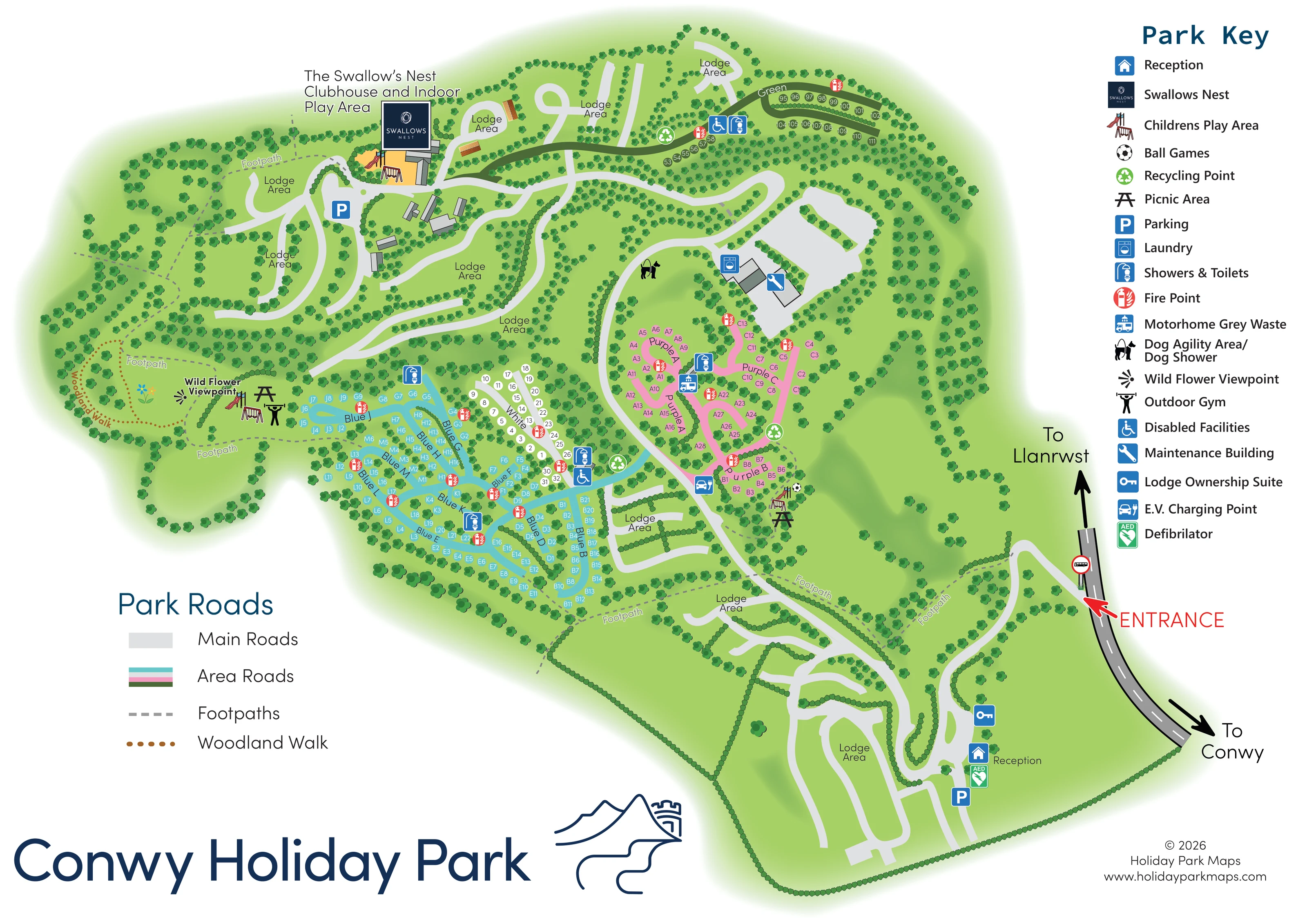
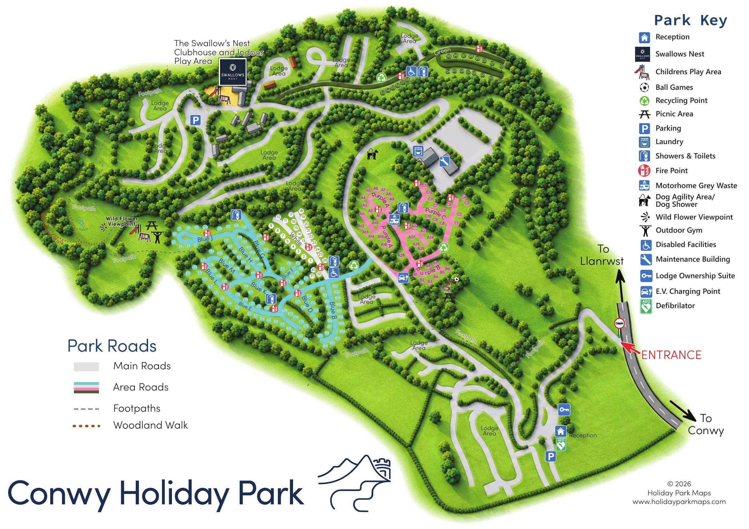
This illustrated map of Conwy Holiday Park brings together numbered touring pitches, lodge areas and woodland routes in a single overview. Set on Llanrwst Road in North Wales, the park is introduced through a clearly marked entrance, reception and roadside directions towards Conwy and Llanrwst. From there, the drawing opens into a network of curving roads, tree-lined accommodation areas and walking paths.
The map’s strongest organising device is its colour-coded pitch layout. Turquoise Blue sections, pink Purple sections and a dark green northern loop stand apart from the pale main roads, with a smaller White pitch group between them. Lodge areas occupy several surrounding branches and loops. The Swallow’s Nest clubhouse and indoor play area provides a prominent landmark, while the western wild flower viewpoint brings together woodland walking and outdoor recreation.
A large facility key and a separate route key support the detailed plan without crowding its centre. The result is a useful sample for parks that need to explain several accommodation zones, distributed amenities and landscaped grounds on one page.
The plan places the entrance on the right-hand edge, where a dark external road carries arrows towards Llanrwst and Conwy. A red entrance arrow leads into the pale grey internal road network. Reception, parking, the lodge ownership suite and an AED marker sit along the lower-right arrival section, before the road curves into the wider park.
The largest concentration of numbered pitches lies left of centre. Turquoise roads divide the Blue area into smaller named branches, with a narrow White section alongside. Pink roads organise the Purple pitches to the right, while the Green area occupies a separate loop across the upper part of the drawing. Circular pitch markers communicate locations without filling the plan with vehicle illustrations. Around these groups, repeated Lodge Area labels identify quieter-looking road loops and branches, framed by trees and hedge-like planting.
The Swallow’s Nest clubhouse and indoor play area is illustrated towards the upper left, accompanied by outdoor play equipment and nearby parking. A service-building group north of the Purple pitches carries laundry and maintenance symbols. Shower and toilet points, disabled-facility markers, recycling points and fire points are distributed through the accommodation sections. Other mapped amenities include motorhome grey-waste disposal, electric vehicle charging and a dog agility area and dog shower.
Walking routes add another layer. Grey dashed footpaths cross the grounds, while a brown dotted woodland circuit leads around the western wild flower viewpoint. Playground, picnic and outdoor gym symbols appear here and near Purple B, where ball games are also marked. The single-page composition is supported by a tall facility legend on the right and a road key at lower left.
 Enlarge this map ↗
KEEP EXPLORING
Chosen for shared landscapes, accommodation or facilities.
 Explore the map ↗
United Kingdom
Woodland-framed Barnsoul map with mixed accommodation, shared facilities and paw-marked walking routes.
 Explore the map ↗
United Kingdom
Woodland park map with mixed pitches, bell tents, lodges and a fishing lake.
 Explore the map ↗
United Kingdom
A wooded, streamside park map with a linked farm, café, touring and cottage area.
Features may come from the sample artwork, its key or published park information. Approximate numbers describe the drawing and may cover only part of a park. They are intended to help you compare map examples. Current facilities and booking information should be checked with the park.
TAKE A CLOSER LOOK
View the illustrated map in detail or choose a file to download. These are sample maps; contact the park for current visitor information.


LET’S MAP YOUR PARK
For a map quotation, find your park and draw a rough boundary around it. The area you select helps us work out the design time and price.
Draw your park for a quote ↗Or talk to our map designers
01751 473136