
Tree and shrub boundaries
Dense illustrated trees and shrubs enclose much of the campsite, especially its western and southern edges.
ILLUSTRATED PARK MAP · P088
15 Welford Road, Barton, Alcester · United Kingdom
 Enlarge the map ↗
A SENSE OF THE PLACE
Cottage of Content is a pub with an adjoining campsite at Barton near Alcester in Warwickshire. The setting brings a small camping area together with a village pub.
Food, real ales and entertainment are offered by the pub, while the camping information also advertises electric connections and Wi-Fi. The map helps visitors understand the relationship between the pitches and the shared pub facilities.
LOOK CLOSER
Dense illustrated trees and shrubs enclose much of the campsite, especially its western and southern edges.
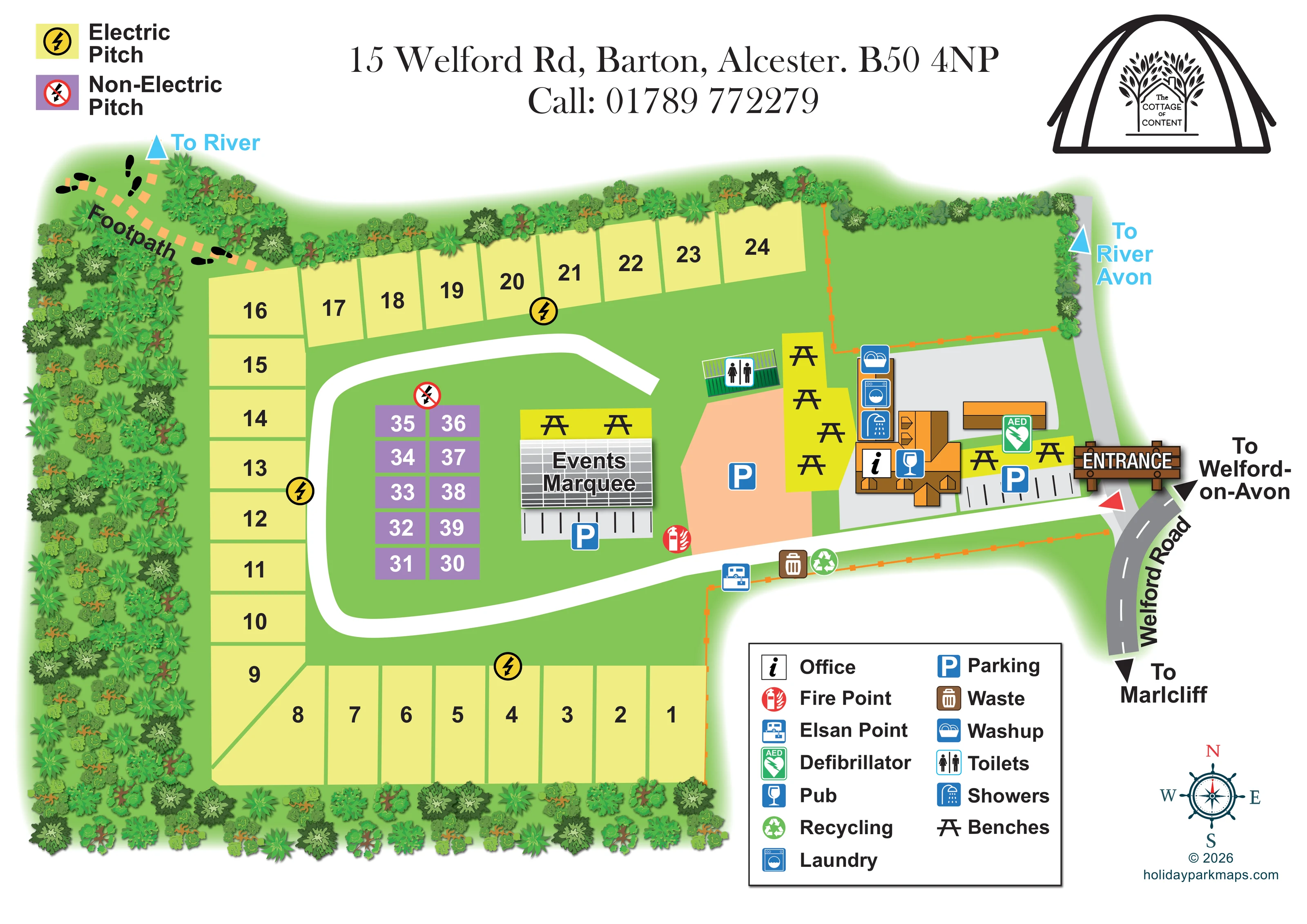
An unnumbered green area north of the pub is edged by planting and orange fence lines; no specific accommodation or activity use is labelled.
An orange-roofed building near the entrance carries the pub symbol and forms the focal point of the shared facilities.
The office information symbol is positioned on the pub building.
A labelled grey marquee stands between the central non-electric pitches and the main parking area.
Parking is marked beside the pub, in a larger peach-coloured area to its west, and immediately below the events marquee.
A toilet symbol marks a small green-roofed building between the camping area and the pub-side parking.
A shower symbol appears on the narrow service-building strip beside the pub.
An orange-roofed building near the entrance carries the pub symbol and forms the focal point of the shared facilities.
The office information symbol is positioned on the pub building.
A labelled grey marquee stands between the central non-electric pitches and the main parking area.
Parking is marked beside the pub, in a larger peach-coloured area to its west, and immediately below the events marquee.
A toilet symbol marks a small green-roofed building between the camping area and the pub-side parking.
A shower symbol appears on the narrow service-building strip beside the pub.
The laundry symbol is grouped with the showers and washing-up facilities beside the pub.
A dishwashing symbol marks the upper end of the pub-side service strip.
The chemical-disposal symbol is placed beside the lower internal access route, west of the waste and recycling symbols.
Waste and recycling symbols are grouped along the lower boundary beside the internal access route.
A red fire-point symbol is shown beside the route between the marquee and the main parking area.
A green AED symbol marks a location beside a small outbuilding near the pub and entrance.
Picnic-table-style bench symbols occupy bright yellow areas beside the pub and above the events marquee.
Pale-yellow pitch plots and repeated lightning symbols distinguish the electric perimeter pitches from the purple non-electric group.
A large illustrated entrance sign identifies access beside the pub on the eastern edge of the campsite.
A broad white route leads west from the entrance, curves around the central pitches and continues towards the northern electric row.
An orange dashed footpath with black footprint motifs leaves the north-western corner towards a blue 'To River' arrow.
A second blue directional label points towards the River Avon beyond the north-eastern edge. The river itself is not drawn.
The curved grey road is labelled Welford Road, with arrows towards Welford-on-Avon and Marlcliff.
Dense illustrated trees and shrubs enclose much of the campsite, especially its western and southern edges.
An unnumbered green area north of the pub is edged by planting and orange fence lines; no specific accommodation or activity use is labelled.
READING THE MAP
This illustrated map presents Cottage of Content Campsite as a compact camping area adjoining a village pub in Barton near Alcester, Warwickshire. Its main task is to make the relationship between the pitches, the pub and the shared visitor facilities immediately understandable.
Pale-yellow electric pitches wrap around three sides of the grounds, while a smaller purple group identifies the non-electric pitches near the centre. A broad white internal route links the entrance on Welford Road with the camping area, passing parking, the events marquee and the pub-side amenities. Trees and shrubs form a richly illustrated boundary, giving the plan a green, enclosed character without obscuring the numbered plots.
The map also looks beyond the campsite: road arrows point towards Welford-on-Avon and Marlcliff, and a footprint-marked footpath leads towards the river. A separate River Avon direction appears on the opposite side. With its tent-framed pub logo, large entrance sign and clearly keyed service symbols, this sample combines local identity with practical orientation for a small pub campsite.
The single landscape-format plan places the campsite across the left and centre of the page, with Welford Road curving down the right-hand edge. An illustrated timber entrance sign marks the access beside the pub. From here, the broad white internal route runs west past the facilities, bends around the central camping area and continues towards the northern pitch row.
The accommodation layout is deliberately simple. Pale-yellow electric pitches follow the southern, western and northern boundaries, while purple non-electric pitches form a compact two-column block inside the site. Large numbers make individual plots easy to locate, and a separate upper-left key explains the pitch colours and electrical symbols. The pitches are drawn as spaces, rather than populated with tents or vehicles.
Shared facilities cluster around the orange-roofed pub on the eastern side. The office and pub symbols sit on the main building, with washing-up, laundry and shower symbols grouped beside it. A separate green-roofed toilet building stands farther west. Parking is identified beside the pub, in a larger peach-coloured area and beneath the labelled events marquee. Bench symbols mark outdoor seating around the pub and marquee. The plan also locates an AED, a fire point, an Elsan point, waste and recycling.
Dense foliage illustrations border the grounds, while an orange dashed footpath with black footprints leaves the north-western corner towards the river. Blue arrows provide river directions without depicting the water itself. The large boxed facilities legend, compass rose, top-line contact details and tent-shaped logo complete the composition, balancing a practical site diagram with recognisable pub and campsite branding.
KEEP EXPLORING
Chosen for shared landscapes, accommodation or facilities.
 Explore the map ↗
United Kingdom
Illustrated coastal campsite plan with named fields, electric pitch colours, beach routes and the Afon Hen.
 Explore the map ↗
United Kingdom
Colour-coded campsite map with riverside pitches, bell tents, a swimming pool and fishing lake.
 Explore the map ↗
United Kingdom
Woodland camping, lodges, lakes and colour-coded bike trails at Avon Tyrrell Outdoor Centre.
Features may come from the sample artwork, its key or published park information. Approximate numbers describe the drawing and may cover only part of a park. They are intended to help you compare map examples. Current facilities and booking information should be checked with the park.
TAKE A CLOSER LOOK
View the illustrated map in detail or choose a file to download. These are sample maps; contact the park for current visitor information.

LET’S MAP YOUR PARK
For a map quotation, find your park and draw a rough boundary around it. The area you select helps us work out the design time and price.
Draw your park for a quote ↗Or talk to our map designers
01751 473136