
Landscaped water garden
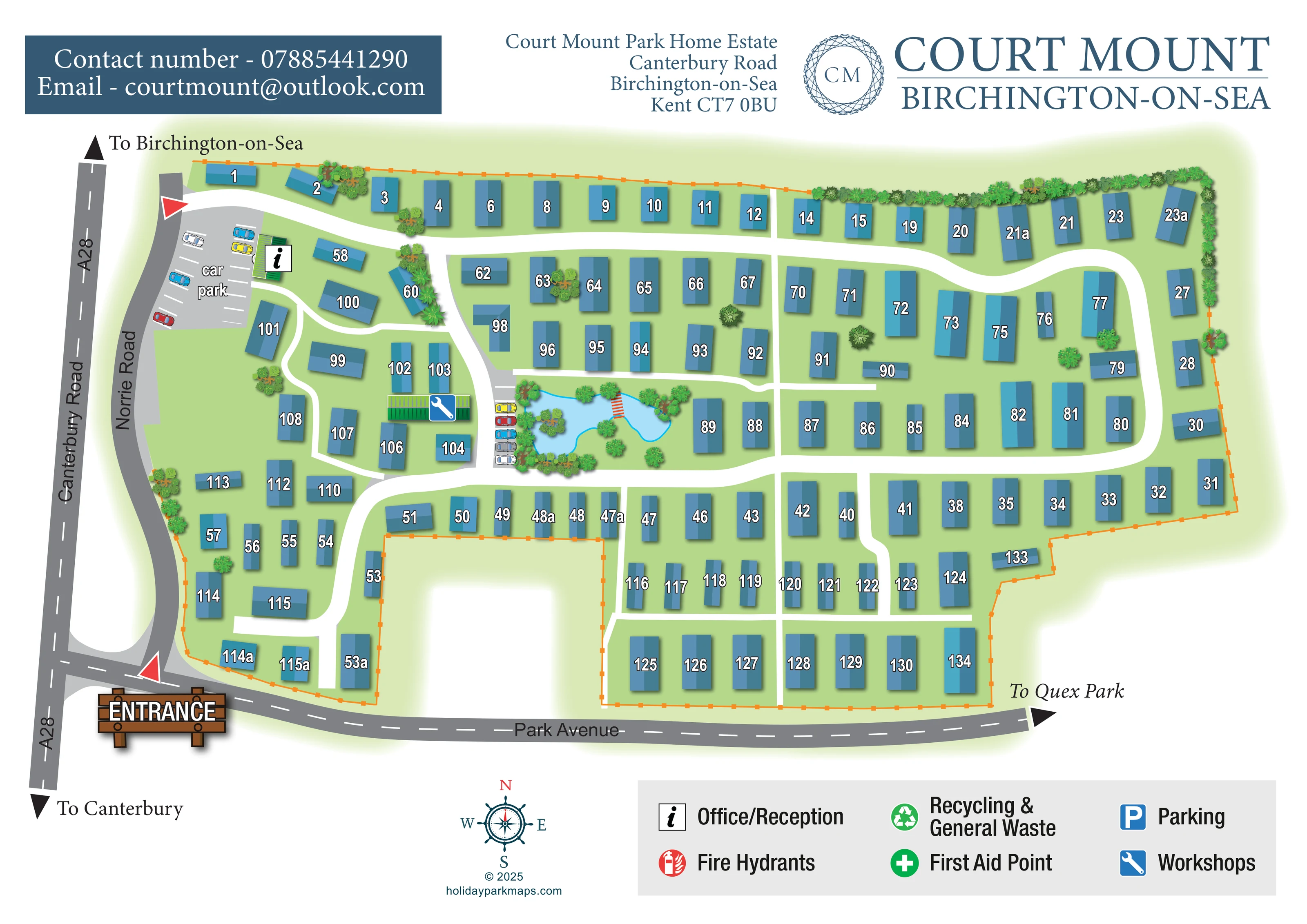
An irregular pale-blue water feature occupies a central-western green space, surrounded by illustrated trees and shrubs.
ILLUSTRATED PARK MAP · P089
Canterbury Road, Birchington-on-Sea, Kent · United Kingdom
 Enlarge the map ↗
A SENSE OF THE PLACE
Court Mount is a residential park home estate at Birchington-on-Sea in Kent. Landscaped grounds and a water garden give the estate its character.
Individual homes have their own gardens, and the operator describes a community aimed at retired and semi-retired people over 55. The map presents the layout of the homes and access routes within the grounds.
LOOK CLOSER
An irregular pale-blue water feature occupies a central-western green space, surrounded by illustrated trees and shrubs.
Pale-green grounds surround the homes, with scattered ornamental planting and a denser belt of shrubs along the northern and eastern edges.
An orange line with small square markers traces the irregular estate perimeter, including a pronounced recess along the southern side.
An information symbol marks a green-roofed building beside the main car park on the western side.
A labelled car park with bay markings and illustrated cars sits beside Norrie Road. A smaller line of parking bays is shown beside the water garden.
A blue spanner symbol identifies a long green-roofed workshop building west of the water garden.
A small orange slatted bridge crosses a narrow section of the water garden.
A large illustrated wooden ENTRANCE sign marks the south-western approach near the Canterbury Road and Park Avenue junction.
An information symbol marks a green-roofed building beside the main car park on the western side.
A labelled car park with bay markings and illustrated cars sits beside Norrie Road. A smaller line of parking bays is shown beside the water garden.
A blue spanner symbol identifies a long green-roofed workshop building west of the water garden.
An irregular pale-blue water feature occupies a central-western green space, surrounded by illustrated trees and shrubs.
A small orange slatted bridge crosses a narrow section of the water garden.
Pale-green grounds surround the homes, with scattered ornamental planting and a denser belt of shrubs along the northern and eastern edges.
A large illustrated wooden ENTRANCE sign marks the south-western approach near the Canterbury Road and Park Avenue junction.
Canterbury Road is labelled A28 along the western edge; Norrie Road curves beside the estate and Park Avenue follows its southern edge.
Broad white routes form a long loop around the northern and eastern homes, with connecting branches and narrower cross-links between residential rows.
Black arrows identify onward directions along the bordering roads. Quex Park is a directional reference, not a facility within the estate.
An orange line with small square markers traces the irregular estate perimeter, including a pronounced recess along the southern side.
Listed in the key with a red fire-equipment symbol; no corresponding location is clearly marked on the plan.
Included in the legend with a green recycling symbol, without a clearly identifiable mapped position.
A green cross appears in the legend, but its position is not clearly indicated within the estate.
READING THE MAP
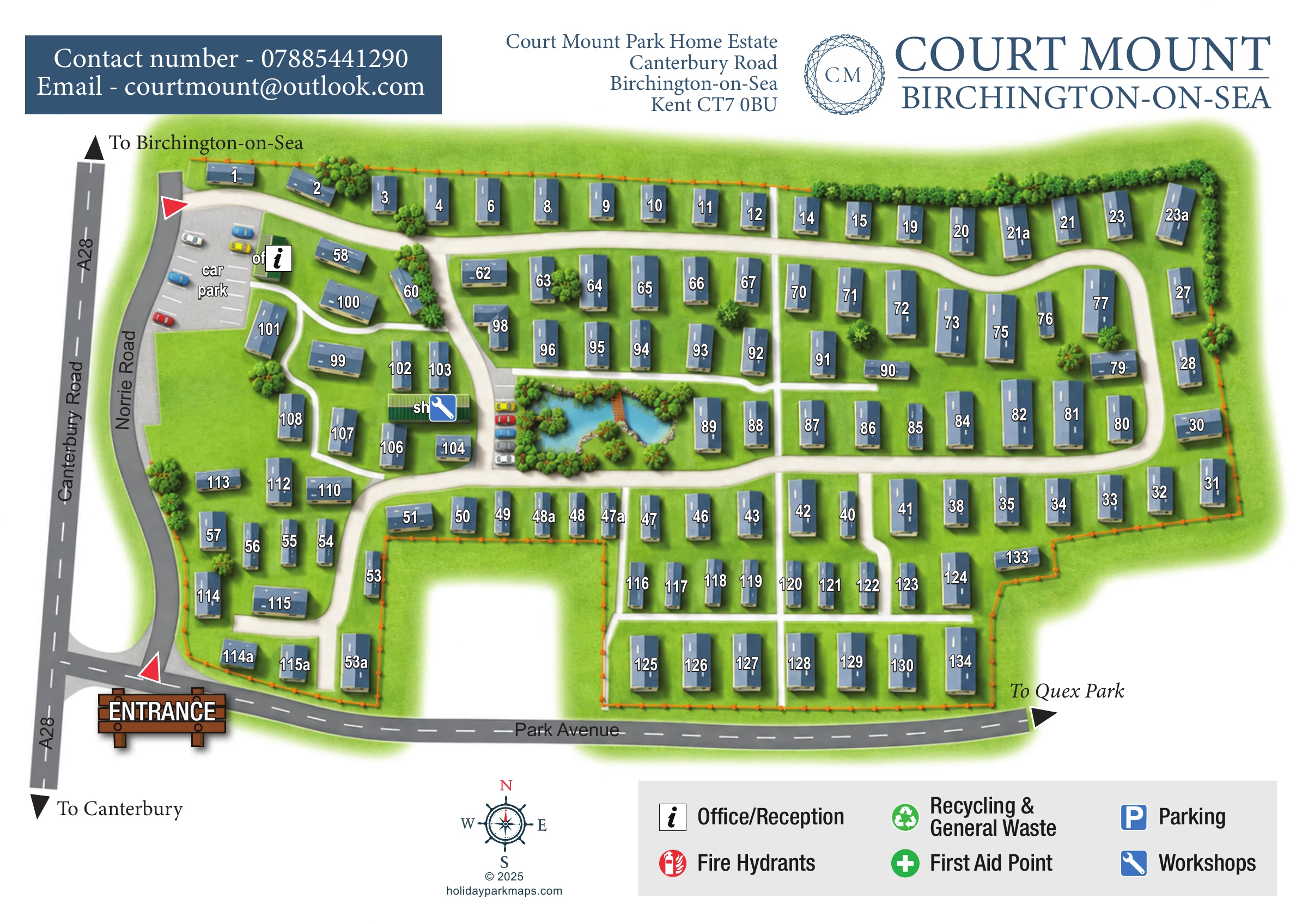
This illustrated map of Court Mount Park Home Estate presents a residential community in Birchington-on-Sea, Kent, through a clear overhead plan. Around 110 individual homes are shown as blue roof shapes, each carrying a prominent address number. White internal routes connect the residential rows, while the surrounding Canterbury Road, Norrie Road and Park Avenue give the estate an immediately recognisable local framework.
The landscaped water garden provides a distinctive focal point within the plan. Pale-blue water, an orange bridge and clusters of trees make this shared green space easy to recognise amongst the homes. Practical destinations are also visible: the office sits beside the western car park, and a spanner symbol identifies the nearby workshops.
A large wooden entrance sign anchors the south-western approach, with arrows pointing towards Birchington-on-Sea, Canterbury and Quex Park. Formal blue branding, a compass rose and a separate facility key complete the page. This sample is particularly relevant to residential park-home estates that need to communicate individual addresses, arrival routes and landscaped surroundings in one coherent illustration.
The plan follows Court Mount’s elongated, irregular outline, with Canterbury Road running down the left and Park Avenue curving across the bottom. Norrie Road sits between the western homes and the A28. An illustrated entrance sign highlights the south-western approach, while black arrows explain the onward directions towards Canterbury, Birchington-on-Sea and Quex Park.
Within the estate, broad white routes form a long loop past the northern row of homes and around the eastern end. Branching routes serve the more loosely arranged western homes, and narrower cross-links divide the central and southern residential rows. The orange perimeter line follows the estate’s changing shape, including a deep recess along its southern edge. Each home is drawn as a blue roof footprint with a large outlined white number, keeping address identification visually separate from the road names and facility labels.
The western car park contains marked bays and small coloured car illustrations. An information icon identifies the office/reception building alongside it. Further into the estate, a green-roofed workshop carries a blue spanner symbol. A second group of parking bays adjoins the landscaped water garden, where an irregular blue water feature, a small orange bridge and clustered planting create a memorable landmark.
The upper margin holds the estate’s contact panel, address and large Court Mount wordmark with its circular CM emblem. Below the plan, a compass rose balances a six-entry facility key. The key also includes fire hydrants, recycling and general waste, and a first aid point, although their positions are not clearly marked in the illustration. The complete artwork is a single estate plan; its enlarged detail views show overlapping portions of that same composition.
 Enlarge this map ↗
KEEP EXPLORING
Chosen for shared landscapes, accommodation or facilities.
 Explore the map ↗
United Kingdom
Illustrated Sanday aire map with a seasonal maze, café barn and motorhome service area.
 Explore the map ↗
United Kingdom
Illustrated coastal campsite plan with named fields, electric pitch colours, beach routes and the Afon Hen.
 Explore the map ↗
United Kingdom
A woodland touring-park map with colour-coded pitches, a stream and footprint-marked walks.
Features may come from the sample artwork, its key or published park information. Approximate numbers describe the drawing and may cover only part of a park. They are intended to help you compare map examples. Current facilities and booking information should be checked with the park.
LET’S MAP YOUR PARK
For a map quotation, find your park and draw a rough boundary around it. The area you select helps us work out the design time and price.
Draw your park for a quote ↗Or talk to our map designers
01751 473136