
Eddleston Water River
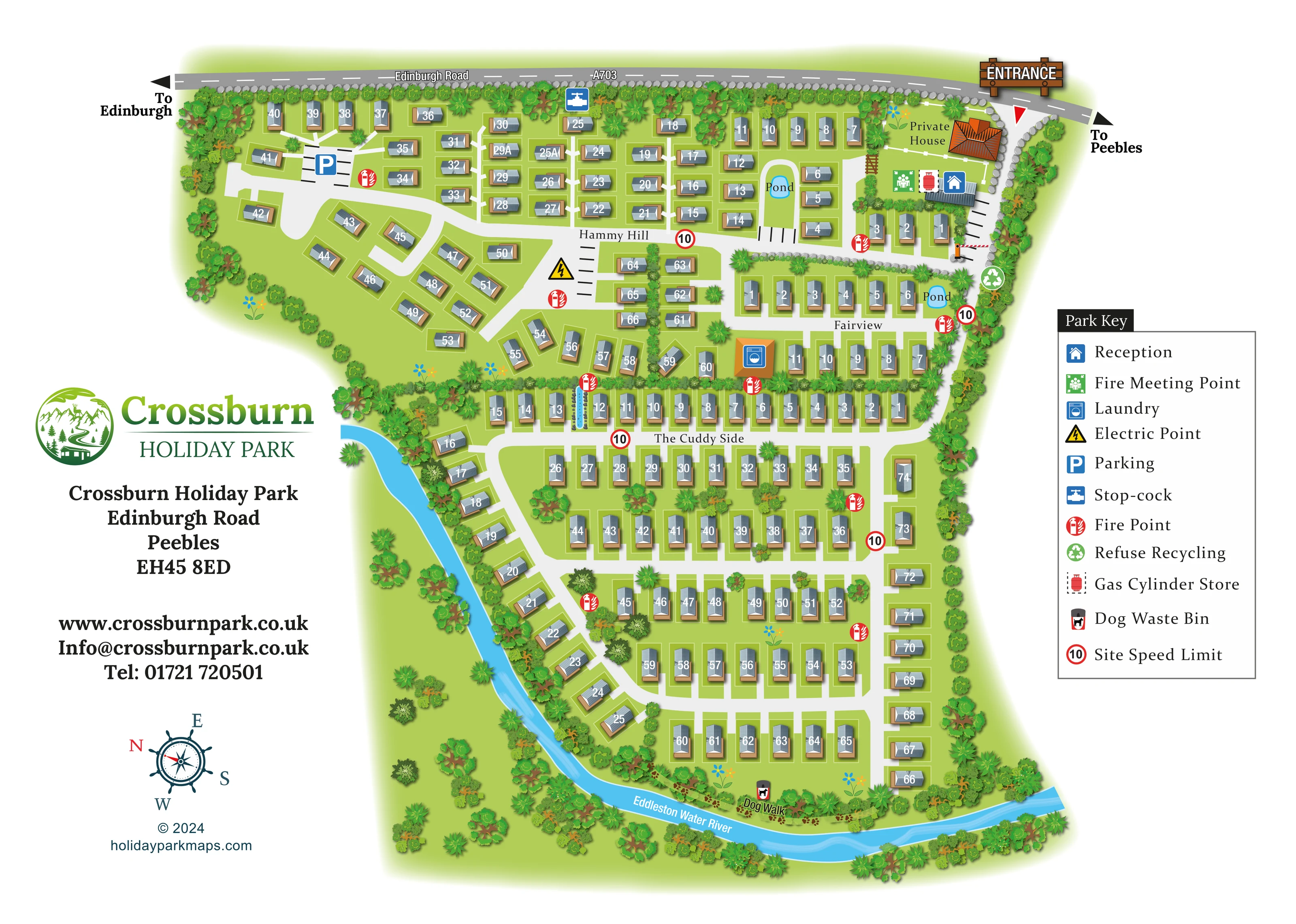
A bright blue river follows the western side of the lower accommodation area and curves across the bottom boundary.
ILLUSTRATED PARK MAP · P094
Crossburn Holiday Park, Edinburgh Road, Peebles · United Kingdom
 Enlarge the map ↗
A SENSE OF THE PLACE
Crossburn Holiday Park offers holiday home and lodge ownership on Edinburgh Road in Peebles. The family-run park occupies a countryside setting in the Scottish Borders.
Peebles provides a nearby historic town to explore, with the wider Borders offering further outings. The park's map gives owners and visitors an overview of the accommodation areas and internal access routes.
LOOK CLOSER
A bright blue river follows the western side of the lower accommodation area and curves across the bottom boundary.
Two small blue ponds are labelled: one within the upper-right accommodation group and another at the eastern end of Fairview.
Dense illustrated planting encloses much of the park, separates accommodation areas and follows the river; scattered trees and flower motifs occupy the green spaces.
A blue house symbol identifies reception in the building cluster beside the entrance at the upper right.
An orange-roofed laundry building is marked between Fairview and the upper row of The Cuddy Side.
A blue parking symbol marks a bay area in the upper-left accommodation section; additional black bay markings appear near the entrance and along internal roads.
A green recycling symbol marks the facility on the eastern access road, below the entrance buildings.
A red cylinder symbol identifies storage beside reception.
A blue house symbol identifies reception in the building cluster beside the entrance at the upper right.
An orange-roofed laundry building is marked between Fairview and the upper row of The Cuddy Side.
A blue parking symbol marks a bay area in the upper-left accommodation section; additional black bay markings appear near the entrance and along internal roads.
A green recycling symbol marks the facility on the eastern access road, below the entrance buildings.
A red cylinder symbol identifies storage beside reception.
A green assembly-point symbol appears alongside the entrance-side building cluster.
Repeated red fire-point symbols are distributed through the accommodation areas and beside service routes.
A yellow electrical warning symbol appears at the central road junction in Hammy Hill. The key calls it an electric point; it is not presented as vehicle charging.
A blue tap symbol identifies a stop-cock near the Edinburgh Road boundary.
A dog waste bin is marked beside the riverside dog walk at the bottom of the plan.
Red-ringed signs bearing 10 recur beside internal roads. These are depicted map signs rather than a statement of current operating rules.
A prominent timber-style entrance sign, red pointer and illustrated barrier identify arrival from the A703 at the upper right.
The road runs across the top of the artwork, with directional arrows towards Edinburgh on the left and Peebles on the right.
Three area names divide the numbered accommodation into a broad upper section, a smaller eastern section and the large lower riverside section.
A bright blue river follows the western side of the lower accommodation area and curves across the bottom boundary.
Two small blue ponds are labelled: one within the upper-right accommodation group and another at the eastern end of Fairview.
A labelled dog-walking strip with paw-print decoration follows part of the southern riverbank.
Dense illustrated planting encloses much of the park, separates accommodation areas and follows the river; scattered trees and flower motifs occupy the green spaces.
A separately labelled orange-roofed private house stands beside the entrance and is visually distinguished from the numbered holiday homes.
READING THE MAP
This illustrated map of Crossburn Holiday Park in Peebles brings together numbered holiday homes, named accommodation areas and a distinctive riverside setting. Edinburgh Road runs across the top of the page, with the entrance clearly marked beside reception. Below it, Hammy Hill, Fairview and The Cuddy Side each have their own arrangement of roads and units, giving visitors useful names as well as individual plot numbers to navigate by.
The Eddleston Water curves around the lower part of the park, while two small ponds and extensive illustrated planting provide additional landmarks. A labelled dog walk follows part of the southern riverbank. Practical information is woven into the plan through symbols for laundry, parking, recycling, fire points and other site infrastructure, explained in a generous key on the right.
The design pairs a largely overhead layout with shaded buildings, textured roofs and layered trees. Green Crossburn branding and a clear address block occupy the open space on the left, producing a single-page map that combines arrival information, accommodation finding and a recognisable picture of the park's landscape.
The plan is organised around three named sections. Hammy Hill fills much of the upper-left area, where short rows and angled groups of holiday homes sit around branching roads. Fairview forms a smaller group on the eastern side, close to a pond and the laundry building. The Cuddy Side occupies the long lower portion, with parallel rows, connecting cross streets and a diagonal riverside line of homes. Each illustrated unit carries a white number on its grey roof, with a pale plot outline and brown base or decking detail.
Arrival is shown at the upper-right corner from Edinburgh Road, labelled A703. A timber-style entrance sign, directional pointer and barrier distinguish this access. Reception, the fire meeting point and gas cylinder store are grouped nearby, while a separately labelled private house sits above them. External road arrows point towards Edinburgh and Peebles. The internal road network extends south from the entrance and branches across the accommodation areas.
A large right-hand key explains the symbols for reception, laundry, parking, stop-cock, electric point, fire points, refuse and recycling, gas storage, dog waste bin and site speed limit. Repeated fire-point and speed-sign symbols are placed beside the roads, while parking bay markings add detail to several junctions and building frontages.
The blue Eddleston Water sweeps down the western edge of the lower park and across its southern boundary. Trees and shrubs follow the river and enclose much of the site. Two labelled ponds break up the upper accommodation area, and a paw-print dog-walk strip appears beside the southern riverbank. The overview presents the complete composition; the accompanying detail enlargement makes the same key and eastern accommodation rows easier to read without introducing a separate map variant.
KEEP EXPLORING
Chosen for shared landscapes, accommodation or facilities.
 Explore the map ↗
United Kingdom
A woodland estate park map combining caravan loops, touring pitches, riverside paths and Bruce’s Cave landmarks.
 Explore the map ↗
United Kingdom
Illustrated lakeside park plan with numbered holiday units, leisure buildings and a looping Woodland Walk.
 Explore the map ↗
United Kingdom
Numbered holiday homes, a riverside border setting and a dedicated dog exercise field at Foggy Bottom.
Features may come from the sample artwork, its key or published park information. Approximate numbers describe the drawing and may cover only part of a park. They are intended to help you compare map examples. Current facilities and booking information should be checked with the park.
LET’S MAP YOUR PARK
For a map quotation, find your park and draw a rough boundary around it. The area you select helps us work out the design time and price.
Draw your park for a quote ↗Or talk to our map designers
01751 473136