
Trees, shrubs and planted boundaries
Dense mixed foliage defines the perimeter, separates caravan rows and encloses the eco accommodation and camping strip.
ILLUSTRATED PARK MAP · P120
Findhorn Bay Holiday Park, The Park, Findhorn, Forres · United Kingdom
 Enlarge the map ↗
A SENSE OF THE PLACE
Findhorn Bay Holiday Park offers holiday accommodation and touring stays near Findhorn on the Moray coast. Its eco lodges are positioned to take advantage of views across the bay.
Self-catering lodge accommodation provides space for families and small groups, with the changing waterside scenery central to the experience. The park map helps guests understand how the accommodation and touring areas are arranged within the site.
LOOK CLOSER
Dense mixed foliage defines the perimeter, separates caravan rows and encloses the eco accommodation and camping strip.
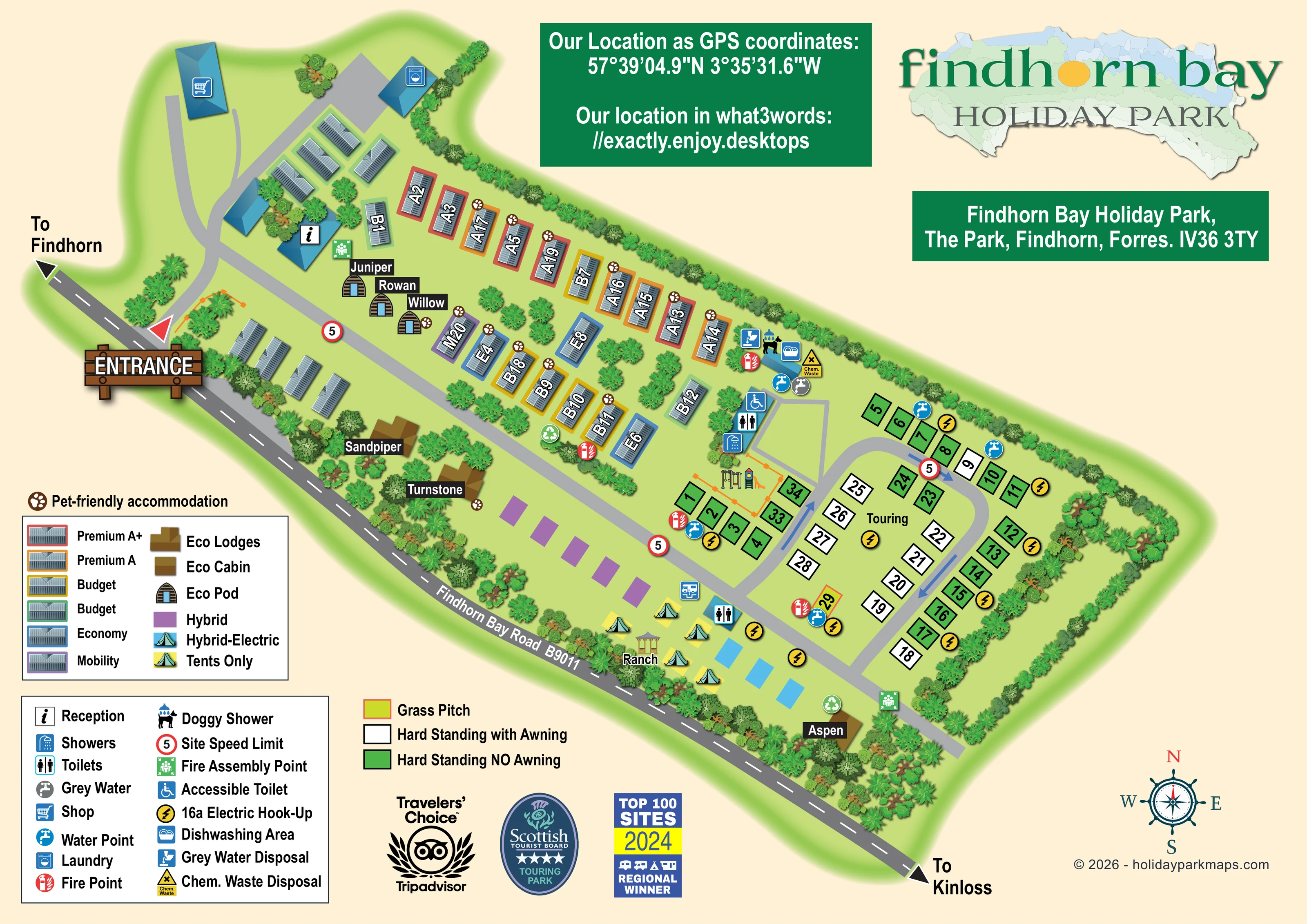
An information symbol marks a blue-roofed reception building close to the entrance junction.
A shopping trolley symbol identifies the separate blue-roofed shop at the upper-left end of the plan.
A washing-machine symbol marks a building beyond the caravan group near reception.
Toilet and shower symbols identify the main facilities beside the touring entrance, with another toilet building beside the camping strip.
A wheelchair symbol marks an accessible toilet at the main touring-side facilities cluster.
A dog beneath a shower symbol locates the dog-washing facility in the service cluster between the caravan rows and touring area.
A bowl-and-plates symbol marks a dishwashing area beside the dog shower and disposal facilities.
An information symbol marks a blue-roofed reception building close to the entrance junction.
A shopping trolley symbol identifies the separate blue-roofed shop at the upper-left end of the plan.
A washing-machine symbol marks a building beyond the caravan group near reception.
Toilet and shower symbols identify the main facilities beside the touring entrance, with another toilet building beside the camping strip.
A wheelchair symbol marks an accessible toilet at the main touring-side facilities cluster.
A dog beneath a shower symbol locates the dog-washing facility in the service cluster between the caravan rows and touring area.
A bowl-and-plates symbol marks a dishwashing area beside the dog shower and disposal facilities.
Blue tap symbols are distributed around the touring pitches and central service area.
Separate grey-water and disposal symbols appear in the touring-side service cluster.
A yellow warning-style symbol and Chem. Waste label identify the disposal point near the dog shower and dishwashing area.
A blue vehicle-over-drain symbol appears beside the camping-side toilet building. It is not separately explained in the visible key.
Yellow lightning-bolt circles identify electrical hook-up provision around the touring loop and Hybrid-Electric strip.
Swings and a slide are illustrated within an orange-fenced enclosure beside the touring pitches and main washroom block.
The label Ranch accompanies a small open-sided shelter in the tent camping area.
Green recycling symbols appear beside the caravan rows and near Aspen.
Repeated red extinguisher symbols mark fire points through the accommodation and touring sections.
Green assembly symbols are positioned near reception and at the far end of the main internal road.
Brown paw symbols distinguish selected caravans and named eco accommodation; they do not indicate a park-wide pet policy.
A large timber-style ENTRANCE sign identifies the junction between the B9011 and the internal park road.
The external road follows the diagonal lower edge of the site, with directions to Findhorn and Kinloss at opposite ends.
Blue arrows show circulation around the rounded touring loop, which connects to the long internal spine road.
Red-bordered circular signs bearing 5 are shown at intervals along the internal routes.
Dense mixed foliage defines the perimeter, separates caravan rows and encloses the eco accommodation and camping strip.
The park is near Findhorn on the Moray coast, with bay views forming part of the eco lodge setting. The site plan itself does not depict the bay or shoreline.
READING THE MAP
This illustrated map of Findhorn Bay Holiday Park brings several different styles of holiday accommodation into one coherent site plan. Set near Findhorn on Scotland's Moray coast, the park combines caravan accommodation, named eco lodges and pods, touring pitches and a smaller camping strip. The artwork makes those distinctions visible through coloured plot surrounds, individual building illustrations and a substantial accommodation key.
The site stretches diagonally along Findhorn Bay Road, with a prominent entrance at one end and a touring loop at the other. Reception, the shop and laundry establish the arrival area, while a cluster of washrooms, washing facilities and disposal points links the caravan and touring sections. Trees and shrubs give structure to the grounds without obscuring the roads or accommodation labels.
For a mapping client with a varied accommodation offer, this sample shows how a pictorial plan can retain practical detail. Named units, numbered pitches, pet-friendly markers and service symbols share the same page, supported by separate keys and clear external road directions. The coastal character comes through in the branding and compass rather than a scenic view of the bay.
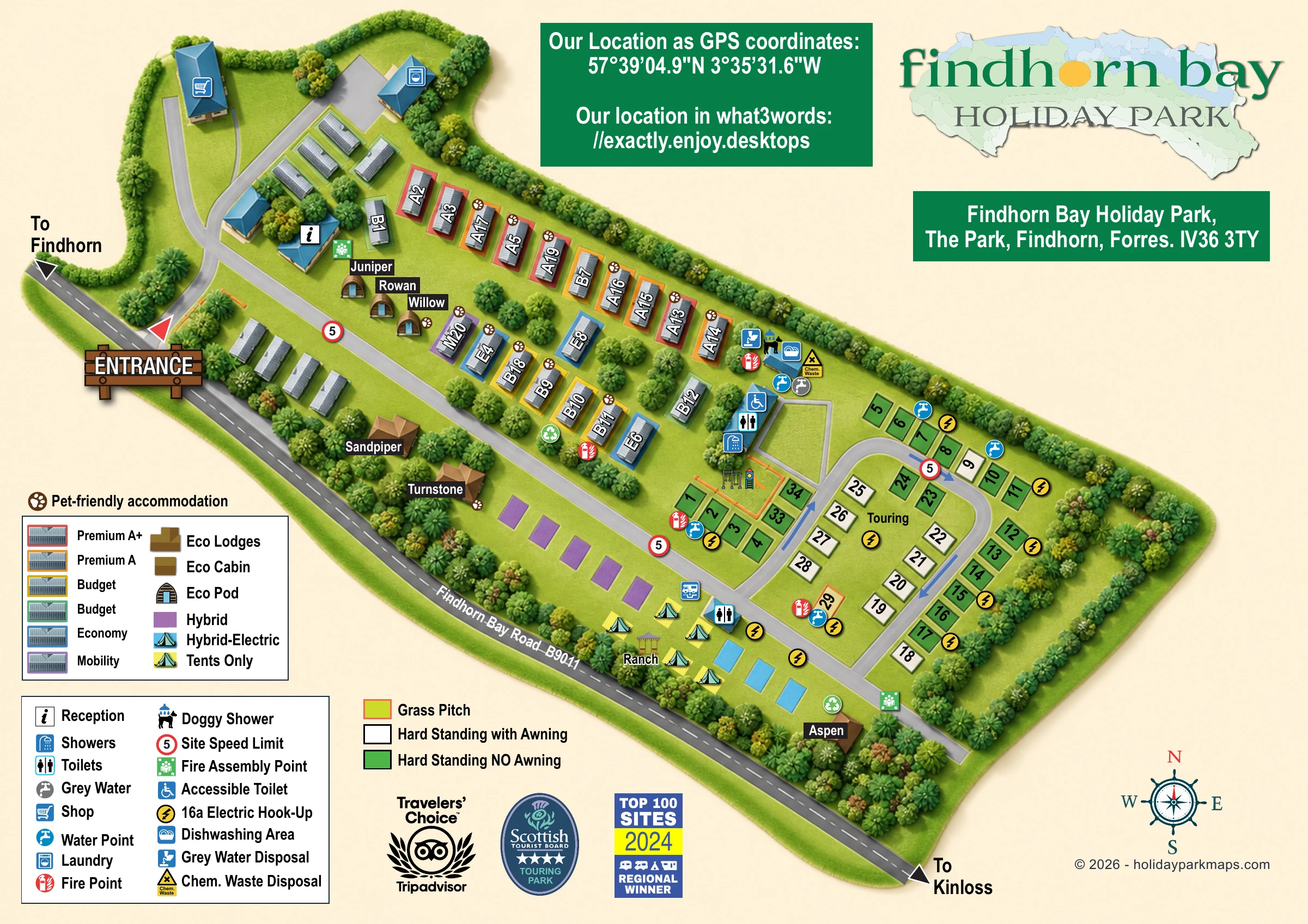
The single landscape-format artwork presents the whole site as a diagonal overhead plan. Findhorn Bay Road B9011 runs along the lower edge, with arrows towards Findhorn and Kinloss. A large illustrated entrance sign marks the access junction. Inside, a branching road leads to reception, the shop and laundry before becoming the main spine through the accommodation areas.
Grey-roofed caravans sit in planted rows, with coloured surrounds corresponding to Premium A+, Premium A, Budget, Economy and Mobility entries in the key. Selected units carry brown paw markers. Juniper, Rowan and Willow are illustrated as arched eco pods near reception. Sandpiper and Turnstone use brown lodge forms along the roadside planting, while Aspen appears near the far end of the accommodation strip. Purple Hybrid rectangles, blue Hybrid-Electric rectangles and a Tents Only area complete this side of the plan. A small shelter is labelled Ranch.
The touring area occupies the opposite end of the park. Numbered green and white pitch rectangles wrap around a rounded road loop, with a separate grass-pitch colour in the key. Blue arrows indicate circulation. Yellow electric hook-up symbols and blue water taps punctuate the pitch groups. An orange-fenced play area, illustrated with swings and a slide, sits beside the main toilet and shower facilities.
Nearby symbols locate an accessible toilet, dog shower, dishwashing area, grey-water facilities and chemical waste disposal. Further toilet, recycling, fire-point and assembly symbols are distributed across the plan. Large legends occupy the lower-left page margin, while branding, address and location panels fill the upper space. Award badges and a nautical compass complete the composition. The detail views enlarge overlapping portions of this same artwork, rather than presenting additional park sections.
 Enlarge this map ↗
KEEP EXPLORING
Chosen for shared landscapes, accommodation or facilities.
 Explore the map ↗
United Kingdom
A colour-zoned coastal park map with touring areas, woodland trails, ponds and a leisure club.
 Explore the map ↗
United Kingdom
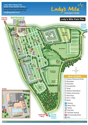
Portrait park plan with named fields, numbered accommodation, beach directions and an enlarged leisure-complex inset.
 Explore the map ↗
United Kingdom
Trevornick’s colour-coded park map, with mixed accommodation, fishing ponds, golf and wooded trails.
Features may come from the sample artwork, its key or published park information. Approximate numbers describe the drawing and may cover only part of a park. They are intended to help you compare map examples. Current facilities and booking information should be checked with the park.
LET’S MAP YOUR PARK
For a map quotation, find your park and draw a rough boundary around it. The area you select helps us work out the design time and price.
Draw your park for a quote ↗Or talk to our map designers
01751 473136