
Railway line
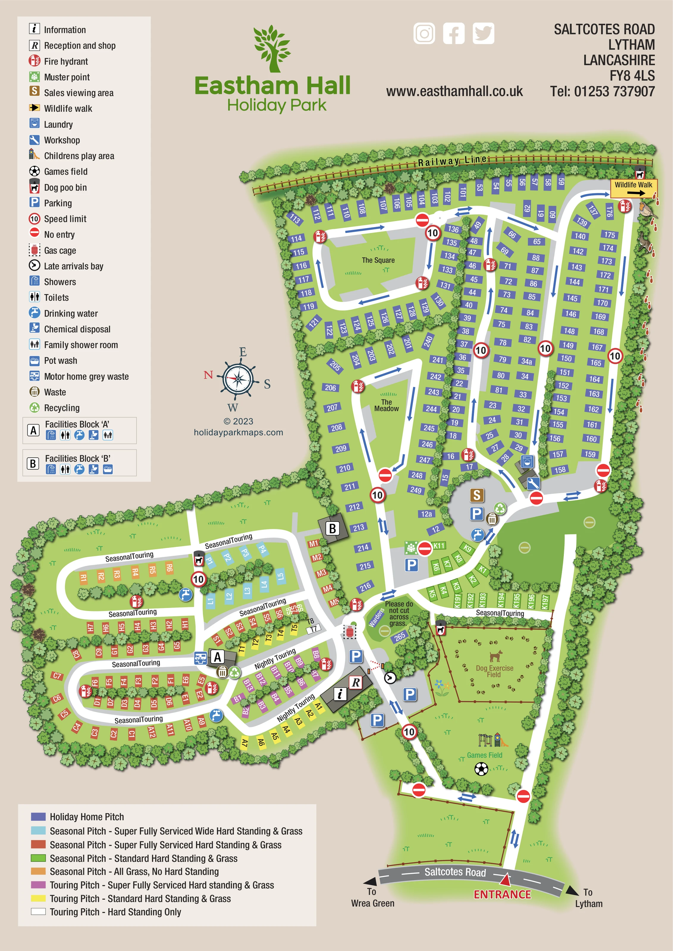
A labelled railway with illustrated sleepers and rails runs across the upper boundary behind a dense belt of trees.
ILLUSTRATED PARK MAP · P107
Saltcotes Road, Lytham, Lancashire · United Kingdom
 Enlarge the map ↗
A SENSE OF THE PLACE
Eastham Hall Holiday Park is based at Saltcotes Road, Lytham, Lancashire. Eastham Hall's website identifies the park as being in Lytham. The park provides nightly touring and seasonal touring stays.
Standard touring pitches are described as gravel hardstanding with a grass area and 16A electric supply.
LOOK CLOSER
A labelled railway with illustrated sleepers and rails runs across the upper boundary behind a dense belt of trees.
Dense trees enclose the park and divide accommodation groups. Open grass centres named The Square and The Meadow provide landmarks within the holiday-home area.
A grey building beside the arrival lane carries reception/shop and information symbols, with parking close by.
The full plan locates both lettered blocks. Their keyed services include showers, toilets, drinking water and chemical disposal; block A additionally lists a family shower room, while block B lists pot wash. The section variant locates B but retains both blocks in its key.
A laundry symbol identifies a small building near the lower end of the holiday-home lanes.
A workshop building is marked immediately beside the laundry and central road junction.
A brown S symbol marks a grey surfaced area between the holiday-home lanes and seasonal pitches, accompanied by parking and service symbols.
Illustrated swings, a climbing tower and slide identify the play area within the Games Field near the arrival routes.
A grey building beside the arrival lane carries reception/shop and information symbols, with parking close by.
The full plan locates both lettered blocks. Their keyed services include showers, toilets, drinking water and chemical disposal; block A additionally lists a family shower room, while block B lists pot wash. The section variant locates B but retains both blocks in its key.
A laundry symbol identifies a small building near the lower end of the holiday-home lanes.
A workshop building is marked immediately beside the laundry and central road junction.
A brown S symbol marks a grey surfaced area between the holiday-home lanes and seasonal pitches, accompanied by parking and service symbols.
Illustrated swings, a climbing tower and slide identify the play area within the Games Field near the arrival routes.
A labelled grass recreation area, reinforced by a football symbol, sits below the dog exercise field.
A fenced grass enclosure is labelled for dog exercise and illustrated with a dog and a circuit of paw prints.
Dog waste-bin symbols occur beside the dog field, within the touring area and at the wildlife-walk end of the park.
A yellow direction panel at the upper-right corner introduces a boundary walk illustrated with footprints, a bird and a rabbit.
Blue P symbols identify several surfaced parking areas near reception, the sales viewing area and the central junction.
The late-arrivals symbol is positioned beside the barrier on the reception approach.
Tap symbols mark water points in the touring areas and near the sales viewing area; water is also included in the facilities-block key.
A motorhome waste symbol is located beside facilities block A on the complete plan.
Paired waste and recycling symbols appear near block A and at the sales viewing area.
A cylinder within a dashed enclosure marks the gas cage near the wardens' area and central arrival junction.
A labelled wardens' pitch or area sits on a landscaped island near reception and the touring junction.
Repeated red fire-hydrant symbols are distributed along the lanes, and a green muster-point symbol appears near the central parking area.
A labelled railway with illustrated sleepers and rails runs across the upper boundary behind a dense belt of trees.
Dense trees enclose the park and divide accommodation groups. Open grass centres named The Square and The Meadow provide landmarks within the holiday-home area.
The full plan connects the park entrance to Saltcotes Road, with directions towards Wrea Green and Lytham. The section variant instead labels separate entrance and exit routes at its lower edge.
Blue arrows distinguish one-way and two-way movement. Red no-entry symbols, circular 10 speed-limit signs and an illustrated reception barrier support the mapped circulation pattern.
READING THE MAP
This map of Eastham Hall Holiday Park in Lytham, Lancashire, brings holiday-home pitches, seasonal touring and nightly touring together in one colour-coded plan. A companion holiday-home-section version uses the same artwork to give greater prominence to the upper part of the park and its arrival routes.
The setting is expressed through dense tree belts, open grass areas and a railway line along the upper boundary. Within that framework, white roads and blue directional arrows lead through numbered pitch rows, around The Square and The Meadow, and towards reception and the touring facilities. Purple identifies the holiday-home pitches, while a broader palette separates touring pitches by use, surface and servicing.
The map also gives space to everyday visitor destinations: reception and shop, facilities blocks, laundry, parking, a sales viewing area and disposal points. More pictorial touches distinguish the recreation spaces, including play equipment in the Games Field, paw prints in the Dog Exercise Field and wildlife beside the boundary walk. It is a useful sample for parks needing detailed pitch-level navigation without turning the whole page into a technical site drawing.
The complete portrait map places Eastham Hall's green tree logo above a tree-enclosed plan, with a tall facilities key on the left and a separate pitch-colour key below. Saltcotes Road anchors the bottom edge, accompanied by directions towards Wrea Green and Lytham. From the entrance, the internal routes connect with reception, nearby parking and the central junction before branching into accommodation lanes.
The upper area is predominantly purple holiday-home pitches. On its left, roads encircle the open greens labelled The Square and The Meadow; towards the right, long lanes serve paired rows of pitches. Trees separate these groups and form a substantial boundary beneath the illustrated railway. A yellow Wildlife Walk panel at the upper-right corner introduces a line of footprints and small animal illustrations along the park edge.
Below the holiday homes, rounded touring loops use several contrasting colours. The full key distinguishes seasonal and nightly touring, wider pitches, grass-only pitches and different hardstanding and servicing combinations. Facilities blocks A and B are lettered directly on grey building footprints, with their services explained in the key. Laundry, workshop, sales viewing, drinking water, waste and recycling points are marked individually. Reception is accompanied by information, parking, a barrier and a late-arrivals symbol.
The lower recreation area contains the fenced Dog Exercise Field and the Games Field with illustrated play equipment. Blue movement arrows, red no-entry symbols and speed-limit signs make circulation a prominent part of the design.
The holiday-home-section version removes the lower-left touring loops and external road context, enlarges the retained plan and labels entrance and exit separately. Its reduced three-colour pitch key and repositioned facility legend create a more focused companion page without introducing another site.
KEEP EXPLORING
Chosen for shared landscapes, accommodation or facilities.
 Explore the map ↗
United Kingdom
Woodland-framed Barnsoul map with mixed accommodation, shared facilities and paw-marked walking routes.
 Explore the map ↗
United Kingdom
Coastal park plan with colour-coded pitches, named neighbourhoods and a Morecambe Bay walking route.
 Explore the map ↗
United Kingdom
Colour-coded touring-park plan for Black Bull, with numbered pitches, a paw-print dog walk, service icons and entrance recreation areas, paired with a visitor-information reverse.
Features may come from the sample artwork, its key or published park information. Approximate numbers describe the drawing and may cover only part of a park. They are intended to help you compare map examples. Current facilities and booking information should be checked with the park.
LET’S MAP YOUR PARK
For a map quotation, find your park and draw a rough boundary around it. The area you select helps us work out the design time and price.
Draw your park for a quote ↗Or talk to our map designers
01751 473136