
Wildlife pond
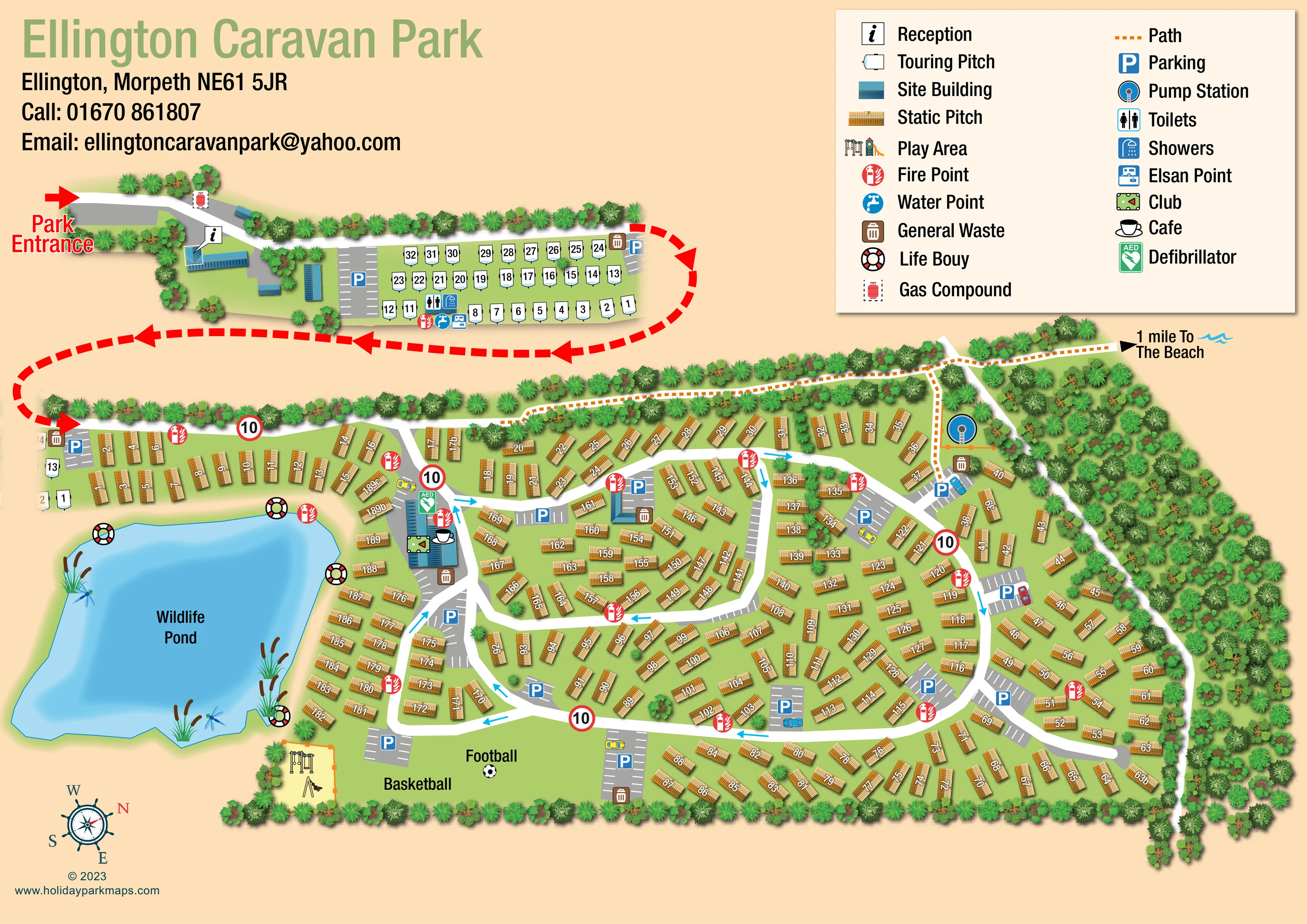
A large irregular blue pond dominates the left side of the main park, illustrated with reeds and dragonflies.
ILLUSTRATED PARK MAP · P110
Ellington Caravan Park, Ellington, Morpeth · United Kingdom
 Enlarge the map ↗
A SENSE OF THE PLACE
Ellington Caravan Park is a family-run holiday home park near the Northumberland coast. Fields and woodland surround its static caravan and seasonal touring areas.
The park focuses on owners and seasonal visitors, with Ellington village and Cresswell Beach nearby. Social entertainment forms part of the park's offering, while the surrounding countryside and coastline provide space for walking and time outdoors.
LOOK CLOSER
A large irregular blue pond dominates the left side of the main park, illustrated with reeds and dragonflies.
Dense overlapping tree crowns enclose much of the park, with a broad wooded strip along the right side and smaller planting groups between pitches.
An information-symbol callout identifies a blue-roofed building immediately inside the entrance.
A club symbol marks the larger blue-roofed building beside the wildlife pond and the main internal junction.
A cup-and-saucer symbol identifies the café at the pond-side club building.
An orange-edged pale-yellow play space with illustrated equipment sits below the pond, beside the sports lawn.
Football and basketball labels identify an open green recreation area along the lower edge of the main park.
A grouped set of service symbols sits along the lower edge of the touring rows near reception.
An information-symbol callout identifies a blue-roofed building immediately inside the entrance.
A club symbol marks the larger blue-roofed building beside the wildlife pond and the main internal junction.
A cup-and-saucer symbol identifies the café at the pond-side club building.
An orange-edged pale-yellow play space with illustrated equipment sits below the pond, beside the sports lawn.
Football and basketball labels identify an open green recreation area along the lower edge of the main park.
A grouped set of service symbols sits along the lower edge of the touring rows near reception.
Grey bays with white stall markings and blue P symbols are distributed beside reception, touring pitches, social facilities and accommodation roads.
Brown bin symbols mark several waste locations, generally beside buildings or parking areas.
Red circular fire symbols recur throughout the accommodation areas and near the pond.
A green AED symbol is positioned at the club and café building.
Lifebuoy symbols are placed around the perimeter of the wildlife pond.
A red gas-cylinder symbol within a dashed enclosure is shown beside the entrance approach.
A large blue pump-station symbol appears within an orange-edged enclosure near the upper-right woodland and footpath.
Blue-roofed structures distinguish site buildings from the gold static pitches; some have no more specific functional label.
A large irregular blue pond dominates the left side of the main park, illustrated with reeds and dragonflies.
Dense overlapping tree crowns enclose much of the park, with a broad wooded strip along the right side and smaller planting groups between pitches.
A prominent red arrow marks the upper-left entrance. A bold dashed red arrowed line connects the separately spaced entrance and touring section with the main accommodation plan.
White curving roads form connected loops and branches through the static pitches. Cyan arrows indicate travel direction, while red-bordered signs display 10.
An orange dotted path follows the upper boundary and branches through the wooded side of the park. An outward arrow is labelled '1 mile To The Beach'; the beach itself is not depicted.
READING THE MAP
This illustrated map of Ellington Caravan Park brings together a substantial static-caravan layout, a compact touring area and a distinctive wildlife pond. Set in Ellington near Morpeth, Northumberland, the park is presented as a green, tree-framed site with a pedestrian route pointing towards the nearby coast. Gold accommodation symbols, blue-roofed buildings and white internal roads give each part of the plan a clear visual role.
The composition separates the entrance and reception area from the larger main park, using a bold red dashed connection to carry the reader between them. Within the main plan, curved roads pass through numbered caravan groups, with small parking bays and facility symbols positioned at useful junctions. The pond-side club and café, children's play area, and football and basketball lawn provide landmarks beyond the individual pitches.
A large two-column key explains the accommodation, services and safety symbols without crowding the site itself. This sample is particularly relevant to parks that need to combine detailed pitch finding with an approachable picture of their landscape, social spaces and walking connections.
The landscape-format artwork places the park name and contact block at the upper left and a large cream legend at the upper right. Below the heading, the entrance leads past reception and several blue-roofed site buildings to a compact touring area. White caravan-shaped pitch symbols sit in regular rows beside parking, with toilets, showers, a water point and an Elsan point grouped along their lower edge. A heavy red dashed arrowed line connects this upper section visually with the main park below.
Most of the main plan comprises gold static-pitch illustrations arranged around broad white roads. The units turn with the layout, forming short rows, angled clusters and curved bands along the boundaries. Small grey parking bays are distributed between these groups. Cyan arrows show directions on the internal roads, and red-bordered signs display 10. Repeated fire and waste symbols remain distinct from the pitch numbering.
The large wildlife pond anchors the left side of the composition. Layered blue water, reeds and dragonflies distinguish it from the more densely developed ground, while lifebuoy symbols mark its edges. The club and café occupy a blue-roofed building beside the pond, with a green AED symbol nearby. Below, an illustrated play area adjoins the open lawn labelled for football and basketball.
Dense tree crowns frame the lower and right boundaries. An orange dotted path runs along the upper edge and branches beside the pump station into the wooded side of the site, ending towards a beach direction label. A rotated nautical-style compass completes the page. The enlarged views show details of this same single plan, rather than additional sections or accommodation.
KEEP EXPLORING
Chosen for shared landscapes, accommodation or facilities.
 Explore the map ↗
United Kingdom
A colour-zoned coastal park map with touring areas, woodland trails, ponds and a leisure club.
 Explore the map ↗
United Kingdom
Trevornick’s colour-coded park map, with mixed accommodation, fishing ponds, golf and wooded trails.
 Explore the map ↗
United Kingdom
Illustrated Anglesey holiday-park map with numbered homes, family facilities and a footprint-marked coastal path.
Features may come from the sample artwork, its key or published park information. Approximate numbers describe the drawing and may cover only part of a park. They are intended to help you compare map examples. Current facilities and booking information should be checked with the park.
LET’S MAP YOUR PARK
For a map quotation, find your park and draw a rough boundary around it. The area you select helps us work out the design time and price.
Draw your park for a quote ↗Or talk to our map designers
01751 473136