
Walled Garden
A named garden beside the entrance-side buildings and parking, above Headland Rise.
ILLUSTRATED PARK MAP · P297
Silver Bay Holiday Park, Rhoscolyn, Pentre Gwddel, Anglesey · United Kingdom
 Enlarge the map ↗
A SENSE OF THE PLACE
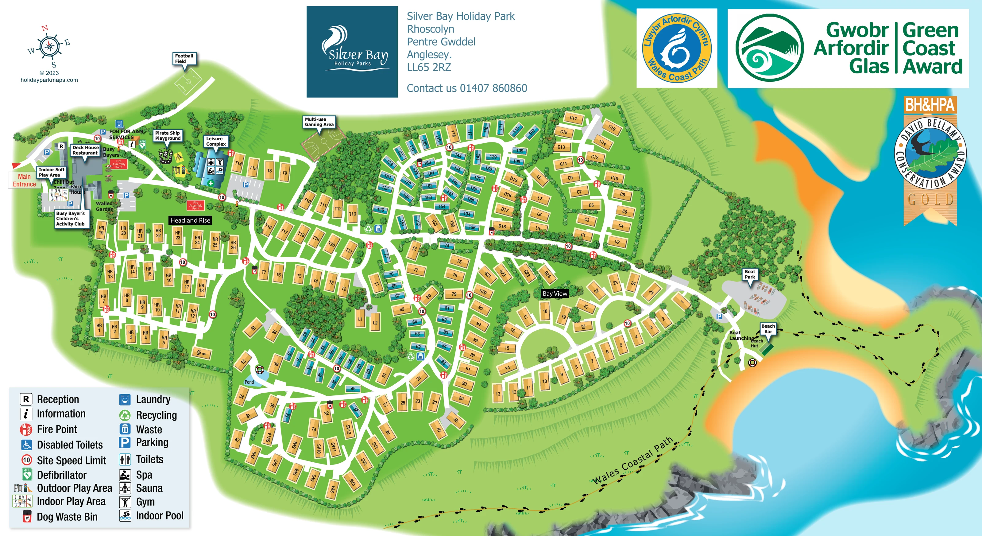
Silver Bay is a private holiday home park at Rhoscolyn on Anglesey. Lodges and modern caravans are set behind the dunes, with a private path leading to the beach.
An indoor pool, spa facilities, gym and places to eat provide leisure options on site. The map shows how the holiday home areas connect with shared facilities and the coastal access route.
LOOK CLOSER
A named garden beside the entrance-side buildings and parking, above Headland Rise.
A small blue pond is labelled within the lower-central accommodation area and illustrated with a lifebuoy.
Golden beaches, grey rock outcrops, white surf and turquoise water occupy the right and lower edges of the artwork.
Dense tree groups and hedges divide accommodation neighbourhoods; repeated triangular slope marks describe the coastal landform.
Reception is marked within the entrance-side building group, with an information symbol nearby.
Named restaurant in the main entrance-side hub, illustrated with a substantial grey-roofed building and nearby picnic tables.
A blue-roofed leisure building beside the main internal route and a marked parking area.
The swimming symbol is placed on the Leisure Complex and identified as an indoor pool in the legend.
Reception is marked within the entrance-side building group, with an information symbol nearby.
Named restaurant in the main entrance-side hub, illustrated with a substantial grey-roofed building and nearby picnic tables.
A blue-roofed leisure building beside the main internal route and a marked parking area.
The swimming symbol is placed on the Leisure Complex and identified as an indoor pool in the legend.
Three distinct leisure symbols on the Leisure Complex identify spa, gym and sauna facilities.
Labelled within the entrance-side family facilities cluster, accompanied by an indoor-play illustration.
Named children's activity club beside the entrance-side buildings; Busy Bayers is also labelled near the outdoor tables.
A named zone within the main building and family-activity hub.
A named building adjoining the entrance-side complex; its operational use is not specified.
A prominently illustrated black pirate ship, slide and play equipment between the restaurant hub and Leisure Complex.
A football pitch occupies the upper-left extension of the grounds; a separate marked multi-use court sits beside woodland near the upper centre.
A named garden beside the entrance-side buildings and parking, above Headland Rise.
A small blue pond is labelled within the lower-central accommodation area and illustrated with a lifebuoy.
A grey boat-storage area containing small boat illustrations lies at the coastal end of the main internal route.
A named boat-launching connection leads from the boat-park area towards the beach.
Beach Bar and Beach Hut labels identify a small green-roofed coastal building beside the beach approach.
Golden beaches, grey rock outcrops, white surf and turquoise water occupy the right and lower edges of the artwork.
Dense tree groups and hedges divide accommodation neighbourhoods; repeated triangular slope marks describe the coastal landform.
A named coastal route follows the lower park edge and headland, drawn as a fine brown line with repeated black footprints.
The main entrance is flagged at the left edge. White lanes connect the arrival hub, accommodation groups and beach approach, with grey parking and surfaced areas.
Blue parking symbols mark several entrance-side spaces, the Leisure Complex car park and a coastal parking area near the Boat Park.
Laundry and toilets, including a wheelchair-marked toilet symbol, are mapped around the entrance-side facilities.
Paired waste and recycling symbols appear within the accommodation areas; dog-waste bins are marked at several route-side locations.
Repeated red fire-point symbols line the accommodation lanes. Two red assembly-point labels appear near the main hub, and a green AED symbol is placed beside the information point.
Circular red-bordered markers displaying 10 are repeated along the internal routes.
READING THE MAP
This illustrated map of Silver Bay Holiday Park brings together a sizeable holiday-home layout and its coastal setting at Rhoscolyn on Anglesey. Numbered accommodation blocks sit within green, hedge-lined neighbourhoods, while sandy bays, rocky headlands and turquoise water give the shoreline a prominent place in the composition. The Wales Coastal Path is drawn with a distinctive trail of footprints around the outer edge of the park.
The map connects practical visitor information with recognisable landmarks. At the main entrance, reception, the Deck House Restaurant and children's activities form a compact arrival hub. Nearby, the Leisure Complex, pirate ship playground, football field and multi-use court are individually identified. Further across the site, Bay View leads towards the Boat Park, boat-launching area and beach-side facilities.
For a holiday-home park with several accommodation neighbourhoods, this approach makes both the internal routes and the wider visitor experience visible on one page. A clear symbol key supports the individual labels, while detailed planting and coastal illustration distinguish this sample from a purely diagrammatic site plan.
The single landscape-format artwork places the main entrance at the left edge, beside reception and a closely grouped collection of shared buildings. Pointer labels identify the Deck House Restaurant, Indoor Soft Play Area, Busy Bayer’s Children’s Activity Club, Chill Out Zone, Farm House and Walled Garden. Picnic tables and small play illustrations add detail to this busy arrival area.
A broad white internal route passes the Pirate Ship Playground and blue-roofed Leisure Complex before continuing through the accommodation towards the coast. Pool, spa, gym and sauna pictograms sit directly on the leisure building, with a grey parking area alongside. A football field extends into the upper-left grounds, and a separately labelled multi-use gaming area lies beside a central woodland block.
Accommodation is represented by numbered gold and blue rectangles with pale outlines and shaded roof strips. Headland Rise occupies a compact grid of short lanes at lower left; the central areas use branching routes and curved rows around trees and a small pond. Bay View is organised around rounded loops close to the beach approach. Hedges and dense tree groups separate these neighbourhoods without obscuring their connections.
At the coastal end, boats are illustrated within the Boat Park, and labels mark boat launching, the Beach Bar and Beach Hut. Beyond them, golden sand, rocky projections and white surf frame the water. The Wales Coastal Path follows a fine brown line punctuated by black footprints around the grassy coastal margin.
A two-column legend explains visitor facilities and safety symbols, including parking, laundry, toilets, recycling, fire points and the defibrillator. Branding and coastal award graphics occupy the upper page, balanced by a nautical compass at left. The enlarged detail views reproduce portions of this same plan rather than adding another map variant.
KEEP EXPLORING
Chosen for shared landscapes, accommodation or facilities.
 Explore the map ↗
United Kingdom
A colour-zoned coastal park map with touring areas, woodland trails, ponds and a leisure club.
 Explore the map ↗
United Kingdom
Trevornick’s colour-coded park map, with mixed accommodation, fishing ponds, golf and wooded trails.
 Explore the map ↗
United Kingdom
Colour-coded accommodation, central leisure facilities and coastal paths on an illustrated headland park map.
Features may come from the sample artwork, its key or published park information. Approximate numbers describe the drawing and may cover only part of a park. They are intended to help you compare map examples. Current facilities and booking information should be checked with the park.
LET’S MAP YOUR PARK
For a map quotation, find your park and draw a rough boundary around it. The area you select helps us work out the design time and price.
Draw your park for a quote ↗Or talk to our map designers
01751 473136