
Five Acre Field
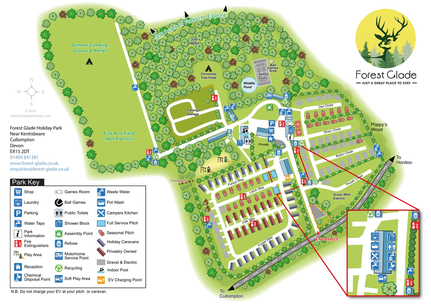
A large western clearing is labelled Five Acre Field (Non-Electric), without individual camping plots.
ILLUSTRATED PARK MAP · P125
Forest Glade Holiday Park, Near Kentisbeare, Cullompton, Devon · United Kingdom
 Enlarge the map ↗
A SENSE OF THE PLACE
Forest Glade Holiday Park occupies a clearing in the Blackdown Hills between Cullompton and Honiton. The family-run Devon park offers holiday caravans, camping pods, an apartment and touring and camping pitches.
Sheltered fields and surrounding pine woodland give the site its character. Pitch areas are arranged in distinct sections, and the map helps visitors compare these settings and locate shared facilities.
LOOK CLOSER
A large western clearing is labelled Five Acre Field (Non-Electric), without individual camping plots.
The upper-left field is explicitly labelled for summer camping, groups and rallies.
Christmas Tree Field is labelled within a clearing above caravan storage.
Dense illustrated woodland surrounds and divides the park, with Tom's Wood labelled above the central clearings and Poppy's Wood along the eastern edge.
A blue pond labelled Wildlife Pond lies immediately west of the tennis court.
A smaller labelled duck pond sits beside the central recreation and service buildings.
The upper woodland margin carries the wording '300 Acres of Forest to Explore'; this refers to the forest setting rather than a stated park footprint.
Reception is marked among the central buildings, close to the main internal junction.
Reception is marked among the central buildings, close to the main internal junction.
Shop, visitor parking and park information symbols are grouped around the central facilities hub.
An indoor swimming pool symbol identifies a building just west of the central hub.
Games room and soft play symbols appear near the duck pond and central buildings. The soft play symbol uses a vehicle motif in this artwork.
Two illustrated play-equipment clusters occupy tree-lined clearings beside the lower accommodation area.
A grey court with white line markings is labelled Tennis Court in the upper woodland clearing.
A labelled ball games area lies beside the tennis court.
Public toilets and shower facilities are marked at the central hub and at the block enlarged in the inset.
The enlarged amenities-block inset identifies laundry, pot wash and campers' kitchen facilities.
Water taps and waste-water points are distributed around the accommodation and camping areas, with chemical disposal also identified at the amenities block.
Blue motorhome service symbols appear beside the upper approach to the central hub and in the amenities-block inset.
An orange EV charging symbol is shown beside a building on the eastern side of the lower facilities area.
Refuse and recycling symbols recur at shared service locations around the park.
Red fire-extinguisher markers are distributed around the site, and a green assembly-point symbol appears north of the central hub.
A labelled caravan storage area has a separate looped access to the west of the facilities hub.
A large western clearing is labelled Five Acre Field (Non-Electric), without individual camping plots.
The upper-left field is explicitly labelled for summer camping, groups and rallies.
Christmas Tree Field is labelled within a clearing above caravan storage.
Dense illustrated woodland surrounds and divides the park, with Tom's Wood labelled above the central clearings and Poppy's Wood along the eastern edge.
A blue pond labelled Wildlife Pond lies immediately west of the tennis court.
A smaller labelled duck pond sits beside the central recreation and service buildings.
The entrance branches from the diagonal boundary road, which carries direction arrows towards Cullompton and Honiton.
Forest Way, Larch Way and Oak Way organise the lower accommodation area; Owl Close, Wren Close, Robin Close and Thrush Close identify the right-hand sections.
A footpath is labelled along the wooded western side of the lower accommodation area.
The upper woodland margin carries the wording '300 Acres of Forest to Explore'; this refers to the forest setting rather than a stated park footprint.
READING THE MAP
Forest Glade's map presents a holiday park organised around sheltered clearings in Devon's Blackdown Hills. Woodland is not simply a background here: dense clusters of illustrated trees separate the camping fields, frame the caravan rows and give the different parts of the park their own identity.
The plan brings together holiday caravans, privately owned units, seasonal pitches, serviced touring spaces and broad camping areas. Named roads make the more structured sections easy to follow, while labels such as Five Acre Field, Christmas Tree Field and Summer Camping, Groups & Rallies explain the larger open spaces. The entrance connects to a central facilities hub, with recreation extending north towards the ponds and tennis court.
A substantial symbol key supports the map's practical role, identifying everything from reception and the indoor pool to water taps, recycling and motorhome servicing. A red-framed detail inset makes the busy amenities block readable without sacrificing the overall woodland layout. With its deer emblem, fresh greens and clear colour coding, this sample shows how an illustrated park map can communicate both a distinctive setting and a varied accommodation offer.
The plan is arranged around a central junction, with the entrance on the diagonal road along the lower-right edge. Direction arrows identify the road towards Cullompton and Honiton. White internal roads branch into the lower caravan area, the right-hand touring sections and the larger camping fields to the left.
Forest Way follows the lower accommodation area's perimeter, while Larch Way and Oak Way divide its internal rows. Slate-purple holiday caravans, red privately owned units, salmon seasonal caravans, grey gravel-and-electric pitches and cyan full-service pitches are differentiated by the key. Owl Close, Wren Close, Robin Close and Thrush Close organise the right-hand section, with an open grass-with-electric area below. Two small arched pod illustrations sit beside the western edge of the lower accommodation area.
The central buildings carry symbols for reception, shop, parking, park information, indoor pool, games room, soft play, toilets and showers. A separate block nearer the entrance is enlarged in a red-bordered inset, showing laundry, washing-up, campers' kitchen and waste-water facilities alongside toilets, showers and chemical disposal. Water taps, refuse, recycling and fire-extinguisher symbols recur around the park. Motorhome servicing and an orange EV charging marker are also shown.
Above the hub are a duck pond, wildlife pond, tennis court and ball games area. Two illustrated playgrounds occupy woodland margins to the west. Caravan storage has its own looped access, while Five Acre Field is labelled non-electric and the upper-left field is designated for summer camping, groups and rallies.
Dense outlined tree symbols frame these clearings and identify Tom's Wood and Poppy's Wood. A compass, large lower-left key, contact block and upper-right deer-and-forest branding complete the page.
KEEP EXPLORING
Chosen for shared landscapes, accommodation or facilities.
 Explore the map ↗
United Kingdom
A colour-zoned coastal park map with touring areas, woodland trails, ponds and a leisure club.
 Explore the map ↗
United Kingdom
Trevornick’s colour-coded park map, with mixed accommodation, fishing ponds, golf and wooded trails.
 Explore the map ↗
United Kingdom
Woodland-framed Barnsoul map with mixed accommodation, shared facilities and paw-marked walking routes.
Features may come from the sample artwork, its key or published park information. Approximate numbers describe the drawing and may cover only part of a park. They are intended to help you compare map examples. Current facilities and booking information should be checked with the park.
TAKE A CLOSER LOOK
View the illustrated map in detail or choose a file to download. These are sample maps; contact the park for current visitor information.


LET’S MAP YOUR PARK
For a map quotation, find your park and draw a rough boundary around it. The area you select helps us work out the design time and price.
Draw your park for a quote ↗Or talk to our map designers
01751 473136