
Elongated water features and islands
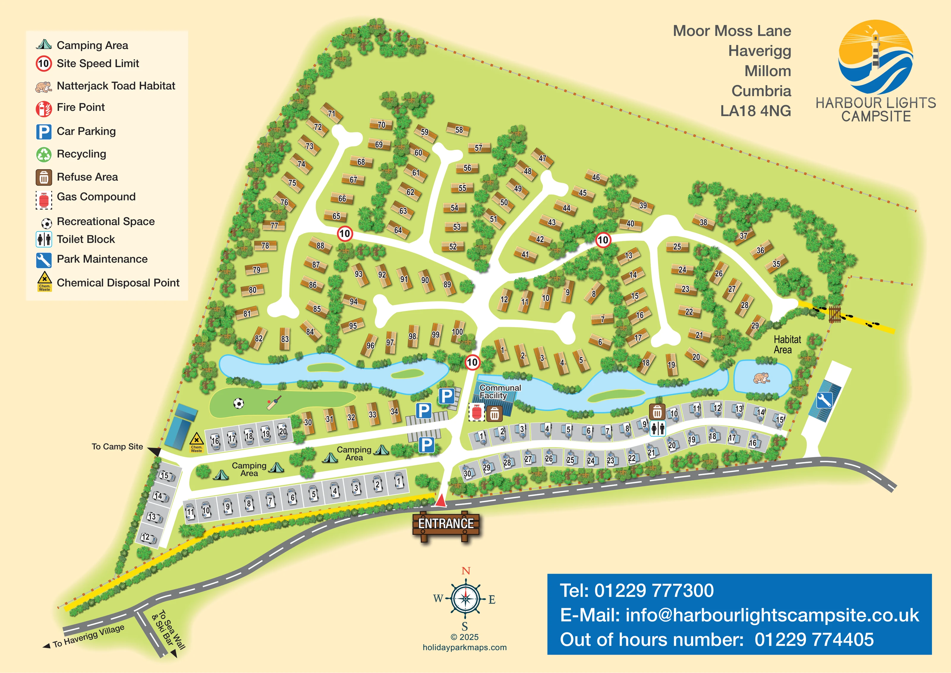
Pale-blue, irregular water features with small green islands form a landscaped corridor between the northern accommodation and the southern touring and camping areas.
ILLUSTRATED PARK MAP · P153
Moor Moss Lane, Haverigg, Millom, Cumbria · United Kingdom
 Enlarge the map ↗
A SENSE OF THE PLACE
Harbour Lights Campsite is located at Haverigg near the coast and the western Lake District. Grass and hardstanding touring pitches are available, with electric options.
Published visitor information describes heated washrooms, a café and ice-cream parlour, plus a dog-washing station. The nearby lagoon and coast provide further recreation; water-sports attractions there are separate from the campsite's own facilities.
LOOK CLOSER
Pale-blue, irregular water features with small green islands form a landscaped corridor between the northern accommodation and the southern touring and camping areas.
The eastern 'Habitat Area' includes a small pond carrying the toad symbol identified in the legend as Natterjack Toad Habitat.
Dense illustrated trees and shrubs line boundaries, divide accommodation groups and edge the water features.
A timber-style ENTRANCE sign and red triangular marker identify arrival from the road along the southern boundary.
White lanes lead from the entrance into the touring rows and across the water-feature corridor, then branch into loops and rounded dead ends amongst the northern units.
Arrows at the south-western road junction indicate destinations outside the depicted campsite. The Ski Bar is a directional reference, not a mapped on-site facility.
A 'To Camp Site' arrow points west from the lane beside the chemical disposal point; the onward destination is not illustrated.
A yellow strip follows part of the southern boundary. Another yellow route, marked with footprints, passes through a drawn gate on the eastern edge.
A timber-style ENTRANCE sign and red triangular marker identify arrival from the road along the southern boundary.
White lanes lead from the entrance into the touring rows and across the water-feature corridor, then branch into loops and rounded dead ends amongst the northern units.
Arrows at the south-western road junction indicate destinations outside the depicted campsite. The Ski Bar is a directional reference, not a mapped on-site facility.
A 'To Camp Site' arrow points west from the lane beside the chemical disposal point; the onward destination is not illustrated.
A yellow strip follows part of the southern boundary. Another yellow route, marked with footprints, passes through a drawn gate on the eastern edge.
Pale-blue, irregular water features with small green islands form a landscaped corridor between the northern accommodation and the southern touring and camping areas.
The eastern 'Habitat Area' includes a small pond carrying the toad symbol identified in the legend as Natterjack Toad Habitat.
Dense illustrated trees and shrubs line boundaries, divide accommodation groups and edge the water features.
A green oval west of the central entrance lane is illustrated with a football and cricket equipment, indicating informal recreation rather than separately labelled sports pitches.
A blue-roofed building beside the central lane and water feature is explicitly labelled 'Communal Facility'; its specific activities are not stated.
A toilet symbol locates the facility amongst the eastern touring rows.
Several blue parking symbols identify small banks of spaces around the central junction, beside the communal facility and camping areas.
A yellow chemical-waste symbol marks the western service area beside the motorhome pitches and blue-roofed buildings.
Brown bin symbols mark disposal locations beside the communal building and within the eastern touring section.
A red cylinder within a dashed enclosure marks the gas compound beside the communal facility.
A blue spanner symbol identifies the maintenance building at the eastern edge, reached by a separate lane from the boundary road.
Repeated red-ringed '10' signs appear on internal lanes. They reproduce the artwork's speed-limit notation rather than establish a current operating rule.
The legend includes a red fire-point symbol, but no corresponding position is clearly identifiable in the plan.
Recycling is included in the legend; a separate mapped recycling location is not clearly identifiable.
READING THE MAP
This illustrated map of Harbour Lights Campsite at Haverigg, near Millom in Cumbria, brings together caravan-style accommodation, touring pitches and grass camping areas in one landscape-format plan. Its coastal identity is expressed through a lighthouse-and-waves logo and a nautical compass, while the site itself is organised around an especially distinctive band of pale-blue water features.
The map shows a large northern accommodation area reached by branching white lanes, with touring and motorhome pitches arranged nearer the southern entrance. Two labelled camping strips, a recreational lawn and a communal building add useful landmarks around the arrival area. Trees and shrubs divide the accommodation groups and trace the water's edge, making the different sections easy to recognise without relying on plot numbers alone.
A small eastern pond is marked as natterjack toad habitat, giving the landscape a specific identity rather than treating it as background decoration. The entrance sign, parking symbols, service icons and external direction arrows provide the practical layer, supported by a substantial left-hand legend and clearly separated branding and contact information.
The plan is built around a central arrival lane from the road along the southern boundary. A large timber-style entrance sign and red marker establish the starting point, with white internal lanes leading towards the western camping and motorhome area, the eastern touring rows and the larger accommodation section to the north. The northern network branches into curved spurs and loops, with orange-roofed caravan-style units arranged in planted groups rather than a uniform grid.
Across the middle of the map, elongated pale-blue water features contain small green islands and are edged with shrubs. This landscape corridor separates the main accommodation from the southern frontage. To the west of the entrance lane, a recreational lawn carries football and cricket illustrations. Nearby are two labelled camping strips, rows of grey motorhome-style plots, parking bays and a chemical disposal point beside blue-roofed buildings.
The eastern touring area uses caravan-and-car illustrations on grey plots, arranged on either side of a gently curving lane. A toilet symbol and refuse point sit within these rows. The labelled communal facility stands beside the central lane, with a gas-compound symbol and another refuse marker close by. A separate maintenance building occupies the eastern edge.
Beyond the main water corridor, a small pond and 'Habitat Area' label identify the natterjack toad habitat. A yellow footprint-marked route passes through a drawn gate nearby. At the opposite end of the plan, arrows point towards Haverigg village and the sea wall/Ski Bar. The single-page composition is completed by the upper-left legend, upper-right address and lighthouse branding, lower compass and blue contact panel.
KEEP EXPLORING
Chosen for shared landscapes, accommodation or facilities.
 Explore the map ↗
United Kingdom
Coastal park map with static-caravan rows, touring pitches, a camping field and two leisure clusters.
 Explore the map ↗
United Kingdom
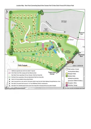
Illustrated touring-park plan with facilities, public footpaths and adjoining field-access details.
 Explore the map ↗
United Kingdom
Tree-framed mixed-accommodation park map with two entrances, touring loops and a clearly illustrated social hub.
Features may come from the sample artwork, its key or published park information. Approximate numbers describe the drawing and may cover only part of a park. They are intended to help you compare map examples. Current facilities and booking information should be checked with the park.
LET’S MAP YOUR PARK
For a map quotation, find your park and draw a rough boundary around it. The area you select helps us work out the design time and price.
Draw your park for a quote ↗Or talk to our map designers
01751 473136