
Planted lake edges
Reeds, small tree-covered islands or planted projections, and lifebuoy illustrations give the lakes a recognisable waterside character.
ILLUSTRATED PARK MAP · P488
Primrose Drive, Hambleton, Poulton-le-Fylde · United Kingdom
 Enlarge the map ↗
A SENSE OF THE PLACE
Hambleton Country Park is an owners-only holiday home and lodge park in the Fylde countryside. Its village location provides a quieter setting within reach of Lancashire's coastal resorts.
Holiday homeowners can use it as a base for outings towards Blackpool, Lytham St Annes and Cleveleys. The map shows the arrangement of lodge and holiday home plots and the routes through the grounds.
LOOK CLOSER
Reeds, small tree-covered islands or planted projections, and lifebuoy illustrations give the lakes a recognisable waterside character.
Continuous rows of stylised trees define much of the perimeter and separate several accommodation sections. Black fence lines reinforce selected boundaries.
Office symbols appear at the western arrival and service junction beside the play area, and at The Puddled Duck building in the south-east.
A named blue building with the bar/restaurant symbol stands beside the southern fishing lake and a substantial parking area.
Blue parking symbols identify spaces around the western service junction, within the yellow Sunset Park section and beside The Puddled Duck. Several areas include drawn parking bays.
An illustrated swing frame and slide mark a small tree-bordered play area near the western office and arrival junction.
Paired bin and recycling symbols are positioned beside the parking strip at the western service junction.
Repeated red fire-extinguisher symbols mark points distributed through the accommodation sections.
Office symbols appear at the western arrival and service junction beside the play area, and at The Puddled Duck building in the south-east.
A named blue building with the bar/restaurant symbol stands beside the southern fishing lake and a substantial parking area.
Blue parking symbols identify spaces around the western service junction, within the yellow Sunset Park section and beside The Puddled Duck. Several areas include drawn parking bays.
An illustrated swing frame and slide mark a small tree-bordered play area near the western office and arrival junction.
Paired bin and recycling symbols are positioned beside the parking strip at the western service junction.
Repeated red fire-extinguisher symbols mark points distributed through the accommodation sections.
Both blue water bodies are labelled Fishing and illustrated with fishing rods: an irregular northern lake within Lakeside and a long, narrow southern lake beside The Puddled Duck.
Reeds, small tree-covered islands or planted projections, and lifebuoy illustrations give the lakes a recognisable waterside character.
Continuous rows of stylised trees define much of the perimeter and separate several accommodation sections. Black fence lines reinforce selected boundaries.
Red arrows identify the Sunset Park entrance on the west and the Hambleton Country Park entrance from Sower Carr Lane along the southern edge.
Sower Carr Lane runs along the bottom of the plan, with a directional arrow towards the A558 and Hambleton.
Primrose Drive, Lilac Drive and Main Drive organise the green section; Meadow Point, Green Meadows, Lakeside and Sunset Park labels help identify routes through the other coloured sections.
A route labelled Footpath connects the Sower Carr Lane edge with the internal road near the southern parking and restaurant area.
Repeated red-ringed signs bearing 10 appear at entrances and internal junctions, matching the speed-limit entry in the symbol key.
READING THE MAP
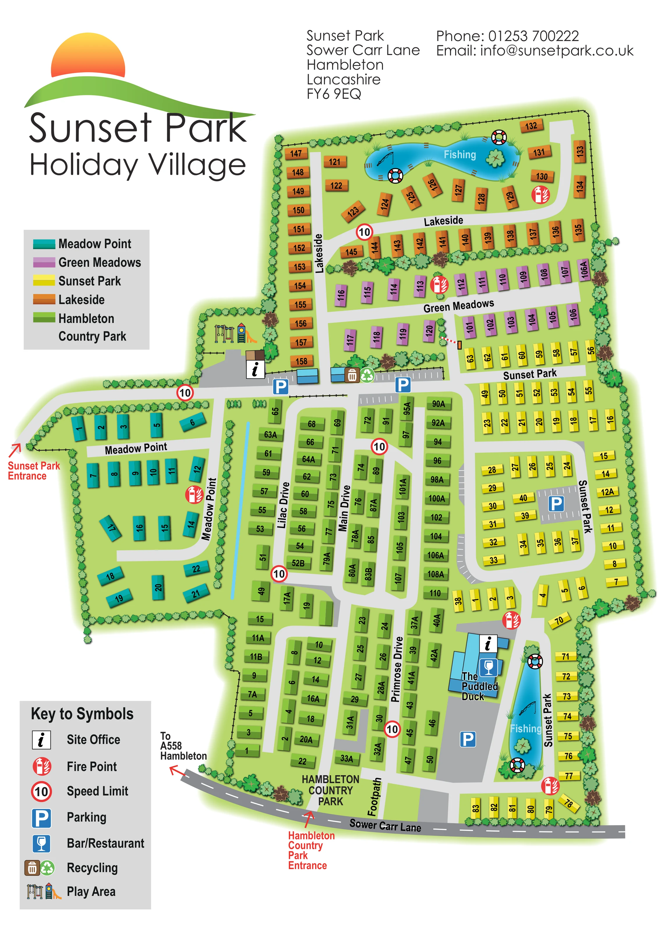
This colour-coded holiday park map places Hambleton Country Park within a wider plan headed Sunset Park Holiday Village. Set in Hambleton, Lancashire, the artwork brings five named accommodation areas together on one portrait page: Meadow Point, Green Meadows, Sunset Park, Lakeside and Hambleton Country Park. Each has its own unit colour, making the relationship between neighbouring sections immediately visible without changing the basic plot symbol.
The map combines numbered holiday-home plots with named drives, two clearly marked entrances and a compact set of facility symbols. Two fishing lakes give the site distinctive northern and southern landmarks, while The Puddled Duck, parking areas and a small illustrated play area help visitors recognise key destinations. Tree-lined boundaries and planted divisions soften the otherwise practical arrangement of roads and accommodation rows.
For a sample gallery, this is a useful example of mapping several linked park neighbourhoods within one coherent design. Its emphasis is on finding the right section, following the internal road network and locating shared facilities, rather than presenting individual buildings in architectural detail.
The plan is arranged around five coloured accommodation sections, with the green Hambleton Country Park area occupying much of the centre and south. Primrose Drive, Lilac Drive and Main Drive organise its parallel rows of numbered plots. A turquoise Meadow Point loop extends to the west, purple Green Meadows forms a band across the upper middle, and orange Lakeside wraps around the northern fishing lake. Yellow Sunset Park plots follow the eastern road loops and continue beside the long southern lake.
Arrival is explained with two red arrows: one marks the Sunset Park entrance on the western edge, while the other identifies the Hambleton Country Park entrance from Sower Carr Lane. The external road is drawn in dark grey with a dashed centre line and a direction towards the A558 and Hambleton. Internal drives use a much lighter grey, and a southern connection is explicitly labelled Footpath.
Facilities are distributed around recognisable junctions and landmarks. The western service area brings together an office symbol, parking, recycling and a tree-bordered play area illustrated with swings and a slide. The Puddled Duck is shown as a blue building beside the southern lake, accompanied by office and bar/restaurant symbols and a broad parking area. Further parking appears within the yellow section. Repeated fire-point and red-ringed 10 signs provide additional reference points.
The lakes contain Fishing labels, rod illustrations, reeds, planted features and lifebuoys. Scalloped trees and occasional fence lines define boundaries and divide neighbourhoods. A section-colour key and a separate facility legend sit to the left of the main plan. The detail views enlarge these same legend and southern-route elements; they are not separate map variants.
KEEP EXPLORING
Chosen for shared landscapes, accommodation or facilities.
 Explore the map ↗
United Kingdom
Illustrated lakeside park plan with numbered holiday units, leisure buildings and a looping Woodland Walk.
 Explore the map ↗
United Kingdom
Tree-lined accommodation blocks, lodge loops and a detailed cottage courtyard inset at Malvern View.
 Explore the map ↗
United Kingdom
Woodland park map with mixed pitches, bell tents, lodges and a fishing lake.
Features may come from the sample artwork, its key or published park information. Approximate numbers describe the drawing and may cover only part of a park. They are intended to help you compare map examples. Current facilities and booking information should be checked with the park.
LET’S MAP YOUR PARK
For a map quotation, find your park and draw a rough boundary around it. The area you select helps us work out the design time and price.
Draw your park for a quote ↗Or talk to our map designers
01751 473136