
River Tavy
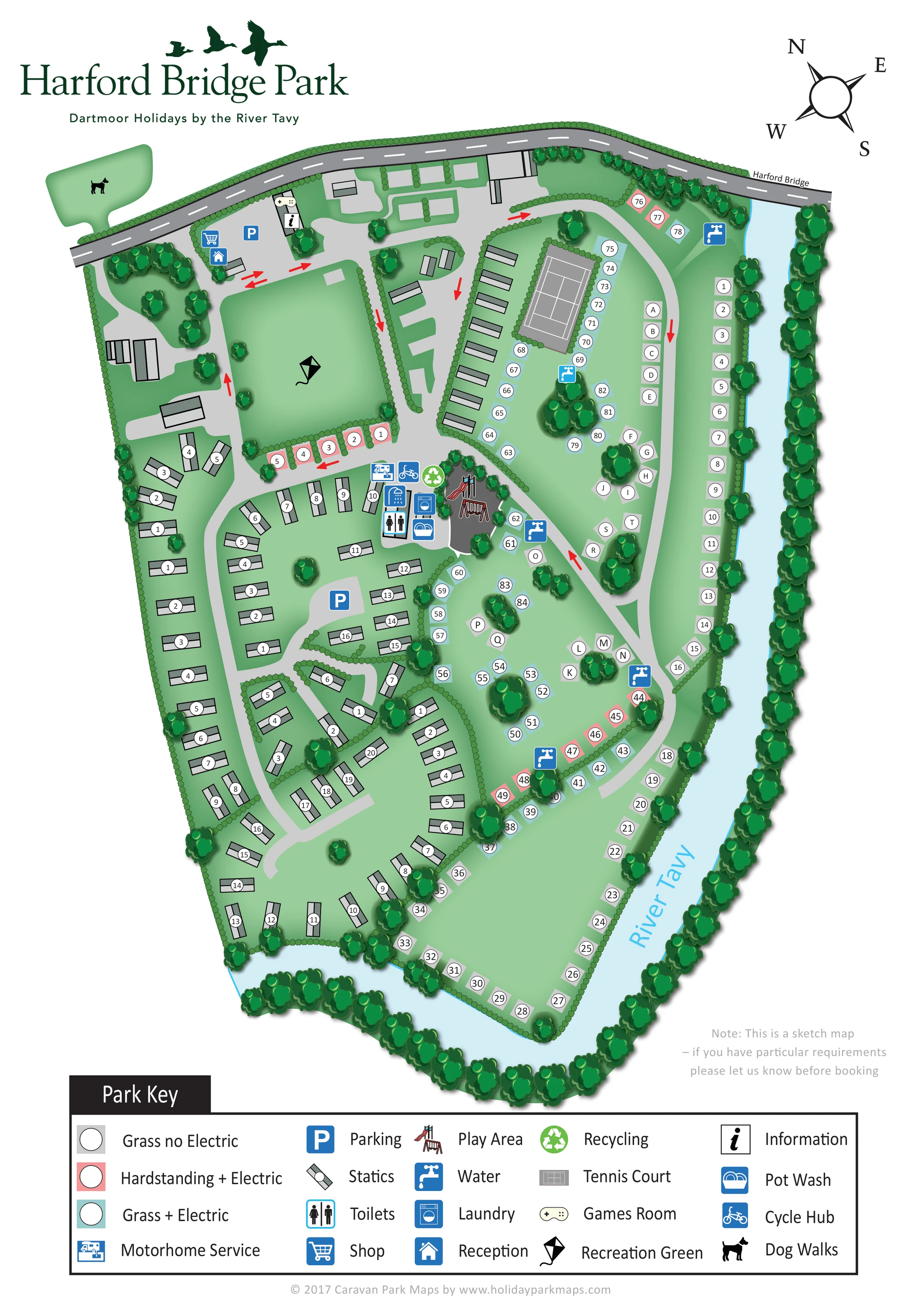
A labelled pale-blue river follows the right-hand boundary and curves around the bottom of the park.
ILLUSTRATED PARK MAP · P490
Peter Tavy, Tavistock, Devon · United Kingdom
 Enlarge the map ↗
A SENSE OF THE PLACE
Harford Bridge Holiday Park is located near Peter Tavy and Tavistock on the edge of Dartmoor. It provides camping, touring and fixed holiday accommodation, including caravans and pods.
Shared outdoor seating and table tennis add options for time on site. Accommodation access and pet arrangements vary between units. The location provides a base for exploring Tavistock and the walking landscapes of Dartmoor.
LOOK CLOSER
A labelled pale-blue river follows the right-hand boundary and curves around the bottom of the park.
Dense illustrated trees line the river and outer edges; smaller hedges divide accommodation groups and frame roads and shared spaces.
The grey public road crosses the top of the plan and the river at the labelled Harford Bridge.
Pale-grey branching and looping roads connect the accommodation areas; red arrows mark selected directions through the park.
A blue house symbol marks reception near the upper-left entrance area.
A shopping-trolley symbol places the shop beside reception.
Blue parking symbols mark an arrival-area parking space and another within the static caravan area.
An information symbol is positioned at a building near the top of the park.
A labelled pale-blue river follows the right-hand boundary and curves around the bottom of the park.
Dense illustrated trees line the river and outer edges; smaller hedges divide accommodation groups and frame roads and shared spaces.
The grey public road crosses the top of the plan and the river at the labelled Harford Bridge.
Pale-grey branching and looping roads connect the accommodation areas; red arrows mark selected directions through the park.
A blue house symbol marks reception near the upper-left entrance area.
A shopping-trolley symbol places the shop beside reception.
Blue parking symbols mark an arrival-area parking space and another within the static caravan area.
An information symbol is positioned at a building near the top of the park.
A controller symbol marks the games room near the information point.
A large rectangular green near the arrival area is identified by a kite symbol.
A grey court with white playing lines sits in a hedge-framed enclosure in the upper centre-right.
Illustrated slide and swing equipment marks the central play area beside the main service cluster.
Toilet and shower pictograms identify the central washroom facilities; the key explicitly names toilets.
A washing-machine symbol marks laundry facilities in the central service cluster.
A dishwashing symbol locates the pot wash beside the central washrooms and laundry.
A motorhome servicing pictogram appears at the upper edge of the central facilities.
A bicycle symbol identifies the cycle hub next to the motorhome service point.
A green recycling symbol is grouped with the central services.
Repeated blue tap symbols mark water points around the touring/camping areas.
A dog silhouette identifies a separate green area across the frontage road near the entrance. A detailed walking route is not drawn.
READING THE MAP
This illustrated map of Harford Bridge Holiday Park makes the River Tavy the defining feature of a mixed-accommodation site near Peter Tavy and Tavistock, on the edge of Dartmoor. The pale-blue river curves around the park, framed by dense trees, while a network of light-grey roads connects static caravan groups with touring and camping pitches.
The design gives visitors several clear ways to orient themselves. Reception, the shop and arrival parking are grouped near the entrance; a large recreation green provides an immediate landmark; and the tennis court and central facilities help explain the layout further into the site. Coloured pitch backgrounds distinguish grass without electric, grass with electric and hardstanding with electric, supported by numbered and lettered references.
A broad key beneath the plan explains the accommodation symbols and practical amenities, including water points, laundry, pot wash, motorhome servicing and the cycle hub. Dark-green branding, flying bird silhouettes and shaded trees give the page a recognisable riverside character without obscuring its wayfinding purpose.
The portrait artwork presents the park as an elongated riverside plan, with the frontage road running across its upper edge and crossing the River Tavy at Harford Bridge. The river follows the right-hand side before bending around the lower end, creating a strong visual boundary. Illustrated trees line the water and perimeter, while clipped hedge symbols separate smaller accommodation areas.
Arrival facilities sit towards the upper left. Reception and the shop share an area close to parking, with information and the games room shown nearby. A large recreation green, marked by a kite, occupies the space below. Across the frontage road, a separate green shape carries the dog-walk symbol.
Static caravans are drawn as grey-green rectangles in short rows and compact groups through the left and lower parts of the park. Another row runs beside the tennis court. Touring and camping pitch markers extend along the river and through the centre-right. Grey, turquoise and salmon-pink backgrounds identify the three pitch categories, while white circles contain numbers or letters. Red arrows stand out against the pale internal roads to indicate selected travel directions.
The central facilities bring together toilet and shower symbols, laundry, pot wash, motorhome servicing, recycling and the cycle hub. Play equipment is illustrated immediately alongside, and blue tap symbols identify water points throughout the pitch areas.
The composition finishes with a large Park Key, a compass and a short sketch-map note. The accompanying detail views enlarge portions of that same key; they are not separate park sections or alternative map designs.
KEEP EXPLORING
Chosen for shared landscapes, accommodation or facilities.
 Explore the map ↗
United Kingdom
Woodland park map with mixed pitches, bell tents, lodges and a fishing lake.
 Explore the map ↗
United Kingdom
Riverside park map with named pitch fields, illustrated huts and a paw-print dog walk.
 Explore the map ↗
United Kingdom
Woodland holiday homes, named camping fields and farm buildings on a colour-coded Nether Wasdale park map.
Features may come from the sample artwork, its key or published park information. Approximate numbers describe the drawing and may cover only part of a park. They are intended to help you compare map examples. Current facilities and booking information should be checked with the park.
TAKE A CLOSER LOOK
View the illustrated map in detail or choose a file to download. These are sample maps; contact the park for current visitor information.


LET’S MAP YOUR PARK
For a map quotation, find your park and draw a rough boundary around it. The area you select helps us work out the design time and price.
Draw your park for a quote ↗Or talk to our map designers
01751 473136