
Duck pond
A small blue pond is labelled beside the picnic area and facilities.
ILLUSTRATED PARK MAP · P491
Haw Wood Farm, Hinton, Saxmundham, Suffolk · United Kingdom
 Enlarge the map ↗
A SENSE OF THE PLACE
Haw Wood Farm Caravans and Camping is based at Haw Wood Farm, Hinton, Saxmundham, Suffolk. A motorhome service point and sheltered chemical-waste disposal point are provided.
Hot water and heating use a biomass boiler fuelled by locally sourced woodchips. Laundry, washing-up sinks and an ice-block freezer are available, with free Wi-Fi near the patio and facilities block. Washrooms have underfloor heating; three private family bathrooms and an accessible shower room are provided.
LOOK CLOSER
A small blue pond is labelled beside the picnic area and facilities.
The western edge carries a Woodland Walk & Flower Meadow label, with dense trees and flower illustrations; no separate detailed walking route is drawn.
A labelled dog-walking area sits along the lower western boundary, accompanied by a dog silhouette.
Three named grassy spaces break up the southern pitch blocks. The artwork spells the eastern name 'Hombeam Meadow'.
Continuous illustrated planting encloses the site and divides accommodation rows and meadow spaces.
An information symbol identifies the office within the orange-roofed arrival-side facilities cluster.
A shopping-trolley symbol marks the shop at the central facilities cluster.
Separate toilet and shower symbols identify facilities beside the office and shop.
An information symbol identifies the office within the orange-roofed arrival-side facilities cluster.
A shopping-trolley symbol marks the shop at the central facilities cluster.
Separate toilet and shower symbols identify facilities beside the office and shop.
The laundry symbol appears on the western side of the facilities cluster.
A washing-up symbol is placed beside the facilities buildings.
A pale sandy enclosure below the facilities contains illustrated climbing and slide equipment and swings.
A labelled enclosure with picnic-table illustrations lies west of the duck pond.
Two parasol-topped tables are illustrated immediately in front of the main facilities building.
Parking is marked beside the play area and at the labelled Late Arrivals space near the entrance.
A chemical-waste symbol appears on the western internal route near the narrow yellow pitch strip.
Repeated blue tap symbols are distributed around the pitch areas.
General-waste and recycling symbols are grouped near the duck pond and facilities.
Dog-waste symbols appear near the facilities, the western dog-walking area and the southern road junction.
Red fire-point symbols are repeated at key positions around the accommodation areas.
Circular signs displaying 5 are placed on several internal roads.
A red arrow identifies the access from the road along the northern edge.
The northern road is labelled towards London Road (A12) to the left and Dunwich Road and B1125 to the right.
A small blue pond is labelled beside the picnic area and facilities.
The western edge carries a Woodland Walk & Flower Meadow label, with dense trees and flower illustrations; no separate detailed walking route is drawn.
A labelled dog-walking area sits along the lower western boundary, accompanied by a dog silhouette.
Three named grassy spaces break up the southern pitch blocks. The artwork spells the eastern name 'Hombeam Meadow'.
Continuous illustrated planting encloses the site and divides accommodation rows and meadow spaces.
READING THE MAP
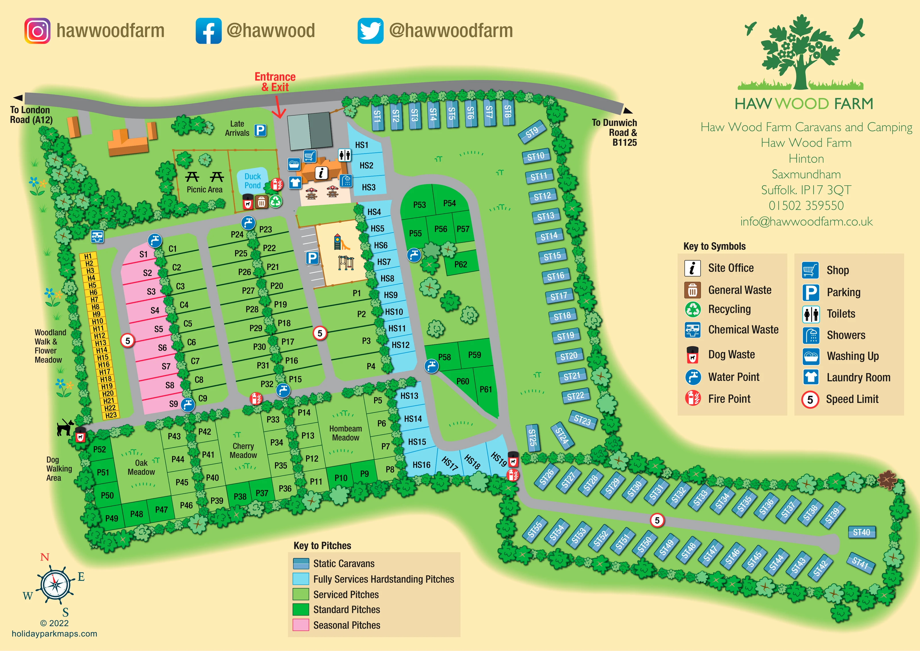
This illustrated map of Haw Wood Farm Caravans and Camping brings together a varied pitch layout and a leafy Suffolk setting. The plan shows the entrance from the northern road, a compact arrival and facilities hub, and accommodation extending through meadow-like spaces into a long static-caravan section on the eastern and southern sides. Colour is central to the design: serviced, standard, seasonal and fully serviced hardstanding pitches have distinct fills, while static caravans appear as individually labelled blue rectangles.
The landscape gives the map much of its character. Tree-lined boundaries, Oak and Cherry meadows, a woodland walk and flower meadow, and a small duck pond make the outdoor spaces easy to recognise. Practical destinations are equally prominent, including the office, shop, washrooms, laundry, picnic area and illustrated play equipment.
A separate facility key and pitch key support the detailed plan without crowding it. The park's tree-and-birds branding occupies a generous panel on the right, making this a useful sample for rural parks that need one visitor-facing map to explain accommodation choices, arrival arrangements and everyday facilities.
The map is arranged around an entrance on the road across the top of the page, with directions towards London Road (A12) and Dunwich Road and B1125. A red arrow leads into the arrival area, where late-arrival parking sits beside the main buildings. The office, shop, toilets, showers, laundry and washing-up facilities are identified by symbols around the orange-roofed hub. Nearby, a duck pond and labelled picnic enclosure provide recognisable landmarks, while parasol tables and a separate play enclosure add small illustrative details.
Grey roads divide and connect the accommodation. On the western side, a pink seasonal strip and green pitch rows sit inside planted boundaries. A narrow yellow H-labelled strip runs close to the woodland edge. Further south, pitches wrap around Oak Meadow, Cherry Meadow and the space labelled Hombeam Meadow. Cyan hardstanding pitches follow the central circulation route, with darker green standard pitches opposite. Blue static caravans trace the eastern boundary before continuing into a long southern wing with units on both sides of its access road.
Water points, fire points and dog-waste symbols recur across the plan. General waste and recycling are grouped near the facilities, and chemical-waste disposal is marked on the western route. Parking beside the play area and speed-limit symbols provide further practical reference points. The western margin identifies a woodland walk and flower meadow, with a dog-walking area lower down.
The single landscape artboard combines this detailed plan with a right-hand logo, contact panel and facility legend, plus a lower pitch key and compass. The accompanying close-ups enlarge parts of the same page rather than showing additional park sections.
KEEP EXPLORING
Chosen for shared landscapes, accommodation or facilities.
 Explore the map ↗
United Kingdom
Woodland-framed Barnsoul map with mixed accommodation, shared facilities and paw-marked walking routes.
 Explore the map ↗
United Kingdom
Woodland holiday-park map with named accommodation areas, touring loops and illustrated recreation facilities.
 Explore the map ↗
United Kingdom
A woodland estate park map combining caravan loops, touring pitches, riverside paths and Bruce’s Cave landmarks.
Features may come from the sample artwork, its key or published park information. Approximate numbers describe the drawing and may cover only part of a park. They are intended to help you compare map examples. Current facilities and booking information should be checked with the park.
LET’S MAP YOUR PARK
For a map quotation, find your park and draw a rough boundary around it. The area you select helps us work out the design time and price.
Draw your park for a quote ↗Or talk to our map designers
01751 473136