
Fishing lake
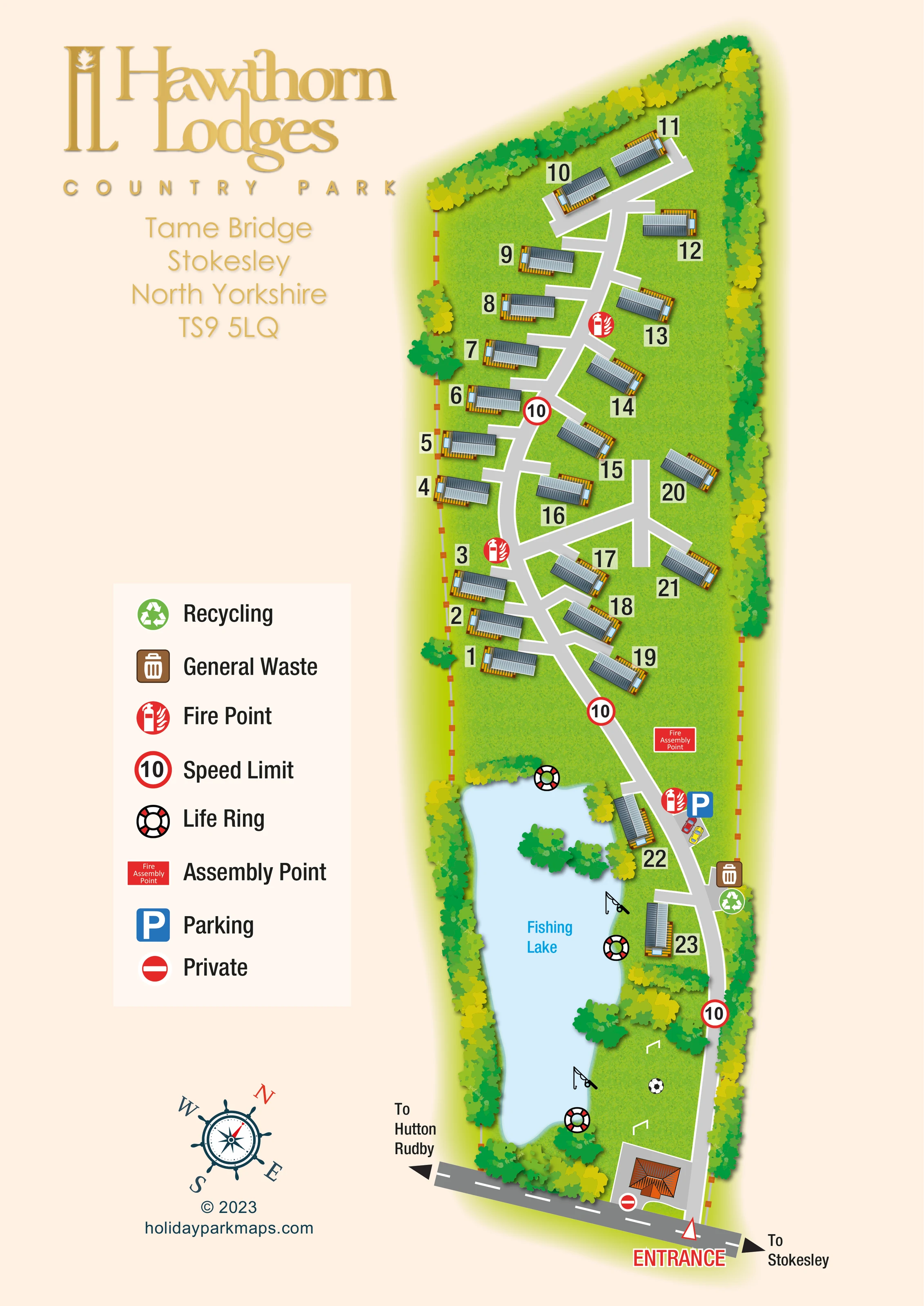
A large, elongated pale-blue lake occupies much of the lower part of the site. It is explicitly labelled Fishing Lake and accompanied by fishing-rod illustrations.
ILLUSTRATED PARK MAP · P155
Tame Bridge, Stokesley, North Yorkshire · United Kingdom
 Enlarge the map ↗
A SENSE OF THE PLACE
Hawthorn Lodges Country Park is a holiday lodge development near Stokesley in North Yorkshire. Private grounds, woodland trails and a fishing lake create a rural setting for holiday home ownership.
The park offers bespoke lodge options and access to countryside walks. Its map illustrates the arrangement of lodge plots and shared spaces, helping prospective owners understand the site before a visit.
LOOK CLOSER
A large, elongated pale-blue lake occupies much of the lower part of the site. It is explicitly labelled Fishing Lake and accompanied by fishing-rod illustrations.
Dense bands of broadleaf tree canopies frame the site, with additional clusters beside the lake and a wooded projection into its upper section.
Textured green ground separates the detached lodges and creates open areas between the accommodation, lake and internal road.
A football and two small white goal illustrations indicate a grassy football area near the entrance, between the lake and the access road.
A prominent red ENTRANCE label and outlined triangular marker identify the junction with the road along the bottom of the plan.
Black arrows at the ends of the external road point towards Stokesley and Hutton Rudby.
A curving grey road runs from the entrance past the eastern side of the lake into the main lodge area. Short branches serve individual units, with a larger side branch in the middle and a terminal branch at the far end.
A blue parking symbol and illustrated cars mark a small parking area beside the road near the upper end of the lake.
A large, elongated pale-blue lake occupies much of the lower part of the site. It is explicitly labelled Fishing Lake and accompanied by fishing-rod illustrations.
Dense bands of broadleaf tree canopies frame the site, with additional clusters beside the lake and a wooded projection into its upper section.
Textured green ground separates the detached lodges and creates open areas between the accommodation, lake and internal road.
A football and two small white goal illustrations indicate a grassy football area near the entrance, between the lake and the access road.
A prominent red ENTRANCE label and outlined triangular marker identify the junction with the road along the bottom of the plan.
Black arrows at the ends of the external road point towards Stokesley and Hutton Rudby.
A curving grey road runs from the entrance past the eastern side of the lake into the main lodge area. Short branches serve individual units, with a larger side branch in the middle and a terminal branch at the far end.
A blue parking symbol and illustrated cars mark a small parking area beside the road near the upper end of the lake.
Brown general-waste and green recycling symbols are grouped beside the internal road near the lakeside lodges.
Red fire-point symbols appear at intervals along the accommodation road, including beside the parking area.
A red Fire Assembly Point sign is positioned on open grass between the main lodge group and the parking area.
Life-ring symbols mark several positions around the lake edge.
Repeated red-bordered circles displaying 10 appear along the internal road; the legend identifies these as speed-limit symbols.
An orange-roofed building and grey forecourt sit beside the entrance. A red no-entry-style symbol, identified as Private in the legend, marks its frontage; no building function is named.
A nautical-style compass below the legend provides orientation, with north angled towards the upper right of the page.
Park information describes woodland trails and access to countryside walks. These are wider park context rather than separately drawn walking routes on this plan.
READING THE MAP
This illustrated map of Hawthorn Lodges Country Park presents a small holiday lodge development at Tame Bridge, near Stokesley in North Yorkshire. Its long, tree-lined layout is arranged around two clear elements: a numbered lodge neighbourhood in the upper part of the plan and a fishing lake nearer the entrance. A curving access road links them, making the relationship between accommodation, arrival and shared outdoor space easy to follow.
The portrait composition gives the park illustration its own tall column, balanced by prominent gold branding, an address block and a generous symbol key on the left. Grey-roofed lodges with golden-brown decking sit within textured green grounds, while layered tree canopies define the boundaries and soften the lake edge. Practical details include parking, recycling and general waste points, fire points, an assembly point and lakeside life rings. A small football area adds another recognisable landmark near arrival.
For a lodge park, this sample demonstrates how a compact development can be explained through individual accommodation illustrations and landscape features, without relying on a dense technical drawing.
The plan begins at the bottom of the page, where a bold red entrance label marks the junction with an external road. Direction arrows point towards Hutton Rudby and Stokesley. Just inside the site is an orange-roofed building with a grey forecourt and a private symbol; the artwork does not assign it a public-facing function. The main internal road curves beyond this building and follows the right-hand side of the fishing lake.
The lake occupies much of the lower site and is drawn in pale blue, with an irregular shoreline framed by trees. Fishing-rod illustrations reinforce its label, and life-ring symbols identify several lakeside positions. A grassy area near the entrance contains a football and two small goals. Further along the road, a small group of lakeside lodges sits close to parking and the paired recycling and general-waste symbols. A fire assembly point is marked on open grass beyond the lake's upper end.
Most accommodation lies in the upper half of the plan. Detached lodges are staggered on both sides of a gently curving spine road, with short individual access spurs and additional branches serving the middle and far end of the development. Each lodge has a slate-grey roof, golden-brown decking and a prominent black number on a pale background. Red fire-point icons and circular speed-limit markers stand out against the green grounds.
The single portrait artwork uses its left side for the gold park identity, address, eight-entry legend and decorative compass. Textured grass, layered tree canopies and soft shadows give the plan a landscaped character, while white-edged roads preserve a clear route structure. The enlarged views show details of this same composition, rather than additional sections or accommodation.
KEEP EXPLORING
Chosen for shared landscapes, accommodation or facilities.
 Explore the map ↗
United Kingdom
Illustrated lakeside pod map with woodland arrival routes, named lodges and a waterside circuit.
 Explore the map ↗
United Kingdom
Woodland park map with mixed pitches, bell tents, lodges and a fishing lake.
 Explore the map ↗
United Kingdom
Illustrated lakeside park plan with numbered holiday units, leisure buildings and a looping Woodland Walk.
Features may come from the sample artwork, its key or published park information. Approximate numbers describe the drawing and may cover only part of a park. They are intended to help you compare map examples. Current facilities and booking information should be checked with the park.
LET’S MAP YOUR PARK
For a map quotation, find your park and draw a rough boundary around it. The area you select helps us work out the design time and price.
Draw your park for a quote ↗Or talk to our map designers
01751 473136