
Ponds and ornamental water
A large irregular pond with two planted islands anchors the western leisure area. A small northern pond has a fountain motif, while a long narrow pond sits within the south-eastern accommodation loop.
ILLUSTRATED PARK MAP · P161
London Road, Nr.Lowestoft, Kessingland, Suffolk · United Kingdom
 Enlarge the map ↗
A SENSE OF THE PLACE
Heathland Beach Lodge Resort is an owners-only holiday park at Kessingland on the Suffolk coast. Direct beach access and sea views are central to its appeal.
Lodges provide a base for repeated coastal breaks, with Lowestoft and the surrounding Suffolk area available to explore. The map shows how the holiday home areas and internal routes relate to the coastal setting.
LOOK CLOSER
A large irregular pond with two planted islands anchors the western leisure area. A small northern pond has a fountain motif, while a long narrow pond sits within the south-eastern accommodation loop.
Dense mixed planting defines the park boundary, separates accommodation rows and subdivides the central pitches.
The eastern edge is labelled Sandy Beach and illustrated as a broad yellow strip beside bright blue water with a textured surf edge.
Information symbol on a blue-roofed building just inside the western entrance, beside illustrated parking.
Marked building immediately south of reception, forming part of the entrance-side service cluster.
A pale paved enclosure in the western leisure area contains a large rectangular pool, a smaller rectangular pool and a circular water feature, with a swimming symbol and adjacent blue-roofed structures.
Two pale, orange-edged play spaces with swing illustrations: one in the western leisure area and one among the central pitches.
A blue dumbbell symbol identifies a brown rectangular exercise area beside the tennis court.
Information symbol on a blue-roofed building just inside the western entrance, beside illustrated parking.
Marked building immediately south of reception, forming part of the entrance-side service cluster.
A pale paved enclosure in the western leisure area contains a large rectangular pool, a smaller rectangular pool and a circular water feature, with a swimming symbol and adjacent blue-roofed structures.
Two pale, orange-edged play spaces with swing illustrations: one in the western leisure area and one among the central pitches.
A blue dumbbell symbol identifies a brown rectangular exercise area beside the tennis court.
Green court with white tennis markings and a brown surround in the south-western leisure area.
A green rectangular playing area with goal boxes and centre-circle markings beside the western play area.
A barbecue symbol marks a dedicated space within the central pitches; picnic-table illustrations also appear beside the pool enclosure.
A bicycle symbol is positioned at the northern end of the central play space.
Two mapped service clusters lie at the northern and southern edges of the central pitch area.
Washing-machine symbol beside the northern shower and toilet cluster.
Disposal symbols appear at both central pitch service clusters.
Red fire-point symbols identify locations around the northern central service block.
Adjacent waste and recycling symbols are placed close to the eastern entrance, at the southern end of the central pitches.
A red-and-black dog waste bin symbol is shown near the southern shower and toilet block.
A small blue-roofed building south of the bar and restaurant carries the rental-accommodation symbol used in the legend.
Groups of coloured car illustrations identify parking beside the pool, reception, central service block and northern coastal accommodation.
A large irregular pond with two planted islands anchors the western leisure area. A small northern pond has a fountain motif, while a long narrow pond sits within the south-eastern accommodation loop.
Dense mixed planting defines the park boundary, separates accommodation rows and subdivides the central pitches.
The eastern edge is labelled Sandy Beach and illustrated as a broad yellow strip beside bright blue water with a textured surf edge.
A southern 'To The Beach' arrow, wave motif and footprint trail indicate beachward movement. A pale paired track also crosses the eastern green margin towards the sand.
Two timber-style ENTRANCE signs and red triangular markers identify access points from the grey road along the southern boundary.
A left-pointing external direction label connects the southern frontage road with the B1437 and Kessingland.
White roads form loops and branches between accommodation areas. Blue arrows indicate circulation around the central pitches, and red-ringed 10 signs recur along internal routes.
READING THE MAP
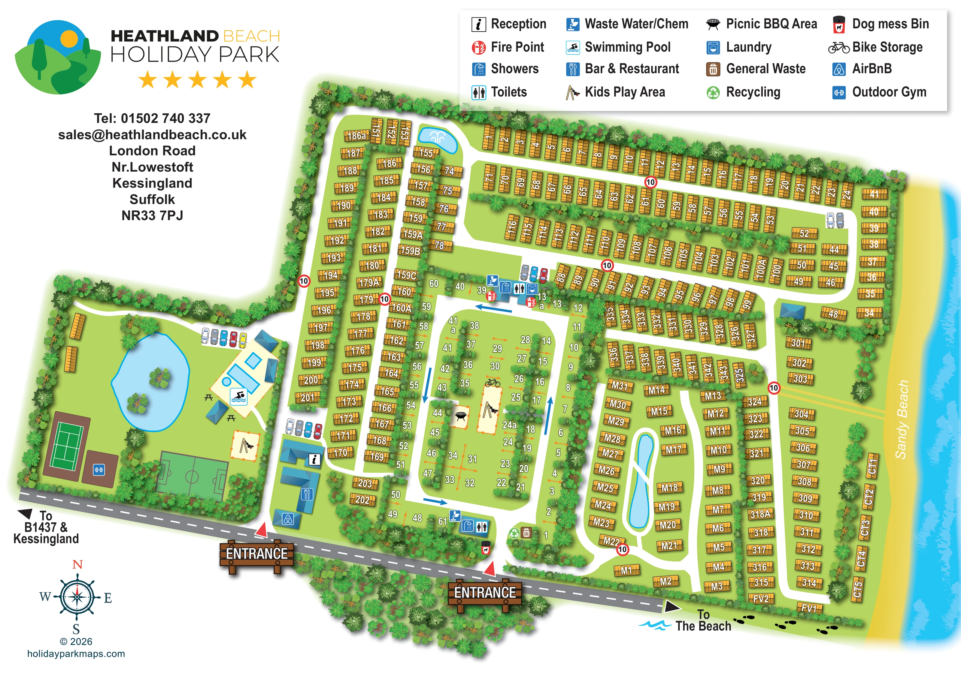
This illustrated map of Heathland Beach Holiday Park places the Suffolk coast at the centre of the visitor experience. A broad sandy beach and bright blue sea run along the eastern edge, while planted accommodation rows, internal roads and leisure spaces explain how the park fits together inland. Two prominent entrance signs establish arrival points from the southern road, with reception and the bar and restaurant grouped beside the western entrance.
The plan combines a substantial holiday-home layout with a central area of numbered open pitches. Rather than presenting every part of the site in the same way, it uses golden roofs for fixed accommodation, blue roofs for service buildings and clear white roads between green landscaped areas. The western leisure enclosure is particularly distinctive: pools, a large pond with planted islands, tennis and football areas, an outdoor gym and a children's play space create a recognisable cluster of landmarks.
A generous facility key, outlined plot numbers and beachward directions make this a useful sample for coastal parks that need to explain both accommodation organisation and shared facilities within one illustrated overview.
The single landscape plan shows the park between a southern frontage road and the sandy shoreline on the right. Fixed accommodation occupies long planted rows across the north, narrower strips to the west and several coastal groups to the east. In the lower-right area, a curving road encloses a long, slim pond, creating a distinctive landmark among the numbered holiday homes. A smaller northern pond includes a fountain motif.
The central section is drawn differently, with numbered open pitches and orange markers separated by belts of shrubs. Blue arrows describe circulation around this area. Shower and toilet buildings sit at its northern and southern edges, with waste-water and chemical-disposal symbols at both clusters. Laundry and fire-point symbols appear at the northern block; general waste, recycling and a dog waste bin are marked near the southern entrance-side services. A children's play space, bicycle-storage symbol and barbecue area sit within the pitch layout.
The western leisure enclosure contains an irregular pond with two planted islands, a paved pool complex, picnic tables, a tennis court, a football pitch, an outdoor gym and another play area. Reception, the bar and restaurant and an AirBnB-marked building stand beside the western entrance, with illustrated cars identifying nearby parking.
Two oversized timber-style entrance signs connect the plan to the grey external road. A direction label points towards the B1437 and Kessingland, while a separate beach arrow, wave motif and footprint trail emphasise coastal access. The upper-right legend explains 16 facility symbols; branding and contact information occupy the upper left. The enlarged detail views show portions of this same artwork rather than additional park sections.
KEEP EXPLORING
Chosen for shared landscapes, accommodation or facilities.
 Explore the map ↗
United Kingdom
A colour-zoned coastal park map with touring areas, woodland trails, ponds and a leisure club.
 Explore the map ↗
United Kingdom
Colour-coded accommodation, central leisure facilities and coastal paths on an illustrated headland park map.
 Explore the map ↗
United Kingdom
Trevornick’s colour-coded park map, with mixed accommodation, fishing ponds, golf and wooded trails.
Features may come from the sample artwork, its key or published park information. Approximate numbers describe the drawing and may cover only part of a park. They are intended to help you compare map examples. Current facilities and booking information should be checked with the park.
LET’S MAP YOUR PARK
For a map quotation, find your park and draw a rough boundary around it. The area you select helps us work out the design time and price.
Draw your park for a quote ↗Or talk to our map designers
01751 473136