
No dog walking area
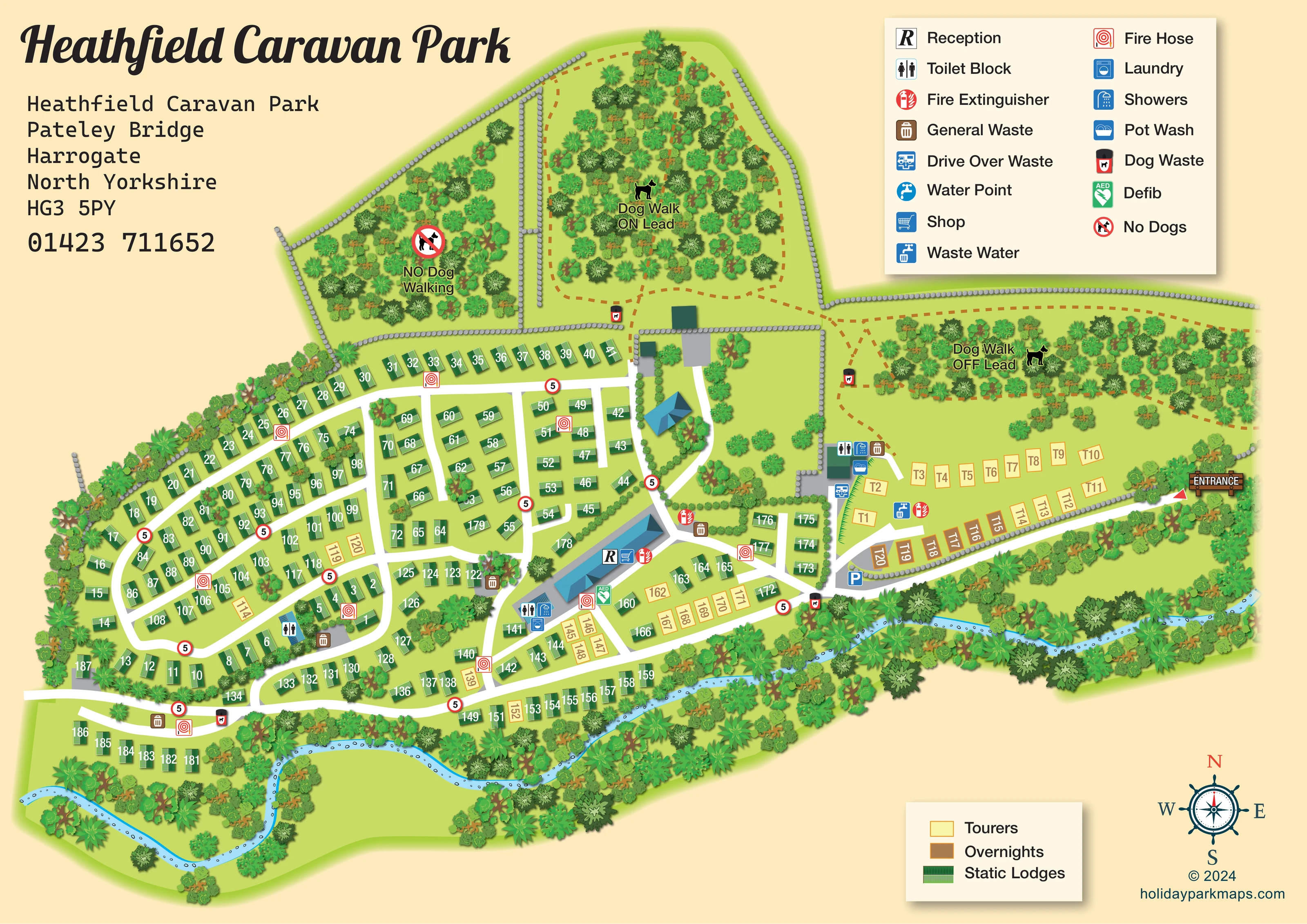
A separate upper-left wooded enclosure is labelled 'NO Dog Walking' and carries a prohibition symbol.
ILLUSTRATED PARK MAP · P160
Heathfield Caravan Park, Pateley Bridge, Harrogate, North Yorkshire · United Kingdom
 Enlarge the map ↗
A SENSE OF THE PLACE
Heathfield Caravan Park is a family-owned site in Upper Nidderdale near Pateley Bridge. It offers holiday home ownership and hardstanding touring pitches in a countryside setting on the Nidderdale Way.
A library, laundry and electric touring connections provide practical facilities. Walks start close to the park, with cycling, fishing and riding opportunities described in the surrounding area.
LOOK CLOSER
A separate upper-left wooded enclosure is labelled 'NO Dog Walking' and carries a prohibition symbol.
Dense illustrated trees enclose the walking areas, soften the accommodation groups and line the southern watercourse.
An unnamed pale-blue, pebble-detailed watercourse follows the southern edge and makes a pronounced bend around the south-western green space.
Repeated grey stone shapes define woodland enclosures, service grounds and the edge of the eastern touring area.
An R symbol identifies reception in the long blue-roofed building near the centre-right road junction.
A shopping-trolley symbol marks the shop alongside reception.
Toilet symbols mark facilities beside the eastern touring area, near the reception complex and within the western accommodation area.
Shower symbols are positioned at the eastern touring service building and beside the central facilities.
An R symbol identifies reception in the long blue-roofed building near the centre-right road junction.
A shopping-trolley symbol marks the shop alongside reception.
Toilet symbols mark facilities beside the eastern touring area, near the reception complex and within the western accommodation area.
Shower symbols are positioned at the eastern touring service building and beside the central facilities.
A blue laundry symbol appears beside the central toilet and shower facilities.
A washing-up symbol marks the eastern touring service building.
A vehicle-and-drain symbol marks a disposal point beside the eastern service building.
A waste-water symbol is shown near the first pitches in the eastern touring area.
The facility key includes a water-point symbol; a separate matching position is not clearly identifiable on the plan.
Brown bin symbols are distributed beside facilities and road junctions throughout the accommodation areas.
Black-and-red dog waste symbols appear near the woodland walks and along the lower road.
Red hose and extinguisher symbols are distributed along accommodation roads and beside service buildings.
A green AED symbol is shown beside the reception and central facilities.
A blue P symbol marks parking at the western end of the eastern touring area.
A timber-style ENTRANCE sign and red arrow identify the arrival road at the right-hand edge.
White roads connect the eastern entrance to reception, branching accommodation lanes and broad western loops. Red-bordered circular 5 signs recur along the routes.
The upper central woodland is labelled 'Dog Walk ON Lead', with an ochre dashed loop and a connecting path.
The long woodland strip above the eastern touring pitches is labelled 'Dog Walk OFF Lead' and contains dashed walking routes.
A separate upper-left wooded enclosure is labelled 'NO Dog Walking' and carries a prohibition symbol.
Dense illustrated trees enclose the walking areas, soften the accommodation groups and line the southern watercourse.
An unnamed pale-blue, pebble-detailed watercourse follows the southern edge and makes a pronounced bend around the south-western green space.
Repeated grey stone shapes define woodland enclosures, service grounds and the edge of the eastern touring area.
Published park information mentions a library; it is not separately labelled on this artwork.
Published park information describes electric connections for touring pitches; these are not individually mapped.
READING THE MAP
This illustrated map of Heathfield Caravan Park presents a countryside holiday park near Pateley Bridge in North Yorkshire. Green static accommodation fills a network of looping lanes, while a smaller touring area sits beside the clearly marked eastern entrance. A winding blue watercourse and richly illustrated planting give the plan a strong landscape identity without obscuring its practical purpose.
The woodland above the accommodation is an important part of the design. Dashed paths distinguish the mapped on-lead and off-lead dog walks, while a separate wooded enclosure is marked as a no-dog-walking area. These spaces are presented as recognisable destinations rather than anonymous green margins.
Reception, the shop, wash facilities, waste points and safety equipment are located using compact pictograms. Two separate keys explain the facilities and accommodation colours, keeping the dense plan manageable. With its large italic title, cream background and decorative compass, this sample combines an inviting park portrait with the detailed route and pitch information needed for everyday visitor orientation.
The plan follows Heathfield's irregular footprint, with arrival at the right-hand edge and most accommodation extending westwards. A timber-style entrance sign and red arrow introduce the white access road, which passes beneath the eastern touring pitches before joining the main internal network. Yellow touring plots occupy two loose rows here, with a short brown overnight row beside the road. Parking and a compact service building are marked at the western end of this section.
Further into the park, a long blue-roofed building carries the reception and shop symbols. Nearby icons identify toilets, showers, laundry and a defibrillator. The eastern service area includes toilets, showers, pot washing and drive-over waste disposal. General waste, dog waste and fire-equipment symbols are distributed around the wider plan, while repeated red-bordered 5 signs punctuate the roads.
Green static units sit in angled rows and smaller clusters around branching lanes and broad western loops. Additional yellow touring pitches appear among these groups. White numbers overlay the roof illustrations, and pitch labels follow the angle of each rectangular symbol.
Above the accommodation, grey stone boundaries divide wooded enclosures. Ochre dashed paths loop through the area labelled for on-lead dog walking and continue into the long off-lead woodland strip above the touring pitches. A separate upper-left enclosure is marked 'NO Dog Walking'. Below the accommodation, an unnamed blue watercourse winds through dense planting and bends around an open green area.
The single landscape artwork places its title and contact block at the upper left, a large facility key at the upper right, and a smaller accommodation key and compass below. Layered tree canopies, ribbed green roofs and softly shadowed legend panels give the otherwise diagrammatic plan texture and depth.
KEEP EXPLORING
Chosen for shared landscapes, accommodation or facilities.
 Explore the map ↗
United Kingdom
Illustrated farm campsite map with touring pitches, pods, camping fields and a riverside dog-walk route.
 Explore the map ↗
United Kingdom
A woodland estate park map combining caravan loops, touring pitches, riverside paths and Bruce’s Cave landmarks.
 Explore the map ↗
United Kingdom
Woodland park map with mixed pitches, bell tents, lodges and a fishing lake.
Features may come from the sample artwork, its key or published park information. Approximate numbers describe the drawing and may cover only part of a park. They are intended to help you compare map examples. Current facilities and booking information should be checked with the park.
LET’S MAP YOUR PARK
For a map quotation, find your park and draw a rough boundary around it. The area you select helps us work out the design time and price.
Draw your park for a quote ↗Or talk to our map designers
01751 473136