
Dog walk and nature trail
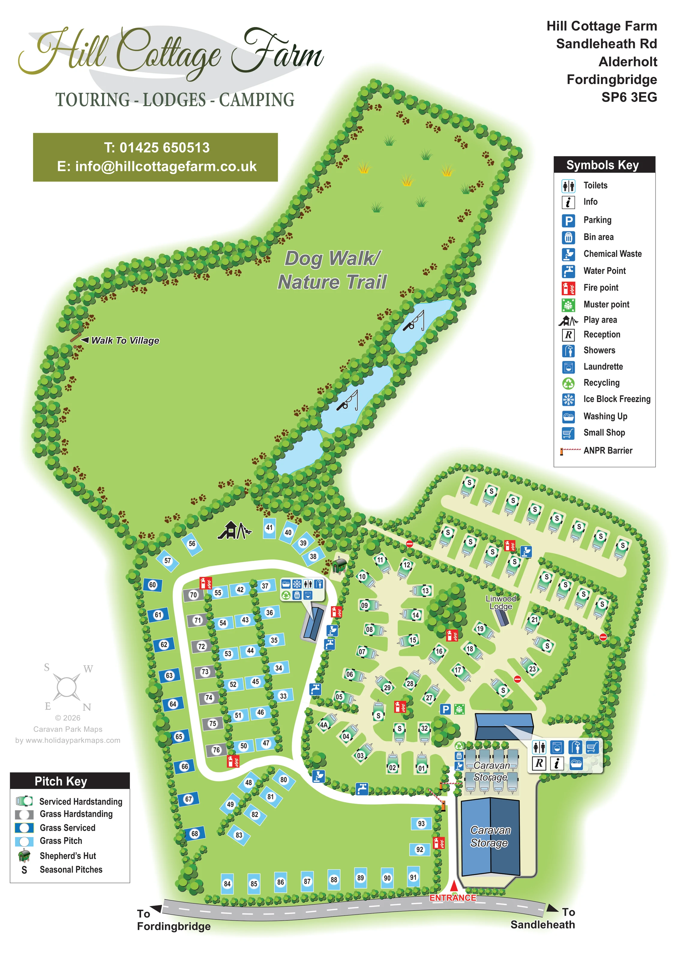
A large irregular green area occupies the upper half of the composition and is labelled Dog Walk/Nature Trail.
ILLUSTRATED PARK MAP · P166
Hill Cottage Farm, Sandleheath Rd, Alderholt, Fordingbridge · United Kingdom
 Enlarge the map ↗
A SENSE OF THE PLACE
Hill Cottage Farm is based at Sandleheath Rd, Alderholt, Fordingbridge. This is a family-owned park in 40 acres of Dorset countryside near the New Forest. Touring pitches, tent camping, a lodge and a shepherd's hut are offered. Fully serviced hardstanding pitches have dividing hedges; electric camping pitches are also available.
Facilities include showers, family bathroom, covered washing-up area, freezer, laundry and children's play area.
LOOK CLOSER
A large irregular green area occupies the upper half of the composition and is labelled Dog Walk/Nature Trail.
Three blue ponds follow the wooded edge between the nature area and accommodation. Fishing-rod pictograms appear on two ponds; the artwork does not state fishing arrangements.
Continuous stylised tree belts enclose the park, frame the ponds and divide accommodation areas. Short hedges separate several rows of pitches.
Reception and information symbols are grouped beside the entrance-side facilities building.
A shopping-trolley symbol places the small shop within the entrance-side facilities cluster.
Toilet and shower symbols appear at both the entrance-side building and the smaller block beside the left-hand pitch loop.
Laundry symbols are attached to the two main facilities clusters.
Washing-up symbols appear beside the entrance facilities and the block serving the left-hand pitches.
Reception and information symbols are grouped beside the entrance-side facilities building.
A shopping-trolley symbol places the small shop within the entrance-side facilities cluster.
Toilet and shower symbols appear at both the entrance-side building and the smaller block beside the left-hand pitch loop.
Laundry symbols are attached to the two main facilities clusters.
Washing-up symbols appear beside the entrance facilities and the block serving the left-hand pitches.
A snowflake symbol identifies ice block freezing at the facilities block within the left-hand loop.
Repeated tap and chemical-waste symbols identify service points along the internal routes and beside facilities.
Bin symbols occur near the facilities and storage area; recycling is marked at the left-hand facilities cluster.
Red fire-point markers are distributed around the pitch areas. A green muster-point marker sits beside parking near the entrance-side building.
A blue parking symbol is positioned beside the entrance-side building and central hardstanding area.
A play-equipment pictogram marks a grassy space at the upper edge of the left-hand pitch area, beside the nature-trail land.
Both a large blue-roofed building and an adjacent group of stored caravans are labelled Caravan Storage near the entrance.
A large irregular green area occupies the upper half of the composition and is labelled Dog Walk/Nature Trail.
Three blue ponds follow the wooded edge between the nature area and accommodation. Fishing-rod pictograms appear on two ponds; the artwork does not state fishing arrangements.
Continuous stylised tree belts enclose the park, frame the ponds and divide accommodation areas. Short hedges separate several rows of pitches.
A labelled arrow on the left edge of the nature area indicates a walk to the village without specifying a distance or detailed off-site route.
The road entrance is marked in red beside the storage building. Red-and-white barrier illustrations identify controlled access on the internal approach.
The grey frontage road has directional arrows to Fordingbridge on the left and Sandleheath on the right.
READING THE MAP
This illustrated map of Hill Cottage Farm brings together a varied touring and camping layout with the countryside that gives the park its character. Located at Alderholt near Fordingbridge, the park is shown as a tree-enclosed collection of pitches beneath an extensive dog-walking and nature-trail area. A chain of blue ponds follows the wooded boundary between these two parts of the site, making the landscape a prominent feature rather than a small background detail.
The accommodation is explained through a dedicated pitch key covering serviced hardstanding, grass hardstanding, grass serviced and grass pitches, alongside seasonal markers and a shepherd’s hut illustration. Linwood Lodge is also named on the plan. Visitors can follow the entrance from the frontage road, identify caravan storage and reception, then use the internal roads and numbered pitch markers to orient themselves.
The portrait composition balances practical detail with distinctive branding: a large script heading, olive contact panel, separate facilities key and softly shaded tree belts. It is a useful sample for countryside parks that need to explain several pitch options while giving walking space, water features and arrival landmarks equal visual importance.
The map is arranged around two contrasting areas. In the lower half, white internal roads serve a compact network of touring and grass pitches. Above them, a broad irregular green space is labelled Dog Walk/Nature Trail, enclosed by dense rows of stylised trees. Three ponds sit along its right-hand wooded edge, with fishing-rod illustrations on two of the water features. A Walk To Village arrow identifies an outward connection on the opposite boundary.
Arrival is shown from the grey road across the foot of the page, with arrows towards Fordingbridge and Sandleheath. A red entrance marker leads past the large caravan-storage building and an outdoor storage area. Barrier graphics distinguish the controlled internal access points. Reception, information, the small shop, toilets, showers, laundry and washing-up facilities are grouped beside the entrance-side building, with parking and a muster point nearby.
A rounded road loop serves the left-hand pitches, where hedges separate several internal rows. A second facilities block carries symbols for toilets, showers, washing up, ice block freezing, laundry, bins and recycling. Water points, chemical-waste points and red fire markers are distributed through the accommodation area. The play area occupies a green space at the transition towards the nature-trail land.
On the right, illustrated caravans sit on serviced hardstanding shapes, with long S-marked seasonal rows above. Linwood Lodge is named within this area, while a small shepherd’s hut illustration stands near the wooded junction. Blue and grey pitch rectangles, white number discs and separate pitch and facilities keys keep the different spaces legible. The accompanying detail views enlarge the lower pitch key and entrance/storage area; they are close-ups of the same portrait design, not separate park sections.
KEEP EXPLORING
Chosen for shared landscapes, accommodation or facilities.
 Explore the map ↗
United Kingdom
A woodland estate park map combining caravan loops, touring pitches, riverside paths and Bruce’s Cave landmarks.
 Explore the map ↗
United Kingdom
Woodland-framed Barnsoul map with mixed accommodation, shared facilities and paw-marked walking routes.
 Explore the map ↗
United Kingdom
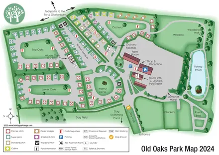
Colour-coded touring and glamping map with hedge-lined pitch groups, a fishing pond and detailed dog facilities.
Features may come from the sample artwork, its key or published park information. Approximate numbers describe the drawing and may cover only part of a park. They are intended to help you compare map examples. Current facilities and booking information should be checked with the park.
TAKE A CLOSER LOOK
View the illustrated map in detail or choose a file to download. These are sample maps; contact the park for current visitor information.


LET’S MAP YOUR PARK
For a map quotation, find your park and draw a rough boundary around it. The area you select helps us work out the design time and price.
Draw your park for a quote ↗Or talk to our map designers
01751 473136