
Fishing pond
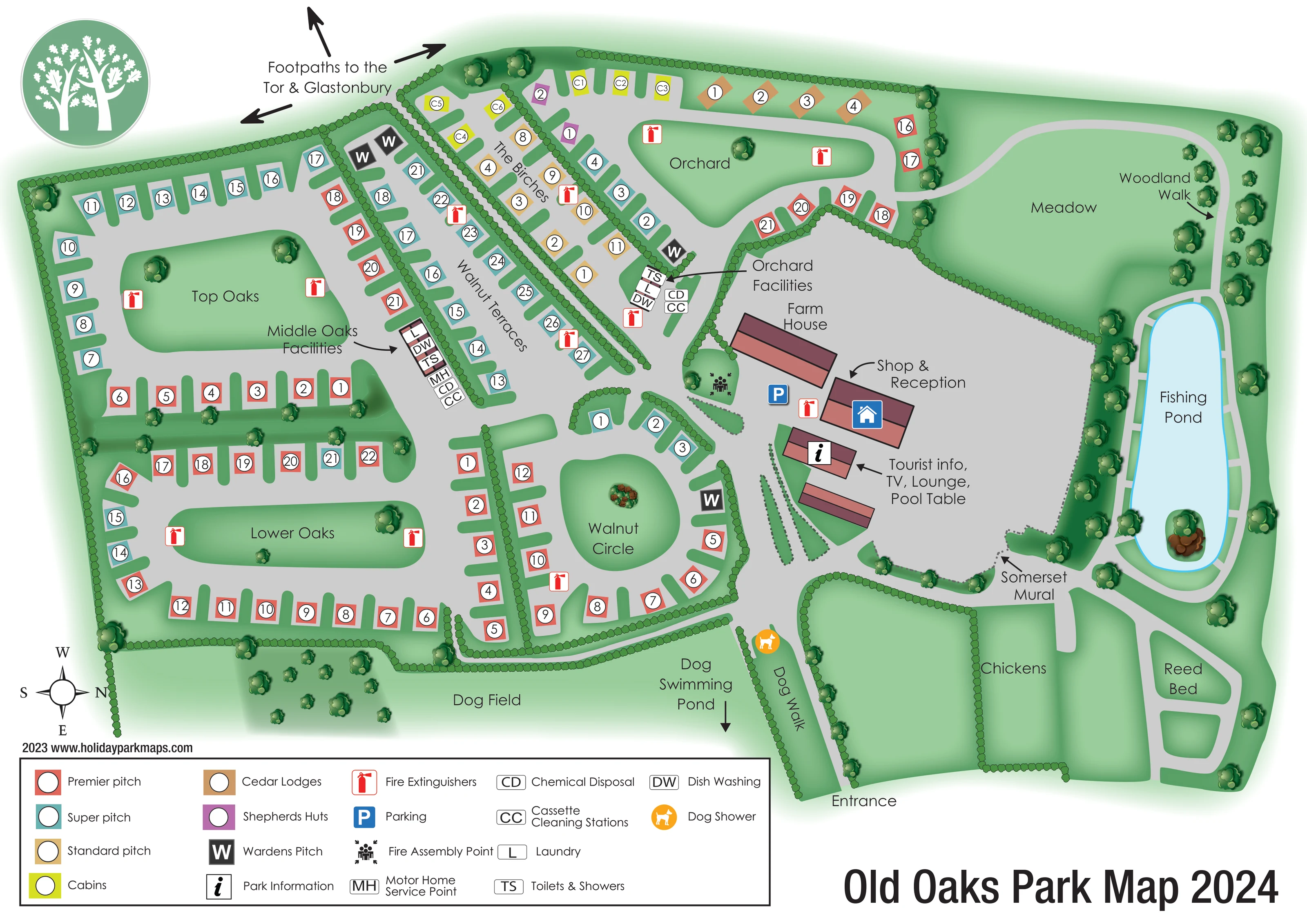
A long pale-blue pond with a small planted island occupies the right-hand side of the plan, enclosed by a looping path.
ILLUSTRATED PARK MAP · P236
Wick Farm, Wick, Glastonbury, Somerset · United Kingdom
 Enlarge the map ↗
A SENSE OF THE PLACE
Old Oaks offers adults-only touring, camping and glamping near Glastonbury in Somerset. Spacious pitches and fixed glamping accommodation sit within a countryside setting.
A shared lounge includes a self-service bar, television, pool table and darts. Takeaway and visiting food options add convenience, while Glastonbury and the surrounding Somerset landscape provide opportunities for outings beyond the park.
LOOK CLOSER
A long pale-blue pond with a small planted island occupies the right-hand side of the plan, enclosed by a looping path.
A large unnumbered green space lies above the central courtyard, beside the woodland walk.
A broad green strip below the main pitch groups is labelled Dog Field.
A hedge-divided green area beside the entrance is labelled Chickens.
A green compartment below the fishing pond is labelled Reed Bed.
A labelled building in the central arrival courtyard, reinforced by a blue house symbol.
These shared facilities are grouped in a labelled building beside shop and reception.
A blue P symbol identifies parking in the courtyard near the farmhouse and reception.
A labelled building in the central arrival courtyard, reinforced by a blue house symbol.
These shared facilities are grouped in a labelled building beside shop and reception.
A blue P symbol identifies parking in the courtyard near the farmhouse and reception.
Middle Oaks Facilities and Orchard Facilities both carry TS, L and DW labels, explained in the legend.
CD and CC markers appear beside both mapped facility clusters.
An MH marker is placed at Middle Oaks Facilities.
Red extinguisher icons are distributed through the pitch groups and courtyard; a black assembly symbol sits near the farmhouse.
Black W markers identify wardens' positions among the accommodation groups.
A long pale-blue pond with a small planted island occupies the right-hand side of the plan, enclosed by a looping path.
A large unnumbered green space lies above the central courtyard, beside the woodland walk.
A labelled tree-lined route curves around the meadow and connects towards the fishing pond.
A broad green strip below the main pitch groups is labelled Dog Field.
The hedge-lined entrance corridor is labelled Dog Walk.
An orange dog symbol marks the shower beside the entrance corridor.
A labelled arrow points beyond the lower edge of the drawn dog-field area; the pond itself is not illustrated.
A hedge-divided green area beside the entrance is labelled Chickens.
A green compartment below the fishing pond is labelled Reed Bed.
A callout identifies the mural along the lower-right edge of the central courtyard.
A large roof-shaped building is labelled Farm House beside the arrival facilities; it is not identified as guest accommodation.
The lower-edge entrance leads into the central courtyard and branches towards the pitch loops and landscape paths.
Large outward arrows at the upper-left boundary indicate connections beyond the park without plotting complete external routes.
READING THE MAP
This Old Oaks map brings together a touring and glamping park near Glastonbury with the countryside spaces that help define its character. The plan is dominated by hedge-separated pitch groups, each given a clear name and a colour-coded accommodation key. Top Oaks, Lower Oaks, Walnut Terraces, Walnut Circle, The Birches and Orchard provide recognisable destinations rather than leaving visitors to navigate by pitch numbers alone.
The central courtyard gathers shop and reception, tourist information and the lounge facilities, while the right-hand side opens into a meadow, woodland walk and a long fishing pond. Dog-related features receive unusually detailed attention: the artwork marks a dog field, an entrance-side dog walk and shower, plus a direction towards the dog swimming pond. Footpath arrows also connect the park with the Tor and Glastonbury.
Visually, the design combines a practical overhead plan with softly shaded trees, green lawns and simple roof illustrations. Its broad grey routes, generous legend and distinct accommodation colours make it a useful example for countryside parks that need to explain both their pitch layout and their outdoor attractions.
The single-page plan shows arrival from the lower edge, following a hedge-lined corridor into the main courtyard. Shop and reception sit beside the farmhouse, parking and a separate building labelled for tourist information, television, lounge and pool table. A Somerset mural is identified at the courtyard edge, adding a distinctive landmark to the arrival area.
Most accommodation lies to the left and above this hub. Top Oaks and Lower Oaks form broad loops around green islands, Walnut Circle creates a smaller rounded group, and Walnut Terraces and The Birches organise pitches along straighter lanes. Hedge bands separate these sections without obscuring their connections. Premier, Super and Standard pitches use coral, teal and ochre markers, each containing a white number circle. Lime-yellow cabins, purple shepherds' huts and warm-brown Cedar Lodges distinguish the fixed accommodation near Orchard.
Two labelled facility clusters, Middle Oaks and Orchard, bring together toilets and showers, laundry, dish washing, chemical disposal and cassette cleaning. A motorhome service point is marked at Middle Oaks. Red extinguisher icons appear across the plan, with the assembly point near the farmhouse and black W markers identifying wardens' pitches.
The landscape occupies a substantial part of the composition. A woodland route curves around the meadow towards the fishing pond, whose pale-blue water contains a planted island. Below it are a labelled reed bed and chickens area. The dog field stretches beneath the pitch groups; a dog shower sits beside the entrance-side walk, and an arrow indicates the dog swimming pond beyond the drawn area. External footpath arrows point towards the Tor and Glastonbury. The oak roundel, rotated compass, bottom legend and bold 2024 title complete the artwork.
KEEP EXPLORING
Chosen for shared landscapes, accommodation or facilities.
 Explore the map ↗
United Kingdom
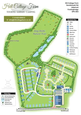
Portrait park map with mixed touring pitches, seasonal rows, ponds and an extensive dog walk.
 Explore the map ↗
United Kingdom
A woodland estate park map combining caravan loops, touring pitches, riverside paths and Bruce’s Cave landmarks.
 Explore the map ↗
United Kingdom
Woodland-framed Barnsoul map with mixed accommodation, shared facilities and paw-marked walking routes.
Features may come from the sample artwork, its key or published park information. Approximate numbers describe the drawing and may cover only part of a park. They are intended to help you compare map examples. Current facilities and booking information should be checked with the park.
TAKE A CLOSER LOOK
View the illustrated map in detail or choose a file to download. These are sample maps; contact the park for current visitor information.


LET’S MAP YOUR PARK
For a map quotation, find your park and draw a rough boundary around it. The area you select helps us work out the design time and price.
Draw your park for a quote ↗Or talk to our map designers
01751 473136