
Tree-lined boundaries
Repeated leafy tree symbols frame much of the perimeter and separate parts of the western accommodation area.
ILLUSTRATED PARK MAP · P167
Hilltop Holiday Park, 60 Loguestown Road, Portrush · United Kingdom
 Enlarge the map ↗
A SENSE OF THE PLACE
Hilltop Holiday Park is located near Portrush and West Strand Beach on Northern Ireland's north coast. Its accommodation includes camping cabins, geo domes and camping spaces.
Toilets, showers and cooking or barbecue facilities support these stays. The cabins provide basic equipment such as a kettle, microwave and fridge, giving visitors an alternative to bringing a tent while retaining a camping-style holiday.
LOOK CLOSER
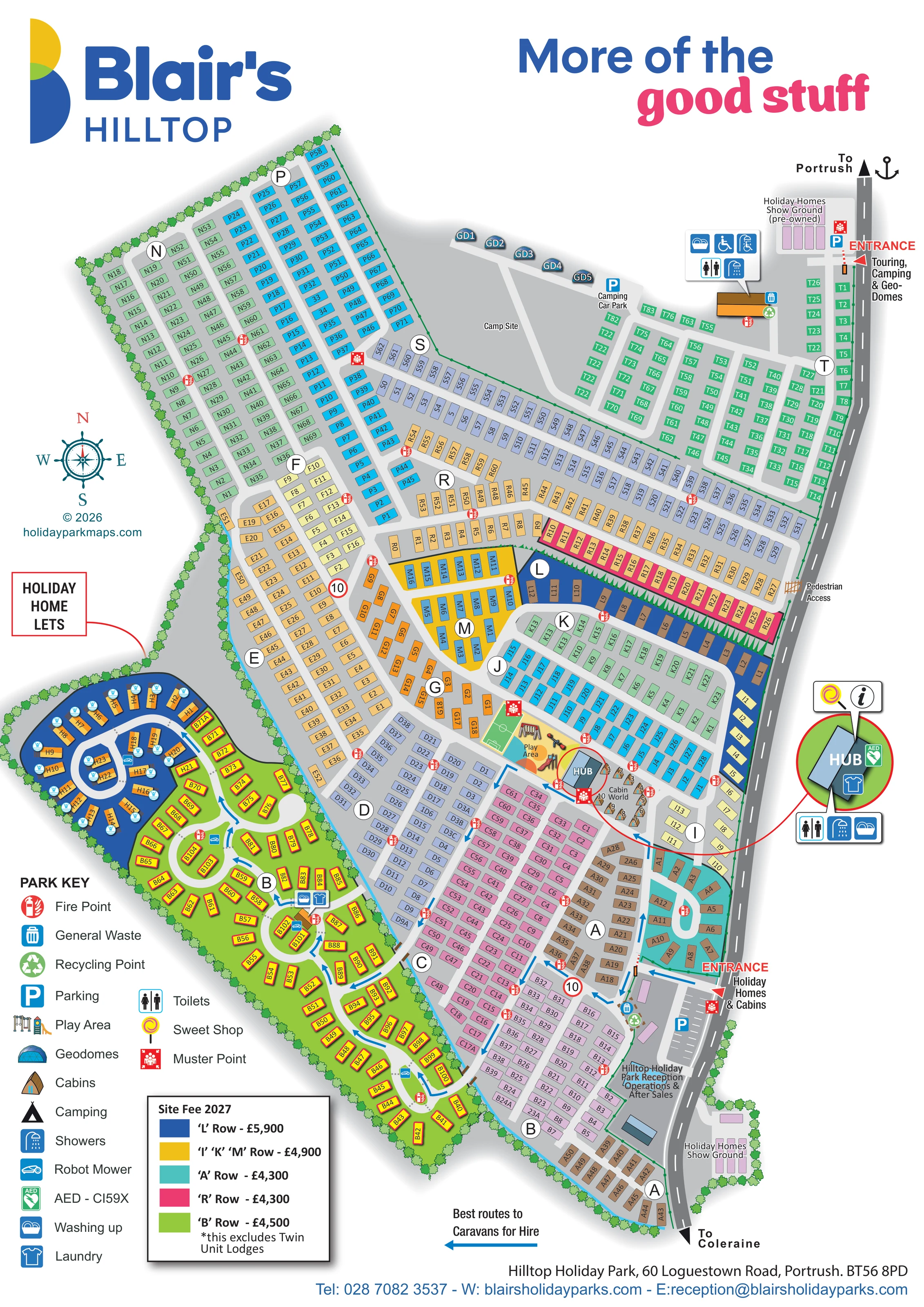
Repeated leafy tree symbols frame much of the perimeter and separate parts of the western accommodation area.
An unpartitioned grey campsite provides a clear visual contrast with the surrounding dense pitch and holiday-home grids.
A labelled building and parking area sit immediately inside the southern holiday-home and cabin entrance.
A prominent illustrated central building is repeated in a circular enlargement, with associated service symbols.
A lollipop symbol identifies the sweet shop at the Hub.
Illustrated play equipment occupies a yellow area immediately beside the Hub, next to a small green marked play court.
A small green rectangular court with white markings is drawn beside the playground; the artwork does not name its sport.
Symbols identify toilet and shower facilities at the Hub and at the northern camping service building.
A labelled building and parking area sit immediately inside the southern holiday-home and cabin entrance.
A prominent illustrated central building is repeated in a circular enlargement, with associated service symbols.
A lollipop symbol identifies the sweet shop at the Hub.
Illustrated play equipment occupies a yellow area immediately beside the Hub, next to a small green marked play court.
A small green rectangular court with white markings is drawn beside the playground; the artwork does not name its sport.
Symbols identify toilet and shower facilities at the Hub and at the northern camping service building.
Wheelchair and accessible-shower symbols appear in the northern service-building callout, without further specification of access provision.
Service symbols mark washing-up and laundry provision at the Hub and in the western loop-road accommodation area; washing-up is also marked at the camping service building.
A green AED symbol is attached to the enlarged Hub illustration.
Grouped waste and recycling symbols appear near the main reception parking area and northern service building, with further waste provision in the western accommodation area.
Repeated red fire-point symbols are distributed through accommodation rows, with larger muster-point symbols at selected entrances and shared areas.
Small blue robot-mower symbols appear within the western loop-road neighbourhood.
Parking is marked beside reception, at the camping car park and beside the northern pre-owned holiday-home show ground.
Two sales display areas are labelled along the external road: a southern holiday-home show ground and a northern pre-owned show ground.
The southern entrance serves holiday homes and cabins; the northern entrance serves touring, camping and geodomes.
A pedestrian access point is labelled partway along the eastern roadside boundary.
Blue directional arrows trace selected internal routes, explained by a separate Best routes to Caravans for Hire key.
A dark-grey road follows the eastern edge, with directions towards Portrush at the top and Coleraine at the bottom.
Repeated leafy tree symbols frame much of the perimeter and separate parts of the western accommodation area.
An unpartitioned grey campsite provides a clear visual contrast with the surrounding dense pitch and holiday-home grids.
READING THE MAP
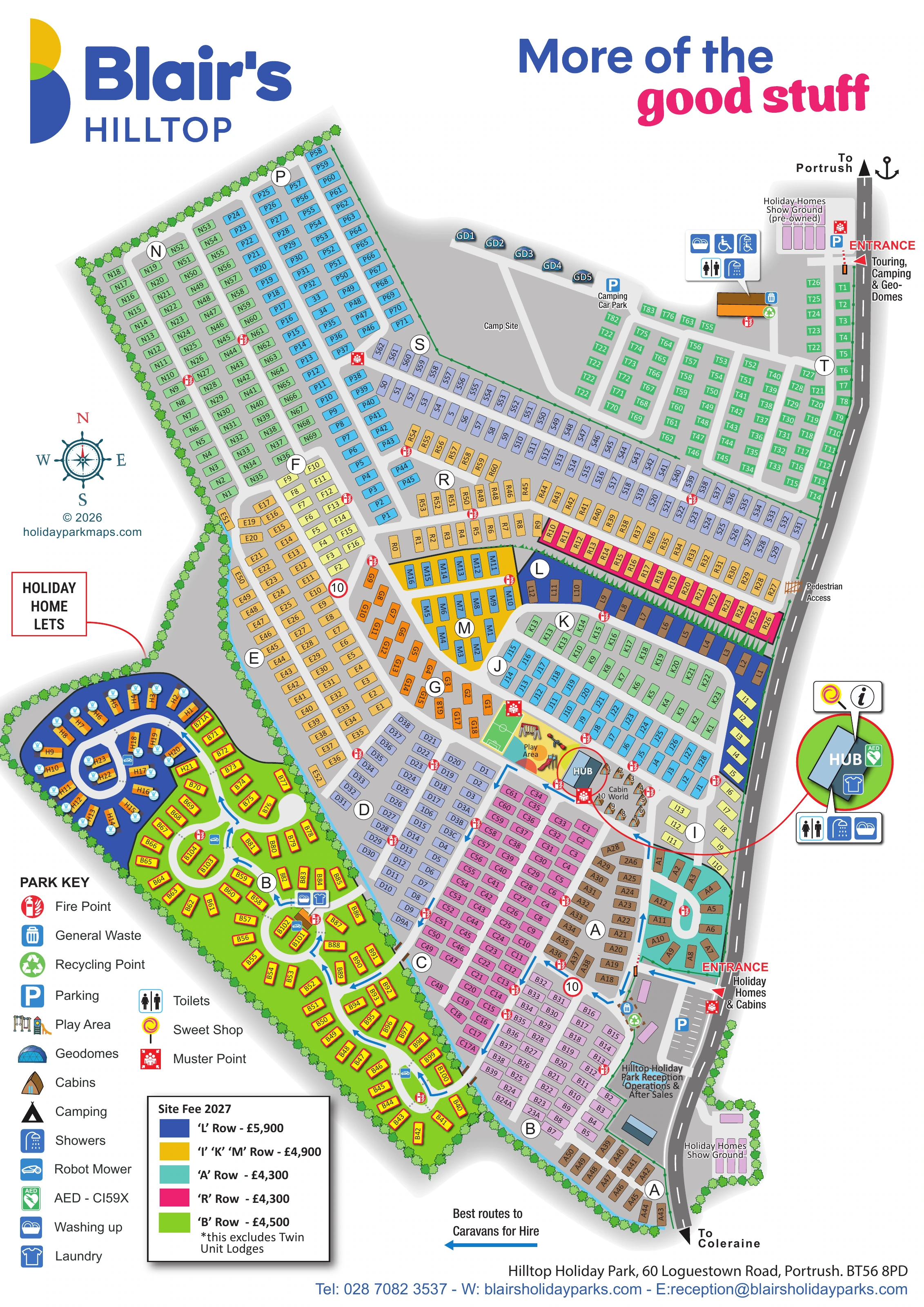
This map of Blair's Hilltop in Portrush brings a large, mixed-accommodation holiday park into one portrait-format plan. Extensive holiday-home neighbourhoods occupy most of the artwork, while touring pitches, an open campsite and a small line of geodomes form a distinct northern area. Cabin World sits closer to the centre, beside the Hub and play area. The result is a map that needs to explain both a substantial network of accommodation rows and several different visitor destinations.
Two clearly labelled entrances separate holiday-home and cabin arrivals from touring, camping and geodome arrivals. Large neighbourhood letters, individual unit references and blue arrows to hire caravans provide successive levels of guidance. Shared facilities are picked out with recognisable symbols, and an enlarged Hub illustration makes this central destination easier to find.
The design combines a practical overhead plan with small illustrated touches: faceted domes, pitched cabins, play equipment and leafy boundary trees. Strong Blair's branding, colourful accommodation areas and a generous park key give the busy plan a clear visual structure without turning it into a scenic bird's-eye illustration.
The single portrait artwork shows an elongated park beside a road labelled towards Portrush at the northern end and Coleraine at the southern end. The holiday-home and cabin entrance leads past reception, operations and after-sales, with a marked car park immediately alongside. A second entrance at the top serves touring, camping and geodomes. Holiday-home show grounds sit beside both ends of the roadside frontage, with the northern display identified as pre-owned.
Across the main park, accommodation is organised into lettered neighbourhoods containing compact, individually labelled rectangles. Most follow parallel access lanes, but the western area uses a succession of loops and curved roads. Blue arrows pick out recommended routes to caravans for hire. Selected neighbourhoods have strongly coloured ground bands, while a long dark-blue strip and a pink-edged row create particularly recognisable landmarks. Tree symbols enclose much of the perimeter, and pedestrian access is labelled on the eastern boundary.
The Hub forms the central amenity focus. Its circular enlargement identifies the sweet shop, AED and laundry, with toilets, showers and washing-up symbols beneath. Nearby are Cabin World, an illustrated playground and a small marked green play court. At the northern end, the open campsite sits between a line of five geodomes, a camping car park and the touring grid. A separate service-building callout includes toilets, showers, washing-up and accessible-facility symbols.
Distributed fire points, muster points, waste and recycling symbols add operational detail. The lower-left park key explains the pictograms, alongside a dated, colour-coded site-fee panel. Large branding occupies the top margin, and contact details finish the footer. The detail views enlarge this same artwork rather than showing additional park sections.
KEEP EXPLORING
Chosen for shared landscapes, accommodation or facilities.
 Explore the map ↗
United Kingdom
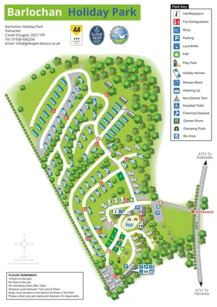
A wooded, mixed-accommodation park plan with winding lanes, a pool, camping areas and a clear facility key.
 Explore the map ↗
United Kingdom
Woodland-framed Barnsoul map with mixed accommodation, shared facilities and paw-marked walking routes.
 Explore the map ↗
United Kingdom
A colour-zoned coastal park map with touring areas, woodland trails, ponds and a leisure club.
Features may come from the sample artwork, its key or published park information. Approximate numbers describe the drawing and may cover only part of a park. They are intended to help you compare map examples. Current facilities and booking information should be checked with the park.
TAKE A CLOSER LOOK
View the illustrated map in detail or choose a file to download. These are sample maps; contact the park for current visitor information.


LET’S MAP YOUR PARK
For a map quotation, find your park and draw a rough boundary around it. The area you select helps us work out the design time and price.
Draw your park for a quote ↗Or talk to our map designers
01751 473136
 hilltopgbmaps.png
 hilltopgbmaps_large.png
 hilltop_large.png