
Tree-lined boundaries
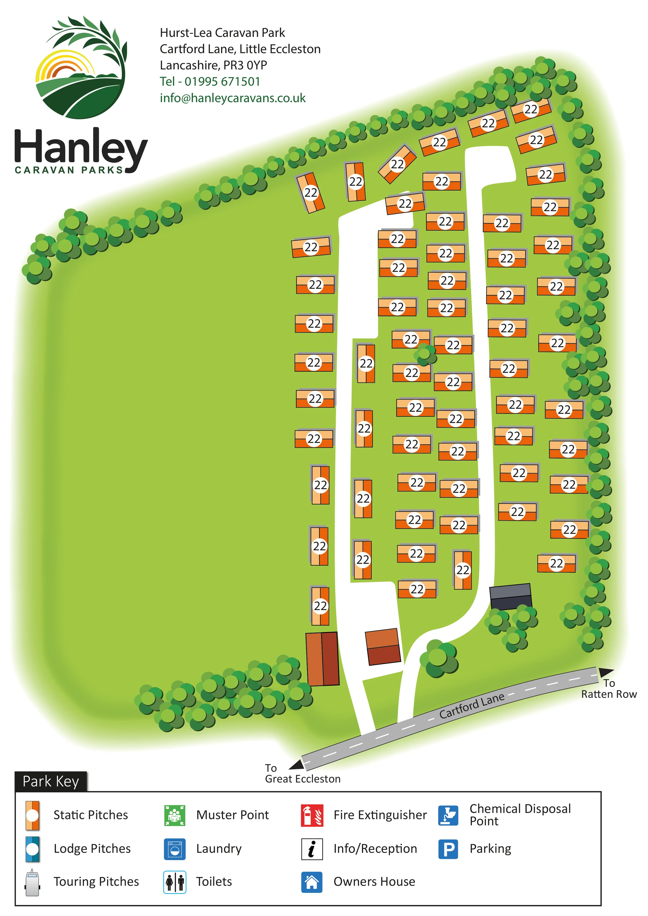
Repeated rounded tree symbols trace much of the sloping upper boundary and right edge, with denser clusters near the lower edge and entrance.
ILLUSTRATED PARK MAP · P503
Hurst-Lea Caravan Park, Cartford Lane, Little Eccleston, Lancashire · United Kingdom
 Enlarge the map ↗
A SENSE OF THE PLACE
Hurst-Lea Caravan Park is based at Cartford Lane, Little Eccleston, Lancashire. This is a rural Little Eccleston location close to the Fylde coast and River Wyre.
Well-behaved dogs are welcome. Each unit is connected to water, electricity and drainage. This is a holiday-home ownership park with static caravans and lodges for sale.
LOOK CLOSER
Repeated rounded tree symbols trace much of the sloping upper boundary and right edge, with denser clusters near the lower edge and entrance.
A substantial uninterrupted green area occupies the left side. It has no named recreational use or accommodation designation.
Named grey road across the lower edge, with dashed white centre markings and connections to the internal white road network.
Black arrows at opposite ends of Cartford Lane provide external orientation.
Two principal white road branches extend upwards from the entrance area, with widening, bends and short spurs serving the accommodation rows.
Two terracotta-roofed building forms stand beside the left access branch, while a dark grey-roofed building sits beside the right branch. Their functions are not labelled on the plan.
Named grey road across the lower edge, with dashed white centre markings and connections to the internal white road network.
Black arrows at opposite ends of Cartford Lane provide external orientation.
Two principal white road branches extend upwards from the entrance area, with widening, bends and short spurs serving the accommodation rows.
Repeated rounded tree symbols trace much of the sloping upper boundary and right edge, with denser clusters near the lower edge and entrance.
A substantial uninterrupted green area occupies the left side. It has no named recreational use or accommodation designation.
Two terracotta-roofed building forms stand beside the left access branch, while a dark grey-roofed building sits beside the right branch. Their functions are not labelled on the plan.
A black information symbol is provided in the key; its location is not identifiable on the main plan.
A blue house pictogram appears in the key, without a corresponding marked location.
Separate toilet and washing-machine pictograms appear in the key. Neither is positioned on the main plan.
The key includes a blue chemical-disposal pictogram, but no location is identifiable within the park drawing.
A blue P symbol is included in the key; the plan does not identify a corresponding parking area.
Red fire-extinguisher and green muster-point symbols are explained in the key, without marked positions on the main plan.
READING THE MAP
This illustrated map of Hurst-Lea Caravan Park presents a tree-lined holiday-home site at Little Eccleston in Lancashire. Cartford Lane anchors the lower edge, with arrows towards Great Eccleston and Ratten Row giving the drawing a clear local reference. Inside the park, broad white access roads lead through rows of orange static-caravan symbols, while a large open green area gives the left-hand side a notably spacious appearance.
The portrait layout combines a simple overhead plan with prominent Hanley Caravan Parks branding, park contact details and a full-width key. Rounded trees, contrasting roof colours and white pitch-label discs make the site's main components visually distinct without relying on detailed architectural rendering.
For a sample gallery, this is a useful example of a compact caravan-park plan that gives equal attention to accommodation layout, entrance orientation and operator identity. Its strongest visual characteristic is the contrast between the ordered pitch rows and the softer, tree-framed green space around them.
The map uses a predominantly overhead view to show an elongated park footprint with an angled upper boundary. Static-caravan symbols occupy the right-hand portion, arranged in several narrow rows beside two principal white access branches. Most units lie horizontally, while others rotate to suit the roads or the upper perimeter. Their orange and peach colouring, dark outlines and white circular labels establish a consistent visual language for the accommodation.
Cartford Lane runs diagonally across the foot of the drawing. Its grey surface and dashed centre markings distinguish it from the unmarked internal roads, and arrows point towards Great Eccleston and Ratten Row. Near the entrance are two terracotta-roofed buildings and a separate dark-roofed structure; the drawing does not label their functions. The road branches widen and curve as they enter the accommodation area, making the relationship between arrival and the pitch rows easy to follow.
A broad green area fills the left side, without a named activity or pitch designation. Layered circular trees frame much of the upper and right-hand boundaries, with larger clusters near the lower edge and entrance. A soft green fade separates the park from the white page.
The footer key explains static, lodge and touring pitch symbols, together with reception, the owner's house, toilets, laundry, parking, chemical disposal, fire extinguishers and a muster point. These facility pictograms are not positioned on the main plan. The artwork is a single portrait page; the accompanying detail views enlarge the same key rather than showing additional park sections.
KEEP EXPLORING
Chosen for shared landscapes, accommodation or facilities.
 Explore the map ↗
United Kingdom
Woodland-framed Barnsoul map with mixed accommodation, shared facilities and paw-marked walking routes.
 Explore the map ↗
United Kingdom
Colour-coded park map with numbered holiday-home areas, touring pitches, camping and an illustrated leisure hub.
 Explore the map ↗
United Kingdom
A wooded, streamside park map with a linked farm, café, touring and cottage area.
Features may come from the sample artwork, its key or published park information. Approximate numbers describe the drawing and may cover only part of a park. They are intended to help you compare map examples. Current facilities and booking information should be checked with the park.
LET’S MAP YOUR PARK
For a map quotation, find your park and draw a rough boundary around it. The area you select helps us work out the design time and price.
Draw your park for a quote ↗Or talk to our map designers
01751 473136