
Tree-lined boundaries and planted divisions
Dense chains of small trees define the perimeter and divide pitch groups, with larger tree canopies scattered around buildings and open spaces.
ILLUSTRATED PARK MAP · P510
40 New Road, North Runcton, King's Lynn · United Kingdom
 Enlarge the map ↗
A SENSE OF THE PLACE
King's Lynn Caravan and Camping Park is set in mature parkland at North Runcton. Touring pitches and tent spaces sit alongside camping pods and holiday lodges.
Seasonal pitches and a separate rally area provide options for repeat visits and groups. The park welcomes families and dogs, with King's Lynn and the wider Norfolk countryside available to explore from the site.
LOOK CLOSER
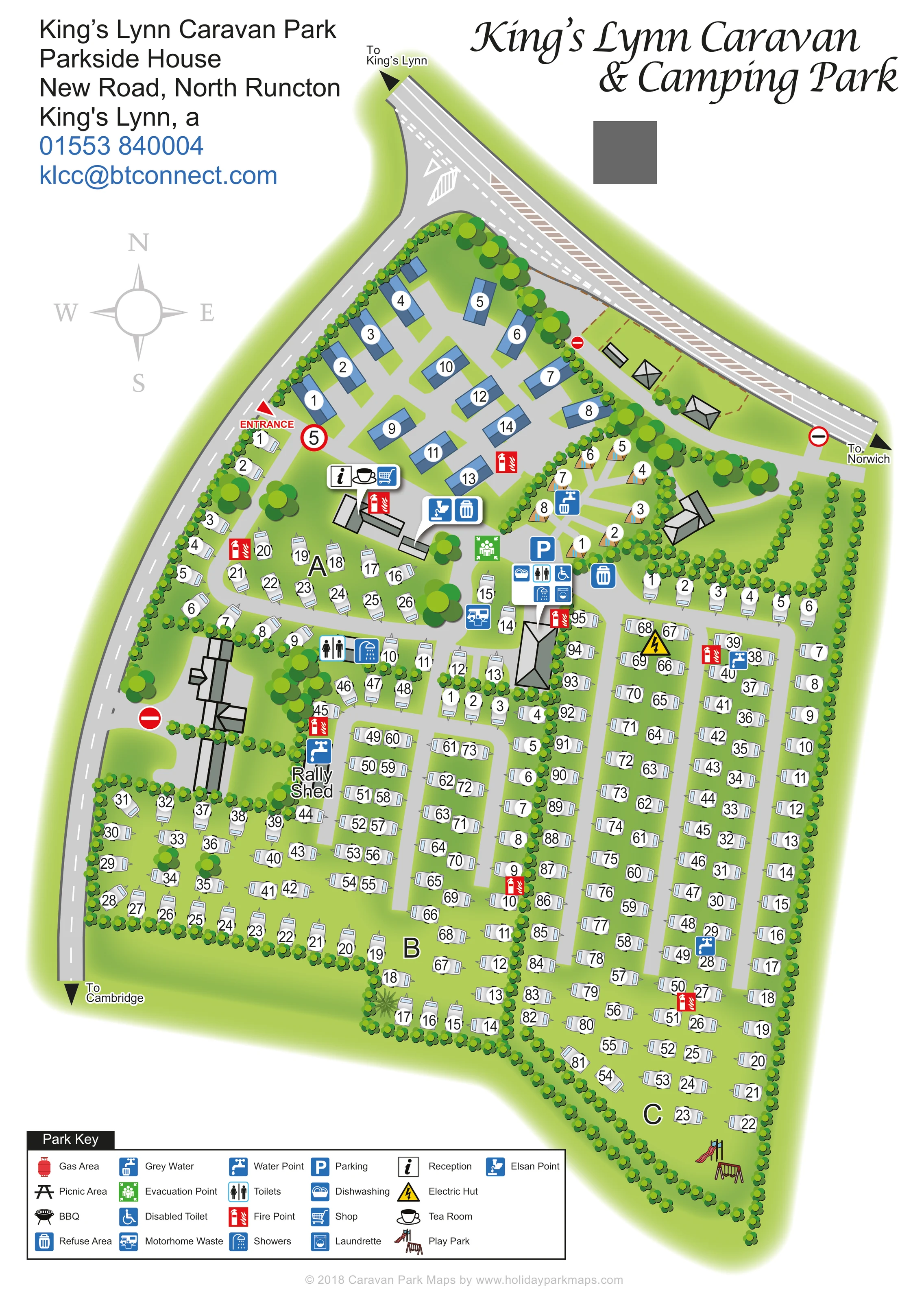
Dense chains of small trees define the perimeter and divide pitch groups, with larger tree canopies scattered around buildings and open spaces.
Green ground surrounds the accommodation throughout, with more open camping space towards the northern and eastern edges.
An information symbol marks reception near the entrance, beside the shop and tea room symbols.
A shopping trolley symbol identifies the shop within the arrival-side building group.
A cup-and-saucer symbol places the tea room beside reception and the shop.
A blue parking symbol marks the central area between the pod cluster and the main facilities.
Toilet and shower symbols identify the central service block and another washroom location towards the western touring area. A disabled toilet symbol appears at the central block.
A washing-machine symbol identifies a laundrette at the central facilities cluster.
An information symbol marks reception near the entrance, beside the shop and tea room symbols.
A shopping trolley symbol identifies the shop within the arrival-side building group.
A cup-and-saucer symbol places the tea room beside reception and the shop.
A blue parking symbol marks the central area between the pod cluster and the main facilities.
Toilet and shower symbols identify the central service block and another washroom location towards the western touring area. A disabled toilet symbol appears at the central block.
A washing-machine symbol identifies a laundrette at the central facilities cluster.
A dishwashing symbol is grouped with the central toilets, showers and laundrette.
Water taps are distributed among the touring sections; refuse symbols appear beside central facilities and near the pod area.
Distinct symbols locate an Elsan point and refuse area near the arrival buildings, grey-water disposal near the pods, and motorhome waste beside the central service area.
A slide and swing illustration identifies a play area at the southern tip of section C.
A labelled building stands among the western touring pitches near the division between the upper and lower accommodation areas.
A yellow lightning-bolt warning symbol marks an electric hut in the upper part of section C.
Red fire-point symbols are distributed through the accommodation areas. A green evacuation-point symbol appears close to the central arrival and service area.
A gas-cylinder symbol is explained in the key, but a corresponding location is not clearly identifiable on the plan.
A picnic-table symbol appears in the key without a clearly identifiable placement on the plan.
A barbecue symbol is included in the key; its location is not clearly shown in the main drawing.
Dense chains of small trees define the perimeter and divide pitch groups, with larger tree canopies scattered around buildings and open spaces.
Green ground surrounds the accommodation throughout, with more open camping space towards the northern and eastern edges.
A red entrance arrow identifies access from the western roadside, leading towards reception and the internal accommodation lanes.
Black directional arrows connect the illustrated surrounding roads with King's Lynn to the north, Norwich to the east and Cambridge to the south-west.
Light-grey internal lanes connect the arrival hub, lodge and pod groups, and touring rows. The plan also includes a 5 speed sign and no-entry symbols, without spelling out a complete circulation rule.
The park information mentions a separate rally area. The artwork labels a Rally Shed but does not clearly delineate a rally-area boundary.
READING THE MAP
This illustrated map of King’s Lynn Caravan & Camping Park brings together a varied accommodation layout in a tree-lined setting at North Runcton, Norfolk. The long, tapering plan combines extensive touring areas with a smaller group of blue-roofed lodges, camping pods and grassy camping space near the northern boundary.
The western entrance leads towards a compact reception, shop and tea room hub. From here, pale-grey lanes connect the accommodation groups and central facilities before continuing through the larger touring sections. Bold A, B and C labels make the main pitch areas easy to distinguish, while individual numbers support more precise orientation.
The artwork also shows the practical details that matter on arrival: parking, washrooms, a laundrette, dishwashing, water points and waste-disposal facilities. A play park occupies the southern end of the site, and tree-lined divisions help explain its internal structure. Directions towards King’s Lynn, Norwich and Cambridge place the park within its surrounding road network, without turning the drawing into a wider regional map.
The portrait artwork follows the park’s elongated outline, with public roads framing its western and northern sides. Junction markings and destination arrows provide a recognisable approach context, while a red entrance marker directs attention to the western access point. A compass rose sits in the open margin beside the plan.
Accommodation is differentiated through its illustration. The northern lodge group uses blue roof panels and circular number labels. Nearby pods have small tan curved roofs, while tent drawings indicate camping areas along the northern and eastern edges. Most of the remaining site is occupied by white caravan symbols, arranged in a combination of perimeter pitches and paired rows. Large A, B and C letters organise these touring areas without obscuring the finer pitch-level information.
Reception, the shop and tea room are grouped close to the entrance. Farther into the site, a parking symbol and service cluster identify toilets, showers, a disabled toilet, dishwashing and the laundrette. Another washroom location appears towards the western side. Water, refuse and waste-disposal symbols are distributed around the accommodation, with motorhome waste separately identified near the central facilities. The Rally Shed is named among the western pitches, and a slide-and-swing illustration marks the play park at the southern tip.
Repeated green tree canopies form boundaries and internal divisions, helping readers follow the long rows and separate accommodation groups. The lower-left key explains the facility symbols, including several entries without clearly visible locations on the main plan. The accompanying detail images enlarge this same key and the southern play-area edge; they are not additional maps or accommodation areas.
KEEP EXPLORING
Chosen for shared landscapes, accommodation or facilities.
 Explore the map ↗
United Kingdom
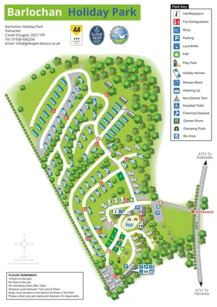
A wooded, mixed-accommodation park plan with winding lanes, a pool, camping areas and a clear facility key.
 Explore the map ↗
United Kingdom
Woodland-framed Barnsoul map with mixed accommodation, shared facilities and paw-marked walking routes.
 Explore the map ↗
United Kingdom
Woodland park map with mixed pitches, bell tents, lodges and a fishing lake.
Features may come from the sample artwork, its key or published park information. Approximate numbers describe the drawing and may cover only part of a park. They are intended to help you compare map examples. Current facilities and booking information should be checked with the park.
TAKE A CLOSER LOOK
View the illustrated map in detail or choose a file to download. These are sample maps; contact the park for current visitor information.


LET’S MAP YOUR PARK
For a map quotation, find your park and draw a rough boundary around it. The area you select helps us work out the design time and price.
Draw your park for a quote ↗Or talk to our map designers
01751 473136