
Kite Field
A named recreation field with a simple white kite drawing lies above the multi-sports pitch.
ILLUSTRATED PARK MAP · P516
Exeter Road, Dawlish, Devon · United Kingdom
 Enlarge the map ↗
A SENSE OF THE PLACE
Lady's Mile Holiday Park offers a range of accommodation and family activities at Dawlish in South Devon. Caravan and lodge options include selected pet-friendly properties.
Indoor and outdoor swimming pools form a major part of the park's leisure facilities. Some accommodation has private hot tubs, and a dog wash supports visitors travelling with pets. The map helps explain the relationship between accommodation and activity areas.
LOOK CLOSER
A named recreation field with a simple white kite drawing lies above the multi-sports pitch.
The Meadow, Main Field, Top Meadow, Copps Field and Beachway divide the open grounds into recognisable destination areas.
Dense illustrated trees define the perimeter, separate accommodation areas and form a broad wooded wedge at the southern end.
Number 2 in the facilities inset identifies reception at the entrance-side complex.
Number 1 locates the restaurant and bar within the main leisure building.
Number 3 identifies a separate bar within the enlarged facilities cluster.
Number 7 identifies indoor swimming in the main building.
Blue pool shapes, a curved slide-like feature and rows of red-and-white loungers are drawn beside the main building, particularly clearly in the inset.
Number 2 in the facilities inset identifies reception at the entrance-side complex.
Number 1 locates the restaurant and bar within the main leisure building.
Number 3 identifies a separate bar within the enlarged facilities cluster.
Number 7 identifies indoor swimming in the main building.
Blue pool shapes, a curved slide-like feature and rows of red-and-white loungers are drawn beside the main building, particularly clearly in the inset.
Number 4 identifies the launderette in the smaller building alongside the pool area.
Numbers 5 and 8 distinguish the shop and Kids Shop within the entrance-side facilities complex.
Numbers 9 and 10 locate two food-service points beside the Piano Bar in the inset.
Toilet symbols mark several facilities across the grounds. The inset also locates the specifically named Bottom Toilet Block as number 6.
Repeated blue tap symbols are distributed along the field lanes and accommodation routes.
Blue P symbols identify parking around the entrance facilities and within the north-central accommodation loop.
A slide and swing illustration marks the playground between the western accommodation groups and the central fields.
A white-lined sports court occupies a green space south of Kite Field and inside the Warren Road boundary.
A labelled green area with paw-print symbols sits between the northern accommodation loop and Kite Field.
A named recreation field with a simple white kite drawing lies above the multi-sports pitch.
A grey storage area is shown immediately beyond the entrance at the top of the plan.
The south-eastern seasonal field contains a Solar Array label and three stylised panel-and-sun symbols.
Red assembly-point signs recur near the leisure complex, accommodation groups and toilet buildings.
A blue bin symbol is included in the legend; specific bin locations are not clearly identifiable in the overview.
The Meadow, Main Field, Top Meadow, Copps Field and Beachway divide the open grounds into recognisable destination areas.
Dense illustrated trees define the perimeter, separate accommodation areas and form a broad wooded wedge at the southern end.
An oversized green arrow identifies arrival from Week Lane beside caravan storage and the main facilities.
The A379 Exeter Road forms the western edge, Week Lane the northern edge, and curving Warren Road the eastern and southern boundary.
Blue arrows point towards the beach from the north-east and south of the plan. A separate black arrow identifies a footpath to the beach beside Beachway.
Red arrows on the A379 orient visitors towards Dawlish at the southern end and Exeter at the northern end.
White routes connect the fields, form loops around numbered accommodation and branch into the hard-standing and Beachway areas.
READING THE MAP
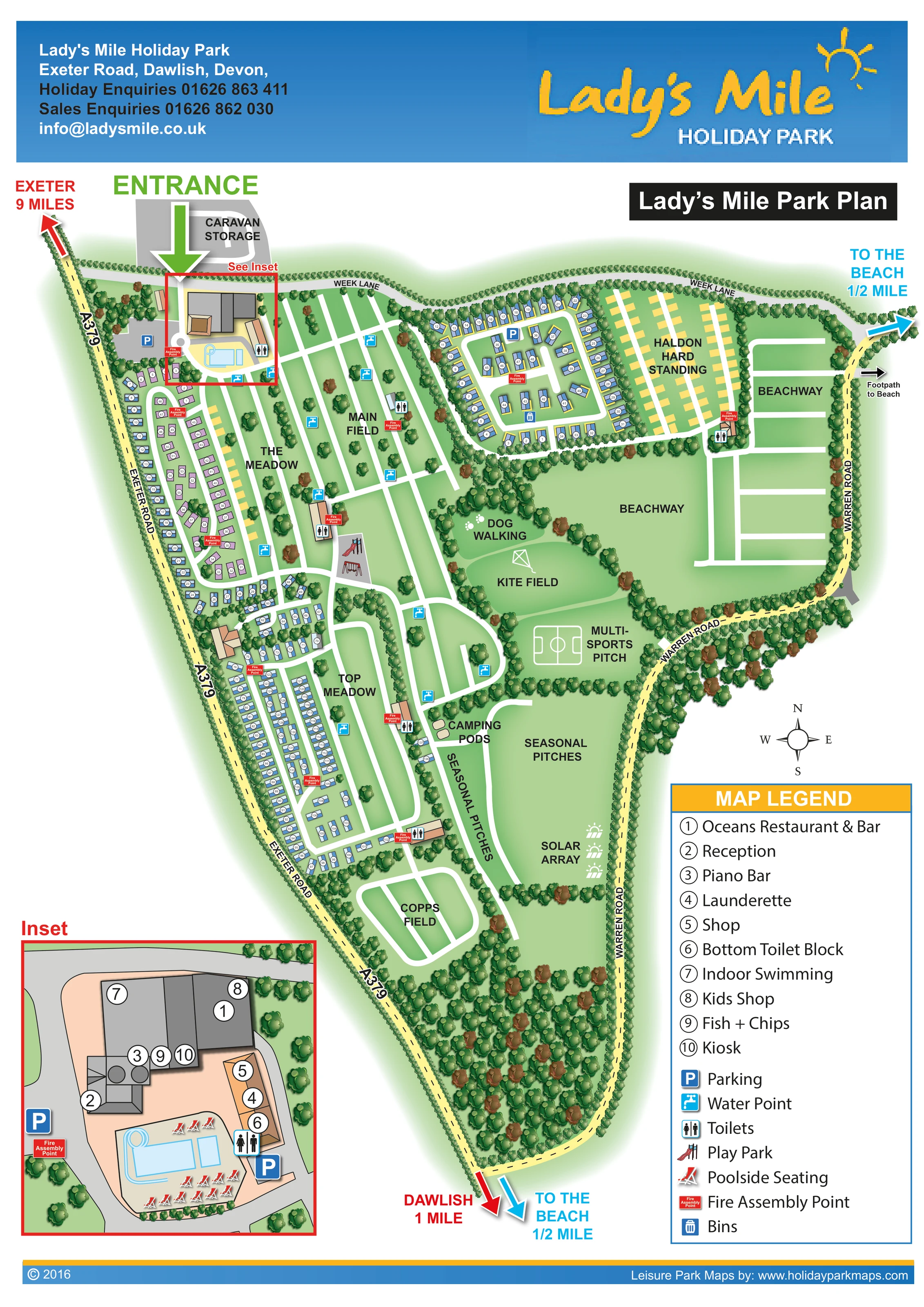
This illustrated map of Lady’s Mile Holiday Park in Dawlish, Devon, brings a large, varied site together on a single portrait page. The grounds stretch between Exeter Road, Week Lane and Warren Road, with numbered accommodation groups along the western side, open fields through the centre and additional areas towards Beachway. Tree belts give each section a clear visual boundary without obscuring the routes between them.
The entrance is deliberately prominent: a large green arrow points towards the main leisure complex, where a red locator frame connects to an enlarged inset below. This close-up explains the relationship between reception, indoor swimming, the outdoor pool, shops, bars and food outlets. Elsewhere, the map shows camping pods, seasonal pitches, Haldon Hard Standing and named fields, alongside a play park, dog walking area, Kite Field and a multi-sports pitch.
For a designer’s gallery, the sample demonstrates how an accommodation-heavy park can be presented with both broad orientation and local detail. A substantial legend, repeated service symbols and beach-direction arrows help the illustration function as a practical visitor guide rather than simply a decorative overview.
The main plan follows the park’s long, tapering outline, bounded by the A379 Exeter Road to the west, Week Lane across the top and Warren Road around the eastern and southern edges. White internal lanes cut through green fields and form loops around the numbered accommodation groups. Rows along the western boundary contrast with a compact north-central loop, the parallel lanes of Haldon Hard Standing and the more open layout of Beachway.
Large labels identify The Meadow, Main Field, Top Meadow and Copps Field. Near the south-eastern side, two rounded pod symbols mark Camping Pods, while adjoining areas are labelled Seasonal Pitches. A solar array is indicated within this part of the site. Between the accommodation zones, the dog walking area, Kite Field and a white-lined multi-sports pitch create a distinct recreation sequence. A small illustrated playground sits closer to the central routes.
The entrance-side complex receives a second level of detail in the red-bordered inset. Numbered circles locate Oceans Restaurant & Bar, reception, the Piano Bar, launderette, shop, Bottom Toilet Block, indoor swimming, Kids Shop, Fish + Chips and Kiosk. Outdoor pool shapes and rows of loungers make the adjoining leisure space immediately recognisable. Parking, water points, toilets and fire assembly points are marked elsewhere with repeated symbols; bins are included in the legend.
A compass rose and external destination arrows complete the orientation system, including a separately labelled footpath to the beach. The accompanying enlarged view shows the same artwork’s legend and south-eastern edge more closely; it is not an additional park section. Across the page, shaded tree crowns, soft green grass and bold route labels balance landscape character with practical navigation.
KEEP EXPLORING
Chosen for shared landscapes, accommodation or facilities.
 Explore the map ↗
United Kingdom
Trevornick’s colour-coded park map, with mixed accommodation, fishing ponds, golf and wooded trails.
 Explore the map ↗
United Kingdom
A colour-zoned coastal park map with touring areas, woodland trails, ponds and a leisure club.
 Explore the map ↗
United Kingdom
Coastal park plan with colour-coded pitches, named neighbourhoods and a Morecambe Bay walking route.
Features may come from the sample artwork, its key or published park information. Approximate numbers describe the drawing and may cover only part of a park. They are intended to help you compare map examples. Current facilities and booking information should be checked with the park.
TAKE A CLOSER LOOK
View the illustrated map in detail or choose a file to download. These are sample maps; contact the park for current visitor information.


LET’S MAP YOUR PARK
For a map quotation, find your park and draw a rough boundary around it. The area you select helps us work out the design time and price.
Draw your park for a quote ↗Or talk to our map designers
01751 473136