
Coarse fishing lake
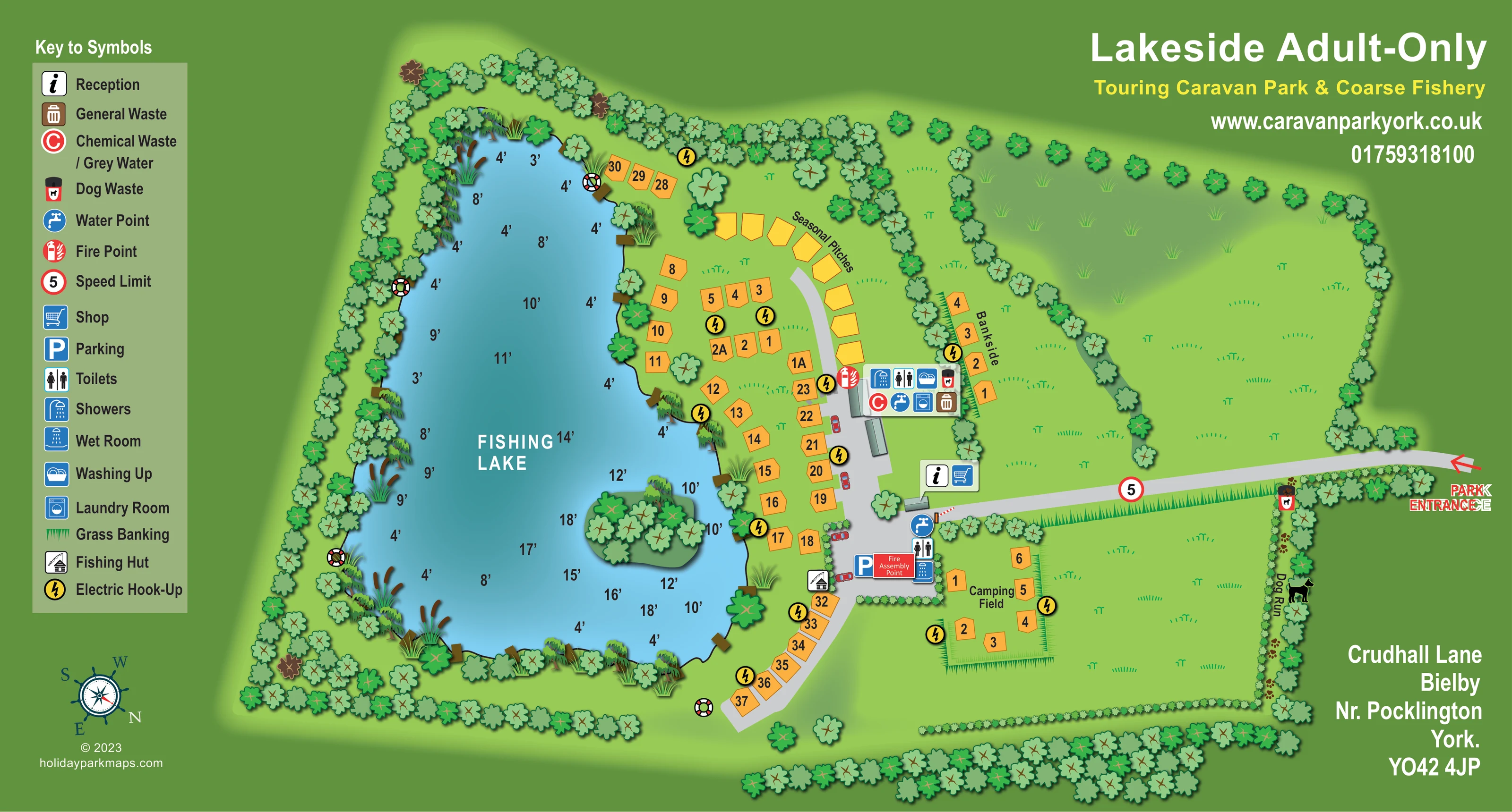
The dominant feature occupies the left side of the plan and is labelled Fishing Lake, with numerous water-depth annotations in feet.
ILLUSTRATED PARK MAP · P184
Crudhall Lane, Bielby, Nr Pocklington, York · United Kingdom
 Enlarge the map ↗
A SENSE OF THE PLACE
Lakeside Touring Caravan Park and Coarse Fishery is located on Crudhall Lane at Bielby near Pocklington. Touring stays and coarse fishing are the site's principal themes.
The map gives an overview of the grounds and their waterside layout. It provides a useful starting point for visitors planning a caravan stay or fishing visit in this part of East Yorkshire.
LOOK CLOSER
The dominant feature occupies the left side of the plan and is labelled Fishing Lake, with numerous water-depth annotations in feet.
A small tree-covered island, reed clumps, marginal trees and short brown bankside platforms give the lake a detailed outline.
Repeated green triangular strokes identify banks along the entrance drive, around parts of the camping area and beside the lake.
Dense tree belts frame the park, while broad grass areas fill the right side and a diagonal tree line separates the upper field from the Bankside pitches.
A fishing-hut symbol is positioned beside the lower lakeside pitches and the parking area.
Adjacent reception and shop symbols identify a small building near the junction of the entrance drive and the internal pitch road.
Toilet and shower symbols appear at the central service building; another toilet and wet-room grouping is shown beside the lower parking area.
Laundry and washing-up symbols are grouped with the main central service building.
The dominant feature occupies the left side of the plan and is labelled Fishing Lake, with numerous water-depth annotations in feet.
A small tree-covered island, reed clumps, marginal trees and short brown bankside platforms give the lake a detailed outline.
A fishing-hut symbol is positioned beside the lower lakeside pitches and the parking area.
Adjacent reception and shop symbols identify a small building near the junction of the entrance drive and the internal pitch road.
Toilet and shower symbols appear at the central service building; another toilet and wet-room grouping is shown beside the lower parking area.
Laundry and washing-up symbols are grouped with the main central service building.
The plan locates water points, chemical waste/grey-water disposal and general waste around the service areas, with dog-waste symbols at the central block and along the dog-run boundary.
Yellow lightning-bolt circles are distributed through the touring, Bankside and camping pitch groups.
A blue parking symbol marks the lower end of the central arrival and service area.
A narrow, tree-lined strip down the right-hand boundary is labelled Dog Run and illustrated with a dog silhouette.
Fire-point markings appear around the central pitch road and service building. A red Fire Assembly Point label sits beside parking.
Red-and-white lifebuoy illustrations are placed at several positions around the lake and near its lower approach.
Repeated green triangular strokes identify banks along the entrance drive, around parts of the camping area and beside the lake.
Dense tree belts frame the park, while broad grass areas fill the right side and a diagonal tree line separates the upper field from the Bankside pitches.
A red entrance arrow at the far right leads onto a grey drive towards reception and the service hub. A circular speed-limit symbol marked 5 appears on this approach.
Seasonal Pitches, Bankside and Camping Field labels distinguish the main accommodation groups alongside individual pitch numbers.
READING THE MAP
This illustrated map of Lakeside Touring Caravan Park & Coarse Fishery brings a fishing-led holiday site into a single, readable landscape plan. Located at Bielby near Pocklington in East Yorkshire, the park is presented around its most distinctive feature: a large, irregularly shaped fishing lake with a wooded island, planted margins and depth markings.
The map shows touring pitches arranged mainly along the lake's right bank, with a curved seasonal section, a separate Bankside row and a small camping field. A grey entrance drive leads from the right-hand edge to reception, the shop and a compact cluster of visitor facilities. Numbered orange pitch markers make the accommodation easy to distinguish from the green grounds and blue water.
A full-height symbol key supports practical wayfinding without crowding the landscape with long labels. Toilets, washing facilities, electric hook-ups, waste points, parking and the fishing hut are all located through clear pictograms. The result is a sample particularly relevant to smaller touring parks where waterside recreation and straightforward arrival information need equal emphasis.
The single landscape plan is built around a strong left-to-right division. A tall symbol key occupies the left margin, the fishing lake fills much of the central-left area, and the entrance, accommodation and service buildings occupy the middle and right. The park name, contact details and address use the remaining green space around the illustrated grounds.
The lake is more than a decorative backdrop. Its blue-to-teal surface carries depth figures in feet, while reeds, small bankside platforms, lifebuoy illustrations and a wooded island give visitors identifiable features around the water. Dense tree belts enclose much of the site, with a diagonal planted boundary separating the upper open field from the Bankside pitches.
Orange pitch shapes follow the lake's right shore and continue around the lower bend of the internal road. A curved row towards the top is labelled Seasonal Pitches. Bankside forms a short separate group beside the main service building, while the Camping Field sits below the entrance drive. Yellow electric hook-up circles appear throughout these accommodation areas.
The entrance is marked by a red arrow at the far right. Its grey approach passes a speed-limit symbol before reaching reception and the shop. Nearby icon clusters identify toilets, showers, washing up, laundry, water, waste disposal and fire provision. Further down, parking sits beside a fire assembly point, another washroom grouping and the fishing hut. A narrow dog run follows the right-hand boundary.
The artwork combines overhead planning with softly shaded trees and small building forms. Black pitch numbers, white lake lettering and colour-coded symbols provide a clear functional layer over the illustrated landscape.
KEEP EXPLORING
Chosen for shared landscapes, accommodation or facilities.
 Explore the map ↗
United Kingdom
Ashby Park map with seven fishing lakes, colour-coded accommodation and illustrated wooded shorelines.
 Explore the map ↗
United Kingdom
Woodland park map with mixed pitches, bell tents, lodges and a fishing lake.
 Explore the map ↗
United Kingdom
Illustrated caravan park plan with woodland and riverside walks, fishing pools and wildlife panels.
Features may come from the sample artwork, its key or published park information. Approximate numbers describe the drawing and may cover only part of a park. They are intended to help you compare map examples. Current facilities and booking information should be checked with the park.
LET’S MAP YOUR PARK
For a map quotation, find your park and draw a rough boundary around it. The area you select helps us work out the design time and price.
Draw your park for a quote ↗Or talk to our map designers
01751 473136