
Llynfi River
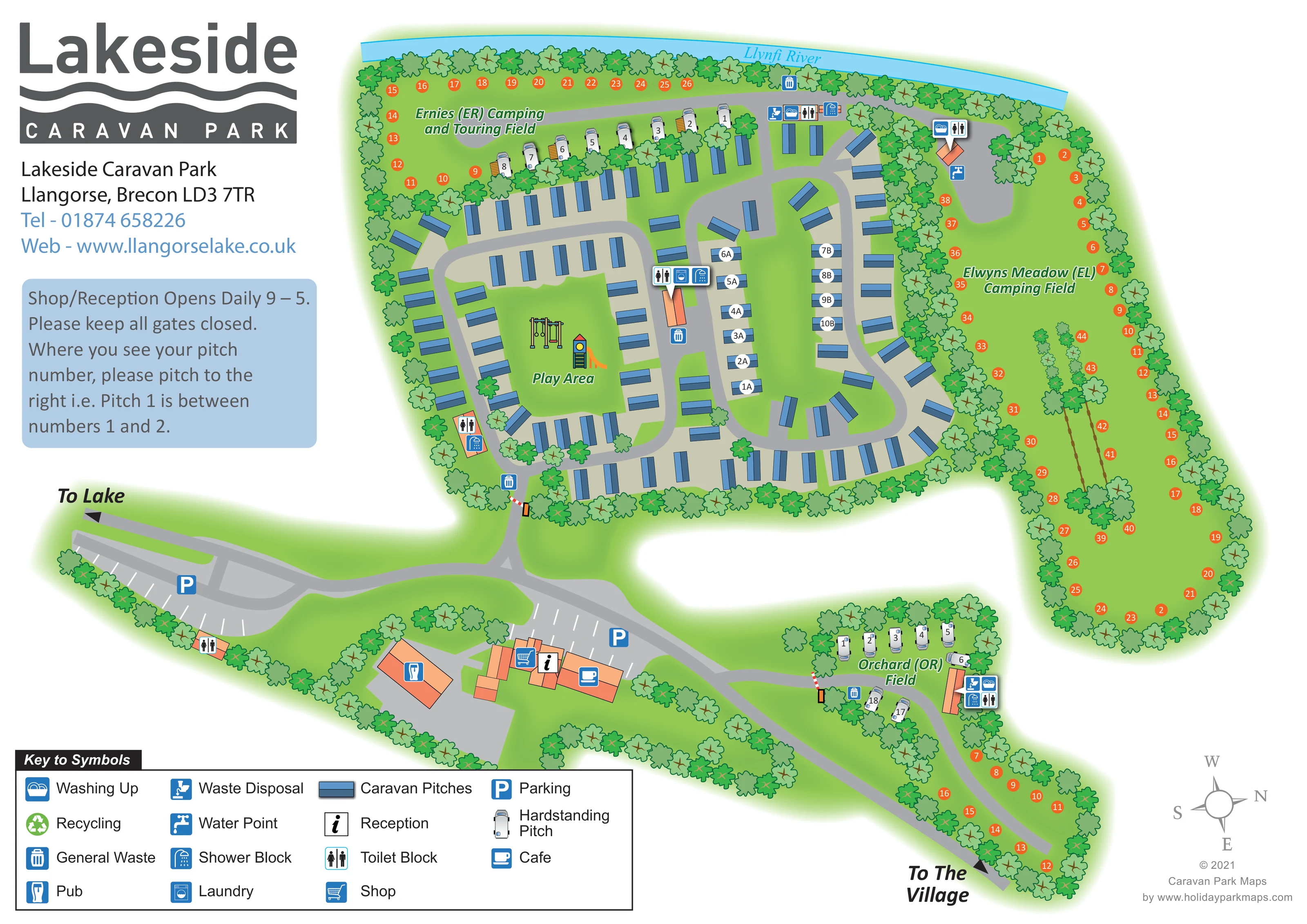
A labelled cyan river strip follows the upper edge of the artwork behind a continuous tree belt.
ILLUSTRATED PARK MAP · P518
Llangorse Lake, Brecon, Powys · United Kingdom
 Enlarge the map ↗
A SENSE OF THE PLACE
Lakeside Caravan & Camping Park is based at Llangorse Lake, Brecon, Powys. The park is beside Llangorse Lake in the Bannau Brycheiniog and Black Mountains area. The park offers camping and touring pitches plus holiday-caravan hire and sales.
The map brings the site layout and its access routes together in one view, providing a reference for understanding the arrangement of the grounds.
LOOK CLOSER
A labelled cyan river strip follows the upper edge of the artwork behind a continuous tree belt.
Dense stylised tree boundaries separate the accommodation areas, with broad grass interiors and a smaller tree-lined division within Elwyns Meadow.
An information symbol marks reception within the building group beside the main parking and approach road.
A shopping-trolley symbol identifies the shop in the arrival-side building group.
A cup symbol marks a café beside reception and the main parking area.
A separate orange building near the arrival facilities carries the pub symbol.
A labelled grassy enclosure within the central caravan loops contains illustrated swings and a slide.
Repeated toilet and shower symbols identify service buildings within the main caravan area and beside the camping and touring fields. A further toilet symbol appears by the lake-side parking.
An information symbol marks reception within the building group beside the main parking and approach road.
A shopping-trolley symbol identifies the shop in the arrival-side building group.
A cup symbol marks a café beside reception and the main parking area.
A separate orange building near the arrival facilities carries the pub symbol.
A labelled grassy enclosure within the central caravan loops contains illustrated swings and a slide.
Repeated toilet and shower symbols identify service buildings within the main caravan area and beside the camping and touring fields. A further toilet symbol appears by the lake-side parking.
Washing-machine symbols appear at service clusters in the main area, beside Ernies and in Orchard Field.
Dishwashing symbols mark facilities beside Ernies, Elwyns Meadow and Orchard Field.
A tap symbol marks a water point near the service building at the upper end of Elwyns Meadow.
Waste-disposal symbols appear at the service clusters beside Ernies and Orchard Field.
Bin symbols are distributed around the main caravan area and near the touring fields and entrance barriers.
A green recycling symbol is included in the key; a corresponding location is not clearly identifiable on the plan.
Two marked parking areas follow the approach road: one beside the arrival buildings and another towards the lake.
A labelled cyan river strip follows the upper edge of the artwork behind a continuous tree belt.
Dense stylised tree boundaries separate the accommodation areas, with broad grass interiors and a smaller tree-lined division within Elwyns Meadow.
A 'To Lake' arrow points beyond the parking area on the left. The lake itself is not illustrated.
A 'To The Village' arrow continues from the lower end of Orchard Field.
Grey approach roads branch into looping caravan lanes and the Orchard route. Red-and-white barrier illustrations mark access to the main caravan area and Orchard Field.
READING THE MAP
This illustrated map of Lakeside Caravan Park at Llangorse, near Brecon, brings together a varied caravan, camping and touring layout beside Llangorse Lake. The Llynfi River forms a blue ribbon along the upper boundary, while dense tree belts give the individual accommodation areas a clear shape. The lake is signposted beyond the left-hand edge rather than drawn into the plan.
At the centre, rows of blue caravan symbols follow curving roads around a grassy play area. Three named fields broaden the layout: Ernies Camping and Touring Field above the caravan area, Elwyns Meadow to the right, and Orchard Field extending towards the village below. Distinct symbols help visitors distinguish caravan pitches, illustrated hardstandings and grass-pitch markers.
The arrival-side buildings, parking and distributed service blocks are brought into the same view, with pictograms for reception, the shop, café, pub and practical facilities. Large Lakeside branding, a spacious symbol key and a compact visitor-information panel make this a useful example of a mixed-accommodation park map with several separate fields and connecting routes.
The artwork uses a top-down layout with the main caravan area occupying the centre and upper-left portion of the grounds. Blue rectangular caravan symbols sit along nested grey road loops, with several white pitch labels providing local references. A central green enclosure contains a labelled play area illustrated with swings and a slide. Service buildings interrupt the caravan rows at useful landmarks, carrying grouped toilet, shower and laundry symbols.
Across the upper boundary, the labelled Llynfi River runs behind a belt of trees. Immediately below it, Ernies (ER) Camping and Touring Field combines illustrated white caravans on hardstandings with orange grass-pitch markers around the field edge. To the right, Elwyns Meadow (EL) Camping Field forms a long, open green space, separated from the caravan lanes by dense planting. A small internal tree line adds another recognisable feature within the meadow.
The lower approach road passes two parking areas and a cluster of orange buildings marked for reception, shop and café, with a separate pub nearby. One branch enters the main caravan area through an illustrated barrier; another leads into Orchard (OR) Field. This narrow field includes hardstanding caravan illustrations near its upper end and further orange pitch markers beside the lane towards the village.
Practical facilities are shown through repeated pictograms for toilets, showers, washing up, laundry, waste disposal, water and general waste. The lower-left key explains these symbols and includes a recycling entry. Off-map arrows point towards the lake and village, while the lower-right compass shows the plan's rotated orientation. The artwork is a single landscape-format composition; the accompanying detail views enlarge its legend and lower-right corner rather than showing additional park sections.
KEEP EXPLORING
Chosen for shared landscapes, accommodation or facilities.
 Explore the map ↗
United Kingdom
Woodland holiday homes, named camping fields and farm buildings on a colour-coded Nether Wasdale park map.
 Explore the map ↗
United Kingdom
Illustrated caravan park plan with woodland and riverside walks, fishing pools and wildlife panels.
 Explore the map ↗
United Kingdom
A lakeside holiday-park and fishery map with numbered accommodation, fishing positions and clearly grouped visitor services.
Features may come from the sample artwork, its key or published park information. Approximate numbers describe the drawing and may cover only part of a park. They are intended to help you compare map examples. Current facilities and booking information should be checked with the park.
LET’S MAP YOUR PARK
For a map quotation, find your park and draw a rough boundary around it. The area you select helps us work out the design time and price.
Draw your park for a quote ↗Or talk to our map designers
01751 473136