
Woodland landscape
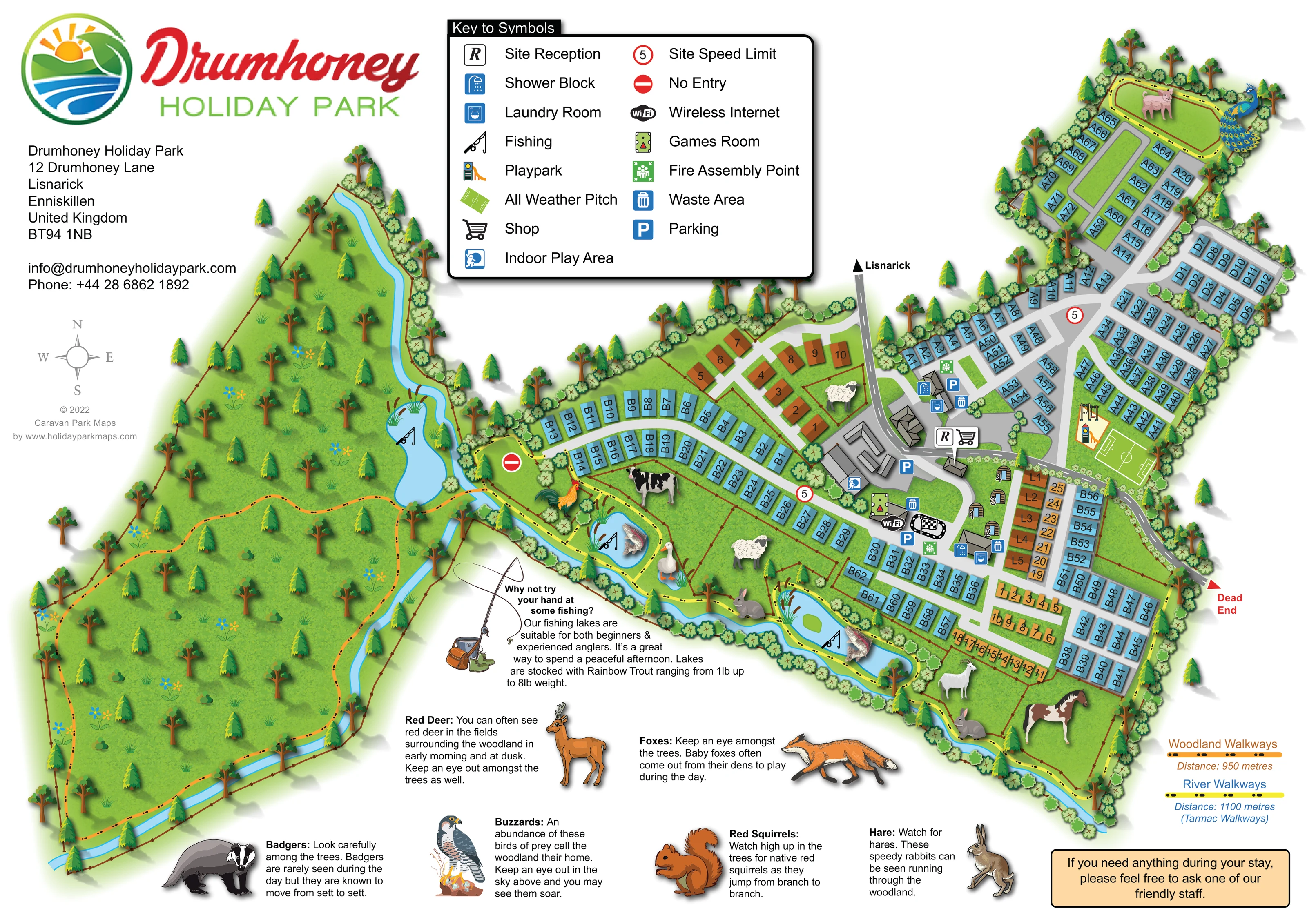
An extensive wooded area occupies the left side of the plan, with mixed tree illustrations, flowers, grass textures and a looping walk.
ILLUSTRATED PARK MAP · P451
Drumhoney Holiday Park, 12 Drumhoney Lane, Lisnarick, Enniskillen, United Kingdom · United Kingdom
 Enlarge the map ↗
A SENSE OF THE PLACE
Drumhoney Holiday Park is set in private parkland near Lisnarick in County Fermanagh. Caravan accommodation, camping pods and touring pitches offer different ways to stay in the Fermanagh Lakelands.
Countryside views and fishing are part of the park's character, with trout lakes reserved for its residents. Castle Archdale and the shores of Lower Lough Erne provide nearby opportunities to explore woodland and waterside landscapes.
LOOK CLOSER
An extensive wooded area occupies the left side of the plan, with mixed tree illustrations, flowers, grass textures and a looping walk.
A winding blue watercourse links the western woodland and the southern edge of the accommodation, widening into fishing pools.
Fenced grassy spaces contain illustrations of cattle, sheep, a horse, rabbits, poultry and pigs. These are prominent landscape landmarks, but no named animal attraction or visitor interaction is specified.
Illustrated notes introduce red deer, badgers, foxes, red squirrels, buzzards and hares as wildlife associated with the woodland and surrounding fields.
An R symbol marks reception beside the central arrival road and building cluster.
A shopping trolley symbol appears beside reception.
Blue shower symbols identify facilities in the central hub and near the pod and L-labelled area.
Laundry symbols are grouped with the shower facilities.
An R symbol marks reception beside the central arrival road and building cluster.
A shopping trolley symbol appears beside reception.
Blue shower symbols identify facilities in the central hub and near the pod and L-labelled area.
Laundry symbols are grouped with the shower facilities.
Repeated blue bin symbols mark waste areas around the principal facilities.
Blue P markers identify parking around reception and other central buildings.
The indoor play symbol is attached to the larger building on the western side of the central facilities.
A pool-table symbol marks the games room near the central recreation cluster.
A Wi-Fi symbol is shown beside the games room; it does not define a coverage area.
Illustrated play equipment stands beside the sports pitch in the eastern accommodation area.
A bright green rectangular pitch with white playing lines lies alongside the playpark.
An oval black track with a chequered flag is drawn beside the games room. Its specific activity is not named in the key.
Several blue pools along the watercourse carry fishing-rod symbols, with fish illustrations on two of them.
A fishing callout describes rainbow trout fishing for beginners and experienced anglers.
An extensive wooded area occupies the left side of the plan, with mixed tree illustrations, flowers, grass textures and a looping walk.
A winding blue watercourse links the western woodland and the southern edge of the accommodation, widening into fishing pools.
The orange route is labelled Woodland Walkways, with a mapped distance of 950 metres.
The yellow route follows the water and animal-enclosure edge. Its key gives 1,100 metres and describes it as tarmac walkways.
Fenced grassy spaces contain illustrations of cattle, sheep, a horse, rabbits, poultry and pigs. These are prominent landscape landmarks, but no named animal attraction or visitor interaction is specified.
Illustrated notes introduce red deer, badgers, foxes, red squirrels, buzzards and hares as wildlife associated with the woodland and surrounding fields.
The principal road enters the central facilities from the top of the plan, with a directional arrow towards Lisnarick.
The artwork includes circular 5 speed signs, a no-entry symbol at the western road end and a red Dead End arrow on the eastern edge.
Green assembly symbols are positioned near the central facilities.
READING THE MAP
This illustrated map of Drumhoney Holiday Park brings together accommodation, family facilities and countryside walks on a single landscape-format page. Set near Lisnarick in County Fermanagh, the park is presented as more than a collection of caravan rows: woodland, fishing pools and a winding watercourse give the artwork its distinctive shape.
The accommodation occupies the centre and right of the plan, with blue caravan-style units arranged along curved roads and branching lanes. Smaller brown-coloured groups and a cluster of camping pods add variety. Reception, the shop and shared facilities sit around the main arrival junction, while the outdoor playpark and all-weather pitch are easy to pick out further east.
On the left, an extensive illustrated woodland is crossed by an orange walking route. A separate yellow route follows the water and the edge of fenced animal spaces. Wildlife drawings and short explanatory notes extend the map into a visitor guide, encouraging interest in the surrounding landscape. A prominent symbol key, numbered accommodation and clear route colours keep this richly illustrated page useful for everyday orientation.
The plan is organised around a central arrival road, marked with an arrow towards Lisnarick. This leads into a cluster of buildings and parking areas where reception and the shop are identified by large symbols. Nearby icons locate showers, laundry facilities, waste areas, indoor play, a games room and wireless internet. A small oval track with a chequered flag is also illustrated, although its activity is not named.
Accommodation roads branch out from this hub. The northern A area uses a series of short lanes and elongated green spaces, while the B area curves westwards before continuing into denser rows in the south-east. Blue rectangular units carry letter-number labels. Brown accommodation symbols form several contrasting groups, including an L-labelled row, and a handful of curved-roof pods sit beside the central facilities. The artwork does not include a key defining every accommodation category.
A playpark and marked all-weather sports pitch sit together on the eastern side. Fenced grassy enclosures containing large animal illustrations run between some of the accommodation and the water. Several fishing pools are identified with rod symbols, supported by a separate trout-fishing information panel.
The western woodland is treated as a substantial destination in its own right. Mixed trees, flowers and grass textures surround an orange walking loop, labelled as 950 metres. The yellow river route follows the blue watercourse and is described in the route key as a 1,100-metre tarmac walk. Wildlife notes along the lower margin feature deer, badgers, foxes, squirrels, buzzards and hares.
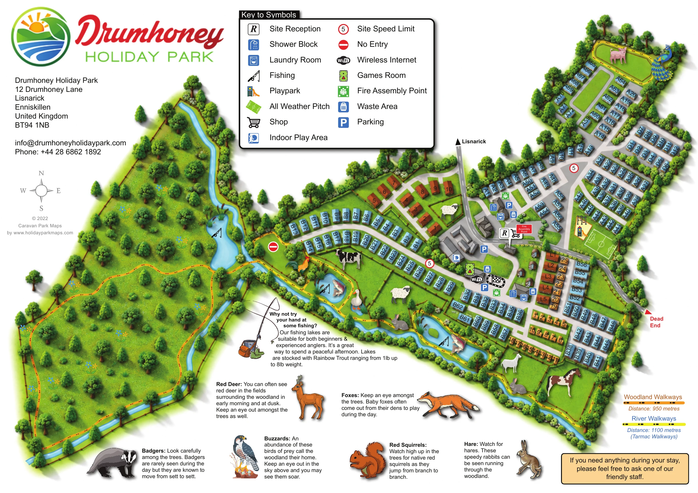
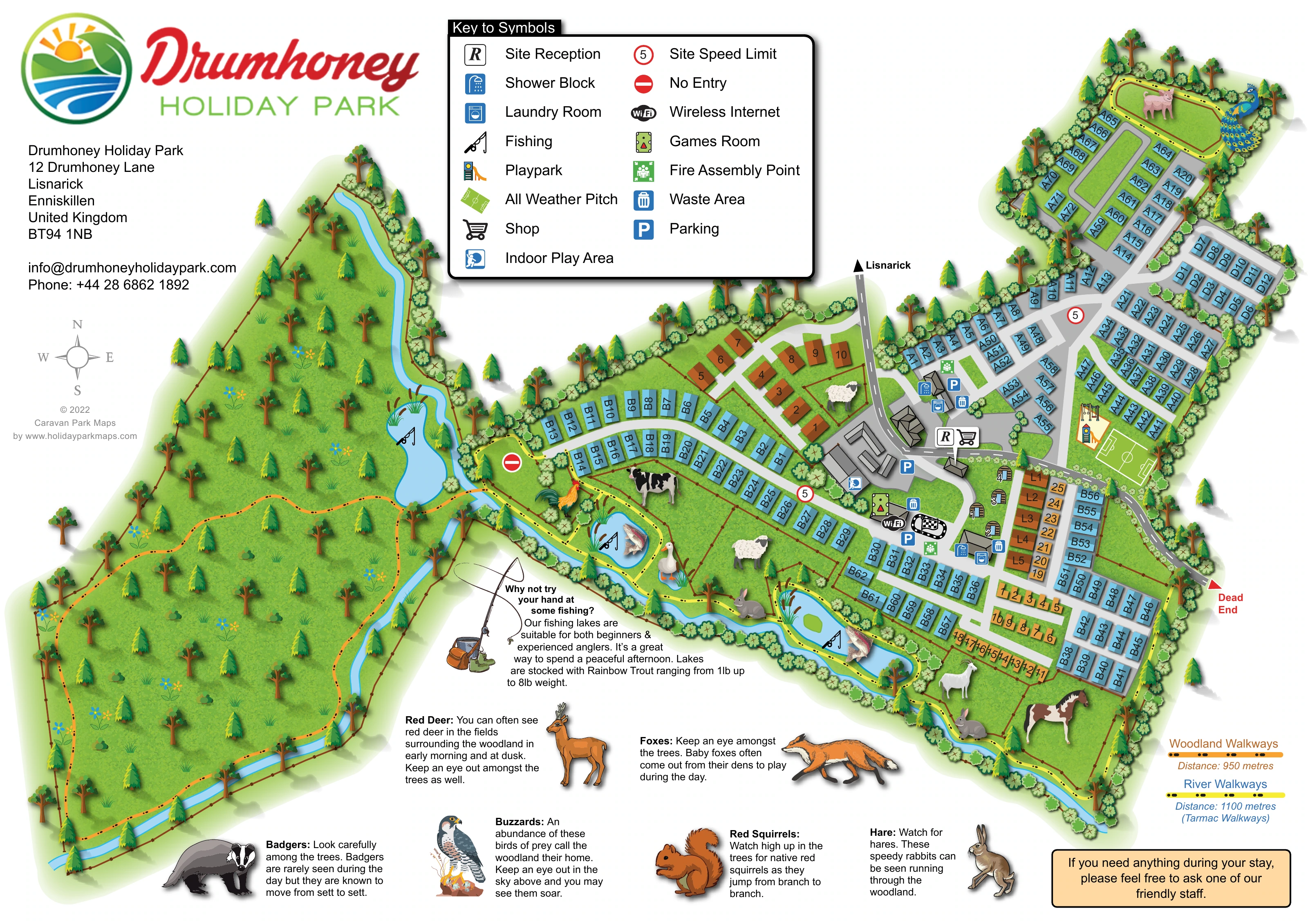
The single-page composition includes the park logo, contact details, compass, facility key and walking-route key. The enlarged legend view shows part of this same artwork rather than a separate map or additional accommodation area.
 Enlarge this map ↗
KEEP EXPLORING
Chosen for shared landscapes, accommodation or facilities.
 Explore the map ↗
United Kingdom
Woodland park map with mixed pitches, bell tents, lodges and a fishing lake.
 Explore the map ↗
United Kingdom
Woodland holiday homes, named camping fields and farm buildings on a colour-coded Nether Wasdale park map.
 Explore the map ↗
United Kingdom
A woodland estate park map combining caravan loops, touring pitches, riverside paths and Bruce’s Cave landmarks.
Features may come from the sample artwork, its key or published park information. Approximate numbers describe the drawing and may cover only part of a park. They are intended to help you compare map examples. Current facilities and booking information should be checked with the park.
TAKE A CLOSER LOOK
View the illustrated map in detail or choose a file to download. These are sample maps; contact the park for current visitor information.



LET’S MAP YOUR PARK
For a map quotation, find your park and draw a rough boundary around it. The area you select helps us work out the design time and price.
Draw your park for a quote ↗Or talk to our map designers
01751 473136
 drumhoney_large.png