
Macalister River
A broad, labelled blue river follows the southern and eastern edges of the depiction, with pale current textures and scattered stones.
ILLUSTRATED PARK MAP · P188
14 Jamieson-Licola Road, Licola, Victoria · Australia
 Enlarge the map ↗
A SENSE OF THE PLACE
Licola Village Store and Holiday Park provides accommodation for visitors to Victoria's High Country. Camping and caravan spaces sit alongside cabins and bunkhouse accommodation.
The range of options suits travellers bringing their own equipment as well as those seeking a self-contained stay. The map provides an overview of the holiday park and its place within the small community of Licola.
LOOK CLOSER
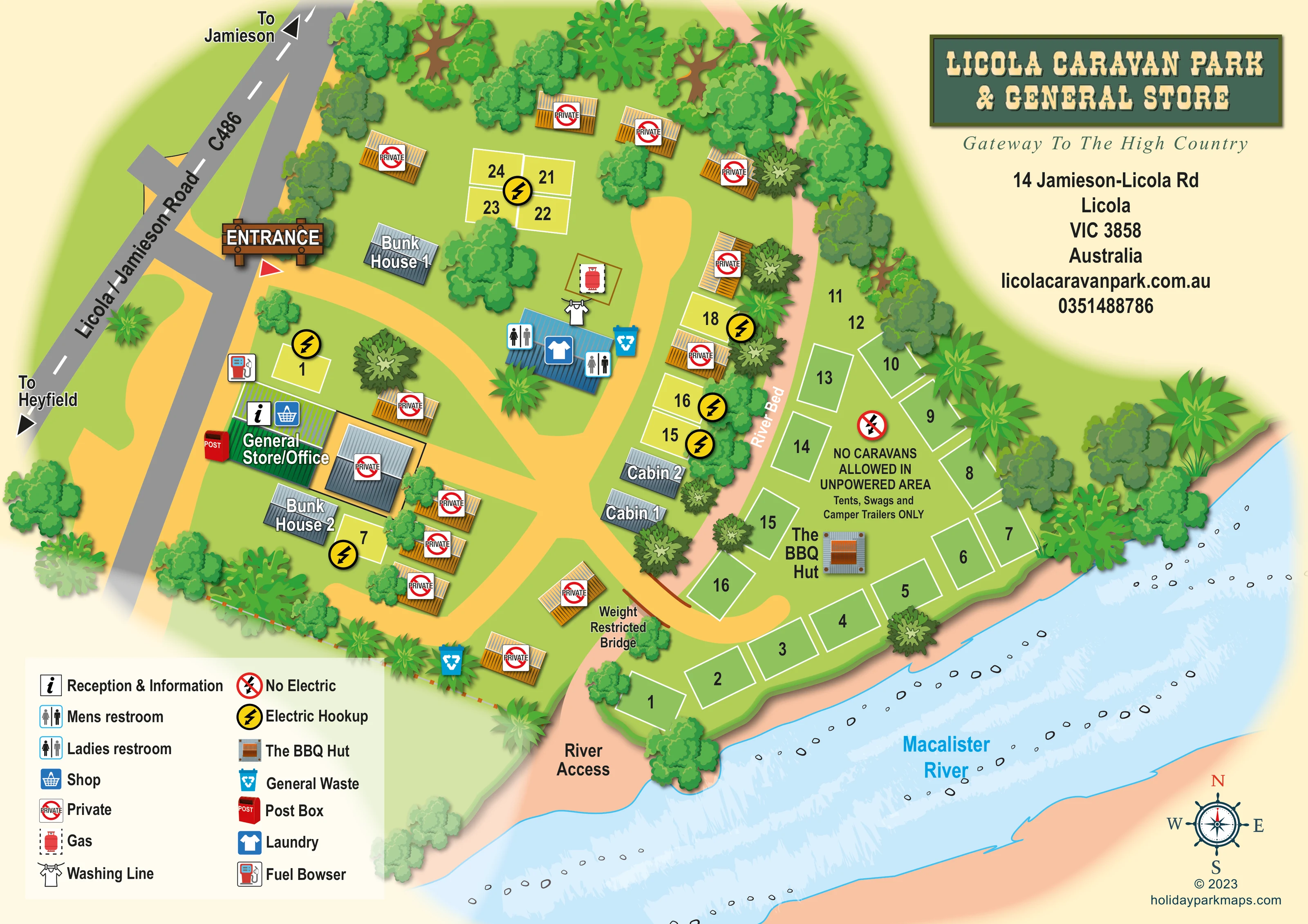
A broad, labelled blue river follows the southern and eastern edges of the depiction, with pale current textures and scattered stones.
A peach-coloured strip labelled River Bed separates the main accommodation and amenities area from the riverside camping section.
Dense illustrated trees line the road, riverbank and outer boundaries, with smaller clusters between buildings and pitches.
A green-roofed building close to the entrance carries the General Store/Office label, information symbol and shop symbol.
A fuel-pump symbol is positioned beside the store on the roadside edge of the park.
A red illustrated post box stands beside the General Store/Office.
Separate men's and ladies' symbols identify the central blue-roofed amenities building.
A blue shirt symbol marks the laundry within the central amenities building.
A green-roofed building close to the entrance carries the General Store/Office label, information symbol and shop symbol.
A fuel-pump symbol is positioned beside the store on the roadside edge of the park.
A red illustrated post box stands beside the General Store/Office.
Separate men's and ladies' symbols identify the central blue-roofed amenities building.
A blue shirt symbol marks the laundry within the central amenities building.
A clothes-line symbol is placed immediately above the amenities building.
A red gas-cylinder symbol marks a small outlined area near the amenities building.
Blue bin symbols appear beside the amenities building and near the southern boundary; the legend identifies them as general waste.
Large yellow lightning symbols identify powered pitches scattered through the main park.
A small illustrated barbecue hut is labelled within the unpowered riverside camping area.
Several orange-roofed structures and a grey-roofed building beside the store carry prominent red private symbols. Their specific uses are not stated.
A broad, labelled blue river follows the southern and eastern edges of the depiction, with pale current textures and scattered stones.
A peach-coloured strip labelled River Bed separates the main accommodation and amenities area from the riverside camping section.
Dense illustrated trees line the road, riverbank and outer boundaries, with smaller clusters between buildings and pitches.
A timber-style entrance sign marks the access from Licola/Jamieson Road on the western side.
The grey approach road is labelled C486, with directional arrows towards Jamieson and Heyfield.
Broad golden-yellow tracks branch from the entrance around the store, amenities, accommodation and bridge approach.
A labelled bridge crosses the river-bed corridor to the riverside camping area. No numerical weight limit is shown.
A broad peach-coloured opening towards the river is explicitly labelled River Access near the lower end of the river-bed corridor.
The artwork places a no-electric symbol and a prominent tents, swags and camper-trailers-only notice within the riverside area, distinguishing it from the powered pitches.
READING THE MAP
This illustrated map of Licola Caravan Park & General Store places a small holiday park within its distinctive Macalister River setting in Victoria's High Country. The river sweeps across the lower edge of the page, while the Licola/Jamieson Road forms the approach on the left. Between them, tree-lined grounds contain powered pitches, two cabins, two bunkhouses and a separate unpowered camping area.
The map makes the park's unusual arrangement easy to understand. A peach-coloured river-bed corridor divides the main facilities from the riverside pitches, with a labelled bridge connecting the two areas. The General Store/Office is prominent near the entrance, alongside fuel and post-box symbols, while a central blue-roofed building brings together the toilets and laundry.
Golden tracks, large pitch numbers and contrasting service icons give the illustration a practical wayfinding structure. Layered trees, textured roofs and flowing river detail retain the character of the setting. A rustic green title panel, a generous symbol key and a compass rose complete a single-sheet design that introduces both the accommodation layout and the park's relationship with the river.
The single landscape-format plan is organised around three strong features: the diagonal C486 approach road, the branching yellow internal tracks and the Macalister River along the lower and right-hand edges. Direction arrows point towards Jamieson and Heyfield, and a timber-style entrance sign identifies the turn into the park. Just inside, the green-roofed General Store/Office carries reception and shop symbols, with a red post box and a fuel bowser nearby.
Accommodation is distributed in small groups rather than long uniform rows. Powered pitches are marked with conspicuous yellow lightning discs, including a compact group towards the top of the plan. Two labelled bunkhouses sit on the entrance and store side; two grey-roofed cabins stand beside the narrow river-bed corridor. Orange-roofed buildings bearing private symbols are interspersed through the grounds, keeping them visually distinct from the labelled visitor accommodation.
The central blue-roofed amenities building is marked for men's and ladies' toilets and laundry. A washing-line symbol and gas point sit nearby, and general-waste bins are shown at two locations. Across the river bed, white-outlined unpowered pitches follow the riverbank and surround the BBQ hut. The artwork's prominent area notice specifies tents, swags and camper trailers, while the connecting bridge is labelled weight restricted. A separate River Access label identifies an opening towards the water.
The river is illustrated with pale current textures, stones and peach-coloured banks. Dense, varied tree canopies frame the pitches and buildings. A two-column legend sits at lower left, the title and contact panel at upper right, and a compass rose at lower right. The enlarged quadrant views show details of this same sheet rather than separate map variants.
KEEP EXPLORING
Chosen for shared landscapes, accommodation or facilities.
 Explore the map ↗
Australia
Numbered cabin rows, central amenities and wooded Ovens River frontage at Bundalong Riverside Resort.
 Explore the map ↗
United Kingdom
Woodland camping, lodges, lakes and colour-coded bike trails at Avon Tyrrell Outdoor Centre.
 Explore the map ↗
United Kingdom
Woodland park map with mixed pitches, bell tents, lodges and a fishing lake.
Features may come from the sample artwork, its key or published park information. Approximate numbers describe the drawing and may cover only part of a park. They are intended to help you compare map examples. Current facilities and booking information should be checked with the park.
LET’S MAP YOUR PARK
For a map quotation, find your park and draw a rough boundary around it. The area you select helps us work out the design time and price.
Draw your park for a quote ↗Or talk to our map designers
01751 473136