
Recreational space / camping
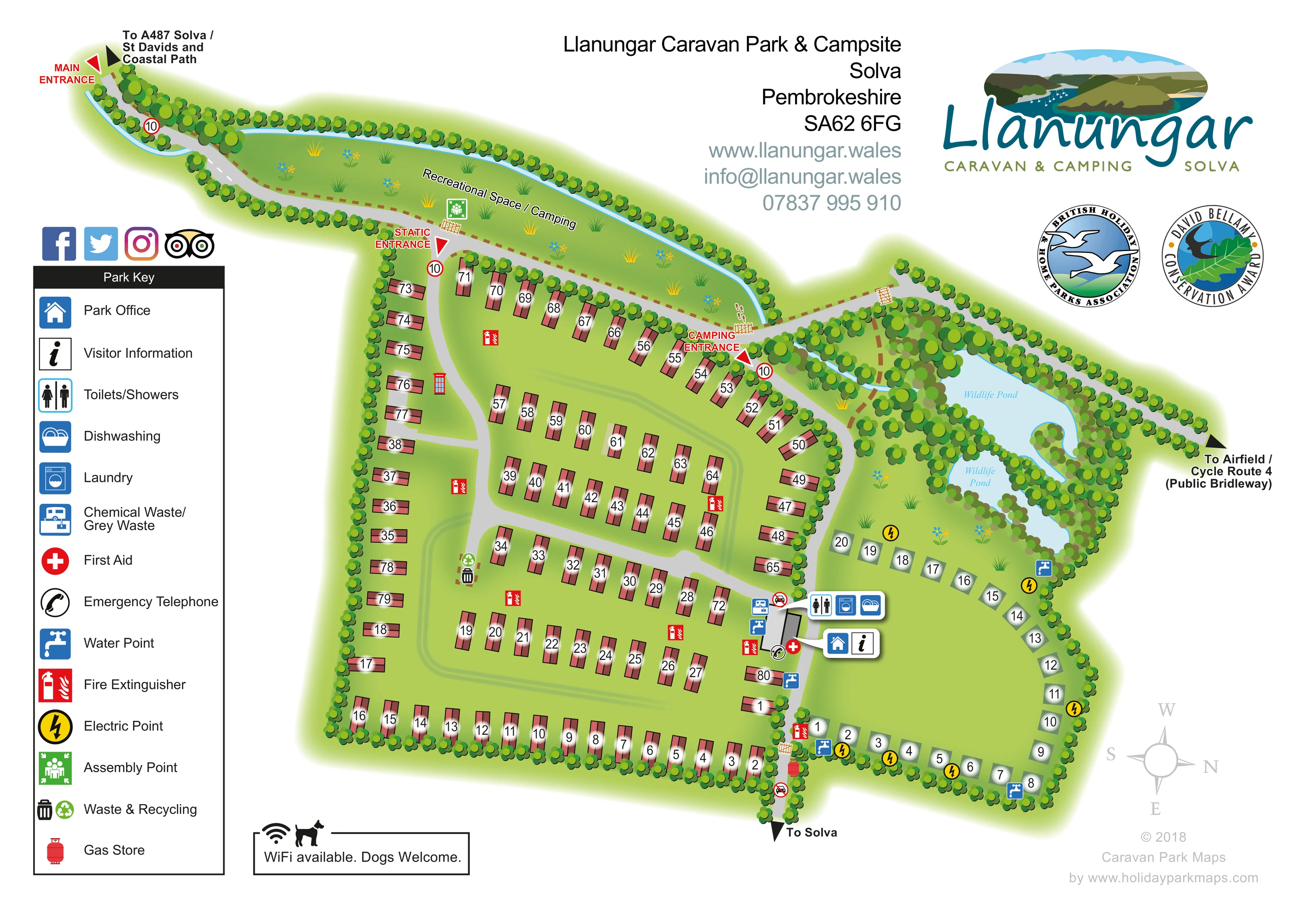
A long, tree-bordered grass strip follows the northern approach road and is explicitly labelled for recreation and camping.
ILLUSTRATED PARK MAP · P525
Llanungar Caravan Park & Campsite, Solva, Pembrokeshire · United Kingdom
 Enlarge the map ↗
A SENSE OF THE PLACE
Llanungar Caravan Park and Campsite lies near Solva in Pembrokeshire, surrounded by farmland, lanes and walking routes. Sea views extend across St Brides Bay, with a pond, stream and managed wildlife habitats within the grounds.
Camping pitches and holiday caravans provide different ways to stay or return as an owner. Laundry and washing facilities support visits, while the coast path and St Davids peninsula offer opportunities to explore beyond the park.
LOOK CLOSER
A long, tree-bordered grass strip follows the northern approach road and is explicitly labelled for recreation and camping.
Two labelled pale-blue pond areas form an irregular, wooded wetland feature at the north-eastern edge of the camping field.
A narrow blue watercourse follows the northern boundary and continues into the pond landscape.
Dense illustrated tree belts define the park edges, separate the accommodation areas and surround the wildlife ponds.
Paired office and information symbols identify the central service area beside the boundary between the static and camping sections.
A grouped blue-and-white symbol panel locates these facilities at the central service building, convenient to the eastern camping field.
The disposal symbol is placed immediately beside the service building on the static-caravan side.
Repeated blue tap symbols appear around the camping perimeter and near the central facilities.
Paired office and information symbols identify the central service area beside the boundary between the static and camping sections.
A grouped blue-and-white symbol panel locates these facilities at the central service building, convenient to the eastern camping field.
The disposal symbol is placed immediately beside the service building on the static-caravan side.
Repeated blue tap symbols appear around the camping perimeter and near the central facilities.
Yellow circular lightning symbols mark several positions around the camping field; they do not establish that every pitch has an individual connection.
A paired bin and recycling marker sits beside an internal road in the static-caravan section.
First-aid and telephone symbols sit near the service hub. Red fire-extinguisher symbols are distributed through the accommodation areas, and a red telephone-box illustration appears beside the western internal road.
A green assembly-point marker is shown in the northern recreational space/camping strip.
A red gas-cylinder symbol is positioned near the southern route towards Solva.
A long, tree-bordered grass strip follows the northern approach road and is explicitly labelled for recreation and camping.
Two labelled pale-blue pond areas form an irregular, wooded wetland feature at the north-eastern edge of the camping field.
A narrow blue watercourse follows the northern boundary and continues into the pond landscape.
Dense illustrated tree belts define the park edges, separate the accommodation areas and surround the wildlife ponds.
Red arrowheads distinguish the main entrance at the north-western tip, the turn into the static section and the camping entrance farther east.
Broad grey roads connect the approach, caravan rows, camping section and southern exit route. Brown dashed lines show secondary routes through the northern grass and pond-side area, with small crossing symbols.
Directional labels point towards the A487, Solva, St Davids and the coastal path at the main entrance, with another arrow towards Solva at the southern edge.
An eastward arrow identifies the connection to the airfield and Cycle Route 4, explicitly labelled Public Bridleway.
A boxed footer statement reads WiFi available. Dogs Welcome. This records the wording on the artwork rather than establishing a current service or pet policy.
READING THE MAP
This illustrated map of Llanungar Caravan Park & Campsite brings together a static-caravan area, a separate camping field and a distinctive wildlife landscape near Solva in Pembrokeshire. Its long, tree-lined approach gives the plan an unusual shape, with the main entrance at the north-western tip and clearly marked turns into the static and camping sections.
The artwork uses red caravan roofs, pale camping markers and large pitch numbers to make the accommodation areas easy to distinguish. A central service hub is identified with grouped symbols for the park office, visitor information, toilets and showers, laundry and dishwashing. Water points, electric points and other practical facilities are shown around the grounds.
The setting is an important part of the composition. Two labelled wildlife ponds sit among dense trees beside the camping field, while a narrow watercourse follows the northern boundary. An elongated recreational space also carries a camping label. Directional arrows connect the internal plan with Solva, St Davids, the coastal path and a public bridleway towards Cycle Route 4, giving visitors a useful picture of both the site and its surroundings.
The single-page plan is organised around a curving arrival road that enters from the upper left and follows the northern edge of the park. Red entrance labels mark the main arrival point, the turn into the static-caravan enclosure and the camping entrance farther east. A long green strip between the road and the boundary watercourse is labelled Recreational Space / Camping, with an assembly-point symbol and small illustrated plants.
Most of the accommodation occupies the western and central enclosure. Terracotta caravan symbols form rows around its outer edges and several internal groups, separated by broad grey roads and grass margins. Large black numbers over white highlights remain prominent against the coloured roofs. The eastern camping field uses pale numbered pitch markers around an open lawn, with yellow electric-point symbols and blue water taps placed at intervals.
At the meeting point of the two accommodation areas, a small service building is accompanied by rounded white panels for toilets and showers, laundry, dishwashing, the park office and visitor information. Nearby symbols identify waste disposal, first aid and an emergency telephone. Fire extinguishers are marked across the grounds, while waste and recycling appear beside an internal road and a gas store is shown near the southern route.
The wooded north-eastern corner contains two labelled wildlife ponds, linked visually with the narrow blue watercourse. Brown dashed routes and small crossing symbols add detail around the northern grass and pond landscape. Outward arrows identify routes towards Solva, the A487, St Davids, the coastal path and the airfield/Cycle Route 4 public bridleway. A tall left-hand key, upper-right branding and lower-right compass complete the composition. The accompanying enlargement reveals the same legend and caravan area in greater detail, rather than a separate map variant.
KEEP EXPLORING
Chosen for shared landscapes, accommodation or facilities.
 Explore the map ↗
United Kingdom
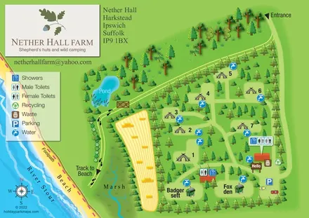
Tree-sheltered camping and named shepherd’s huts beside the River Stour at Nether Hall Farm.
 Explore the map ↗
United Kingdom
A colour-zoned coastal park map with touring areas, woodland trails, ponds and a leisure club.
 Explore the map ↗
United Kingdom
A woodland estate park map combining caravan loops, touring pitches, riverside paths and Bruce’s Cave landmarks.
Features may come from the sample artwork, its key or published park information. Approximate numbers describe the drawing and may cover only part of a park. They are intended to help you compare map examples. Current facilities and booking information should be checked with the park.
TAKE A CLOSER LOOK
View the illustrated map in detail or choose a file to download. These are sample maps; contact the park for current visitor information.


LET’S MAP YOUR PARK
For a map quotation, find your park and draw a rough boundary around it. The area you select helps us work out the design time and price.
Draw your park for a quote ↗Or talk to our map designers
01751 473136