
Tree-lined boundaries and planted spaces
Stylised trees and shrubs form dense perimeter belts, line the dog field and recreation enclosures, and punctuate the grassy islands within accommodation loops.
ILLUSTRATED PARK MAP · P524
Out Gang Lane, Skipton, Yorkshire Dales · United Kingdom
 Enlarge the map ↗
A SENSE OF THE PLACE
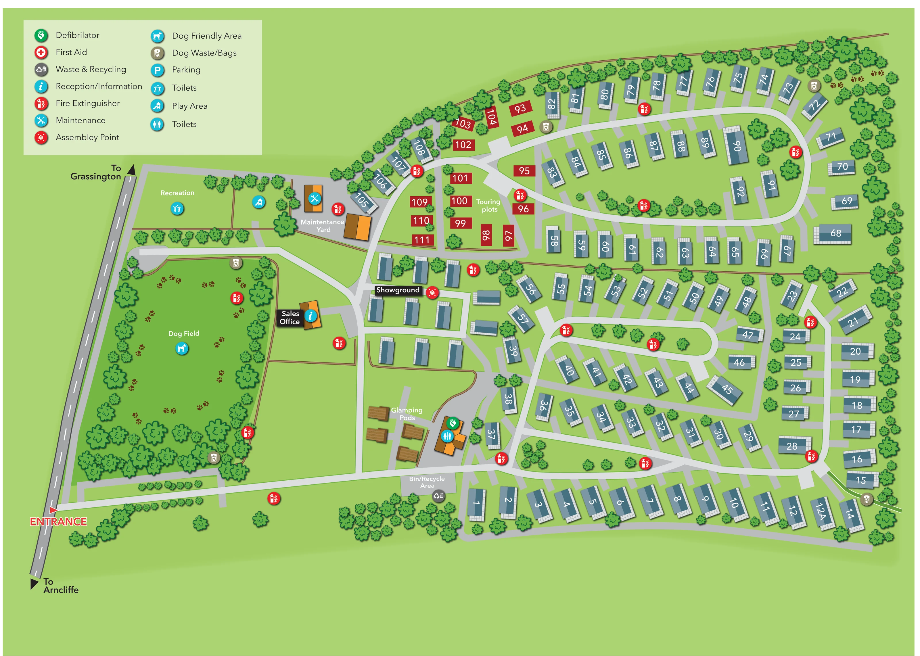
Littondale Country & Leisure Park is based at Out Gang Lane, Skipton, Yorkshire Dales. The glamping pods face Arncliffe, Hawkswick Cotes and the surrounding Yorkshire dale. The park provides six glamping pods and a small touring area.
Pods have kitchenettes and private shower rooms; tourers have shared shower and toilet facilities.
LOOK CLOSER
Stylised trees and shrubs form dense perimeter belts, line the dog field and recreation enclosures, and punctuate the grassy islands within accommodation loops.
Thin brown boundary lines define the dog field, recreation spaces, service yard and portions of the accommodation layout.
A red arrow and prominent outlined ENTRANCE label mark access from the road along the left edge.
Black directional arrows label Grassington towards the top of the roadside strip and Arncliffe towards the bottom.
A long entrance approach connects to branching pale-grey roads, rounded accommodation loops and short individual plot accesses.
An orange-roofed building beside the dog field is labelled Sales Office and carries the reception/information symbol.
A labelled central-western display area contains unnumbered caravan-style units arranged in short rows.
A grey-surfaced yard with two orange-roofed buildings and a maintenance symbol sits beside the recreation space and touring area.
A red arrow and prominent outlined ENTRANCE label mark access from the road along the left edge.
Black directional arrows label Grassington towards the top of the roadside strip and Arncliffe towards the bottom.
A long entrance approach connects to branching pale-grey roads, rounded accommodation loops and short individual plot accesses.
An orange-roofed building beside the dog field is labelled Sales Office and carries the reception/information symbol.
A labelled central-western display area contains unnumbered caravan-style units arranged in short rows.
A grey-surfaced yard with two orange-roofed buildings and a maintenance symbol sits beside the recreation space and touring area.
A large separate green enclosure on the western side is labelled Dog Field, with a dog-friendly symbol and decorative paw prints.
Olive-coloured dog-waste/bag symbols appear around the dog field and at several accommodation-edge locations.
A labelled open recreation space lies near the roadside in the upper-left portion of the park.
A turquoise play-area symbol marks the smaller enclosure between the recreation space and maintenance yard.
The orange-roofed facilities building next to the glamping pods carries the male/female toilet symbol.
A green AED symbol marks the facilities building beside the pods.
Repeated red extinguisher symbols are distributed along accommodation roads and around the entrance-side activity and service areas.
A red assembly-point symbol appears beside the showground label.
A labelled grey Bin/Recycle Area with a waste-and-recycling symbol sits beside the entrance approach, below the pod facilities.
First aid is included in the key, but no separate first-aid location is clearly marked on the plan.
Parking appears in the legend; no distinct P marker is clearly visible on the main plan.
Stylised trees and shrubs form dense perimeter belts, line the dog field and recreation enclosures, and punctuate the grassy islands within accommodation loops.
Thin brown boundary lines define the dog field, recreation spaces, service yard and portions of the accommodation layout.
READING THE MAP
This illustrated map of Littondale Country & Leisure Park brings together a substantial caravan layout, a smaller touring area and a separate glamping-pod group in the Yorkshire Dales. The plan gives visitors a clear starting point at the roadside entrance, with directions towards Grassington and Arncliffe helping to place the arrival route in its local setting.
Most of the accommodation lies along curved roads across the centre and right of the page. Blue-grey caravan roofs and white plot numbers establish a consistent visual rhythm, while red touring plots and timber-coloured pods make the smaller accommodation groups easy to distinguish. Along the western side, the map gives generous space to the dog field, recreation area, play area and maintenance yard.
The sales office and showground add a distinctive commercial element to the layout. A large pictogram key explains the facility and safety markers, including toilets, recycling, dog-waste points and the defibrillator beside the pod facilities. The result is a practical example of combining numbered accommodation, visitor amenities and operational spaces within one illustrated park plan.
The plan is organised around a left-edge approach road, with the entrance marked near the lower-left corner. A pale-grey access route extends across the lower portion of the park, passing the large dog field before reaching the glamping pods, facilities building and labelled bin and recycling area. Branching routes then connect to the main accommodation layout and the western sales and service spaces.
Fixed caravan-style units occupy much of the centre and right. They are drawn with two-tone blue-grey roofs, pale gridded surrounds and prominent white plot numbers. Curved roads create several elongated loops, with trees and grass inside them, while further units follow the southern and eastern boundaries. The touring area sits towards the upper centre, where red numbered rectangles distinguish pitches from the illustrated fixed units. The pods form a compact timber-coloured group beside the toilet building, which also carries a green defibrillator marker.
On the western side, the dog field is a particularly strong landmark: a darker green enclosure framed by trees and brown boundary lines, with scattered paw-print motifs. Above it are the recreation space, a marked play area and the maintenance yard. The sales office carries an information symbol, and the adjoining showground contains short rows of unnumbered display units with an assembly-point marker nearby.
Repeated extinguisher and dog-waste symbols provide distributed reference points. A large two-column legend sits in the upper-left corner, while roadside arrows identify directions to Grassington and Arncliffe. This is a single complete map composition, without a separate inset or reverse-side variant.
KEEP EXPLORING
Chosen for shared landscapes, accommodation or facilities.
 Explore the map ↗
United Kingdom
Woodland-framed Barnsoul map with mixed accommodation, shared facilities and paw-marked walking routes.
 Explore the map ↗
United Kingdom
Riverside park map with named pitch fields, illustrated huts and a paw-print dog walk.
 Explore the map ↗
United Kingdom
A woodland estate park map combining caravan loops, touring pitches, riverside paths and Bruce’s Cave landmarks.
Features may come from the sample artwork, its key or published park information. Approximate numbers describe the drawing and may cover only part of a park. They are intended to help you compare map examples. Current facilities and booking information should be checked with the park.
LET’S MAP YOUR PARK
For a map quotation, find your park and draw a rough boundary around it. The area you select helps us work out the design time and price.
Draw your park for a quote ↗Or talk to our map designers
01751 473136