
Llyn Gwynant Lake
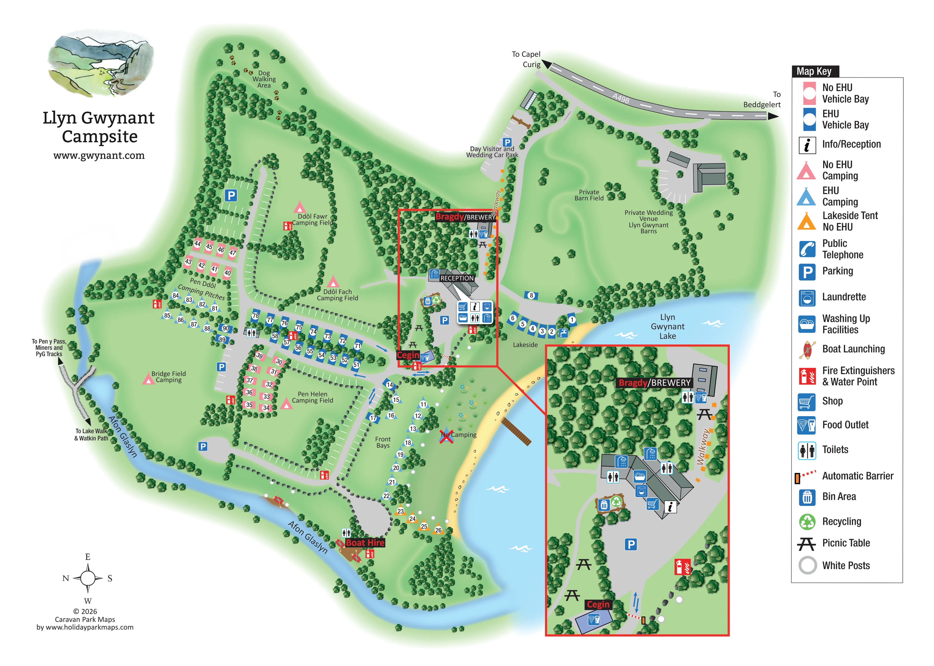
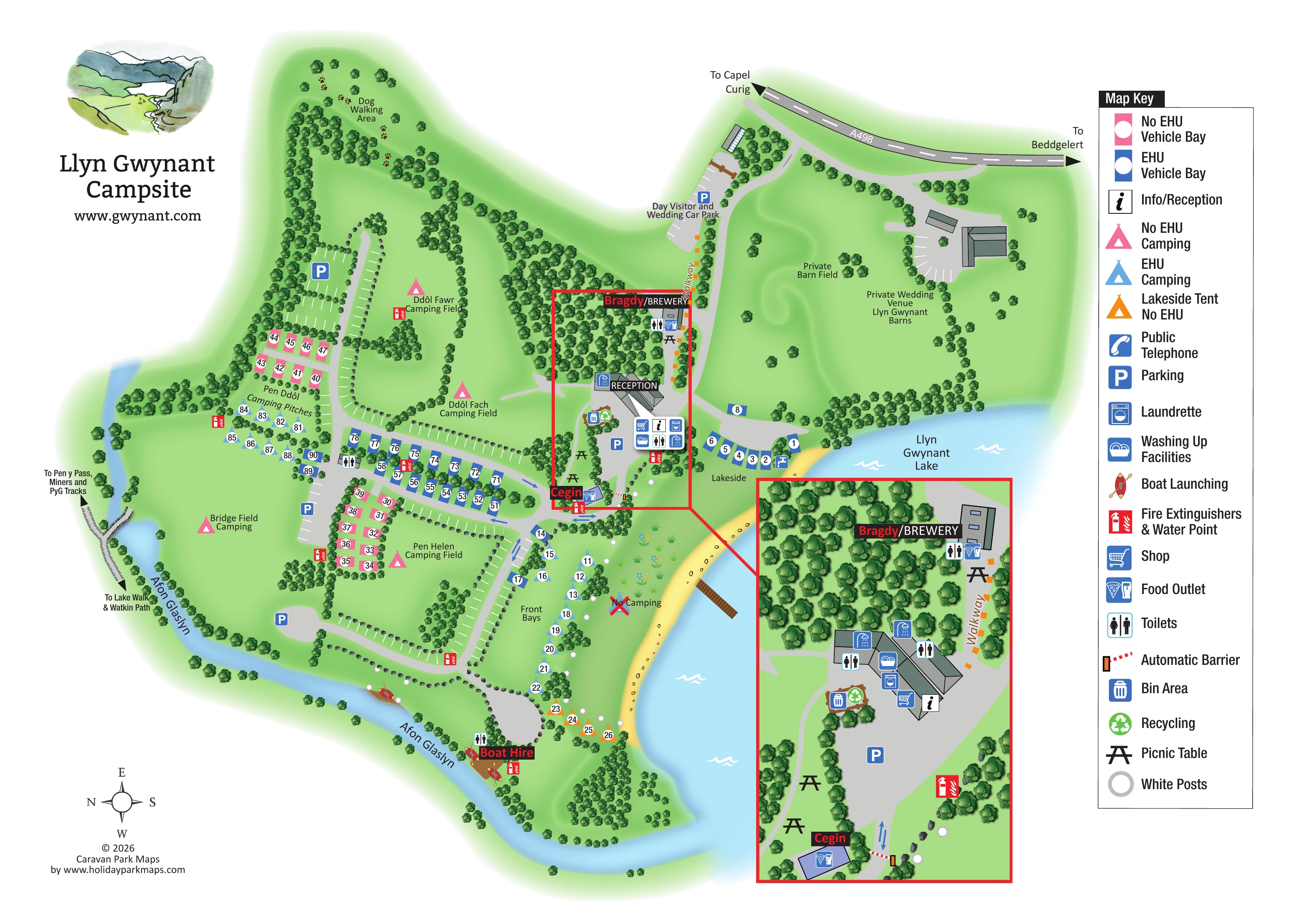
The blue lake occupies the right side of the campsite, with a yellow shoreline, lakeside accommodation groups and a short projecting timber-coloured landing structure.
ILLUSTRATED PARK MAP · P193
Nant Gwynant, Caernarfon · United Kingdom
 Enlarge the map ↗
A SENSE OF THE PLACE
Llyn Gwynant Campsite lies beside the lake in the Nant Gwynant valley within Eryri. It is primarily a tent-camping site on natural ground, with limited spaces for smaller vans.
Woodland, river and mountain scenery are central to the experience, with walking access towards Yr Wyddfa. Shared facilities include toilets and washing-up areas, while food and drink are offered at the Cegin and the on-site brewery.
LOOK CLOSER
The blue lake occupies the right side of the campsite, with a yellow shoreline, lakeside accommodation groups and a short projecting timber-coloured landing structure.
The river curves along the western and southern edges of the camping ground before meeting the lake, giving the site a strongly water-defined outline.
Dense illustrated tree belts divide the camping fields, frame the river and shoreline, and surround the central service buildings.
A named dog walking area occupies the wooded upper-left end of the site, with paw-print motifs marking its character.
A crossed-out tent symbol and 'No Camping' label distinguish an area between Front Bays and the shoreline.
Reception is labelled in the central service area beside the principal arrival route, with an information symbol repeated in the enlarged inset.
A shopping-trolley symbol identifies the shop at the main reception and facilities building.
Toilet symbols appear at the central facilities, brewery, near the camping rows and beside the boat-hire area.
Reception is labelled in the central service area beside the principal arrival route, with an information symbol repeated in the enlarged inset.
A shopping-trolley symbol identifies the shop at the main reception and facilities building.
Toilet symbols appear at the central facilities, brewery, near the camping rows and beside the boat-hire area.
Blue washing-up symbols are positioned at the main service building and are made clearer by the enlarged inset.
A washing-machine symbol marks laundry facilities in the reception building cluster.
Shower pictograms are placed on the main facilities building in the inset, although they are not separately named in the displayed key.
Cegin is labelled beside a small building near the barrier at the southern end of the central service area, with a food-outlet symbol.
The brewery is prominently labelled beside the woodland walkway, with adjacent food, toilet and picnic-table symbols.
Black table pictograms mark seating around the brewery, reception approach and Cegin.
Boat Hire is labelled at the southern riverside access area, near toilets and a fire-extinguisher and water-point symbol.
Canoe-and-paddle symbols identify launching locations along the Afon Glaslyn near the boat-hire area.
Repeated red combined symbols mark fire-extinguisher and water-point locations across the camping areas and service hub. A separate blue tap symbol is shown beside the lakeside vehicle bays.
Bin and green recycling symbols are grouped beside the main reception and facilities area.
Several blue parking symbols identify parking around the camping fields and service hub. A separate car park near the A498 is labelled for day visitors and weddings.
A public-telephone symbol is included in the key; its location is not clearly identifiable in the artwork.
A separate group of grey-roofed buildings and parking is labelled as the private wedding venue, beside the Private Barn Field.
The blue lake occupies the right side of the campsite, with a yellow shoreline, lakeside accommodation groups and a short projecting timber-coloured landing structure.
The river curves along the western and southern edges of the camping ground before meeting the lake, giving the site a strongly water-defined outline.
Dense illustrated tree belts divide the camping fields, frame the river and shoreline, and surround the central service buildings.
A named dog walking area occupies the wooded upper-left end of the site, with paw-print motifs marking its character.
A crossed-out tent symbol and 'No Camping' label distinguish an area between Front Bays and the shoreline.
The A498 runs across the top of the plan, with arrows towards Capel Curig and Beddgelert. An access road leads down to reception and the camping routes.
Grey drives loop around the camping fields and branch towards the lakeside and boat-hire area. Blue directional arrows appear near Cegin and the central junction; an automatic barrier is shown beside Cegin.
An orange dashed walkway connects the day-visitor and wedding car park with the brewery and central service area.
Paths at the western edge point towards the Lake Walk and Watkin Path, and towards Pen y Pass, the Miners and PyG Tracks.
White circular markers appear around the Front Bays and shoreline, with a matching white-post entry in the key.
READING THE MAP
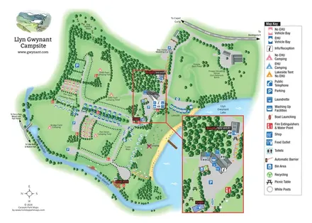
Set beside Llyn Gwynant in the Nant Gwynant valley, this campsite map makes the surrounding water and woodland central to its design. The Afon Glaslyn curves around the camping ground, while the lake forms a broad blue edge to the right. Within that natural outline, named fields, numbered bays and tree-lined drives give visitors a clear picture of how the site is organised.
The artwork distinguishes open camping fields from individually marked tent pitches and vehicle bays. Pink and blue symbols separate accommodation without and with electric hook-up, while orange highlights a small group of lakeside tent pitches. Reception, the shop and shared facilities sit together near the arrival route, with Cegin and Bragdy/BREWERY clearly named nearby.
A large inset enlarges this busy service area without crowding the main plan. The map also identifies boat hire, launching points, a dog walking area and routes towards local walks. A separate wedding venue and visitor car park complete a design that explains both the campsite's practical layout and its distinctive lakeside setting.
The main plan follows the campsite's irregular outline between Llyn Gwynant Lake and the Afon Glaslyn. The river sweeps down the left side and around the southern camping ground, while dense belts of illustrated trees divide the interior into recognisable spaces. Ddôl Fawr, Ddôl Fach, Bridge Field and Pen Helen are labelled as open camping areas. Pen Ddôl and Front Bays contain more individually marked pitches, with vehicle bays arranged in short rows beside the internal drives.
The A498 crosses the upper edge, with arrows towards Capel Curig and Beddgelert. An approach road leads past the day-visitor and wedding car park to reception. A parallel orange dashed walkway connects the car park with the brewery and central facilities. Beyond this route, the Private Barn Field and Llyn Gwynant Barns wedding venue occupy a separate tree-framed area.
The central service hub is outlined in red and linked to a larger inset at lower right. This enlargement clarifies reception, the shop, toilets, washing-up facilities, laundry and shower symbols, bins and recycling, picnic tables, Cegin, the brewery and the automatic barrier. Repeated toilet and fire-extinguisher/water-point symbols provide reference points elsewhere on the plan.
Along the water, the map shows lakeside bays, orange tent markers, white posts, a no-camping area and a small projecting landing structure. Boat hire and launching symbols appear beside the river at the southern end. Western paths point towards the Lake Walk, Watkin Path, Pen y Pass and the Miners and PyG Tracks. The upper-left dog walking area adds another distinct destination. A tall right-hand key explains the symbols, while the scenic title vignette and compass balance the page. The detail view enlarges this same artwork rather than presenting an additional site section.
KEEP EXPLORING
Chosen for shared landscapes, accommodation or facilities.
 Explore the map ↗
United Kingdom
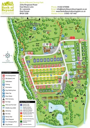
Colour-coded touring pitches, named glamping units and woodland routes at Back of Beyond Touring Park.
 Explore the map ↗
United Kingdom
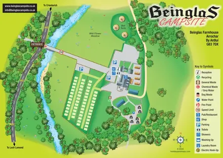
Riverside campsite map with a bridge entrance, wild flower meadow, bell tents and wooded hut paths.
 Explore the map ↗
United Kingdom
Woodland park map with mixed pitches, bell tents, lodges and a fishing lake.
Features may come from the sample artwork, its key or published park information. Approximate numbers describe the drawing and may cover only part of a park. They are intended to help you compare map examples. Current facilities and booking information should be checked with the park.
TAKE A CLOSER LOOK
View the illustrated map in detail or choose a file to download. These are sample maps; contact the park for current visitor information.


LET’S MAP YOUR PARK
For a map quotation, find your park and draw a rough boundary around it. The area you select helps us work out the design time and price.
Draw your park for a quote ↗Or talk to our map designers
01751 473136