
River Stour
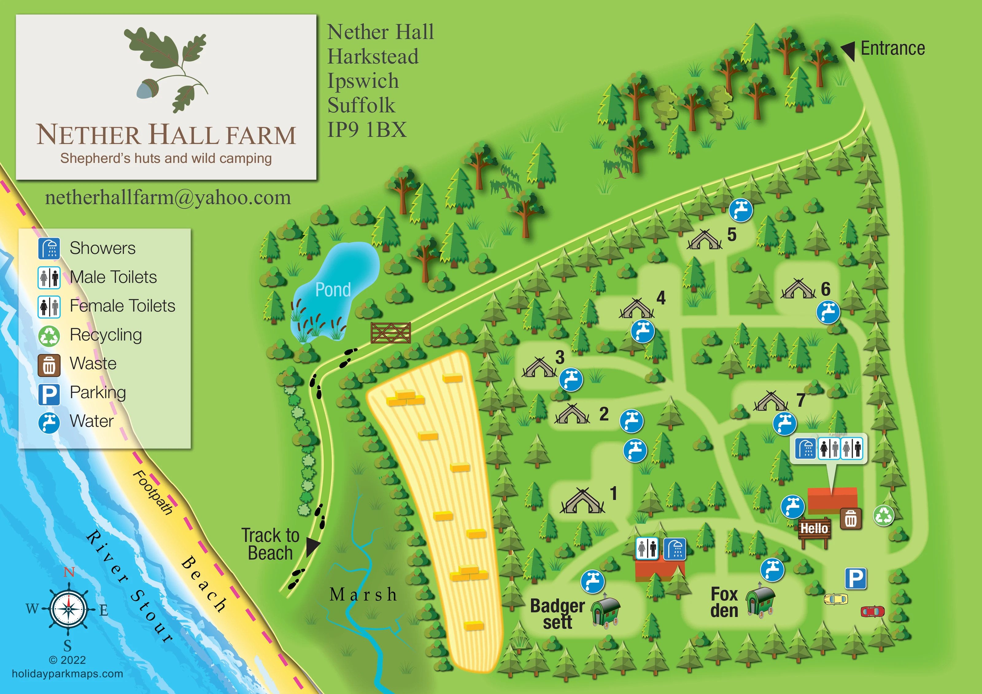
The river forms a substantial diagonal band along the left side, with layered turquoise and pale-blue water textures.
ILLUSTRATED PARK MAP · P546
Nether Hall, Harkstead, Ipswich, Suffolk · United Kingdom
 Enlarge the map ↗
A SENSE OF THE PLACE
Nether Hall Farm offers off-grid shepherd's huts and a small wild campsite at Harkstead on Suffolk's Shotley peninsula. The family-run arable farm has tree-sheltered camping and access to a river beach.
The campsite and shepherd's hut can also be hired for group camping events. The map helps explain the relationship between accommodation, farm grounds and the waterside setting.
LOOK CLOSER
The river forms a substantial diagonal band along the left side, with layered turquoise and pale-blue water textures.
A broad yellow shoreline labelled Beach separates the river from the green farm grounds.
The labelled marsh lies between the beach track and the cultivated field, illustrated with grass tufts and thin branching blue channels.
A labelled, irregular turquoise pond with reeds sits above the beach track, surrounded by trees and shrubs.
Dense rows of conifers frame the campsite, with mixed trees and shrubs dividing its accommodation clearings and extending into the surrounding grounds.
A long golden field with parallel crop lines and illustrated rectangular bales lies between the campsite and marsh, giving the map a recognisable agricultural setting.
Two orange-roofed buildings in the lower campsite carry toilet and shower symbols. The larger right-hand building has a pointer panel showing showers and male and female toilets; the smaller building is marked with toilet and shower icons.
Repeated blue tap symbols are distributed beside camping clearings, the shepherd’s huts and the facility buildings.
Two orange-roofed buildings in the lower campsite carry toilet and shower symbols. The larger right-hand building has a pointer panel showing showers and male and female toilets; the smaller building is marked with toilet and shower icons.
Repeated blue tap symbols are distributed beside camping clearings, the shepherd’s huts and the facility buildings.
Brown waste and green recycling symbols sit beside the larger facility building on the right.
A blue parking symbol and two illustrated cars identify a pale-green parking area at the lower-right end of the arrival route.
A wooden sign reading ‘Hello’ marks the area beside the larger facility building. It is not explicitly labelled as a reception office.
An Entrance label and black triangular pointer mark the upper-right end of the access lane.
A broad pale-green lane follows the right boundary towards parking, while narrower branches connect the accommodation clearings and facilities.
A pale track leaves the upper side of the campsite, passes a drawn wooden gate near the pond, and curves down beside the marsh. Footprint symbols and a Track to Beach pointer distinguish this route.
A magenta dashed line labelled Footpath follows the beach along the River Stour.
The river forms a substantial diagonal band along the left side, with layered turquoise and pale-blue water textures.
A broad yellow shoreline labelled Beach separates the river from the green farm grounds.
The labelled marsh lies between the beach track and the cultivated field, illustrated with grass tufts and thin branching blue channels.
A labelled, irregular turquoise pond with reeds sits above the beach track, surrounded by trees and shrubs.
Dense rows of conifers frame the campsite, with mixed trees and shrubs dividing its accommodation clearings and extending into the surrounding grounds.
A long golden field with parallel crop lines and illustrated rectangular bales lies between the campsite and marsh, giving the map a recognisable agricultural setting.
READING THE MAP
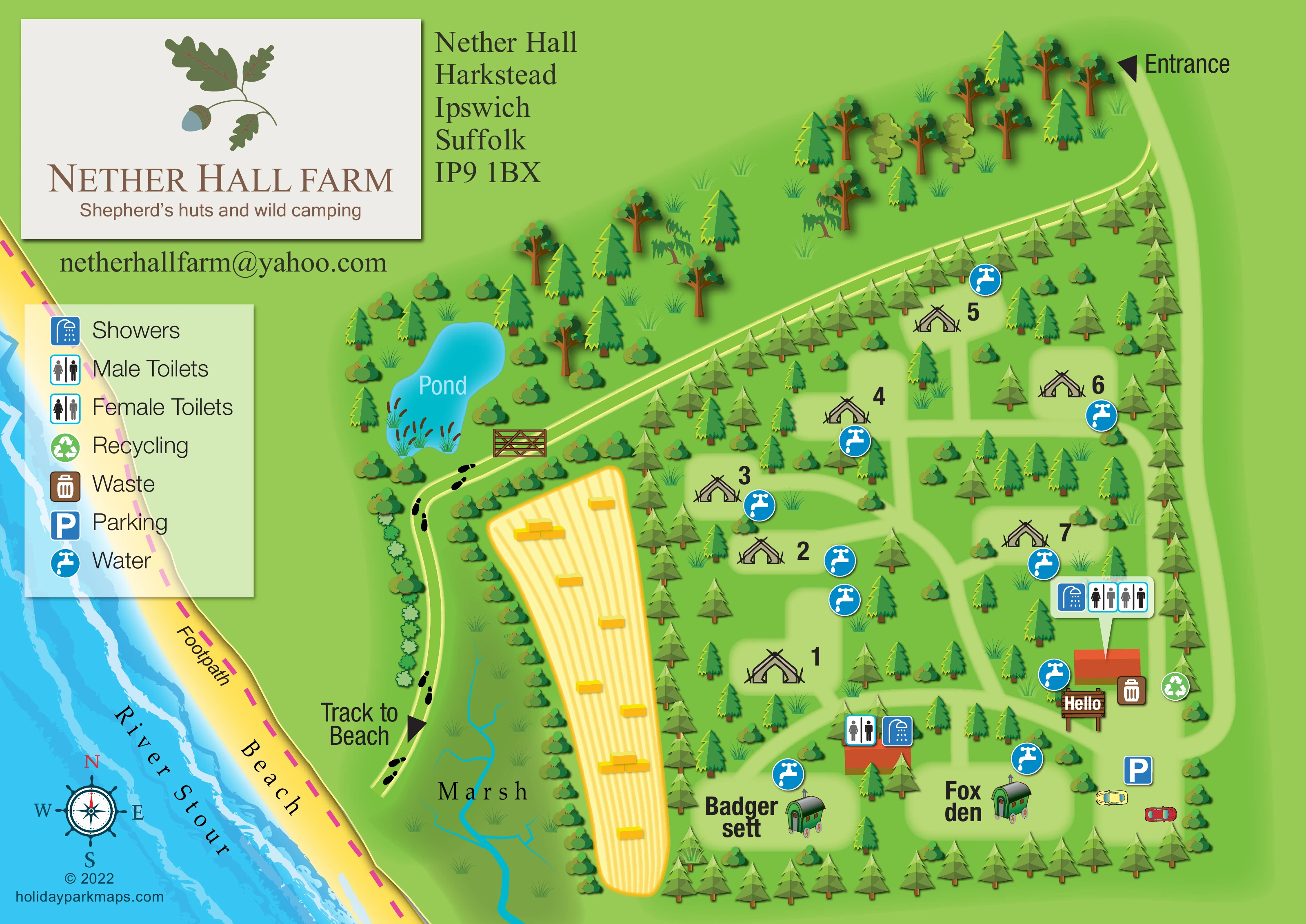
This illustrated map of Nether Hall Farm brings a small Suffolk camping and shepherd’s hut site into the context of its farm grounds and River Stour shoreline. Rather than presenting accommodation as a dense grid, it shows individual camping clearings among trees, with the named huts Badger sett and Fox den along the lower edge. The result is a map in which the setting is as important as the accommodation layout.
The arrival lane runs down the right side towards parking and a wooden ‘Hello’ sign. Blue symbols identify water points, toilets and showers, while waste and recycling markers sit beside the larger facility building. Beyond the campsite, a golden cultivated field, a reed-edged pond and branching marsh channels lead the eye towards the beach and river.
A marked track to the beach and a contrasting dashed shoreline footpath explain how these spaces relate. The oak-and-acorn title panel, illustrated green shepherd’s huts and bright landscape palette give this sample a distinctly rural identity, suited to a small site where visitors need both practical orientation and an understanding of the surrounding landscape.
The single landscape-format map combines the campsite plan with a substantial view of the neighbouring farm and waterfront. Its right-hand accommodation area is enclosed by rows of illustrated conifers, with additional trees and shrubs separating pale-green camping clearings. Large numbers and black tent pictograms identify the camping locations without turning the drawing into a dense technical pitch plan. Along the lower boundary, Badger sett and Fox den are shown as green shepherd’s huts with curved roofs, wheels and chimneys.
An entrance pointer at the upper right introduces a broad access lane that follows the campsite’s outer edge towards a parking area illustrated with cars. Internal branches connect the clearings and the two orange-roofed facility buildings. Toilet and shower icons identify these buildings, including a prominent callout panel on the larger one. Water symbols recur throughout the accommodation area; waste and recycling symbols are grouped near the wooden ‘Hello’ sign.
Outside the campsite, a long field of golden crop stripes and small bale illustrations separates the tree boundary from the marsh. Thin blue channels branch through the marsh towards the bottom of the page. Above it, an irregular turquoise pond is edged with reeds and mixed planting. A wooden gate marks the route that curves past the pond and down beside the marsh, with black footprints reinforcing the labelled track to the beach.
The River Stour and yellow beach sweep diagonally across the left side. A magenta dashed footpath follows the shoreline, while a nautical compass provides orientation below the translucent amenity legend. The upper-left cream branding panel carries an oak-and-acorn motif, the farm name and its camping subtitle. The accompanying detail views enlarge this same composition rather than introducing additional map variants.
KEEP EXPLORING
Chosen for shared landscapes, accommodation or facilities.
 Explore the map ↗
United Kingdom
A colour-zoned coastal park map with touring areas, woodland trails, ponds and a leisure club.
 Explore the map ↗
United Kingdom
Coastal camping, touring and glamping map with a railway-side layout, beach path and illustrated rural surroundings.
 Explore the map ↗
United Kingdom
A woodland estate park map combining caravan loops, touring pitches, riverside paths and Bruce’s Cave landmarks.
Features may come from the sample artwork, its key or published park information. Approximate numbers describe the drawing and may cover only part of a park. They are intended to help you compare map examples. Current facilities and booking information should be checked with the park.
TAKE A CLOSER LOOK
View the illustrated map in detail or choose a file to download. These are sample maps; contact the park for current visitor information.


LET’S MAP YOUR PARK
For a map quotation, find your park and draw a rough boundary around it. The area you select helps us work out the design time and price.
Draw your park for a quote ↗Or talk to our map designers
01751 473136
 netherhall_large.png