
Riverside corridor
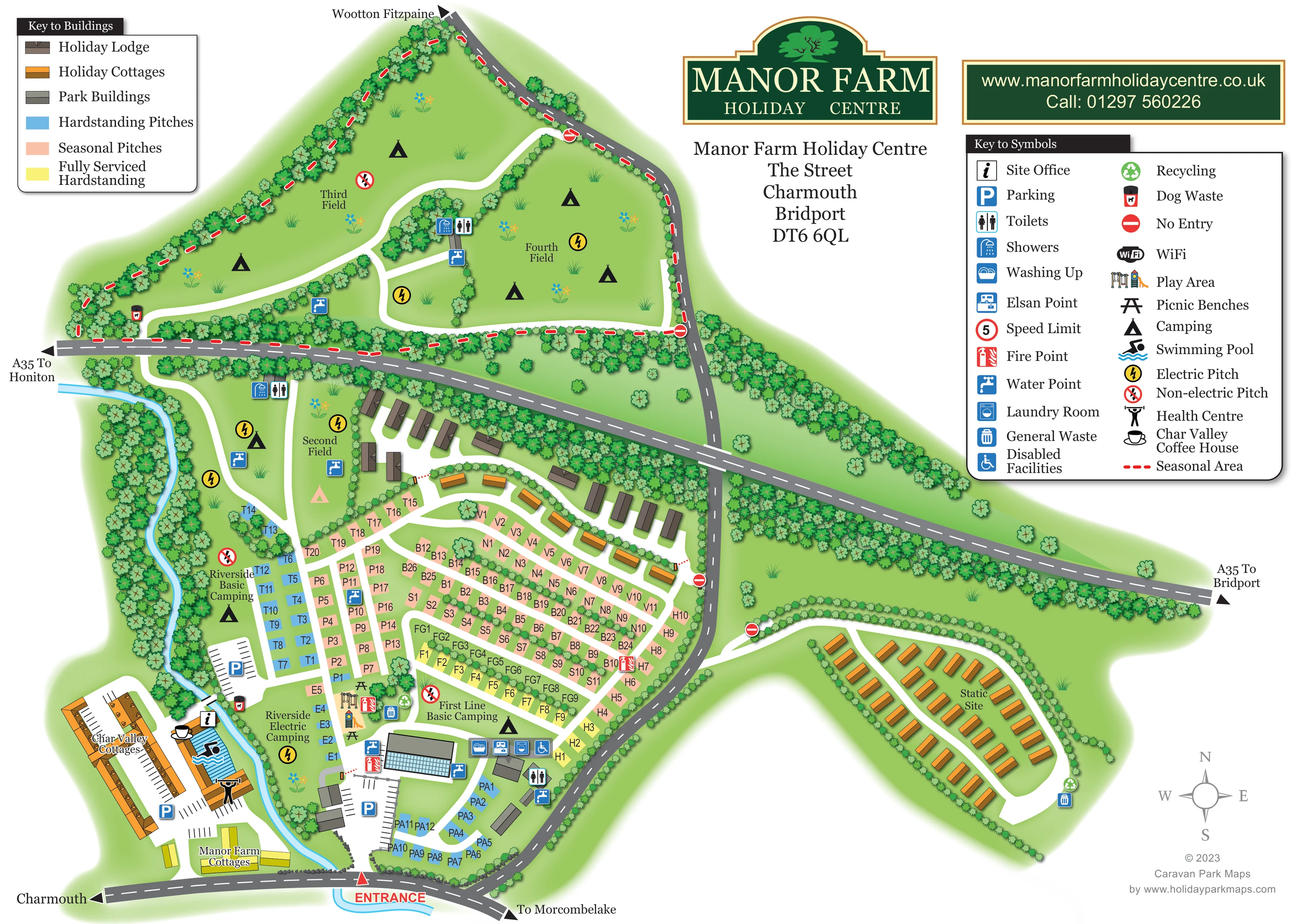
A narrow blue watercourse curves down the western side of the main pitches and past the cottage and leisure complex towards the entrance.
ILLUSTRATED PARK MAP · P207
Charmouth, Bridport, Dorset · United Kingdom
 Enlarge the map ↗
A SENSE OF THE PLACE
Manor Farm Holiday Centre is based at Charmouth, Bridport, Dorset. The site is located in the hills at Charmouth, about 0.6 miles from the Jurassic Coast beach. An adjoining lodge development is marketed for holiday-home ownership. Caravan and camping stays are offered alongside holiday cottages.
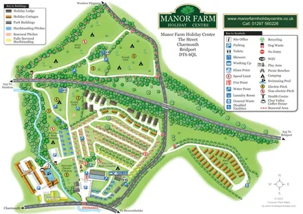
The map brings the site layout and its access routes together in one view, providing a reference for understanding the arrangement of the grounds.
LOOK CLOSER
A narrow blue watercourse curves down the western side of the main pitches and past the cottage and leisure complex towards the entrance.
Dense illustrated vegetation defines the park boundary, river corridor, camping-field divisions and many accommodation rows.
An information symbol locates the office beside the riverside leisure and cottage complex near the entrance.
Blue parking symbols and marked bays identify parking by the cottage complex, riverside pitches and main service buildings.
Toilet and shower symbols appear in the main park and northern camping fields. A wheelchair symbol identifies facilities at the southern service hub without specifying their detailed accessibility.
Washing-up, laundry-room and Elsan-point symbols are grouped around the main service building near the entrance-side pitches.
Repeated blue tap symbols mark water points among the main pitches and in the outlying camping fields.
Grouped waste and recycling symbols appear near the main facilities and the static site; dog-waste bins are marked beside riverside and northern routes.
An information symbol locates the office beside the riverside leisure and cottage complex near the entrance.
Blue parking symbols and marked bays identify parking by the cottage complex, riverside pitches and main service buildings.
Toilet and shower symbols appear in the main park and northern camping fields. A wheelchair symbol identifies facilities at the southern service hub without specifying their detailed accessibility.
Washing-up, laundry-room and Elsan-point symbols are grouped around the main service building near the entrance-side pitches.
Repeated blue tap symbols mark water points among the main pitches and in the outlying camping fields.
Grouped waste and recycling symbols appear near the main facilities and the static site; dog-waste bins are marked beside riverside and northern routes.
Red fire-point symbols are distributed through the main pitch area and beside the service buildings.
An illustrated climbing tower, slide and swings mark a play area beside the central amenity hub.
Black picnic-table symbols sit around the play area and adjacent open space.
A blue striped pool illustration and swimmer symbol identify the pool within the entrance-side leisure complex, west of the river.
The weightlifting symbol from the key is placed at the leisure complex beside the pool.
A cup symbol identifies the coffee house beside the cottages and swimming-pool complex.
Yellow lightning symbols and red crossed-lightning symbols distinguish electric and non-electric areas, alongside explicit riverside camping labels.
WiFi is included in the symbol key, but a corresponding location is not clearly identifiable on the plan.
The key includes a circular speed-limit symbol; its placement on the park plan is not clearly visible.
A narrow blue watercourse curves down the western side of the main pitches and past the cottage and leisure complex towards the entrance.
Dense illustrated vegetation defines the park boundary, river corridor, camping-field divisions and many accommodation rows.
A red ENTRANCE label and triangular marker identify arrival from the southern road, between the Charmouth and Morcombelake directions.
The A35 crosses the composition diagonally with arrows towards Honiton and Bridport. Other road ends point towards Wootton Fitzpaine, Charmouth and Morcombelake.
White lanes connect pitch rows, fields and the static-site loop. Red no-entry symbols mark selected connections to the surrounding grey roads.
A red dashed line matching the seasonal-area key follows the perimeter of the northern camping-field section.
READING THE MAP
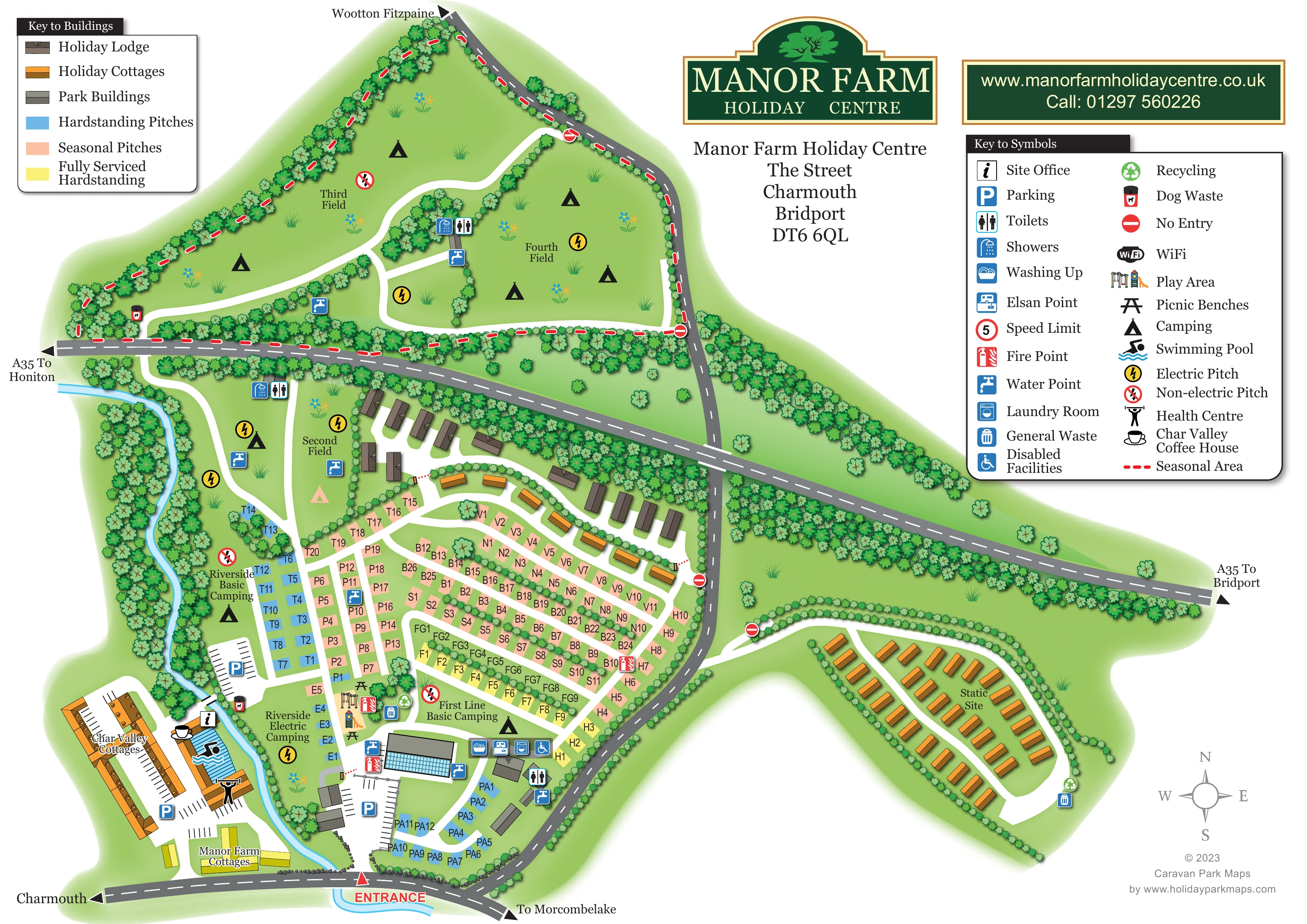
This illustrated map of Manor Farm Holiday Centre brings together a varied holiday site in Charmouth, Dorset: riverside camping, colour-coded pitches, holiday lodges, cottages and a separate static site. Rather than presenting the grounds as a single uniform grid, the artwork makes their different parts easy to recognise. A blue river curves along the western edge, tree-lined camping fields extend to the north, and compact accommodation rows sit around the main facilities near the southern entrance.
The surrounding roads are an important part of the composition. The A35 runs diagonally through the page, while labelled arrows show the connections towards Charmouth, Morcombelake, Wootton Fitzpaine, Honiton and Bridport. Inside the park, white lanes stand out against green lawns and connect named areas with numbered pitches.
Two keys explain the building colours, pitch categories and amenity symbols. The pool, health centre, coffee house, play area and practical camping facilities provide useful landmarks alongside the accommodation. A prominent green-and-gold park logo completes a map suited to a mixed holiday centre with several distinct areas to explain.
The main arrival point is marked in red at the bottom of the sheet, beside the road between Charmouth and Morcombelake. Immediately inside the park, parking areas and grey service buildings anchor the southern end of the accommodation layout. Nearby symbols identify washing-up facilities, laundry, an Elsan point, water, toilets and accessible facilities. A play area and picnic benches sit just above this service hub.
The river follows the western boundary, separating the main pitch area from the entrance-side cottage and leisure complex. Here the map labels Char Valley Cottages and Manor Farm Cottages and locates the swimming pool, health centre and Char Valley Coffee House. Riverside Basic Camping and Riverside Electric Camping are clearly named on the opposite bank.
Across the central park, blue hardstandings, peach seasonal pitches and yellow fully serviced hardstandings form rows divided by white lanes and planted strips. Letter-and-number identifiers provide finer-grained navigation. Brown holiday lodges follow the curved lane below the A35, with orange cottage buildings along the neighbouring route.
Beyond the A35, Third Field and Fourth Field occupy large tree-edged spaces with camping, electricity, water and sanitary symbols. Second Field lies below the road, while First Line Basic Camping is labelled beside the central facilities. A red dashed seasonal-area outline follows the northern section. To the east, the separately labelled Static Site has neat accommodation rows around its own loop lane.
The composition uses an overhead plan with roof details, layered foliage and bright pictograms. Its upper corners contain the building key and amenity key, while the branding and contact panel fill the white space above the eastern section. The accompanying detail views enlarge these same keys and adjoining areas; they are not additional park sections.
KEEP EXPLORING
Chosen for shared landscapes, accommodation or facilities.
 Explore the map ↗
United Kingdom
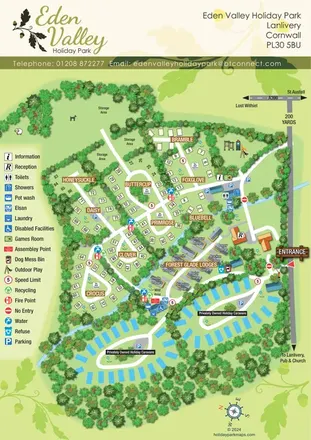
A tree-lined Cornwall park map with flower-named pitches, Forest Glade Lodges and two private-caravan loops.
 Explore the map ↗
United Kingdom
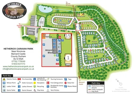
Woodland caravan park map with named pitch areas, walking routes and an enlarged amenities block.
 Explore the map ↗
United Kingdom
A woodland estate park map combining caravan loops, touring pitches, riverside paths and Bruce’s Cave landmarks.
Features may come from the sample artwork, its key or published park information. Approximate numbers describe the drawing and may cover only part of a park. They are intended to help you compare map examples. Current facilities and booking information should be checked with the park.
TAKE A CLOSER LOOK
View the illustrated map in detail or choose a file to download. These are sample maps; contact the park for current visitor information.


LET’S MAP YOUR PARK
For a map quotation, find your park and draw a rough boundary around it. The area you select helps us work out the design time and price.
Draw your park for a quote ↗Or talk to our map designers
01751 473136
 manorfarm_large.png